University of Minnesota
http://www.umn.edu/
612-625-5000
http://www.umn.edu/
612-625-5000
Minnesota Biodiversity Atlas
Bell Museum
Dataset: MIN-Plants
Taxa: Schoenoplectus
Search Criteria: excluding cultivated/captive occurrences
Bell Museum plants | |
 MIN:Plants |  Schoenoplectus subterminalis (Torrey) Soj 835420[1105584]Monson, Paul 50331974-08-07 United States, Minnesota, Itasca, Itasca Co. R-26W, T-59N, S-33. North Star Lake, Trestle landing. 13 mi S of Bigfork;Chippewa National Forest;059N;26W;33, 47.551457 -93.650715 |
MIN:Plants |  Schoenoplectus subterminalis (Torrey) Soj 83919[1105597]Campbell, Jennie C821896-07-00 United States, Minnesota, Stearns, St. Cloud.;;N;;, 45.55 -94.166667 |
MIN:Plants |  Schoenoplectus subterminalis (Torrey) Soj 83920[1105594]Arthur, J.; et al. B4121886-07-25 United States, Minnesota, Saint Louis, Burntside Lake.;Superior National Forest;063N;13W;00, 47.932053 -91.987863 |
MIN:Plants |  Schoenoplectus subterminalis (Torrey) Soj 840558[1105565]Cholewa, A. 2425a1995-08-11 United States, Minnesota, Aitkin, Savanna Portage State Park. Aitkin Co. Savanna Portage State Park, about 17 mi NE of McGregor, Wolf Lake 'outlet' at NE end, on township line T50/51 Aitkin Co. Savanna Portage State Park, about 17 mi NE of McGregor, Wolf Lake 'outlet' at NE end, on township line T50/51N R22W S5/32.. N , 46.85667 -93.15977 |
MIN:Plants |  Schoenoplectus subterminalis (Torrey) Soj 840561[1105564]Cholewa, A. 24201995-08-10 United States, Minnesota, Aitkin, Aitkin Co. Savanna Portage State Park, about 17 mi NE of McGregor, Wolf Lake near SW end, T50N R22W S6 SE1/4 of NE1/4.;Savanna Portage State Park;050N;22W;6, 46.845996 -93.17745 |
MIN:Plants |  Schoenoplectus torreyi (Olney) Palla 251499[1105844]Sheldon, Edmund s.n.1894-08-00 United States, Minnesota, Chisago, Big Lake;;N;;, 45.389408 -92.847992 |
MIN:Plants |  Schoenoplectus torreyi (Olney) Palla 292023[1105855]Moyle, J. 9581933-07-25 United States, Minnesota, Clearwater, Itasca State Park, Clarke Lake;Itasca State Park;143N;36W;26, 47.174126 -95.201258 |
MIN:Plants |  Schoenoplectus torreyi (Olney) Palla 379214[1105856]Lakela, Olga 53831943-08-10 United States, Minnesota, Saint Louis, SE shore of Half Moon Lake, Hwy 53, 6 mi S of Eveleth;;N;;, 47.415502 -92.495535 |
MIN:Plants |  Schoenoplectus torreyi (Olney) Palla 421653[1105847]Ahlgren, Clifford 10511950-08-22 United States, Minnesota, Saint Louis, bay ? mi SW of Curtain Falls, Crooked Lake [label lists Lake Co.];Boundary Waters Canoe Area Wilderness / Superior National Forest;066N;12W;, 48.186787 -91.869968 |
MIN:Plants |  Schoenoplectus torreyi (Olney) Palla 440019[1105836]Smith, Welby 163211989-08-30 United States, Minnesota, Kanabec, Lake Five Wildlife Management Area. Kanabek [sic] County...Lake Five State Wildlife Management Area, on the S side of Bland Lake (Lake Five), about 17 miles N-NE of Mora; NE1/4 NE1/4 sec.8, T42N R22W. 042N 22W 8, 46.1433333 -93.1388889 |
MIN:Plants |  Schoenoplectus torreyi (Olney) Palla 514461[1105839]Myhre, K. 31951992-08-26 United States, Minnesota, Cass, Cass Co.; located 1/4 mi SW of Widow Lake; NE shore of Sand Lake; T140N R29W NW1/4 of SW1/4 of Sec 27;;140N;29W;27, 46.913942 -94.331343 |
MIN:Plants |  Schoenoplectus torreyi (Olney) Palla 525574[1105858]Lakela, Olga 191661955-08-09 United States, Minnesota, Saint Louis, lake S of Gilbert;;N;;, 47.414612 -92.448574 |
MIN:Plants | 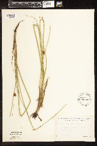 Schoenoplectus torreyi (Olney) Palla 525703[1105850]Lakela, Olga 188031955-07-12 United States, Minnesota, Saint Louis, small lake S of Gilbert;;N;;, 47.414612 -92.448574 |
MIN:Plants | 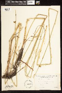 Schoenoplectus torreyi (Olney) Palla 526043[1105857]Lakela, Olga 190761955-08-04 United States, Minnesota, Saint Louis, wild rice fields, Vermilion River 4 mi above the gorge, Gold Mine Camp;;N;;, 48.24114 -92.58556 |
MIN:Plants | 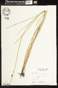 Schoenoplectus torreyi (Olney) Palla 687654[1105853]Wheeler, Gerald; Glaser, Paul 20991977-07-15 United States, Minnesota, Itasca, Approximately 14.5 mi NW of Grand Rapids, edge of Miller Lake, Coll. site no. 117;;056N;27W;12, 47.347361 -93.712506 |
MIN:Plants | 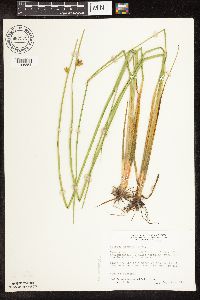 Schoenoplectus torreyi (Olney) Palla 687979[1105854]Wheeler, Gerald; Glaser, Paul 24321977-08-06 United States, Minnesota, Itasca, Approximately 35 mi N of Grand Rapids; Scenic State Park, near Big Fork. NW side of Coon Lake.;Scenic State Park;061N;25W;32, 47.730818 -93.565031 |
MIN:Plants |  Schoenoplectus torreyi (Olney) Palla 83947[1105843]Anderson, A. s.n.1894-08-00 United States, Minnesota, Chisago, Big Lake;;N;;, 45.389408 -92.847992 |
MIN:Plants |  Schoenoplectus torreyi (Olney) Palla 83948[1105849]Bailey, L. s.n.1886-07-16 United States, Minnesota, Washington, White Bear Lake;;030N;21W;, 45.079652 -92.9239 |
MIN:Plants |  Schoenoplectus torreyi (Olney) Palla 83949[1105845]Aiton, G. s.n.1898-06-00 United States, Minnesota, Chisago, [no further data];;;;, 45.522134 -92.91 |
MIN:Plants |  Schoenoplectus torreyi (Olney) Palla 83950[1105846]Sandberg, John s.n.1890-06-00 United States, Minnesota, Chisago, [no further data];;;;, 45.522134 -92.91 |
MIN:Plants | 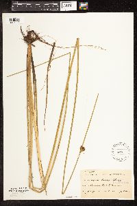 Schoenoplectus torreyi (Olney) Palla 83951[1105848]Taylor, B. T14321892-07-00 United States, Minnesota, Chisago, Center City;;N;;, 45.42608 -92.83619 |
MIN:Plants | 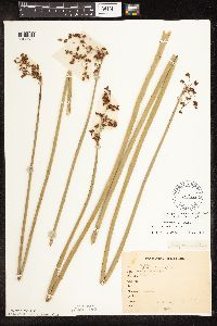 Schoenoplectus tabernaemontani (C.C. Gmelin) Palla 265526[1105684]Goldsmith, G. G3281912-00-00 United States, Minnesota, Rice, Northfield.;;N;;, 44.458298 -93.161604 |
MIN:Plants | 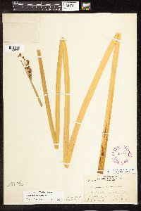 Schoenoplectus tabernaemontani (C.C. Gmelin) Palla 265711[1105773]Ballard, C. B30211901-08-09 United States, Minnesota, Clay, 3 or 4 mi. NE of Moorhead.;;N;;, 46.914782 -96.707684 |
MIN:Plants | 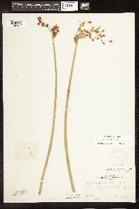 Schoenoplectus tabernaemontani (C.C. Gmelin) Palla 268442[1105787]Kreuholz, R. 1791929-09-03 United States, Minnesota, Big Stone, Big Stone Lake.;;N;;, 45.409244 -96.610864 |
MIN:Plants | 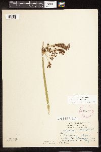 Schoenoplectus tabernaemontani (C.C. Gmelin) Palla 275977[1105762]Grant, Martin 28581929-07-19 United States, Minnesota, Clearwater, Itasca Park. Mississippi River.;Itasca State Park;144N;36W;35, 47.246503 -95.201577 |
MIN:Plants | 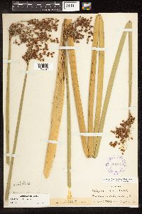 Schoenoplectus tabernaemontani (C.C. Gmelin) Palla 291940[1105724]Hotchkiss, N.; et al. 41011930-09-03 United States, Minnesota, Aitkin, Backwater [Blackwater] Lake, Aitkin Co.;;051N;27W;25, 46.877809 -93.709976 |
MIN:Plants | 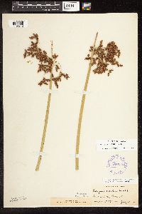 Schoenoplectus tabernaemontani (C.C. Gmelin) Palla 291959[1105812]Hotchkiss, N.; et al. 39431930-07-15 United States, Minnesota, Brown, Linden Lake. Brown Co.;;108N;30W;, 44.152331 -94.429033 |
MIN:Plants | 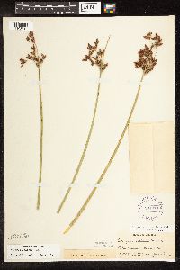 Schoenoplectus tabernaemontani (C.C. Gmelin) Palla 291979[1105813]Hotchkiss, N.; et al. 39481930-07-16 United States, Minnesota, Brown, Lake Hanska. Brown Co.;;;;, 44.145015 -94.61931 |
MIN:Plants |  Schoenoplectus tabernaemontani (C.C. Gmelin) Palla 291987[1105798]Keck, W.; et al. 3931926-08-03 United States, Minnesota, Rice, French Lake.;;;;, 44.339099 -93.391896 |
MIN:Plants |  Schoenoplectus tabernaemontani (C.C. Gmelin) Palla 291989[1105800]Keck, W.; et al. 4371926-08-20 United States, Minnesota, Hennepin, Lake Minnetonka.;;;;, 44.924201 -93.595343 |
MIN:Plants |  Schoenoplectus tabernaemontani (C.C. Gmelin) Palla 307249[1105679]Oosting, H. 281121928-07-28 United States, Minnesota, Anoka, Ham Lake.;;032N;23W;, 45.254503 -93.203833 |
MIN:Plants |  Schoenoplectus tabernaemontani (C.C. Gmelin) Palla 307250[1105728]Oosting, H. 281611928-08-04 United States, Minnesota, Ramsey, Snail Lake.;Snail Lake Vadnais Lake County Park;030N;23W;, 45.080032 -93.166927 |
MIN:Plants | 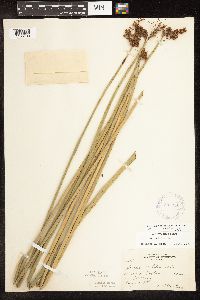 Schoenoplectus tabernaemontani (C.C. Gmelin) Palla 307251[1105738]Oosting, H. 30481930-08-27 United States, Minnesota, Dakota, Minnesota River Bottoms, above Ft. Snelling.;;028N;23W;, 44.873785 -93.188495 |
MIN:Plants | 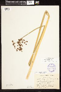 Schoenoplectus tabernaemontani (C.C. Gmelin) Palla 336526[1105759]Smith, L.; Moyle, J. 4911936-09-02 United States, Minnesota, Itasca, Ball Club Lake;Chippewa National Forest;N;;, 47.358018 -93.94401 |
MIN:Plants | 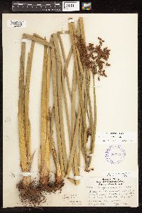 Schoenoplectus tabernaemontani (C.C. Gmelin) Palla 337016[1105808]Lakela, Olga 17401936-08-19 United States, Minnesota, Saint Louis, Near North Breakwater, U.S. Government Property, Duluth.;;050N;14W;20, 46.800337 -92.142643 |
MIN:Plants | 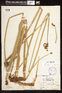 Schoenoplectus tabernaemontani (C.C. Gmelin) Palla 337619[1105628]Lakela, Olga 16651936-08-08 United States, Minnesota, Saint Louis, Oatka Beach addition, Duluth.;Minnesota Point;049N;13W;18, 46.75082 -92.072247 |
MIN:Plants |  Schoenoplectus tabernaemontani (C.C. Gmelin) Palla 338068[1105726]Smith, L.; Moyle, J. 4901936-09-02 United States, Minnesota, Itasca, Bena Dist, Ball Club Lake;;N;;, 47.358018 -93.94401 |
MIN:Plants |  Schoenoplectus tabernaemontani (C.C. Gmelin) Palla 338089[1105627]Smith, L.; Moyle, J. 71936-07-27 United States, Minnesota, Itasca, Cut Foot Sioux Lake;Chippewa National Forest / Leech Lake Indian Reservation;147N;27W;, 47.542194 -94.09753 |
MIN:Plants |  Schoenoplectus tabernaemontani (C.C. Gmelin) Palla 338131[1105733]Moyle, J. 23181936-08-11 United States, Minnesota, Big Stone, On an island in Big Stone Lake, 6 mi. N of Ortonville.;;N;;, 45.35962 -96.50502 |
MIN:Plants |  Schoenoplectus tabernaemontani (C.C. Gmelin) Palla 346216[1105736]Moyle, J. 28881937-08-18 United States, Minnesota, Waseca, Lake Elysian.;;109N;24W;, 44.17629 -93.69587 |
MIN:Plants |  Schoenoplectus tabernaemontani (C.C. Gmelin) Palla 346219[1105708]Moyle, J. 29681938-08-23 United States, Minnesota, Jackson, N end of Heron Lake;;N;;, 43.771287 -95.272522 |
MIN:Plants |  Schoenoplectus tabernaemontani (C.C. Gmelin) Palla 346694[1105797]Morse, Marius s.n. United States, Minnesota, Saint Louis, Bates Lake [White Lake].;;055N;12W;, 47.241833 -91.855903 |
MIN:Plants |  Schoenoplectus tabernaemontani (C.C. Gmelin) Palla 347629[1105758]Moyle, J. 31841938-08-09 United States, Minnesota, Mille Lacs, Spirit Island in Lake Mille Lacs.;;042N;26W;, 46.11234 -93.620504 |
MIN:Plants |  Schoenoplectus tabernaemontani (C.C. Gmelin) Palla 350200[1105824]McCartney, James 591938-06-28 United States, Minnesota, Scott, North side [other collections indicated south side] of Minn. River between St. Highway No. 50 and Savage, Scott County;;;;, 44.78592 -93.3407 |
MIN:Plants |  Schoenoplectus tabernaemontani (C.C. Gmelin) Palla 350597[1105729]Moyle, J. 32651938-09-30 United States, Minnesota, Ramsey, Ramsey Co. McCarrons Lake.;;029N;23W;, 44.992077 -93.166387 |
MIN:Plants |  Schoenoplectus tabernaemontani (C.C. Gmelin) Palla 350844[1105799]Hedman, H. 461938-07-00 United States, Minnesota, Hennepin, N shore of Brown's Bay, Lake Minnetonka.;;117N;23W;, 44.934923 -93.584208 |
MIN:Plants |  Schoenoplectus tabernaemontani (C.C. Gmelin) Palla 353320[1105767]Lakela, Olga 27541938-08-17 United States, Minnesota, Saint Louis, Shore of Frying Pan Lake, Palo.;;057N;15W;, 47.415324 -92.239713 |
MIN:Plants |  Schoenoplectus tabernaemontani (C.C. Gmelin) Palla 354266[1105739]Moyle, J. 12741934-07-20 United States, Minnesota, Clearwater, Itasca Park.;Itasca State Park;143N;36W;29, 47.173717 -95.265521 |
MIN:Plants |  Schoenoplectus tabernaemontani (C.C. Gmelin) Palla 358689[1105662]Stork, H. 10751925-06-00 United States, Minnesota, Itasca, Bowstring;Chippewa National Forest;;;, 47.54306 -93.79639 |
MIN:Plants |  Schoenoplectus tabernaemontani (C.C. Gmelin) Palla 359121[1105757]Moyle, J. 33631939-09-05 United States, Minnesota, Mille Lacs, Rum River, between Milaca and Onamia.;;N;;, 45.915789 -93.674262 |
MIN:Plants |  Schoenoplectus tabernaemontani (C.C. Gmelin) Palla 359219[1105753]Moyle, J. 33721939-07-29 United States, Minnesota, Morrison, Bars in the Mississippi River, above Little Falls.;;N;;, 46.024052 -94.350829 |
MIN:Plants |  Schoenoplectus tabernaemontani (C.C. Gmelin) Palla 360178[1105660]Rosendahl, C.; Butters, F. 67561936-08-31 United States, Minnesota, Pine, Sturgeon Lake.;;045N;19W;, 46.374946 -92.7409 |
MIN:Plants |  Schoenoplectus tabernaemontani (C.C. Gmelin) Palla 361731[1105665]Jacobs, D. s.n.1940-07-17 United States, Minnesota, Wright, Cedar Lake.;;N;;, 45.263182 -93.873624 |
MIN:Plants |  Schoenoplectus tabernaemontani (C.C. Gmelin) Palla 362186[1105635]Horton, E. s.n.1936-08-04 United States, Minnesota, Saint Louis, Minnesota Point, Duluth.;Minnesota Point;049N;13W;18, 46.72833 -92.04778 |
MIN:Plants |  Schoenoplectus tabernaemontani (C.C. Gmelin) Palla 365000[1105754]Buell, Murray 20181940-08-19 United States, Minnesota, Becker, De Soto Lake, Itasca Park.;Itasca State Park;142N;36W;, 47.145259 -95.222785 |
MIN:Plants |  Schoenoplectus tabernaemontani (C.C. Gmelin) Palla 366495[1105720]Rosendahl, C.; et al. 72381939-07-20 United States, Minnesota, Freeborn, Along the Iowa-Minn. state line, E of Emmons.;;;;, 43.54296 -93.468448 |
MIN:Plants |  Schoenoplectus tabernaemontani (C.C. Gmelin) Palla 381334[1105785]Moore, John 156111942-06-29 United States, Minnesota, Douglas, Osakis.;;128N;36W;, 45.889447 -95.201797 |
MIN:Plants | 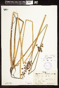 Schoenoplectus tabernaemontani (C.C. Gmelin) Palla 385445[1105661]Moyle, J. 38061944-07-27 United States, Minnesota, Saint Louis, St. Louis Co. Frying Pan Lake near Palo.;;057N;15W;, 47.415324 -92.239713 |
MIN:Plants | 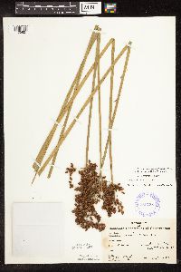 Schoenoplectus tabernaemontani (C.C. Gmelin) Palla 385758[1105827]Moyle, J. 38831944-08-10 United States, Minnesota, Saint Louis, Hay Creek.;;050N;16W;33, 46.772179 -92.375048 |
MIN:Plants | 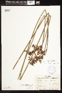 Schoenoplectus tabernaemontani (C.C. Gmelin) Palla 385785[1105755]Moyle, J. 38341944-08-30 United States, Minnesota, Saint Louis, A small stream tributary to Floodwood Lake.;;N;;, 47.162967 -93.053636 |
MIN:Plants | 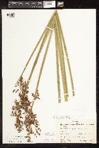 Schoenoplectus tabernaemontani (C.C. Gmelin) Palla 385847[1105780]Moyle, J. 40991945-08-10 United States, Minnesota, Waseca, Willis Lake.;;108N;24W;, 44.152568 -93.70784 |
MIN:Plants |  Schoenoplectus tabernaemontani (C.C. Gmelin) Palla 385848[1105676]Moyle, J. 39631945-08-27 United States, Minnesota, Lyon, Lake Marshall.;;N;;, 44.388338 -95.736642 |
MIN:Plants |  Schoenoplectus tabernaemontani (C.C. Gmelin) Palla 385851[1105811]Moyle, J. 40221945-08-08 United States, Minnesota, Steele, Rice Lake;;N;;, 44.085074 -93.060166 |
MIN:Plants |  Schoenoplectus tabernaemontani (C.C. Gmelin) Palla 392953[1105766]Lakela, Olga 64941946-07-01 United States, Minnesota, Saint Louis, Sandbar Island in the Duluth Harbor.;;N;;, 46.75082 -92.072247 |
MIN:Plants |  Schoenoplectus tabernaemontani (C.C. Gmelin) Palla 401478[1105734]Nurnberger, P. 29121929-07-19 United States, Minnesota, Clearwater, Clearwater River. Sinclair twp.;;149N;36W;6, 47.753265 -95.312512 |
MIN:Plants |  Schoenoplectus tabernaemontani (C.C. Gmelin) Palla 405436[1105634]Benson, Robert 1571941-08-21 United States, Minnesota, Kandiyohi, Kandiyohi Co. State game refuge - New London, T121 R33 [prob. Dietrich Lange Wildlife Management Area];Dietrich Lange Wildlife Management Area;121N;33W;, 45.282569 -94.824825 |
MIN:Plants |  Schoenoplectus tabernaemontani (C.C. Gmelin) Palla 411959[1105815]Moore, John; Moore, Marjorie 120981939-08-23 United States, Minnesota, Koochiching, Koochiching Co.; Along the south bank of the Rainy River, W of Birchdale. Along the S bank of the Rainy River, W of Birchdale.. 160N 27W , 48.636117 -94.105012 |
MIN:Plants |  Schoenoplectus tabernaemontani (C.C. Gmelin) Palla 412195[1105683]Moore, John; Moore, Marjorie 111891939-07-27 United States, Minnesota, Lake of the Woods, Along the W side of Harrison River, Northwese Angle.;Northwest Angle;168N;35W;, 49.37234 -95.14787 |
MIN:Plants |  Schoenoplectus tabernaemontani (C.C. Gmelin) Palla 412868[1105705]Moore, John; Moore, Marjorie 114771939-08-05 United States, Minnesota, Roseau, N bank of the Warroad River, Warroad;;N;;, 48.905266 -95.314404 |
MIN:Plants |  Schoenoplectus tabernaemontani (C.C. Gmelin) Palla 419702[1105771]Lakela, Olga 111301950-08-05 United States, Minnesota, Saint Louis, Under the bridge on Fairbanks Road, N branch of the Whiteface River.;;N;;, 47.161945 -92.535781 |
MIN:Plants | 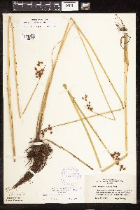 Schoenoplectus tabernaemontani (C.C. Gmelin) Palla 421112[1105756]Lakela, Olga 109781950-07-30 United States, Minnesota, Saint Louis, Opposite the Island Farm, NW of Floodwood, hwy. 2, St. Louis Co.;;050N;20W;, 46.986052 -93.01354 |
MIN:Plants | 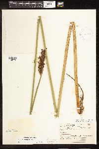 Schoenoplectus tabernaemontani (C.C. Gmelin) Palla 421482[1105770]Ahlgren, Clifford 9841950-08-16 United States, Minnesota, Lake, Quetico-Superior Wilderness Research Center, Basswood Lake, Ely. N shore of Hula Lake.;Boundary Waters Canoe Area Wilderness / Superior National Forest;N;;, 48.014406 -91.6101 |
MIN:Plants | 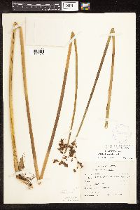 Schoenoplectus tabernaemontani (C.C. Gmelin) Palla 424012[1105707]Emanuel, J. 3381946-09-11 United States, Minnesota, Itasca, County: Itasca. Locality: Nashwauk Township - Crooked Lake;;057N;24W;01, 47.450034 -93.333592 |
MIN:Plants | 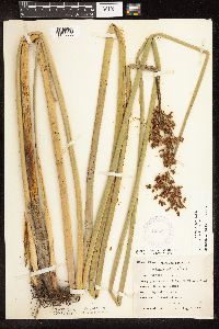 Schoenoplectus tabernaemontani (C.C. Gmelin) Palla 425854[1105633]Emanuel, J. 5691951-08-05 United States, Minnesota, Winona, Just N of Dam 5A, Winona Pool.;;107N;07W;, 44.052588 -91.672687 |
MIN:Plants |  Schoenoplectus tabernaemontani (C.C. Gmelin) Palla 425924[1105706]Moyle, J. s.n.1951-08-15 United States, Minnesota, Roseau, along Roseau River;;N;;, 48.67965 -95.624149 |
MIN:Plants |  Schoenoplectus tabernaemontani (C.C. Gmelin) Palla 433330[1105663]Abbott, Robinson s.n.1989-09-05 United States, Minnesota, Grant, Grant County...Big Lake, just E. of Herman on rt. 27.;;127N;43W;18, 45.810499 -96.120024 |
MIN:Plants |  Schoenoplectus tabernaemontani (C.C. Gmelin) Palla 433331[1105789]Abbott, Robinson s.n.1961-07-22 United States, Minnesota, Stevens, Stevens County...PDT [Pomme de Terre] River, 1 mi. E. of Morris.;;125N;41W;31, 45.592721 -95.871809 |
MIN:Plants |  Schoenoplectus tabernaemontani (C.C. Gmelin) Palla 433406[1105651]Myhre, K. 56151995-06-19 United States, Minnesota, Crow Wing, Crow Wing Co.; Located 4 miles southeast of the town of Brainerd. Plants occur along the south bays of Perch Lake; T 133 Crow Wing Co.; Located 4 miles southeast of the town of Brainerd. Plants occur along the south bays of Perch Lake; T 133N R 29W SW1/4 of NE1/4 of sec 13. 133N 29W 13, 46.332469 -94.275724 |
MIN:Plants |  Schoenoplectus tabernaemontani (C.C. Gmelin) Palla 433477[1105650]Myhre, K. 56521995-06-21 United States, Minnesota, Crow Wing, Crow Wing Co.; Located in the southwest corner of Crow Wing county. Plants occur along the southeast shore of Sebie Lake Crow Wing Co.; Located in the southwest corner of Crow Wing county. Plants occur along the southeast shore of Sebie Lake; T 43N R 32W SE1/4 of NW1/4 of Sec 36. 043N 32W 36, 46.164356 -94.324316 |
MIN:Plants |  Schoenoplectus tabernaemontani (C.C. Gmelin) Palla 439565[1105717]Smith, Welby 129701987-06-16 United States, Minnesota, Washington, Washington County...on the E side of Highway 4, about 1/2 mi NW of Marine on St. Croix; about 150 ft above the floodplain of the St. Croix River; SW1/4 NE1/4 sec.1, T31N R20W. 031N 20W 1, 45.2061111 -92.7797222 |
MIN:Plants |  Schoenoplectus tabernaemontani (C.C. Gmelin) Palla 440380[1105617]Myhre, K. 29381992-08-04 United States, Minnesota, Cass, Cass Co. Located just W of the Mississippi River; T145N R26W SW1/4 of SW1/4 of Sec 34;Chippewa National Forest / Leech Lake Indian Reservation;145N;26W;34, 47.332254 -93.956198 |
MIN:Plants |  Schoenoplectus tabernaemontani (C.C. Gmelin) Palla 444936[1105782]Moore, John; et al. 176211945-07-09 United States, Minnesota, Nobles, 5 mi. NW of Reading.;;;;, 43.754764 -95.783906 |
MIN:Plants |  Schoenoplectus tabernaemontani (C.C. Gmelin) Palla 448395[1105710]Moore, John; et al. 176911945-07-10 United States, Minnesota, Martin, 1 mi. W of Fairmont.;;;;, 43.652176 -94.481102 |
MIN:Plants |  Schoenoplectus tabernaemontani (C.C. Gmelin) Palla 453148[1105652]Myhre, K. 56381995-06-20 United States, Minnesota, Aitkin, Aitkin Co.; Located one half mile southwest of Elm Island Lake. Plants occur along the west bays of Lone Lake; T 46N R 2 Aitkin Co.; Located one half mile southwest of Elm Island Lake. Plants occur along the west bays of Lone Lake; T 46N R 26W NW1/4 of SE1/4 of sec 30. 046N 26W 30, 46.43923 -93.675342 |
MIN:Plants |  Schoenoplectus tabernaemontani (C.C. Gmelin) Palla 453677[1105613]Myhre, K. 45831993-08-30 United States, Minnesota, Pine, Pine Co.; Located 7 miles east of the town of Cloverdale; Wilbur Lake; T 41N R 18W SE1/4 of NW1/4 of Sec 23;;041N;18W;23, 46.019309 -92.58488 |
MIN:Plants |  Schoenoplectus tabernaemontani (C.C. Gmelin) Palla 458698[1105619]Lee, Michael MDL2881993-08-04 United States, Minnesota, Dakota, Dakota Co.; Chub Lake; T113N R20W SW1/4 of NE1/4 of Sec 33;;113N;20W;33, 44.551096 -93.227872 |
MIN:Plants |  Schoenoplectus tabernaemontani (C.C. Gmelin) Palla 460623[1105747]Smith, Welby 207161992-07-13 United States, Minnesota, Wadena, Wadena County...Between Trunk Highway 10 and the Burlington Northern Railroad tracks, about one mile southeast of Verndale...T 134N R 34W NW1/4 of SW1/4 of Sec 28. 134N 34W 28, 46.3869444 -94.9852778 |
MIN:Plants |  Schoenoplectus tabernaemontani (C.C. Gmelin) Palla 463283[1105629]Lakela, Olga 151951952-07-17 United States, Minnesota, Saint Louis, Daly Bay, S shore of Kabetogama Lake.;Voyageurs National Park;N;;, 48.42954 -92.94039 |
MIN:Plants |  Schoenoplectus tabernaemontani (C.C. Gmelin) Palla 463284[1105630]Lakela, Olga 15031952-07-15 United States, Minnesota, Saint Louis, Daly Bay, S shore of Kabetogama Lake.;Voyageurs National Park;N;;, 48.42954 -92.94039 |
MIN:Plants |  Schoenoplectus tabernaemontani (C.C. Gmelin) Palla 466871[1105615]Smith, Michael 3241997-06-26 United States, Minnesota, Saint Louis, Voyageurs National Park. St Louis Co.; DMX-D-03; UTM 506367E 5377977N;Voyageurs National Park;;;, 48.483546 -92.838098 |
MIN:Plants |  Schoenoplectus tabernaemontani (C.C. Gmelin) Palla 471870[1105653]Myhre, K. 55201995-06-12 United States, Minnesota, Aitkin, Aitkin Co.; Located one mile northeast of greater downtown Glen; northeast shore of Clear Lake; T 46N R 25W SW1/4 of SE1 Aitkin Co.; Located one mile northeast of greater downtown Glen; northeast shore of Clear Lake; T 46N R 25W SW1/4 of SE1/4 of sec 28. 046N 25W 28, 46.439945 -93.504805 |
MIN:Plants | 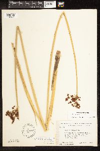 Schoenoplectus tabernaemontani (C.C. Gmelin) Palla 499887[1105637]Ball, E. 111946-06-00 United States, Minnesota, Marshall, Mud Lake National Wildlife Refuge.;Agassiz National Wildlife Refuge;156N;41W;15, 48.331199 -95.906352 |
MIN:Plants | 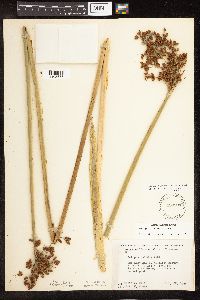 Schoenoplectus tabernaemontani (C.C. Gmelin) Palla 499901[1105655]Ball, E. 221946-07-22 United States, Minnesota, Marshall, Marshall Co. Mud Lake National Wildlife Refuge, R.41W, T.156N, Sec.15.;Agassiz National Wildlife Refuge;156N;041;15, 48.331199 -95.906352 |
MIN:Plants | 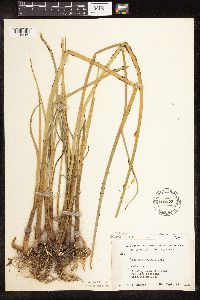 Schoenoplectus tabernaemontani (C.C. Gmelin) Palla 500725[1105685]Harris, S. 4031953-09-12 United States, Minnesota, Marshall, Plot 45. In M. CCC Pool, Mud Lake National Wildlife Refuge.;Agassiz National Wildlife Refuge;N;;, 48.345231 -95.945894 |
MIN:Plants | 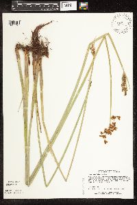 Schoenoplectus tabernaemontani (C.C. Gmelin) Palla 506099[1105621]Lee, Michael MDL10291995-06-20 United States, Minnesota, Wabasha, Wabasha Co.; ridgetop along Hwy 60 E of Zumbro Falls 2 1/4 mi; T110N R13W SWSE 33;;110N;13W;33, 44.288625 -92.380696 |
MIN:Plants |  Schoenoplectus tabernaemontani (C.C. Gmelin) Palla 507215[1105791]Moore, John 206281950-06-19 United States, Minnesota, Martin, W end of Fox Lake.;;N;;, 43.677018 -94.697833 |
MIN:Plants |  Schoenoplectus tabernaemontani (C.C. Gmelin) Palla 507295[1105781]Moore, John 207491950-06-23 United States, Minnesota, Faribault, SE shore of Walnut Lake.;;N;;, 43.65893 -93.78376 |
MIN:Plants |  Schoenoplectus tabernaemontani (C.C. Gmelin) Palla 508460[1105776]Smith, Welby 144201988-07-01 United States, Minnesota, Nobles, Nobles County...About 4 mi W of Worthington; on the right-of-way of the Chicago and Northwestern Railroad line; NE1/4 SW1/4 sec.25, T102N R41W. 102N 41W 25, 43.6061111 -93.7027778 |
MIN:Plants |  Schoenoplectus tabernaemontani (C.C. Gmelin) Palla 508722[1105616]Lee, Michael MDL9971995-06-09 United States, Minnesota, Wabasha, McCarthy Lake Wildlife Management Area. Wabasha Co.; along old channels of the Zumbro River in the Mississippi River floodplain 3 mi SSE of Kellogg; McCarthy La Wabasha Co.; along old channels of the Zumbro River in the Mississippi River floodplain 3 mi SSE of Kellogg; McCarthy Lake WMA. T109N R10W NWSW 1. 109N 10W 1, 44.249964 -91.954363 |
MIN:Plants |  Schoenoplectus tabernaemontani (C.C. Gmelin) Palla 514311[1105618]Smith, Welby 212041992-07-31 United States, Minnesota, Waseca, Waseca Co.; at the W end of Lily Lake, about 1 mile E of Elysian; T108N R23W NW1/4 of NW1/4 of Sec 6 Waseca Co.; at the W end of Lily Lake, about 1 mile E of Elysian; T108N R23W NW1/4 of NW1/4 of Sec.6. 108N 23W 6, 44.1944427 -93.6461105 |
Google Map
Google Maps is a web mapping service provided by Google that features a map that users can pan (by dragging the mouse) and zoom (by using the mouse wheel). Collection points are displayed as colored markers that when clicked on, displays the full information for that collection. When multiple species are queried (separated by semi-colons), different colored markers denote each individual species.