University of Minnesota
http://www.umn.edu/
612-625-5000
http://www.umn.edu/
612-625-5000
Minnesota Biodiversity Atlas
Bell Museum
Dataset: MIN-Plants
Taxa: Schoenoplectus
Search Criteria: excluding cultivated/captive occurrences
Bell Museum plants | |
 MIN:Plants |  Schoenoplectus pungens (Vahl) Palla 83127[1105518]Sheldon, Edmund s.n.1895-05-00 United States, Minnesota, Ramsey, Ramsey Co.;;;;, 45.02 -93.1 |
MIN:Plants |  Schoenoplectus pungens (Vahl) Palla 83128[1105526]Frost, W. T2581892-07-00 United States, Minnesota, Kandiyohi, Willmar.;;119N;35W;, 45.110139 -95.062995 |
MIN:Plants |  Schoenoplectus pungens (Vahl) Palla 83129[1105520]Campbell, Jennie 1911896-07-00 United States, Minnesota, Stearns, St. Cloud.;;N;;, 45.55 -94.166667 |
MIN:Plants |  Schoenoplectus pungens (Vahl) Palla 83131[1105516]Campbell, Jennie 811891-07-00 United States, Minnesota, Stearns, St. Cloud.;;N;;, 45.55 -94.166667 |
MIN:Plants |  Schoenoplectus pungens (Vahl) Palla 83132[1105529]Taylor, B. T15311892-08-00 United States, Minnesota, Chisago, Lindstrom.;;N;;, 45.389408 -92.847992 |
MIN:Plants |  Schoenoplectus pungens (Vahl) Palla 83133[1105527]Sheldon, Edmund S861891-06-00 United States, Minnesota, Le Sueur, Elysian;;109N;24W;, 44.239498 -93.707142 |
MIN:Plants |  Schoenoplectus pungens (Vahl) Palla 83134[1105522]Kassube, J. s.n.1878-07-00 United States, Minnesota, Hennepin, Minneapolis.;;N;;, 44.979965 -93.263836 |
MIN:Plants |  Schoenoplectus pungens (Vahl) Palla 83135[1105519]Taylor, B. s.n.1892-08-00 United States, Minnesota, Chisago, Lindstrom.;;N;;, 45.389408 -92.847992 |
MIN:Plants |  Schoenoplectus pungens (Vahl) Palla 83136[1105521]Sheldon, Edmund s.n.1895-05-00 United States, Minnesota, Ramsey, Ramsey Co.;;;;, 45.02 -93.1 |
MIN:Plants |  Schoenoplectus pungens (Vahl) Palla 83137[1105525]Frost, W. F2581892-07-00 United States, Minnesota, Kandiyohi, Willmar;;N;;, 45.121908 -95.043342 |
MIN:Plants |  Schoenoplectus pungens (Vahl) Palla 83138[1105491]Sheldon, Edmund S39371892-08-00 United States, Minnesota, Otter Tail, Annie Battle Lake.;;133N;40W;, 46.32559 -95.717658 |
MIN:Plants |  Schoenoplectus pungens (Vahl) Palla 833819[1105477]Smith, Welby 141521988-05-31 United States, Minnesota, Lac Qui Parle, Lac Qui Parle Co. About 9 mi SW of Madison. On the N side of the West Branch Lac Qui Parle River. SW1/4 NE1/4 sec 13, T1 Lac Qui Parle Co. About 9 mi SW of Madison. On the N side of the West Branch Lac Qui Parle River. SW1/4 NE1/4 sec 13, T117N R46W. 117N 46W 13, 44.883131 -96.10804 |
MIN:Plants |  Schoenoplectus pungens (Vahl) Palla 833874[1105553]Smith, Welby 141631988-05-31 United States, Minnesota, Lac Qui Parle, Lac Qui Parle Co. About 1 mi S-SE of Nassau, on the S side of Co Hwy 24;, on the E shore of Peg Lake. SE1/4 NE1/4 sec 4, Lac Qui Parle Co. About 1 mi S-SE of Nassau, on the S side of Co Hwy 24;, on the E shore of Peg Lake. SE1/4 NE1/4 sec 4, T118N R46W.. 118N 46W 4, 45.059123 -96.424985 |
MIN:Plants | Schoenoplectus pungens (Vahl) Palla 835515[]Monson, Paul 44721960-07-04 United States, Minnesota, Mahnomen, Mahnomen Co. Popple Grove Twp. R-42, T-143, SW1/4, S-25.;Waubun Prairie Wildlife Management Area / White Earth Indian Reservation;143N;42W;25, 47.173142 -95.943662 |
MIN:Plants |  Schoenoplectus pungens (Vahl) Palla 839129[1105469]Smith, Welby 177291990-08-07 United States, Minnesota, Red Lake, Red Lake County ... At 'Old Crossing Treaty State Wayside Park'. On the N bank of the Red Lake River, about 6 miles W of the town of Red Lake Falls ... T151N R45W SE1/4 of SW1/4 of Sec. 27. 151N 45W 27, 47.8666649 -96.4113922 |
MIN:Plants |  Schoenoplectus pungens (Vahl) Palla 841227[1105547]Smith, Welby 14515A1988-07-12 United States, Minnesota, Washington, Washington Co. At the N end of Big Marine Lake, about 5 mi NW of Marine on St. Croix; NW1/4 SE1/4 sec.20, T32N R20W;;032N;20W;20, 45.2425003 -92.8611145 |
MIN:Plants |  Schoenoplectus pungens (Vahl) Palla 841310[1105466]Smith, Welby 144661988-07-02 United States, Minnesota, Nobles, Nobles Co. About 2 mi W-NW of Adrian; on the right-of-way of the C&NW Railroad; SW1/4 SW1/4 sec.11, T102N R43W;;102N;43W;11, 43.6458321 -95.9694443 |
MIN:Plants |  Schoenoplectus smithii var. setosus (Fernald) S.G. Smith 275976[1285256]Grant, M. L. 32491929-09-04 United States, Minnesota, Clearwater, Lake Bohall. SE-SW;Itasca State Park;143N;36W;09, 47.217133 -95.244473 |
MIN:Plants |  Schoenoplectus smithii var. setosus (Fernald) S.G. Smith 281891[1285268]Cooper, W. S. s.n.1930-10-12 United States, Minnesota, Anoka, Small pond near Coon Lake.;;;;, 45.340658 -93.081463 |
MIN:Plants |  281893[1285274]Cooper, William s.n.1930-08-15 United States, Minnesota, Pine, Sturgeon Lake [other collections by Cooper indicated Pine Co.];;045N;19W;, 46.374946 -92.7409 |
MIN:Plants |  Schoenoplectus smithii var. setosus (Fernald) S.G. Smith 292005[1285259]Hotchkiss, N. 41371930-09-08 United States, Minnesota, Mud Lake;;;;, 44.985693 -94.091303 |
MIN:Plants | 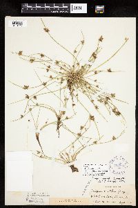 Schoenoplectus smithii var. smithii (A. Gray) Soj 292006[1021757]Hotchkiss, N.; Jones, Percy 41411930-09-13 United States, Minnesota, Ramsey, White Bear Lake.;;030N;22W;, 45.079894 -93.045502 |
MIN:Plants | 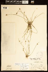 297594[1285278]Rosendahl, C. 61251929-09-17 United States, Minnesota, Washington, SW end of Forest Lake.;;032N;21W;, 45.253532 -92.958232 |
MIN:Plants | 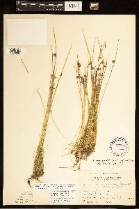 Schoenoplectus smithii var. setosus (Fernald) S.G. Smith 307319[1285253]Grant, M. L. 67721935-09-06 United States, Minnesota, Clearwater, Mink Lake. SE-SE of section;Itasca State Park;143N;36W;07, 47.216898 -95.286535 |
MIN:Plants | 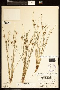 Schoenoplectus smithii var. setosus (Fernald) S.G. Smith 345907[1285261]Lakela, Olga 22901937-08-26 United States, Minnesota, Saint Louis, Oatka Beach Addition. Duluth.;;;;, 46.7833 -92.1 |
MIN:Plants |  359929[1285273]Rosendahl, C. O. 67351936-08-31 United States, Minnesota, Pine, north end of Sturgeon Lake;;045N;19W;, 46.374946 -92.7409 |
MIN:Plants |  364996[1285275]Buell, Murray 20141940-08-17 United States, Minnesota, Clearwater, beaver dam 1/4 mi W. of Lyndecker Lake;Itasca State Park;143N;36W;, 47.19557 -95.233216 |
MIN:Plants |  Schoenoplectus smithii var. setosus (Fernald) S.G. Smith 368130[1021756]Delaney, B. s.n.1988-09-05 United States, Minnesota, Anoka, Fish Lake on the east side.;Cedar Creek National History Area;034N;23W;25, 45.406738 -93.152624 |
MIN:Plants |  Schoenoplectus smithii var. setosus (Fernald) S.G. Smith 370697[1285257]Moore, John W. 137101940-10-01 United States, Minnesota, Isanti, West shore of lake, east of Highway 65. N.E1/4;;035N;23W;08, 45.536457 -93.23522 |
MIN:Plants |  371105[1285269]Moore, John W. 136751940-09-28 United States, Minnesota, Anoka, north shore of lake; N.W.1/4;;033N;23W;32, 45.305232 -93.235018 |
MIN:Plants |  Schoenoplectus smithii var. setosus (Fernald) S.G. Smith 433346[1285200]Myhre, Karen 61271995-08-18 United States, Minnesota, Aitkin, Directly northeast of Spirit Lake; Little Turtle Lake. NW1/4 of SW1/4 of section;;046N;26W;09, 46.482378 -93.632924 |
MIN:Plants |  Schoenoplectus purshianus var. purshianus (Fernald) M.T. Strong 439423[1105558]Myhre, K. 30881992-08-14 United States, Minnesota, Cass, Cass County ... Located one mile northwest of Lake Ada ... T139N R29W NE1/4 of NW1/4 of Sec 21;;139N;29W;21, 46.841876 -94.352798 |
MIN:Plants |  Schoenoplectus purshianus var. purshianus (Fernald) M.T. Strong 440369[1021749]Myhre, K. 30161992-08-11 United States, Minnesota, Cass, Chippewa National Forest / Leech Lake Indian Reservation. Cass County ... Located one half mile southeast of Pike Bay in Cass Lake Camp Lake ... T145N R31W SW1/4 of SE1/4 of Sec.36. 145N 31W 36, 47.330789 -94.554707 |
MIN:Plants |  Schoenoplectus smithii var. smithii (A. Gray) Soj 440786[1285254]Aiton, George B. s.n.1890-08-00 United States, Minnesota, Hennepin, Lake Minnetonka;;;;, 44.924201 -93.595343 |
MIN:Plants | 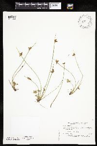 Schoenoplectus purshianus var. purshianus (Fernald) M.T. Strong 440806[1021748]Myhre, K. 32321992-08-31 United States, Minnesota, Cass, Cass County ... Located on the west shore of Spider Lake ... T137N R32W NW1/4 of NE1/4 of sec 24.;Foothills State Forest;137N;32W;24, 46.666344 -94.670409 |
MIN:Plants | 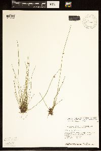 Schoenoplectus smithii var. setosus (Fernald) S.G. Smith 458826[1285263]Smith, Welby R. 147121988-08-04 United States, Minnesota, Benton, About 5 miles due east of Rice; small lake. SE1/4 SE1/4;Wisneski Wildlife Area;038N;30W;30, 45.7533333 -94.1166667 |
MIN:Plants | 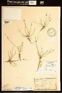 Schoenoplectus smithii var. setosus (Fernald) S.G. Smith 461582[1285260]Taylor, B. C. T16271892-08-00 United States, Minnesota, Chisago, Center City;;034N;20W;, 45.42608 -92.83619 |
MIN:Plants | 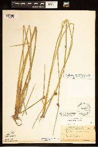 536167[1285270]Hale, T. F. s.n. United States, Minnesota, Hennepin, Minneapolis;;;;, 44.98 -93.26361 |
MIN:Plants |  Schoenoplectus smithii var. setosus (Fernald) S.G. Smith 568650[1285267]Moore, John W. 249361959-10-01 United States, Minnesota, Blue Earth, North shore of Lake Balyntine;;109N;25W;, 44.239469 -93.828345 |
MIN:Plants | 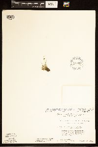 Schoenoplectus smithii var. setosus (Fernald) S.G. Smith 616784[1285266]Moore, John W. 5221969-09-26 United States, Minnesota, Crow Wing, Cranberry Bog Lake. S1/2 of SE1/4;Crow Wing Natural Area;044N;28W;29, 46.265142 -93.904498 |
MIN:Plants | 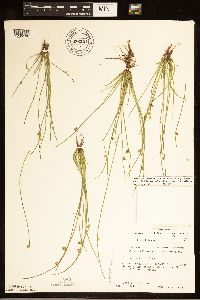 Schoenoplectus smithii var. setosus (Fernald) S.G. Smith 676321[1285196]Ownbey, Gerald B. 52151976-08-02 United States, Minnesota, Clearwater, Bohall Lake.;Itasca State Park;143N;36W;, 47.19557 -95.233216 |
MIN:Plants | 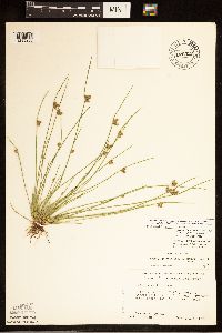 Schoenoplectus smithii var. setosus (Fernald) S.G. Smith 676322[1285203]Ownbey, Gerald B. 52481976-08-06 United States, Minnesota, Clearwater, Mink Lake, NW corner. SE1/4 of section;Itasca State Park;143N;36W;07, 47.216898 -95.286535 |
MIN:Plants | 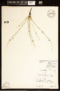 Schoenoplectus smithii var. setosus (Fernald) S.G. Smith 676323[1285252]Ownbey, Gerald B. 52611976-08-11 United States, Minnesota, Hubbard, Lake Alice Bog, about 2 mi due E of Alice Lake. SW1/4 of section;;143N;34W;06, 47.232109 -95.036236 |
MIN:Plants |  Schoenoplectus purshianus var. purshianus (Fernald) M.T. Strong 687530[1021752]Wheeler, Gerald; Glaser, Paul 19721977-07-09 United States, Minnesota, Itasca, Itasca County ... Coll. Site 100 ... SE1/4 NW1/4 Sec. 30 T57N R25W; approx. 10.5 miles north of Grand Rapids ... north side of Bosely Lake ... lake just south of Highway 60.. 057N 25W 30, 47.393012 -93.567693 |
MIN:Plants |  Schoenoplectus smithii var. setosus (Fernald) S.G. Smith 687723[1285258]Wheeler, Gerald A. 21691977-07-20 United States, Minnesota, Itasca, Coll. Site No.131. Approx. 8.5 mi N-NW of Grand Rapids. NW1/4 NW1/4;;056N;26W;01, 47.362785 -93.587218 |
MIN:Plants |  Schoenoplectus purshianus var. purshianus (Fernald) M.T. Strong 687802[1021750]Wheeler, Gerald; Glaser, Paul 22481977-07-24 United States, Minnesota, Itasca, Itasca County ... Coll. Site 100 ... SE1/4 NW1/4 sec.30 T57N R25W; approx. 10.5 mi N of Grand Rapids ... north side of Bosely Lake ... the lake just south of Highway 60.. 057N 25W 30, 47.393012 -93.567693 |
MIN:Plants |  Schoenoplectus purshianus var. purshianus (Fernald) M.T. Strong 689857[1105557]Ownbey, Gerald 57811977-08-08 United States, Minnesota, Hubbard, Hubbard County ... Itasca State Park, W side of U.S. Rte.71, 2 mi N of its jct. with Minn. Rt. 113;Itasca State Park;143N;35W;, 47.195787 -95.107789 |
MIN:Plants | 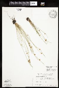 Schoenoplectus purshianus var. purshianus (Fernald) M.T. Strong 722281[1021751]Wheeler, Gerald 53251980-08-10 United States, Minnesota, Anoka, Anoka County ... Cooper's Lake. Approx. 1 mile east of Bethel ... north shore. T34N R23W Sec.30;;034N;23W;30, 45.406473 -93.255227 |
MIN:Plants | 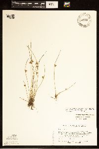 Schoenoplectus smithii var. setosus (Fernald) S.G. Smith 817119[1285199]Delaney, Barbara 892811989-08-24 United States, Minnesota, Isanti, On the N and NW side of the peninsula that protrudes into Horseshoe Lake from the south. SE1/4 SW1/4 of section;;034N;22W;02, 45.463224 -93.052381 |
MIN:Plants | 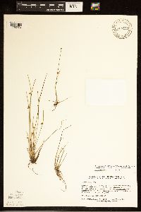 817127[1285276]Delaney, B. 893001989-08-25 United States, Minnesota, Isanti, Bog lake 2 mi NE of the crossroads known as Springvale, at the Springvale Campground. NW1/4 NE1/4;;036N;24W;01, 45.637605 -93.275954 |
MIN:Plants | 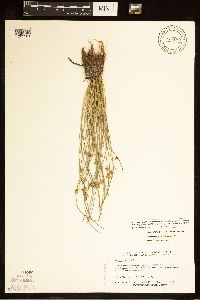 Schoenoplectus smithii var. setosus (Fernald) S.G. Smith 817180[1285201]Delaney, Barbara 891411989-08-07 United States, Minnesota, Isanti, Small lake, between Cambridge and Isanti on W side of railroad track. SE1/4 NW1/4 of section;;035N;23W;17, 45.521981 -93.23531 |
MIN:Plants |  83323[1285271]Sheldon, E. P. S.60911893-08-00 United States, Minnesota, Ramsey, Poplar Island Lake [poss. Island Lake in Shoreview?];;030N;23W;, 45.080032 -93.166927 |
MIN:Plants |  83453[1285272]MacMillan, Conway s.n.1890-08-00 United States, Minnesota, Crow Wing, Brainerd;;133N;28W;03, 46.34845 -94.24059 |
MIN:Plants |  83454[1285255]MacMillan, Conway M&S 151890-08-00 United States, Minnesota, Crow Wing, Brainerd;;133N;28W;03, 46.34845 -94.24059 |
MIN:Plants |  Schoenoplectus smithii var. smithii (A. Gray) Soj 83456[1285277]Sandberg, John s.n.1890-08-00 United States, Minnesota, Hennepin, [no further data];;;;, 45.004579 -93.476877 |
MIN:Plants |  Schoenoplectus smithii var. setosus (Fernald) S.G. Smith 838431[1285198]Myhre, Karen 45501993-08-25 United States, Minnesota, Pine, 3.3 mi NE of the town of Willow River; Rush Lake. SE1/4 of NE1/4 of section;;045N;19W;29, 46.353321 -92.772186 |
MIN:Plants |  Schoenoplectus smithii var. setosus (Fernald) S.G. Smith 839231[1285202]Myhre, Karen 44131993-08-08 United States, Minnesota, Pine, 6 mi northeast of the town of Bruno. SW1/4 of SE1/4 of section;;044N;17W;07, 46.309418 -92.541551 |
MIN:Plants |  Schoenoplectus subterminalis (Torrey) Soj 270933[1105588]Gunderson, Harvey s.n.1940-08-02 United States, Minnesota, Lake, Bessner Creek.;;N;;, 47.501209 -91.086919 |
MIN:Plants |  Schoenoplectus subterminalis (Torrey) Soj 306817[1105592]Moyle, J. 25271935-09-23 United States, Minnesota, Saint Louis, In a lake at the head of Dark Horse Creek.;;N;;, 47.575974 -92.179978 |
MIN:Plants |  Schoenoplectus subterminalis (Torrey) Soj 306818[1105593]Moyle, J. 2527 United States, Minnesota, Saint Louis, Lake at the head of Dark Horse Creek.;;N;;, 47.575974 -92.179978 |
MIN:Plants |  Schoenoplectus subterminalis (Torrey) Soj 306820[1105603]Moyle, J. 24131935-09-17 United States, Minnesota, Saint Louis, Bell Lake.;Kabetogama State Forest;065N;19W;, 48.108007 -92.775055 |
MIN:Plants |  Schoenoplectus subterminalis (Torrey) Soj 307310[1105599]Grant, Martin 67421935-09-03 United States, Minnesota, Clearwater, Itasca State Park. Squaw Lake.;Itasca State Park;143N;36W;5, 47.231426 -95.265784 |
MIN:Plants |  Schoenoplectus subterminalis (Torrey) Soj 336452[1105596]Reif, Charles A281936-07-10 United States, Minnesota, Cook, Brule River.;Judge Magney State Park / North Shore;062N;03E;, 47.849836 -90.064949 |
MIN:Plants |  Schoenoplectus subterminalis (Torrey) Soj 336499[1105587]Reif, Charles A211936-07-25 United States, Minnesota, Cook, Temperance River.;North Shore / Temperance River State Park;059N;04W;, 47.599359 -90.844189 |
MIN:Plants |  Schoenoplectus subterminalis (Torrey) Soj 338092[1105604]Moore, W. V5091936-07-20 United States, Minnesota, Lake, Spring Lake. Lake Co.;Superior National Forest;061N;10W;28, 47.740487 -91.608602 |
MIN:Plants |  Schoenoplectus subterminalis (Torrey) Soj 346743[1105595]Reif, Charles s.n.1936-07-10 United States, Minnesota, Cook, Brule River.;Judge Magney State Park / North Shore;062N;03E;, 47.849836 -90.064949 |
MIN:Plants |  Schoenoplectus subterminalis (Torrey) Soj 362070[1105591]Moyle, J. 34481940-08-02 United States, Minnesota, Lake, E Branch of the Baptism River.;Finland State Forest;057N;07W;00, 47.415173 -91.214898 |
MIN:Plants |  Schoenoplectus subterminalis (Torrey) Soj 369196[1105589]Gunderson, Harvey s.n.1940-08-02 United States, Minnesota, Lake, Blessner Creek.;;N;;, 47.501209 -91.086919 |
MIN:Plants |  Schoenoplectus subterminalis (Torrey) Soj 375222[1105578]Lakela, Olga 51521942-08-18 United States, Minnesota, Saint Louis, E shore of Half Moon Lake. 6 mi. N of Eveleth on hwy. 61.;;057N;17W;, 47.549278 -92.539906 |
MIN:Plants |  Schoenoplectus subterminalis (Torrey) Soj 379213[1105598]Lakela, Olga 53821943-08-10 United States, Minnesota, Saint Louis, SE shore of Half Moon Lake, hwy. 53, 6 mi. S of Eveleth.;;057N;17W;, 47.415502 -92.495535 |
MIN:Plants |  Schoenoplectus subterminalis (Torrey) Soj 415436[1105605]Fassett, N. 280881949-08-16 United States, Minnesota, Clearwater, Itasca State Park. Squaw Lake near "Rest Camp".;Itasca State Park;143N;36W;5, 47.231426 -95.265784 |
MIN:Plants |  Schoenoplectus subterminalis (Torrey) Soj 421654[1105590]Ahlgren, Clifford 10941950-08-22 United States, Minnesota, Saint Louis, In a bay 1/4 mi. SW of Curtain Falls, Crooked Lake.;Boundary Waters Canoe Area Wilderness / Superior National Forest;N;;, 48.186787 -91.869968 |
MIN:Plants |  Schoenoplectus subterminalis (Torrey) Soj 428337[1105585]Smith, Welby 138801987-08-16 United States, Minnesota, Lake, Lake County...In the BWCAW, Superior National Forest...Kawishiwi River...NE1/4 SE1/4 setion 8, T62N R6W;Boundary Waters Canoe Area Wilderness / Superior National Forest;062N;06W;08, 47.868402 -91.118625 |
MIN:Plants |  Schoenoplectus subterminalis (Torrey) Soj 430423[1105580]Scott, P. 8271995-08-14 United States, Minnesota, Cook, Cook Co. Poplar Creek T64N R1W sec.16;Superior National Forest;064N;01W;16, 48.027587 -90.460168 |
MIN:Plants |  Schoenoplectus subterminalis (Torrey) Soj 433065[1105569]Myhre, K.; Converse, C. 60921995-08-15 United States, Minnesota, Aitkin, Aitkin Co.; Located 2.5 miles northeast of Glory; small bog lake; T 46N R 26W NW1/4 of SE1/4 of Sec 24;;046N;26W;24, 46.45324 -93.569307 |
MIN:Plants |  Schoenoplectus subterminalis (Torrey) Soj 439660[1021762]Myhre, K. 45791993-08-31 United States, Minnesota, Pine, Pine Co. Located 1 mi E of the town of Willow River; NE bay of First Lake; T44N R20W SE1/4 of SW1/4 of SEc 1;;044N;20W;1, 46.32412 -92.813901 |
MIN:Plants |  Schoenoplectus subterminalis (Torrey) Soj 440163[1105567]Myhre, K. 46711993-09-19 United States, Minnesota, Pine, Pine Co. Located 23 mi NE of the town of Hickley [sic]; SW shore of Greigs Lake; T41N R17W SE1/4 of NE1/4 of Sec 10;;041N;17W;10, 46.048527 -92.477727 |
MIN:Plants |  Schoenoplectus subterminalis (Torrey) Soj 443451[1105607]Myhre, K. 51951994-07-21 United States, Minnesota, Itasca, Itasca Co.; Located one quarter mile west of Pigeon Dam Lake; T 147N R 28W SE1/4 of SE1/4 of Sec 24;Chippewa National Forest / Leech Lake Indian Reservation;147N;28W;24, 47.531191 -94.171262 |
MIN:Plants |  Schoenoplectus subterminalis (Torrey) Soj 445310[1105611]Myhre, K. 58211995-07-04 United States, Minnesota, Aitkin, Aitkin Co.; Located one mile southeast of the town of Glen; Sugar Lake; T 45N R 25W SE1/4 of NW1/4 of Sec 2;;045N;25W;2, 46.412527 -93.462325 |
MIN:Plants |  Schoenoplectus subterminalis (Torrey) Soj 453617[1105582]Myhre, K. 62761995-09-14 United States, Minnesota, Aitkin, Savanna State Forest. Aitkin Co. Located 1/2 mi W of Savana [sic] Portage State Park. Plant occur along the shores of Remote Lake; T50N R23W S Aitkin Co. Located 1/2 mi W of Savana [sic] Portage State Park. Plant occur along the shores of Remote Lake; T50N R23W SE1/4 of SE1/4 of sec 11. 050N 23W 11, 46.831792 -93.22126 |
MIN:Plants |  Schoenoplectus subterminalis (Torrey) Soj 457215[1021760]Smith, Welby 211521992-07-30 United States, Minnesota, Cass, Cass County...about 11 miles east-southeast of Hackensack. In a small unnamed lake (about 10 acres) between Black Water Lake and Little Mule Lake...T 140N R 29W NE1/4 of NW1/4 of Sec. 36. 140N 29W 36, 46.9044444 -94.2916667 |
MIN:Plants |  Schoenoplectus subterminalis (Torrey) Soj 457309[1105568]Myhre, K. 5167A1994-07-05 United States, Minnesota, Itasca, Itasca Co.; located 2.7 miles southwest of the town of Bigfork; small bog lake; T 60N R 26W SW1/4 of SW1/4 of Sec 5;Chippewa National Forest;060N;26W;5, 47.713566 -93.673252 |
MIN:Plants |  Schoenoplectus subterminalis (Torrey) Soj 459433[1105562]Myhre, K. 45491993-08-25 United States, Minnesota, Pine, Pine Co. Located 3.3 mi NE of the town of Willow River; Rush Lake; T45N R19W SE1/4 of NE1/4 of Sec 29;;045N;19W;29, 46.353321 -92.772186 |
MIN:Plants |  Schoenoplectus subterminalis (Torrey) Soj 475510[1105570]Cholewa, A. 25821999-08-02 United States, Minnesota, Clearwater, Itasca State Park. Clearwater Co, Itasca State Park, Ozawindib Lake, between island and southeast shore. T143NR36W, NW1/4 of SE1/4 of SW1/ Clearwater Co, Itasca State Park, Ozawindib Lake, between island and southeast shore. T143NR36W, NW1/4 of SE1/4 of SW1/4 of sec.5.. 143N 36W 5, 47.229066 -95.272922 |
MIN:Plants |  Schoenoplectus subterminalis (Torrey) Soj 476327[1105610]Myhre, K. 32551992-09-02 United States, Minnesota, Cass, Cass Co.; north shore of Camp Lake; northwest bay; T 140N R 27W SE1/4 of NW1/4 of sec 30;;140N;27W;30, 46.912765 -94.144072 |
MIN:Plants |  Schoenoplectus subterminalis (Torrey) Soj 506088[1105566]Myhre, K. 45301993-08-19 United States, Minnesota, Pine, Pine Co. Located 1 mi SE of the town of Willow River; E half of Second Lake; T44N R19W SW1/4 of NW1/4 of sEc 7;;044N;19W;7, 46.309615 -92.793173 |
MIN:Plants |  Schoenoplectus subterminalis (Torrey) Soj 514447[1105563]Myhre, K. 30621992-08-14 United States, Minnesota, Cass, Cass Co.; located 1/4 mi SW of Blackwater Lake; N shore of Island Lake; T140N R29W NE1/4 of SE1/4 of Sec 34;;140N;29W;34, 46.899245 -94.331608 |
MIN:Plants |  Schoenoplectus subterminalis (Torrey) Soj 525833[1105575]Lakela, Olga 190511955-08-03 United States, Minnesota, Saint Louis, The outlet river from Johnson's Lake to Namakan Lake.;Voyageurs National Park;018N;68W;, 48.35579 -92.60033 |
MIN:Plants |  Schoenoplectus subterminalis (Torrey) Soj 527034[1105586]Lakela, Olga 182391954-08-14 United States, Minnesota, Saint Louis, Turtle River, S of Friday Bay of Crooked Lake.;Boundary Waters Canoe Area Wilderness / Superior National Forest;N;;, 48.167528 -91.806553 |
MIN:Plants |  Schoenoplectus subterminalis (Torrey) Soj 541531[1105576]Morley, T. 9381957-08-18 United States, Minnesota, Hubbard, Deming Pond, in Itasca State Park, NE across the park entrance road from Deming Lake. N-NW shore of the pond.;Itasca State Park;143N;35W;, 47.195787 -95.107789 |
MIN:Plants |  Schoenoplectus subterminalis (Torrey) Soj 578729[1105606]Ownbey, Gerald 32271962-07-14 United States, Minnesota, Becker, White Earth Indian Reservation / White Earth State Forest. Becker Co. Near hwy. 113, 8.5 mi. W of the jct. with hwy. 71. Shallow Lake (the farthest W of the two present here), S Becker Co. Near hwy. 113, 8.5 mi. W of the jct. with hwy. 71. Shallow Lake (the farthest W of the two present here), S side of the highway.. 142N 37W 1, 47.144396 -95.307886 |
MIN:Plants |  Schoenoplectus subterminalis (Torrey) Soj 590417[1105608]Ownbey, Gerald 38491965-08-21 United States, Minnesota, Clearwater, 1.2 mi. SE of Roy Lake. On the S side of Rte. 31.;White Earth Indian Reservation;144N;38W;, 47.281836 -95.487753 |
MIN:Plants |  Schoenoplectus subterminalis (Torrey) Soj 603595[1021765]Moore, John 269681966-08-03 United States, Minnesota, Isanti, Beckman Lake, Cedar Creek Natural History Area.;Cedar Creek National History Area;143N;36W;, 45.424513 -93.186602 |
MIN:Plants |  Schoenoplectus subterminalis (Torrey) Soj 687730[1105600]Wheeler, Gerald; Glaser, Paul 21771977-07-21 United States, Minnesota, Itasca, Ca. 8.5 mi. N-NW of Grand Rapids.;;056N;26W;1, 47.362785 -93.587218 |
MIN:Plants |  Schoenoplectus subterminalis (Torrey) Soj 738127[1105601]Monson, Paul 51171971-08-27 United States, Minnesota, Lake, Lake Co. T-62N R-6W S-9. In a slow-moving river flowing into Kawasachong Lake.;Boundary Waters Canoe Area Wilderness / Superior National Forest;062N;06W;09, 47.868432 -91.097035 |
MIN:Plants |  Schoenoplectus subterminalis (Torrey) Soj 774428[1105583]Monson, Paul 5746B1983-08-03 United States, Minnesota, Saint Louis, Namakan Lake, Sheen Point, Channel adjacent to McManus Island.;Voyageurs National Park;069N;18W;31, 48.419055 -92.691347 |
MIN:Plants |  Schoenoplectus subterminalis (Torrey) Soj 781145[1021764]Smith, Welby 98791984-08-13 United States, Minnesota, Clearwater, Itasca State Park. At the S end of Squaw Lake.;Itasca State Park;143N;36W;5, 47.231426 -95.265784 |
MIN:Plants |  Schoenoplectus subterminalis (Torrey) Soj 789765[1021763]Smith, Welby 109491985-07-31 United States, Minnesota, Beltrami, S end of Grass Lake, ca. 2 mi. W of Bemidji.;;146N;34W;1, 47.491413 -94.937918 |
MIN:Plants |  Schoenoplectus subterminalis (Torrey) Soj 830317[1105581]Delaney, B. 912601991-08-16 United States, Minnesota, Morrison, Morrison Co.; 3 mi SE of Sullivan Lake. NE1/4 NW1/4 sec.28, T42N, R28W.;;042N;28W;28, 46.091944 -93.883169 |
MIN:Plants |  Schoenoplectus subterminalis (Torrey) Soj 833718[1105612]Monson, Paul 45331964-08-19 United States, Minnesota, Becker, Becker Co. R-37, T-142, S-2. Large pond on S sd. of Hwy 113, 8.5 mi W of jnc. with Hwy 71;White Earth Indian Reservation / White Earth State Forest;142N;37W;2, 47.144361 -95.32919 |
Google Map
Google Maps is a web mapping service provided by Google that features a map that users can pan (by dragging the mouse) and zoom (by using the mouse wheel). Collection points are displayed as colored markers that when clicked on, displays the full information for that collection. When multiple species are queried (separated by semi-colons), different colored markers denote each individual species.