University of Minnesota
http://www.umn.edu/
612-625-5000
http://www.umn.edu/
612-625-5000
Minnesota Biodiversity Atlas
Bell Museum
Dataset: MIN-Plants
Taxa: Selaginellaceae
Search Criteria: excluding cultivated/captive occurrences
Bell Museum plants | |
 MIN:Plants |  Selaginella rupestris (L.) Spring 510719[1311472]Wheeler, Gerald 195881999-05-14 United States, Minnesota, Pipestone, Pipestone County ... NW edge of Pipestone; Hiawatha State Game Refuge ... N1/2 NW1/4 Sec. 1 T106N R46W (Sweet 1);Pipestone Wildlife Management Area;106N;46W;1, 44.01585 -96.31767 |
MIN:Plants |  Selaginella rupestris (L.) Spring 435957[1311470]Wheeler, Gerald 159251997-06-06 United States, Minnesota, Brown, Brown Co.; Ca. 15 mi. NW of Sleepy Eye, 0.4 mi. NE of Rte. 10, Morgan Sportsman Club Recreation Area; SW1/4 NE1/4 SW1/4 Sec. 19 T112N R33W (Eden 19). 112N 33W 19, 44.48977 -94.859528 |
MIN:Plants | Selaginella rupestris (L.) Spring 220346[]Cooper, William 731909-07-10 United States, Michigan, Keweenaw, Rock Harbor, Isle Royale;Isle Royale National Park |
MIN:Plants |  Selaginella rupestris (L.) Spring 923319[1383807]Smith, Welby 214521992-08-12 United States, Minnesota, Marshall, About 11 miles east of Argyle. NW1/4 of SE1/4 of section.;Old Mill State Park;156N;46W;04, 48.3602778 -96.5702778 |
MIN:Plants |  Selaginella rupestris (L.) Spring 928622[1383893]Gudmundson, Barbara 1881965-06-02 United States, Minnesota, Brown, Stately Township; Hagemann Prairie Falls, eastern falls. NW1/4 of SE1/4 of section.;;108N;35W;31, 44.113437 -95.087812 |
MIN:Plants | 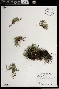 Selaginella rupestris (L.) Spring 921444[1383770]Perry, Ethan 100062010-08-08 United States, Minnesota, Lake, 4.5 miles SW of NE corner of Lake County, 85 meters E of Cherry Lake...T65N R6W SE1/4 of SW1/4 of Sec3;Boundary Waters Canoe Area Wilderness / Superior National Forest;065N;06W;03, 48.1383333 -91.0911111 |
MIN:Plants | 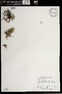 Selaginella rupestris (L.) Spring 921763[1383771]Perry, Ethan 100112010-05-14 United States, Minnesota, Saint Louis, 1.6 miles NW of the Gary neighborhood of Duluth, 0.5 miles S of Skyline Parkway, at ski trail overlook of Ely's Peak...T49N R15W SE1/4 of NW1/4 of Sec33. 049N 15W 33, 46.6852778 -92.2508333 |
MIN:Plants | 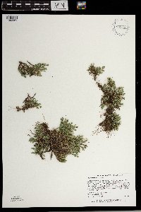 Selaginella rupestris (L.) Spring 931622[1383864]Lee, Michael MDL45832008-06-06 United States, Minnesota, Benton, Along U.S. Highway 10 just north of Watab, five miles south-southeast of Rice, six miles north of Sauk Rapids. On east side of the highway. SE1/4 of NW1/4 of NW1/4 of section;;037N;31W;23, 45.6877599 -94.170836 |
MIN:Plants | 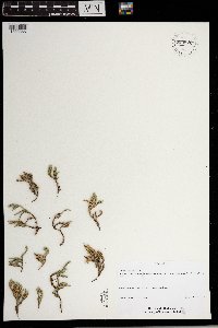 Selaginella rupestris (L.) Spring 933820[1383865]Schimpf, D. DJS6902012-07-23 United States, Minnesota, Saint Louis, Midway Township. Ely's Peak. ;<No data>;049N;15W;33, 46.6788889 -92.2520833 |
MIN:Plants |  Selaginella rupestris (L.) Spring 959310[1311152]Lynden B. Gerdes 54172007-06-20 United States, Minnesota, Lake, Superior National Forest. Approximately 10.27 miles east of Babbitt, MN and 0.06 miles east of Sue Lake., 47.726421 -91.716372 |
MIN:Plants |  Selaginella rupestris (L.) Spring 959312[1311154]Lynden B. Gerdes 54182007-06-20 United States, Minnesota, Lake, Superior National Forest. Approximately 10.37 miles east of Babbitt, MN and 0.15 miles east of Sue Lake., 47.726421 -91.716372 |
MIN:Plants |  Selaginella rupestris (L.) Spring 959068[1305295]Lynden B. Gerdes 54232007-06-20 United States, Minnesota, Lake, Superior National Forest. Approximately 9.96 miles east of Babbitt, MN and 0.34 miles south of Sue Lake. Large, perched rock outcrop / woodland immediately east of FR 428., 47.726421 -91.716372 |
MIN:Plants |  Selaginella rupestris (L.) Spring 959313[1311155]Lynden B. Gerdes 54752007-07-11 United States, Minnesota, Lake, Superior National Forest. Approximately 10.30 miles SE of Ely, MN and 1.22 miles SW of Highway 1., 47.784324 -91.715672 |
MIN:Plants |  Selaginella rupestris (L.) Spring 959315[1311157]Lynden B. Gerdes 54772007-07-11 United States, Minnesota, Lake, Superior National Forest. Approximately 10.13 miles SE of Ely, MN and 1.24 miles SW of Highway 1., 47.784324 -91.715672 |
MIN:Plants |  Selaginella rupestris (L.) Spring 959302[1311144]Lynden B. Gerdes 54822007-07-12 United States, Minnesota, Lake, Superior National Forest. Approximately 10.60 miles SE of Ely, MN and 1.50 miles SW of Highway 1., 47.769901 -91.716186 |
MIN:Plants |  Selaginella rupestris (L.) Spring 959301[1311143]Lynden B. Gerdes 56622008-08-18 United States, Minnesota, Lake, Superior National Forest. Boundary Waters Canoe Area Wilderness. Horse Lake., 48.06666667 -91.76222222 |
MIN:Plants |  Selaginella rupestris (L.) Spring 959067[1305294]Lynden B. Gerdes 56882008-08-25 United States, Minnesota, Lake, Superior National Forest. Boundary Waters Canoe Area Wilderness. Tin Can Mike Lake. Near campsite at northwest end of lake., 48.05666667 -91.77138889 |
MIN:Plants |  Selaginella rupestris (L.) Spring 959069[1305296]Lynden B. Gerdes 58162009-07-24 United States, Minnesota, Cook, Superior National Forest. Boundary Waters Canoe Area Wilderness. Western shores of Gillis Lake; on the mainland just north of the large island., 48.055977 -90.928672 |
MIN:Plants |  Selaginella rupestris (L.) Spring 959071[1305298]Lynden B. Gerdes 61582010-08-04 United States, Minnesota, Lake, Superior National Forest. BWCAW. Near portage between Hanson Lake and Cherry Lake., 48.14194444 -91.08722222 |
MIN:Plants |  Selaginella rupestris (L.) Spring 959311[1311153]Lynden B. Gerdes 67472012-08-21 United States, Minnesota, Lake, Superior National Forest. BWCAW. Gibson Lake. Near the western landing of the Gibson Lake and Cattyman Lake portage., 48.01583333 -91.32166667 |
MIN:Plants |  Selaginella rupestris (L.) Spring 959299[1311141]Lynden B. Gerdes 68602013-07-23 United States, Minnesota, Lake, Superior National Forest. Stony River, approximately 7.94 miles east of Babbitt, MN and 0.08 miles west of river., 47.70861111 -91.76 |
MIN:Plants |  Selaginella rupestris (L.) Spring 959303[1311145]Lynden B. Gerdes 70202014-06-11 United States, Minnesota, Saint Louis, Superior National Forest. Approximately 9.57 miles east of Buyck, MN and 0.14 miles southeast of Nigh Lake. Circa the Astrid Lake hiking trail., 48.11944444 -92.31666667 |
MIN:Plants |  Selaginella rupestris (L.) Spring 959305[1311147]Lynden B. Gerdes 70652014-06-26 United States, Minnesota, Saint Louis, Superior National Forest. Approximately 2.47 miles SE of Crane Lake, MN and 0.49 miles west of Knute Lake - BWCAW., 48.24861111 -92.44138889 |
MIN:Plants |  Selaginella rupestris (L.) Spring 959307[1311149]Lynden B. Gerdes 71602014-08-01 United States, Minnesota, Saint Louis, Superior National Forest, Lake Agnes, BWCAW. Large bedrock outcrop complex southeast of lake., 48.20277778 -92.03527778 |
MIN:Plants |  Selaginella rupestris (L.) Spring 959440[1311271]Lynden B. Gerdes 72792015-07-01 United States, Minnesota, Saint Louis, Superior National Forest. Approximately 15.61 miles east of Ray, MN and 0.47 miles south of the Ash River Trail (County Road 129)., 48.38805556 -92.86555556 |
MIN:Plants |  Selaginella rupestris (L.) Spring 959426[1311257]Lynden B. Gerdes 73842015-08-25 United States, Minnesota, Saint Louis, Superior National Forest. Fenske Lake, approximately 6.80 miles NNW of Ely, MN. North shore of lake approximately 0.70 miles SE of the boat landing., 47.99333333 -91.90277778 |
MIN:Plants |  Selaginella rupestris (L.) Spring 959297[1311139]Gerdes, Lynden B. 54762007-07-11 United States, Minnesota, Lake, Superior National Forest. Approximately 10.30 miles SE of Ely, MN and 1.22 miles SW of Highway 1. T61N R11W S10SESW, 47.784324 -91.715672 |
MIN:Plants |  Selaginella rupestris (L.) Spring 959884[1318181]Anderson, Chel E. 24622017-09-02 United States, Minnesota, Koochiching, About 40 miles W of International Falls in Franz Jevne State Park., 48.64 -94.07 |
MIN:Plants |  Selaginella rupestris (L.) Spring 960717[1329322]Lee, Michael MDL32332002-08-19 United States, Minnesota, Olmsted, Along the North Fork Whitewater River 3/4-mile downstream from the mouth of the Logan Branch, five miles southeast of Plainview. S1/2 of NW1/4 of SW1/4 Sec. 2, Whitewater Wildlife Management Area, 44.097051 -92.11677 |
MIN:Plants |  Selaginella rupestris (L.) Spring 967977[1368540]T. J. S. Whitfeld 22252019-06-20 United States, Minnesota, Lake, Boundary Waters Canoe Area Wilderness, 0.2 miles north of Tornado Lake, in area burned during 2011 Pagami Creek fire, 47.8845 -91.292806, 472m |
MIN:Plants |  Selaginella rupestris (L.) Spring 961193[1334668] United States, Maine |
MIN:Plants |  Selaginella rupestris (L.) Spring 962786[1346411]Dahlberg, Nathan B. NBD982018-08-11 United States, Minnesota, Cook, Superior National Forest, 0.81mi East of Forest rd 158; 1.55mi north of Devil Track rd; 11.23mi northwest of Grand Marais., 47.85 -90.53 |
MIN:Plants |  Selaginella rupestris (L.) Spring 964739[1375687]Lee, Michael MDL49632009-06-29 United States, Minnesota, Sherburne, George Friedrich Park, On the southeast side of St. Cloud. T35N R30W NE1/4 of SW1/4 Sec. 6, 45.55017857 -94.12254736 |
MIN:Plants |  Selaginella rupestris (L.) Spring 965309[1375978]Lee, Michael MDL52462010-07-09 United States, Minnesota, Cook, Boundary Waters Canoe Area Wilderness, Rugged bedrock terrain in the Misquah Hills, 17 miles north-northwest of Grand Marais.T64N R1W NW1/4 of SE1/4 Sec. 32, 47.98199785 -90.47774603, 632m |
MIN:Plants |  Selaginella rupestris (L.) Spring 965380[1356243]Lee, Michael MDL53212010-07-26 United States, Minnesota, Cook, Boundary Waters Canoe Area Wilderness, Rolling to moderately rugged bedrock terrain 24 miles northwest of Grand Marais. T64N R3W S1/2 of SW1/4 of NW1/4 Sec. 22, 48.01212742 -90.69897627, 594m |
MIN:Plants |  Selaginella rupestris (L.) Spring 966958[1359649]Dahlberg, Nathan B. NBD1862019-08-09 United States, Minnesota, Lake, Superior National Forest. 580m NE of T-243, 2606m S of T-226, 10.96 miles from Babbitt;, 47.75 -91.72 |
MIN:Plants |  Selaginella rupestris (L.) Spring 968915[1391585]Milburn, Scott 202020-08-25 United States, Minnesota, Lake, Located 0.52km due east of Birch Lake., 47.779789 -91.753249 |
MIN:Plants |  Selaginella rupestris (L.) Spring 969066[1391733]Rowe, Erika R. ERR9202016-08-03 United States, Minnesota, Roseau, Beltrami Island State Forest. 150 meters northwest of Tangnes Forest Rd; 3.9 miles south of MN Trunk Hwy 11; 11 miles southeast of Warroad., 48.78 -95.17 |
MIN:Plants |  Selaginella rupestris (L.) Spring 262255[1372290] United States, Wisconsin |
MIN:Plants |  Selaginella rupestris (L.) Spring 423231[1372291] United States, Arkansas |
MIN:Plants |  Selaginella rupestris (L.) Spring 55563[1372292] United States, Florida |
MIN:Plants |  Selaginella rupestris (L.) Spring 528502[1372293] Canada, Ontario |
MIN:Plants |  Selaginella rupestris (L.) Spring 55561[1372294] United States, District of Columbia |
MIN:Plants |  Selaginella rupestris (L.) Spring 386612[1372295] Canada, Ontario |
MIN:Plants |  Selaginella rupestris (L.) Spring 356488[1372296] United States, North Carolina |
MIN:Plants |  Selaginella rupestris (L.) Spring 55566[1372297] United States, North Carolina |
MIN:Plants |  Selaginella rupestris (L.) Spring 376898[1372298] United States, Wisconsin |
MIN:Plants |  Selaginella rupestris (L.) Spring 366414[1372299] United States, Wisconsin |
MIN:Plants |  Selaginella rupestris (L.) Spring 55578[1372300] United States, Washington |
MIN:Plants | 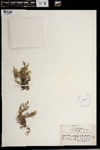 Selaginella rupestris (L.) Spring 423543[1372301] United States, Wisconsin |
MIN:Plants | 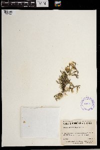 Selaginella rupestris (L.) Spring 424747[1372302] Canada, Quebec |
MIN:Plants | 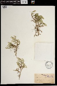 Selaginella rupestris (L.) Spring 55559[1372303] United States, Tennessee |
MIN:Plants | 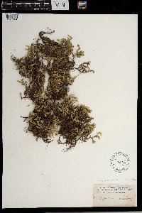 Selaginella rupestris (L.) Spring 55564[1372304] United States, Pennsylvania |
MIN:Plants | 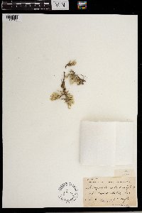 Selaginella rupestris (L.) Spring 55572[1372305] United States, Wisconsin |
MIN:Plants | 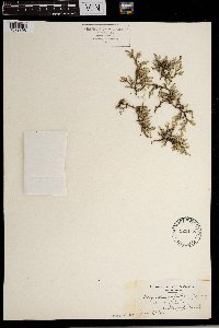 Selaginella rupestris (L.) Spring 523118[1372306] United States, Michigan |
MIN:Plants | 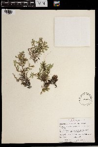 Selaginella rupestris (L.) Spring 536425[1372307] Canada, Ontario |
MIN:Plants | 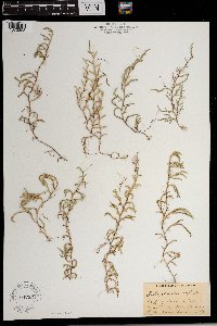 Selaginella rupestris (L.) Spring 764235[1372308] Canada |
MIN:Plants | 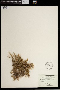 Selaginella rupestris (L.) Spring 558695[1372309] United States, Arizona |
MIN:Plants | 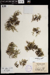 Selaginella rupestris (L.) Spring 388213[1372310] United States, Wisconsin |
MIN:Plants | 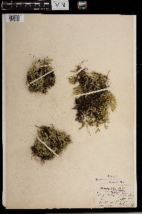 Selaginella rupestris (L.) Spring 55571[1372311] United States, Tennessee |
MIN:Plants | 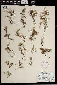 Selaginella rupestris (L.) Spring 356528[1372312] United States, South Carolina |
MIN:Plants |  Selaginella rupestris (L.) Spring 593814[1372313] United States, Missouri |
MIN:Plants |  Selaginella rupestris (L.) Spring 452514[1372314] United States, Missouri |
MIN:Plants |  Selaginella rupestris (L.) Spring 55568[1372315] United States, Massachusetts |
MIN:Plants |  Selaginella rupestris (L.) Spring 490749[1372316] Canada, Ontario |
MIN:Plants |  Selaginella rupestris (L.) Spring 55570[1372317] United States, Virginia |
MIN:Plants |  Selaginella rupestris (L.) Spring 55565[1372318] United States, Florida |
MIN:Plants |  Selaginella rupestris (L.) Spring 337236[1372319] United States, Maine |
MIN:Plants |  Selaginella rupestris (L.) Spring 267544[1372320] Canada, Quebec |
MIN:Plants |  Selaginella rupestris (L.) Spring 414247[1372321] United States, Wisconsin |
MIN:Plants |  Selaginella rupestris (L.) Spring 354985[1372322] United States, Wisconsin |
MIN:Plants |  Selaginella rupestris (L.) Spring 55573[1372323] United States, Wisconsin |
MIN:Plants |  Selaginella rupestris (L.) Spring 388212[1372324] United States, Wisconsin |
MIN:Plants |  Selaginella rupestris (L.) Spring 388210[1372325] United States, Wisconsin |
MIN:Plants |  Selaginella rupestris (L.) Spring 388214[1372326] United States, Wisconsin |
MIN:Plants |  Selaginella rupestris (L.) Spring 55549[1372327] United States, Minnesota |
MIN:Plants |  Selaginella rupestris (L.) Spring 556378[1372328] Canada, Ontario |
MIN:Plants | 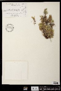 Selaginella rupestris (L.) Spring 556386[1372329] Canada, Ontario |
MIN:Plants | 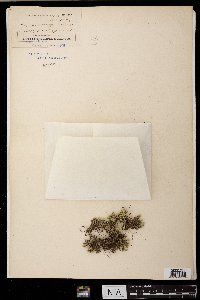 Selaginella rupestris (L.) Spring 55575[1372330] United States, Indiana |
MIN:Plants | 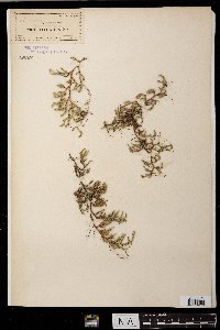 Selaginella rupestris (L.) Spring 55567[1372331] United States, Tennessee |
MIN:Plants | 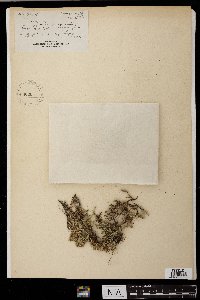 Selaginella rupestris (L.) Spring 55569[1372332] United States, Wisconsin |
MIN:Plants |  Selaginella rupestris (L.) Spring 538356[1372333] Canada, Ontario |
MIN:Plants |  Selaginella rupestris (L.) Spring 541147[1372334] Canada |
MIN:Plants |  Selaginella rupestris (L.) Spring 601423[1372335] United States, Kansas |
MIN:Plants |  Selaginella rupestris (L.) Spring 601412[1372336] United States, Nebraska |
MIN:Plants |  Selaginella rupestris (L.) Spring 601332[1372337] United States, South Dakota |
MIN:Plants |  Selaginella rupestris (L.) Spring 556377[1372338] Canada, Ontario |
MIN:Plants |  Selaginella rupestris (L.) Spring 593169[1372339] United States, Iowa |
MIN:Plants |  Selaginella rupestris (L.) Spring 594973[1372340] Canada, Ontario |
MIN:Plants |  Selaginella rupestris (L.) Spring 240127[1372351] United States, California |
MIN:Plants |  Selaginella rupestris (L.) Spring 240129[1372352] United States, California |
MIN:Plants |  Selaginella rupestris (L.) Spring 570594[1372356] Canada, Quebec |
MIN:Plants |  Selaginella rupestris (L.) Spring 618144[1372357] United States, Iowa |
MIN:Plants |  Selaginella rupestris (L.) Spring 433736[1372358] United States, West Virginia |
MIN:Plants |  Selaginella rupestris (L.) Spring 621329[1372359] United States, North Carolina |
MIN:Plants |  Selaginella rupestris (L.) Spring 55562[1372360] United States, New York |
MIN:Plants |  Selaginella rupestris (L.) Spring 558065[1372361] United States, North Dakota |
MIN:Plants | 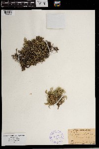 Selaginella rupestris (L.) Spring 388215[1372362] United States, New Hampshire |
MIN:Plants | 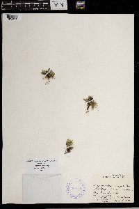 Selaginella rupestris (L.) Spring 388211[1372363] United States, New Jersey |
MIN:Plants | 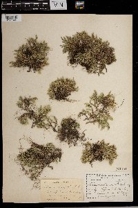 Selaginella rupestris (L.) Spring 261194[1372364] United States, Illinois |
Google Map
Google Maps is a web mapping service provided by Google that features a map that users can pan (by dragging the mouse) and zoom (by using the mouse wheel). Collection points are displayed as colored markers that when clicked on, displays the full information for that collection. When multiple species are queried (separated by semi-colons), different colored markers denote each individual species.