University of Minnesota
http://www.umn.edu/
612-625-5000
http://www.umn.edu/
612-625-5000
Minnesota Biodiversity Atlas
Bell Museum
Dataset: MIN-Plants
Taxa: Selaginellaceae
Search Criteria: excluding cultivated/captive occurrences
Bell Museum plants | |
 MIN:Plants | 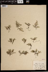 Selaginella rupestris (L.) Spring 261185[1372365] United States, Oregon |
MIN:Plants | 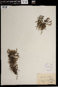 Selaginella rupestris (L.) Spring 346577[1372366] United States, North Carolina |
MIN:Plants | 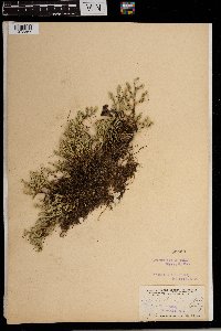 Selaginella rupestris (L.) Spring 55560[1372367] United States, Tennessee |
MIN:Plants | 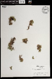 Selaginella rupestris (L.) Spring 722787[1372368] United States, North Dakota |
MIN:Plants | 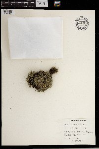 Selaginella rupestris (L.) Spring 738855[1372369] Canada, Ontario |
MIN:Plants | 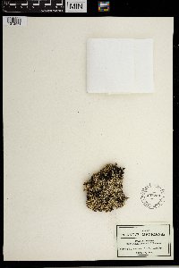 Selaginella rupestris (L.) Spring 558769[1372561] Mexico |
MIN:Plants |  Selaginella rupestris (L.) Spring 970989[1394457]Smith, Welby R WRS359502018-06-18 United States, Minnesota, Morrison, On the airfield at the Camp Ripley Military Reservation. About 12.5 km (7.8 miles) due north of the approximate center of Little Falls., 46.0937833 -94.3632667 |
MIN:Plants | 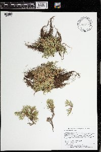 Selaginella rupestris (L.) Spring 973470[1397024]Lee, Michael MDL56422011-07-26 United States, Minnesota, Lake, Boundary Waters Canoe Area Wilderness; Rolling bedrock terrain north of the Fernberg Road, 13 miles east-northeast of Ely. Local on tiny bedrock islet in Wood Lake., 47.98370139 -91.58976261, 410m |
MIN:Plants | 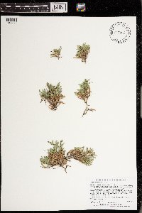 Selaginella rupestris (L.) Spring 973325[1398878]Lee, Michael MDL57062011-08-18 United States, Minnesota, Lake, Hubachek Wilderness Research Station; Rugged bedrock terrain north of Fall Lake, on the edge of the Boundary Waters Canoe Area Wilderness, six miles northeast of Ely, at the scenic Browns Lake overlook., 47.95958836 -91.75476904, 439m |
MIN:Plants | 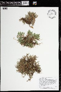 Selaginella rupestris (L.) Spring 973472[1397026]Lee, Michael MDL55232011-06-03 United States, Minnesota, Stearns, Quarry Park Scientific & Natural Area; Gently rolling terrain on the south side of Waite Park., 45.52815041 -94.23767955, 341m |
MIN:Plants | 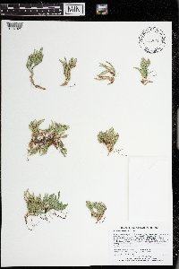 Selaginella rupestris (L.) Spring 973471[1397025]Lee, Michael MDL55892011-06-15 United States, Minnesota, Lake, Along the Snowbank Hiking Trail in strongly rolling bedrock terrain on the west side of Snowbank Lake, 18 miles east-northeast of Ely., 47.98348084 -91.46789254, 460m |
MIN:Plants | 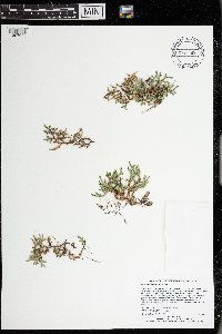 Selaginella rupestris (L.) Spring 973469[1397023]Lee, Michael MDL56272011-06-28 United States, Minnesota, Lake, Rugged bedrock terrain south of the Fernberg Road, 12 miles east-northeast of Ely, along a two-track forest road leading to Madden Lake., 47.95400302 -91.59878165, 457m |
MIN:Plants | 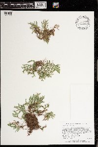 Selaginella rupestris (L.) Spring 973322[1398875]Lee, Michael MDL56812011-08-10 United States, Minnesota, Lake, Rugged bedrock terrain in the White Hills, seven miles north-northeast of Ely. Local on the eastern shore of Hawks Nest Lake., 47.99153727 -91.79002981, 425m |
MIN:Plants | 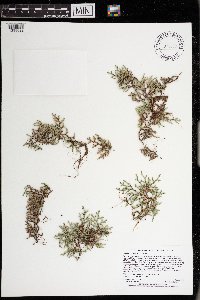 Selaginella rupestris (L.) Spring 973069[1398622]Lee, Michael MDL60642012-08-05 United States, Minnesota, Lake, Boundary Waters Canoe Area Wilderness; Rugged bedrock terrain on the south side of Newfound Lake, 20 miles east-northeast of Ely., 48.0193127366 -91.4553698795, 451m |
MIN:Plants | 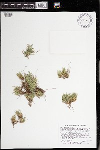 Selaginella rupestris (L.) Spring 973068[1398621]Lee, Michael MDL60702012-08-06 United States, Minnesota, Lake, Boundary Waters Canoe Area Wilderness; Fairly rugged bedrock terrain between Newfound and Manomin Lakes, 20 miles east-northeast of Ely; west of Juggler Lake., 48.0381618047 -91.4579994278, 436m |
MIN:Plants | 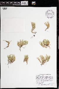 Selaginella rupestris (L.) Spring 973057[1398610]Lee, Michael MDL61172012-08-18 United States, Minnesota, Lake, Boundary Waters Canoe Area Wilderness; On the shores of Basswood Lake in rugged bedrock terrain 14 miles north-northeast of Ely; in the northeastern end of Jackfish Bay., 48.0745305611 -91.6759218452, 415m |
MIN:Plants | 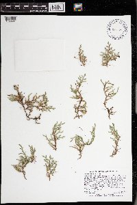 Selaginella rupestris (L.) Spring 973054[1398607]Lee, Michael MDL61212012-08-19 United States, Minnesota, Lake, Boundary Waters Canoe Area Wilderness; On the shores of Basswood Lake in fairly rugged bedrock terrain 12 miles northeast of Ely. Local near campsite #30 on the north shore of Pipestone Bay, one mile southwest of Lewis Narrows., 48.0464339484 -91.681580105, 399m |
MIN:Plants | 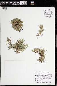 Selaginella rupestris (L.) Spring 973063[1398616]Lee, Michael MDL59292012-06-21 United States, Minnesota, Lake, Rugged bedrock terrain north of the Fernberg Road, east of the Moose Lake Road, 16 miles east-northeast of Ely., 47.9738491148 -91.5064515474, 448m |
MIN:Plants | 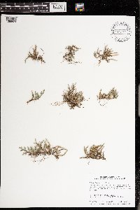 Selaginella rupestris (L.) Spring 974267[1396631]Smith, Welby R WRS366002019-10-25 United States, Minnesota, Sherburne, Oak Savanna County Park, just north (<1 km) of Becker., 45.41639 -93.88745 |
MIN:Plants | 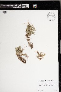 Selaginella rupestris (L.) Spring 975824[1404817]Dunevitz, Hannah L. 5521991-07-30 United States, Minnesota, Winona, About 1/2 mile north of the Fillmore County line, and .4 miles east of County Road 25,, 43.86 -91.77 |
MIN:Plants | 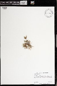 Selaginella rupestris (L.) Spring 975844[1404896]Dunevitz, Hannah L. 11351994-09-27 United States, Minnesota, Wabasha, of Zumbro Bottoms State Forest. On a southwest-facing slope in the Sand Coulee area, 44.32 -92.11 |
MIN:Plants | 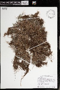 Selaginella rupestris (L.) Spring 975915[1373468]Smith, Welby R WRS366272020-04-19 United States, Minnesota, Dakota, Sand Coulee State Scientific and Natural Area; about 6.7 km (4.2 miles) S-SE of the Mississippi River Bridge in Hastings., 44.69099 -92.82091 |
MIN:Plants | 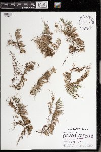 Selaginella rupestris (L.) Spring 975933[1373486]Smith, Welby R WRS366282020-04-19 United States, Minnesota, Dakota, Sand Coulee State Scientific and Natural Area; about 6.7 km (4.2 miles) S-SE of the Mississippi River Bridge in Hastings., 44.69099 -92.82091 |
MIN:Plants | 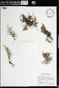 Selaginella rupestris (L.) Spring 976283[1373836]Smith, Welby R WRS369552020-08-29 United States, Minnesota, Dakota, Sand Coulee State Scientific and Natural Area; about 6.7 km (4.2 miles) S-SE of the Mississippi River Bridge in Hastings., 44.69099 -92.82091 |
MIN:Plants | 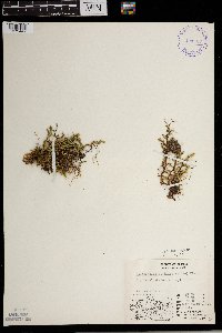 Selaginella sibirica (J. Milde) Hieronymus 401737[1372447]Spetzman, L. 9221948-07-30 United States, Alaska, Arctic North Slope ... Ikiakpauruk Valley,;Arctic National Wildlife Refuge;;;, 69.5 -145.5, 914m |
MIN:Plants | 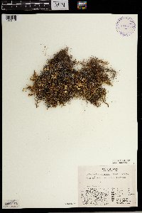 Selaginella sibirica (J. Milde) Hieronymus 401735[1372448]Spetzman, L. 14041948-07-11 United States, Alaska, Arctic North Slope ... Lake Peters;Arctic National Wildlife Refuge;;;, 69.3333333 -145, 1219m |
MIN:Plants | 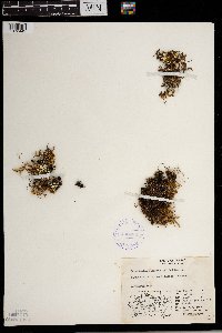 Selaginella sibirica (J. Milde) Hieronymus 408489[1372449]Spetzman, L. 16131949-07-02 United States, Alaska, Arctic North Slope ... Anaktuvuk Pass;Gates of the Arctic National Park;;;, 68.2833333 -151.4166667, 610m |
MIN:Plants | 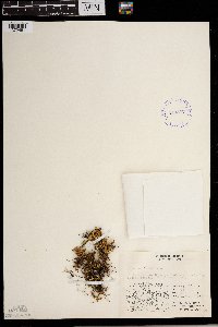 Selaginella sibirica (J. Milde) Hieronymus 413897[1372451]Spetzman, L. 17411949-07-07 United States, Alaska, Arctic North Slope ... Anaktuvuk Pass;Gates of the Arctic National Park;;;, 68.2833333 -151.4166667, 1524m |
MIN:Plants | 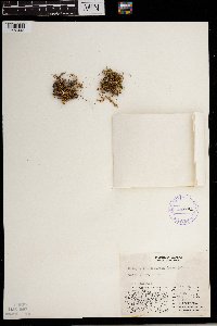 Selaginella sibirica (J. Milde) Hieronymus 408491[1372445]Spetzman, L. s.n.1948-07-18 United States, Alaska, Arctic North Slope ... Lake Schrader;Arctic National Wildlife Refuge;;;, 69.4166667 -145, 914m |
MIN:Plants | 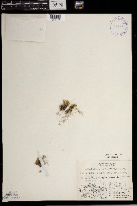 Selaginella sibirica (J. Milde) Hieronymus 401736[1372446]Spetzman, L. 11151948-08-12 United States, Alaska, Arctic North Slope ...Sunset Pass...Sadlerochit R.;Arctic National Wildlife Refuge;;;, 69.5833359 -144.6666718, 1219m |
MIN:Plants |  Selaginella sibirica (J. Milde) Hieronymus 408487[1372450]Spetzman, L. 16401949-07-05 United States, Alaska, Arctic North Slope ... Anaktuvuk Pass.;Gates of the Arctic National Park;;;, 68.2833333 -151.4166667, 762m |
MIN:Plants |  Selaginella sibirica (J. Milde) Hieronymus 954978[1295283]Miller, Maynard M. 1141948-00-00 United States, Alaska, St. Elias Mountains. Mt. Vancouver, site 1 |
MIN:Plants |  Selaginella sibirica (J. Milde) Hieronymus 954892[1295369]Baird, Patrick 2571948-00-00 United States, Alaska, St. Elias Mountains. Mt. Vancouver, base camp |
MIN:Plants | 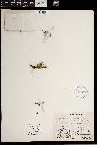 Selaginella sibirica (J. Milde) Hieronymus 408490[1372452] United States, Alaska |
MIN:Plants | 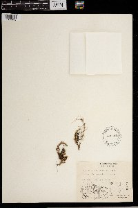 Selaginella sibirica (J. Milde) Hieronymus 548460[1372453] United States, Alaska |
MIN:Plants | 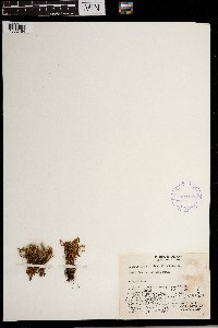 Selaginella sibirica (J. Milde) Hieronymus 408488[1372454] United States, Alaska |
MIN:Plants | 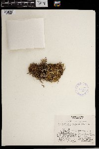 Selaginella sibirica (J. Milde) Hieronymus 416048[1372455] United States, Alaska |
MIN:Plants | 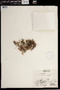 Selaginella sibirica (J. Milde) Hieronymus 416057[1372456] United States, Alaska |
MIN:Plants | 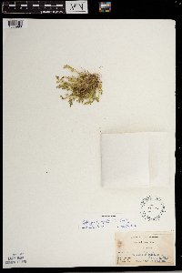 Selaginella apoda (L.) Spring 55485[1383996]Beardslee, H.; et al. s.n.1891-08-08 United States, North Carolina, Swain, Great Smoky Mountains ... Swain County;Great Smoky Mountains National Park, 518m |
MIN:Plants | 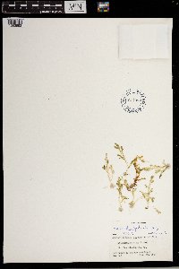 Selaginella apoda (L.) Spring 617992[1383993] United States, Iowa |
MIN:Plants | 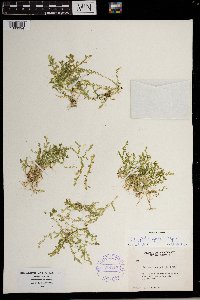 Selaginella apoda (L.) Spring 388217[1383994] United States, Kentucky |
MIN:Plants | 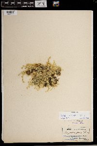 Selaginella apoda (L.) Spring 55487[1383995] United States, Pennsylvania |
MIN:Plants | 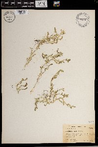 Selaginella apoda (L.) Spring 482512[1383997] United States, Florida |
MIN:Plants | 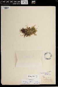 Selaginella apoda (L.) Spring 55480[1383998] United States, Florida |
MIN:Plants | 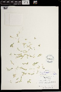 Selaginella apoda (L.) Spring 623008[1383999] United States, North Carolina |
MIN:Plants | 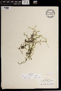 Selaginella apoda (L.) Spring 969649[1384000] United States, Florida |
MIN:Plants | 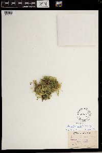 Selaginella apoda (L.) Spring 55478[1372165] United States, New Hampshire |
MIN:Plants | 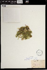 Selaginella apoda (L.) Spring 55477[1372166] United States |
MIN:Plants | 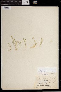 Selaginella apoda (L.) Spring 55486[1372167] United States, Pennsylvania |
MIN:Plants | 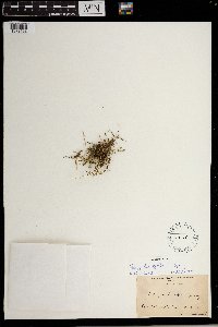 Selaginella apoda (L.) Spring 281144[1372168] United States, Georgia |
MIN:Plants |  Selaginella apoda (L.) Spring 452495[1372169] United States, Rhode Island |
MIN:Plants | 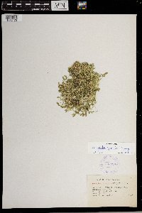 Selaginella apoda (L.) Spring 333929[1372170] United States, West Virginia |
MIN:Plants | 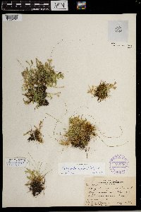 Selaginella apoda (L.) Spring 352965[1372171] United States, Massachusetts |
MIN:Plants | 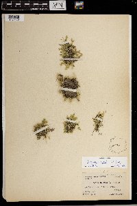 Selaginella apoda (L.) Spring 55476[1372172] United States, New York |
MIN:Plants | 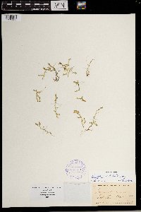 Selaginella apoda (L.) Spring 388220[1372173] United States, New York |
MIN:Plants | 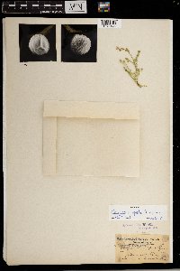 Selaginella apoda (L.) Spring 55484[1372174] United States, Pennsylvania |
MIN:Plants | 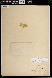 Selaginella apoda (L.) Spring 55483[1372175] United States, Massachusetts |
MIN:Plants | 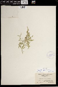 Selaginella apoda (L.) Spring 415119[1372176] United States, Maryland |
MIN:Plants | 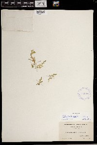 Selaginella apoda (L.) Spring 415118[1372177] United States, Florida |
MIN:Plants | 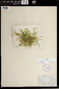 Selaginella apoda (L.) Spring 355302[1372178] United States, South Carolina |
MIN:Plants | 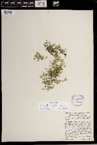 Selaginella apoda (L.) Spring 349218[1372179] United States, West Virginia |
MIN:Plants | 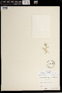 Selaginella apoda (L.) Spring 544855[1372180] United States, Indiana |
MIN:Plants |  Selaginella apoda (L.) Spring 375313[1372181] United States, Kentucky |
MIN:Plants |  Selaginella apoda (L.) Spring 558887[1372528] Mexico |
MIN:Plants | Selaginella selaginoides (L.) Palisot de Beauvois ex Martius & Schrank 55590[1372412]Connor, L. United States, Michigan, Keweenaw, Detailed locality information protected. This is typically done to protect rare or threatened species localities. |
MIN:Plants | Selaginella selaginoides (L.) Palisot de Beauvois ex Martius & Schrank 433048[1311476]Smith, Welby; et al. United States, Minnesota, Cook, Detailed locality information protected. This is typically done to protect rare or threatened species localities. |
MIN:Plants | Selaginella selaginoides (L.) Palisot de Beauvois ex Martius & Schrank 55592[1372404]Wheeler, William United States, Michigan, Keweenaw, Detailed locality information protected. This is typically done to protect rare or threatened species localities. |
MIN:Plants | Selaginella selaginoides (L.) Palisot de Beauvois ex Martius & Schrank 387799[1383978]Abbe, E.; Abbe, L. United States, Minnesota, Cook, Detailed locality information protected. This is typically done to protect rare or threatened species localities. |
MIN:Plants | Selaginella selaginoides (L.) Palisot de Beauvois ex Martius & Schrank 387800[1383977]Schuster, R. United States, Minnesota, Cook, Detailed locality information protected. This is typically done to protect rare or threatened species localities. |
MIN:Plants | Selaginella selaginoides (L.) Palisot de Beauvois ex Martius & Schrank 387801[1383976]Schuster, R. United States, Minnesota, Cook, Detailed locality information protected. This is typically done to protect rare or threatened species localities. |
MIN:Plants | Selaginella selaginoides (L.) Palisot de Beauvois ex Martius & Schrank 393242[1311477]Ownbey, Gerald; et al. United States, Minnesota, Cook, Detailed locality information protected. This is typically done to protect rare or threatened species localities. |
MIN:Plants | Selaginella selaginoides (L.) Palisot de Beauvois ex Martius & Schrank 393266[1311478]Ownbey, Gerald; et al. United States, Minnesota, Cook, Detailed locality information protected. This is typically done to protect rare or threatened species localities. |
MIN:Plants | Selaginella selaginoides (L.) Palisot de Beauvois ex Martius & Schrank 55599[1383979]Cheney, L. United States, Minnesota, Cook, Detailed locality information protected. This is typically done to protect rare or threatened species localities. |
MIN:Plants | Selaginella selaginoides (L.) Palisot de Beauvois ex Martius & Schrank 220341[1372411]Cooper, William United States, Michigan, Keweenaw, Detailed locality information protected. This is typically done to protect rare or threatened species localities. |
MIN:Plants | Selaginella selaginoides (L.) Palisot de Beauvois ex Martius & Schrank 55593[1372406]Sandberg, John United States, Michigan, Keweenaw, Detailed locality information protected. This is typically done to protect rare or threatened species localities. |
MIN:Plants | Selaginella selaginoides (L.) Palisot de Beauvois ex Martius & Schrank 962758[1346383]Gockman, Otto United States, Minnesota, Lake, Detailed locality information protected. This is typically done to protect rare or threatened species localities. |
MIN:Plants | Selaginella selaginoides (L.) Palisot de Beauvois ex Martius & Schrank 556355[1372400] Canada, Ontario, Detailed locality information protected. This is typically done to protect rare or threatened species localities. |
MIN:Plants | Selaginella selaginoides (L.) Palisot de Beauvois ex Martius & Schrank 521083[1372402] Canada, Manitoba, Detailed locality information protected. This is typically done to protect rare or threatened species localities. |
MIN:Plants | Selaginella selaginoides (L.) Palisot de Beauvois ex Martius & Schrank 566134[1372403] Canada, Manitoba, Detailed locality information protected. This is typically done to protect rare or threatened species localities. |
MIN:Plants | Selaginella selaginoides (L.) Palisot de Beauvois ex Martius & Schrank 388209[1372405] United States, Michigan, Detailed locality information protected. This is typically done to protect rare or threatened species localities. |
MIN:Plants | Selaginella selaginoides (L.) Palisot de Beauvois ex Martius & Schrank 86878[1372407] Canada, British Columbia, Detailed locality information protected. This is typically done to protect rare or threatened species localities. |
MIN:Plants | Selaginella selaginoides (L.) Palisot de Beauvois ex Martius & Schrank 556286[1372408] Canada, Ontario, Detailed locality information protected. This is typically done to protect rare or threatened species localities. |
MIN:Plants | Selaginella selaginoides (L.) Palisot de Beauvois ex Martius & Schrank 555548[1372409] Canada, Ontario, Detailed locality information protected. This is typically done to protect rare or threatened species localities. |
MIN:Plants | Selaginella selaginoides (L.) Palisot de Beauvois ex Martius & Schrank 556031[1372410] Canada, Ontario, Detailed locality information protected. This is typically done to protect rare or threatened species localities. |
MIN:Plants | Selaginella selaginoides (L.) Palisot de Beauvois ex Martius & Schrank 566157[1372413] Canada, Manitoba, Detailed locality information protected. This is typically done to protect rare or threatened species localities. |
MIN:Plants | Selaginella selaginoides (L.) Palisot de Beauvois ex Martius & Schrank 555546[1372414] Canada, Ontario, Detailed locality information protected. This is typically done to protect rare or threatened species localities. |
MIN:Plants | Selaginella selaginoides (L.) Palisot de Beauvois ex Martius & Schrank 556337[1372415] Canada, Ontario, Detailed locality information protected. This is typically done to protect rare or threatened species localities. |
MIN:Plants | Selaginella selaginoides (L.) Palisot de Beauvois ex Martius & Schrank 556341[1372416] Canada, Ontario, Detailed locality information protected. This is typically done to protect rare or threatened species localities. |
MIN:Plants | Selaginella selaginoides (L.) Palisot de Beauvois ex Martius & Schrank 473181[1372417] Canada, Quebec, Detailed locality information protected. This is typically done to protect rare or threatened species localities. |
MIN:Plants | Selaginella selaginoides (L.) Palisot de Beauvois ex Martius & Schrank 473183[1372418] Canada, Quebec, Detailed locality information protected. This is typically done to protect rare or threatened species localities. |
MIN:Plants | Selaginella selaginoides (L.) Palisot de Beauvois ex Martius & Schrank 473182[1372419] Canada, Quebec, Detailed locality information protected. This is typically done to protect rare or threatened species localities. |
MIN:Plants | Selaginella selaginoides (L.) Palisot de Beauvois ex Martius & Schrank 55589[1372420] Canada, Quebec, Detailed locality information protected. This is typically done to protect rare or threatened species localities. |
MIN:Plants | Selaginella selaginoides (L.) Palisot de Beauvois ex Martius & Schrank 599623[1372421] United States, Alaska, Detailed locality information protected. This is typically done to protect rare or threatened species localities. |
MIN:Plants | Selaginella selaginoides (L.) Palisot de Beauvois ex Martius & Schrank 541144[1372422] Canada, British Columbia, Detailed locality information protected. This is typically done to protect rare or threatened species localities. |
MIN:Plants | Selaginella selaginoides (L.) Palisot de Beauvois ex Martius & Schrank 55594[1372423] United States, Alaska, Detailed locality information protected. This is typically done to protect rare or threatened species localities. |
MIN:Plants | Selaginella selaginoides (L.) Palisot de Beauvois ex Martius & Schrank 261188[1372424] Canada, Newfoundland, Detailed locality information protected. This is typically done to protect rare or threatened species localities. |
MIN:Plants | Selaginella selaginoides (L.) Palisot de Beauvois ex Martius & Schrank 530004[1372425] Canada, Quebec, Detailed locality information protected. This is typically done to protect rare or threatened species localities. |
MIN:Plants | Selaginella selaginoides (L.) Palisot de Beauvois ex Martius & Schrank 479466[1372426] Canada, Quebec, Detailed locality information protected. This is typically done to protect rare or threatened species localities. |
MIN:Plants | Selaginella selaginoides (L.) Palisot de Beauvois ex Martius & Schrank 533595[1372427] Canada, Quebec, Detailed locality information protected. This is typically done to protect rare or threatened species localities. |
MIN:Plants | Selaginella selaginoides (L.) Palisot de Beauvois ex Martius & Schrank 473179[1372428] Canada, Quebec, Detailed locality information protected. This is typically done to protect rare or threatened species localities. |
Google Map
Google Maps is a web mapping service provided by Google that features a map that users can pan (by dragging the mouse) and zoom (by using the mouse wheel). Collection points are displayed as colored markers that when clicked on, displays the full information for that collection. When multiple species are queried (separated by semi-colons), different colored markers denote each individual species.