University of Minnesota
http://www.umn.edu/
612-625-5000
http://www.umn.edu/
612-625-5000
Minnesota Biodiversity Atlas
Bell Museum
Dataset: MIN-Plants
Taxa: Lonicera
Search Criteria: excluding cultivated/captive occurrences
Bell Museum plants | |
 MIN:Plants | 505320[]Smith, Welby 270861998-05-15 United States, Minnesota, Sibley, Sibley County ... Rush River State Wayside (Minnesota Valley Recreation Area), about 2 miles southwest of Henderson ... T 112N R 26W SW1/4 of SE1/4 of Sec 15. 112N 26W 15, 44.5008333 -93.9380556 |
MIN:Plants | Lonicera caerulea var. villosa (Michaux) Torrey & A. Gray 896943[]Lake, Roger 01-52001-05-20 United States, Minnesota, Saint Louis, St. Louis County...T 59N R 21W NW1/4 of NE1/4 of Sec 1;Superior National Forest;059N;21W;01, 47.6246 -92.943311 |
MIN:Plants | Lonicera morrowii A. Gray 491596[]Smith, Welby 278541999-06-03 United States, Minnesota, Goodhue, Goodhue County ... On the Mississippi River bottoms, about 2 mi west of Red Wing ... T113N R15W SW1/4 of NE1/4 of Sec 22;Dorer Memorial Hardwood State Forest;113N;15W;22, 44.5791667 -92.5977778 |
MIN:Plants | Lonicera hirsuta Eaton 910985[]Smith, Welby 244971994-06-27 United States, Minnesota, Hubbard, Crow Wing Chain Wildlife Management Area. Hubbard County...Crow Wing Chain State Wildlife Management Area; about 11 miles southeast of Park Rapids...T 139N R 33W NE1/4 of SE1/4 of Sec 15. 139N 33W 15, 46.8536111 -94.8366667 |
MIN:Plants | 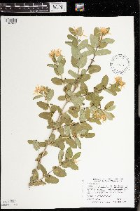 462046[1397630]Smith, Welby 271461998-05-26 United States, Minnesota, Pine, Banning State Park. Pine County ... Banning State Park, about 2.5 miles north-northeast of Sandstone ... along the Kettle River ... T 43N R 20W SW1/4 of NE1/4 of Sec 35. 043N 20W 35, 46.1658333 -92.8327778 |
MIN:Plants | 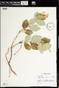 Lonicera hirsuta Eaton 490565[1397587]Gerdes, Lynden 47402003-07-07 United States, Minnesota, Lake, Superior National Forest. T59N R07W S02NWNE Lake County ... Superior National Forest. Approximately 8.41 miles ENE of Isabella, MN and 0.75 mile SE of Scott Lake.. 059N 07W 2, 47.624337 -91.181725 |
MIN:Plants | 913023[]Smith, Welby 241061994-05-17 United States, Minnesota, Le Sueur, Chamberlain Woods Scientific Natural Area. Le Sueur County...In Chamberlain Woods State Scientific and Natural Area; about one mile north of Ottawa...T 111N R26W SW1/4of SW1/4 of Sec 22. 111N 26W 22, 44.4008333 -93.9472222 |
MIN:Plants | Lonicera canadensis W. Bartram ex Marshall 908508[]Lee, Michael MDL42172006-06-07 United States, Minnesota, Wadena, Wadena County ... Headwaters of Little Swamp Creek, 5.5 miles northeast of Nimrod ... T137N R33W NE1/4 of SE1/4 Sec. 12 ... UTM: 51724745N 363203E. 137N 33W 12, 46.695097 -94.797092 |
MIN:Plants | 904208[]Smith, Welby 279721999-07-09 United States, Minnesota, Kandiyohi, Sibley State Park. Kandiyohi County...Sibley State Park, about 12 miles north of Wilmar...north shore of Andrew Lake...T 121N R 35W NE1/4 of NE1/4 of Sec 2. 121N 35W 2, 45.3233333 -95.0305556 |
MIN:Plants | 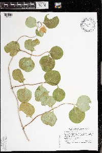 Lonicera prolifera (von Kirchner) Booth ex Rehder 438474[1397620]Smith, Welby 25943A1995-09-06 United States, Minnesota, Mower, Mower County...In Lake Louise State Park, about 1.5 miles north-northwest of LeRoy...T101N R14W SE1/4 of SW1/4 of Sec 21;Lake Louise State Park;101N;14W;21, 43.536579 -92.519043 |
MIN:Plants | Lonicera x bella Zabel 904504[]Smith, Welby 274331998-07-23 United States, Minnesota, Renville, Skalbakken County Park. Renville County ... Skalbakken County Park, about 4.5 miles Southwest of Sacred Heart ... T115N R38W SW1/4 of SE1/4 of Sec 27. 115N 38W 27, 44.7338889 -95.4097222 |
MIN:Plants | 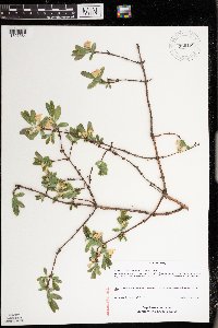 Lonicera caerulea var. edulis Turczaninow ex Herder 920189[1397564]Schimpf, D. DJS5852010-04-28 United States, Minnesota, Saint Louis, St. Louis County, Duluth. T50N R14W SW1/4 Sec 8;;050N;14W;08, 46.8277778 -92.15 |
MIN:Plants |  Lonicera morrowii A. Gray 492549[1397597]Smith, Welby 271471998-05-26 United States, Minnesota, Pine, Banning State Park. Pine County ... Banning State Park, about 2.5 miles north-northeast of Sandstone ... along the Kettle River ... T 43N R 20W SW1/4 of NE1/4 of Sec 35. 043N 20W 35, 46.1658333 -92.8327778 |
MIN:Plants | Lonicera oblongifolia (Goldie) Hooker 897546[]Lake, Roger 01-182001-07-27 United States, Minnesota, Itasca, Itasca County...T 53N R 22W NW1/4 of NE!14 of Sec 6;;053N;22W;06, 47.103568 -93.176069 |
MIN:Plants | Lonicera x bella Zabel 917006[]Smith, Welby 224001993-06-11 United States, Minnesota, Winona, Whitewater Wildlife Management Area. Winona County...Whitewater State Wildlife Management Area, about 6 miles south-southwest of Weaver...T108N R10W NW1/4 of SE1/4 of Sec 23. 108N 10W 23, 44.1394444 -91.9861111 |
MIN:Plants |  Lonicera x bella Zabel 454910[1397561]Gerdes, Lynden 39732000-06-13 United States, Minnesota, Lake, Lake County ... Tettegouche State Park ... North of Silver Bay, MN. Lax Lake overlook area ... T56N R07W S07NWSW;North Shore / Tettegouche State Park;056N;07W;07, 47.350541 -91.272185 |
MIN:Plants |  510598[1397629]Wheeler, Gerald 193791998-06-23 United States, Minnesota, Carver, Carver County ... Ca. 4 mi. SSW of East Union; between Kelly Lake and Hallquist Lake ... SW1/4 NE1/4 Sec. 21 T114N R24W;;114N;24W;21, 44.663581 -93.712406 |
MIN:Plants | Lonicera x bella Zabel 904495[]Smith, Welby 272561998-06-16 United States, Minnesota, Saint Louis, St. Louis County ... Kitchi Gammi Park in Duluth; between North Shore Drive and Lake Superior ... T51N R13W NW1/4 of SE1/4 of Sec 34. 051N 13W 34, 46.8575 -91.9722222 |
MIN:Plants | 463551[]Smith, Welby 272151998-06-06 United States, Minnesota, Anoka, Lamprey Pass Wildlife Management Area. Anoka County...Lamprey Pass State Wildlife Management Area, about 2 miles southwest of Forest Lake (town)...T 32N R 22W SW1/4 of NE1/4 of Sec 13. 032N 22W 13, 45.2619444 -93.0294444 |
MIN:Plants | Lonicera x bella Zabel 479215[]Kaul, R. 71071992-05-20 United States, Minnesota, Steele, Steele County...along Lemond Road by Straight River, Owatonna.;;107N;20W;00, 44.066112 -93.226071 |
MIN:Plants | Lonicera caerulea var. villosa (Michaux) Torrey & A. Gray 908517[]Lee, Michael MDL42162006-06-07 United States, Minnesota, Wadena, Wadena County ... Headwaters of Little Swamp Creek, 5.5 miles northeast of Nimrod ... T137N R33W NE1/4 of SE1/4 Sec. 12 ... UTM: 51724745N 363203E. 137N 33W 12, 46.695097 -94.797092 |
MIN:Plants |  Lonicera x bella Zabel 429332[1397557]Smith, Welby 272801998-06-25 United States, Minnesota, Anoka, Anoka County ... Rum River North County Park, about 7 miles NW of East Bethel ... T 134N R 24W NW1/4 of NE1/4 of Sec 32;Rum River County Park;134N;24W;32, 45.3902778 -93.355 |
MIN:Plants | 909221[]Smith, Welby 218521992-09-03 United States, Minnesota, Watonwan, Watonwan County...At the public access on the north side of Fedji Lake, about 2 miles northeast of Madelia...T 107N R 30W SW1/4 of SW1/4 of Sec 12. 107N 30W 12, 44.0816667 -94.3880556 |
MIN:Plants | Lonicera flava Sims 608156[]Mullens, N.; et al. 680271968-04-23 United States, South Carolina, Greenville, Greenville County ... on Little Texas Road. Burns farm. Just north of Paris Mt. |
MIN:Plants | Lonicera dioica var. glaucescens (Rydberg) Butters 916854[]Smith, Welby 224231993-06-18 United States, Minnesota, Grant, Grant County ... On the south side of Ask Lake, about 1.5 miles east-southeast of Ashby ...T130N R41W NW1/4 of SW1/4 of Sec 12. 130N 41W 12, 46.0847222 -95.7886111 |
MIN:Plants | Lonicera x bella Zabel 493601[]Smith, Welby 165291990-05-14 United States, Minnesota, Steele, Rice Lake State Park. Steele County ... Rice Lake State Park, about 7 miles east of Owatonna; on the north side of Rice Lake ...T107N R19W NW1/4 of SW1/4 of Sec 12. 107N 19W 12, 44.0855556 -93.0655556 |
MIN:Plants | Lonicera dioica var. glaucescens (Rydberg) Butters 295416[]Benner, F.; Benner, J. 2161928-06-01 United States, Wisconsin, Polk, 6-1/2 mi N. of St. Croix - E. of River Road;Saint Croix National Riverway;;;, 45.493323 -92.696179 |
MIN:Plants | Lonicera caerulea var. villosa (Michaux) Torrey & A. Gray 897490[]Smith, Welby 292382001-07-27 United States, Minnesota, Cook, Cook County...On the east side of Plouff Creek, in the Superior Natioanl Forest...T61N R15W NW1/4 of NW1/4 of sec 2;Superior National Forest;061N;15W;02, 47.7980556 -90.9305556 |
MIN:Plants | Lonicera x bella Zabel 438665[]Smith, Welby 166831990-05-24 United States, Minnesota, Olmsted, Olmsted County...In Oxbow County Park, about 3 miles north of Byron...T107N R15W NW!/4 of SW1/4 of Sec 8;Oxbow County Park;107N;15W;08, 44.0861111 -92.6544444 |
MIN:Plants | Lonicera x bella Zabel 456130[]Smith, Welby 256821995-06-20 United States, Minnesota, Lake, Lake County ... About 1 mile south of Silver Bay (town) ... shore of Lake Superior ... T55N R7W SE1/4 of SW1/4 of Sec 6;North Shore;055N;07W;06, 47.2744444 -91.2738889 |
MIN:Plants | Lonicera morrowii A. Gray 510580[]Wheeler, Gerald 192701998-06-17 United States, Minnesota, Scott, Scott County ... Ca. 1 mi. NW of Jordan ... W1/2 SE1/4 Sec. 12 T114N R24W (St. Lawrence 12);;114N;24W;12, 44.691524 -93.654586 |
MIN:Plants | 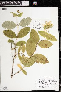 Lonicera hirsuta Eaton 428913[1397594]Smith, Welby 279501999-06-29 United States, Minnesota, Carlton, Carlton County ... At the rest stop on N-bound I-35, about 10 miles north of Moose Lake (town)... T 47N R 18W NE1/4 of NE1/4 of Sec 22. 047N 18W 22, 46.5455556 -92.6138889 |
MIN:Plants | Lonicera flava Sims 379926[]Demaree, Delzie 228571942-05-09 United States, Arkansas, Logan, Magazine Mountain. Ozark National Forest. Logan County ... P.O. Magazine Mountain, 853m |
MIN:Plants | 453711[]U.S. Fish & Wildlife personnel 9181994-08-01 United States, Minnesota, Sherburne, Sherburne National Wildlife Refuge ... NENE 15-35-27;Sherburne National Wildlife Refuge;035N;27W;15, 45.523144 -93.685378 |
MIN:Plants | Lonicera dioica var. glaucescens (Rydberg) Butters 352276[]Nielsen, E. 261927-07-25 United States, Wisconsin, Polk, Across from Taylors Falls, on Wisconsin side of river.;Saint Croix National Riverway;;;, 45.4 -92.65 |
MIN:Plants | Lonicera caerulea var. villosa (Michaux) Torrey & A. Gray 456127[]Smith, Welby 246171994-07-11 United States, Minnesota, Koochiching, Koochiching County ... About three miles east of Northome. Along margin of Tuefer Lake ... T 151N R 28W SW1/4 of NE1/4 of Sec 27. 151N 28W 27, 47.867615 -94.219893 |
MIN:Plants | Lonicera morrowii A. Gray 904812[]Smith, Welby 277581999-05-19 United States, Minnesota, Winona, Winona County...About 1/2 mile east of Elba...T 107N R 10W NE1/4 of NW1/4 of Sec 10;;T107N R10W S10, 44.085596 -92.009536 |
MIN:Plants | Lonicera x bella Zabel 510304[]Lee, Michael MDL23371998-07-31 United States, Minnesota, Morrison, Belle Prairie County Park. Morrison County ... Belle Prairie County Park along the Mississippi River 1/2 mile north of Bell Prairie ... T41N R32W NW1/4 of NE1/4 Sec. 14. 041N 32W 14, 46.034664 -94.340306 |
MIN:Plants | Lonicera involucrata (Richardson) Banks ex C.P.J. Sprengel 510348[]US Nat. Arboretum staff 1978-491978-00-00 Canada, British Columbia, [no further data] |
MIN:Plants | Lonicera canadensis W. Bartram ex Marshall 462021[]Smith, Welby 241521994-05-30 United States, Minnesota, Itasca, Itasca County ... In Scenic State Park; about 9 miles south-southeast of Effie ... T 60N R 26W NE1/4 of NE1/4 of Sec 1;Scenic State Park;060N;26W;01, 47.7186111 -93.5808333 |
MIN:Plants | 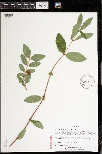 Lonicera caerulea var. edulis Turczaninow ex Herder 914213[1397566]Pomroy, Deborah; et al. DLP2666c2009-06-24 United States, Minnesota, Saint Louis, St. Louis County, Duluth. T50N R14W NE1/4 of NW1/4 of SW1/4 Sec 8. 15T: 0564814E, 5186380N;;050N;14W;08, 46.8277778 -92.1502778 |
MIN:Plants | 913707[]Smith, Welby 231751993-07-29 United States, Minnesota, Grant, Grant County... On the south side of Ask Lake, about 1.5 miles E-SE of Ashby... T130N R41W NW1/4 of SW1/4 of Sec 12;;130N;41W;12, 46.0847222 -95.7886111 |
MIN:Plants | Lonicera x bella Zabel 438656[]Smith, Welby 166121990-05-17 United States, Minnesota, Steele, Steele County...Wayside rest at I35 crossing of Straight River...T106N R20W NE1/4 of etc.;;106N;20W;17, 43.9852778 -93.2575 |
MIN:Plants | Lonicera x bella Zabel 431970[]Barberg, T. 22102006-10-04 United States, Minnesota, Ramsey, Ramsey Co, Lauderdale Nature Preserve, approx. 1/8 mile south of Larpenteur Ave, between highway 280 and Cleveland Ave;;029N;23W;20, 44.98449 -93.197494 |
MIN:Plants | 453710[]Moore, John 3941971-07-29 United States, Minnesota, Sherburne, S.E. 1/4 S-8 Blue Hill [twp.];Sherburne National Wildlife Refuge;035N;27W;8, 45.537557 -93.727001 |
MIN:Plants | Lonicera x bella Zabel 904177[]Smith, Welby 279821999-07-09 United States, Minnesota, Swift, Swift County...Monson Lake State Park, about 9 miles north of Kerkhoven...T 121N R 37W NE1/4 of NW1/4 of Sec 1;Monson Lake State Park;121N;37W;01, 45.3236111 -95.2688889 |
MIN:Plants | Lonicera flava Sims 246971[]Small, John s.n.1893-07-07 United States, Georgia, De Kalb, Little Stone Mountain, De Kalb Co., 335m |
MIN:Plants | Lonicera x bella Zabel 904494[]Smith, Welby 270161998-05-10 United States, Minnesota, Ramsey, Ramsey County ... Along Gateway State Trail, at Arlington Ave and I 35E in St. Paul ...T29N R22W NE1/4 of SE1/4 of Sec19;;029N;22W;19, 44.9838889 -93.0883333 |
MIN:Plants | Lonicera morrowii A. Gray 461864[]Kaul, R. 71081992-05-20 United States, Minnesota, Steele, Steele County...along Lemond Road by Straight River, Owatonna.;;107N;20W;00, 44.066112 -93.226071 |
MIN:Plants | Lonicera flava Sims 194984[]Blakley, O. 34241915-04-20 United States, Oklahoma, Le Flore, Near Page ... Le flore County |
MIN:Plants | 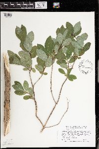 Lonicera oblongifolia (Goldie) Hooker 453137[1397615]Smith, Welby 274921998-08-06 United States, Minnesota, Cook, Boundary Waters Canoe Area Wilderness / Superior National Forest. Cook County ... In the Boundary Waters Canoe Area Wilderness, Superior National Forest ... along the Cross River ... T 65N R 4W SW1/4 of SE1/4 of Sec 27. 065N 04W 27, 48.0802765 -90.7380524 |
MIN:Plants | Lonicera x bella Zabel 906937[]Smith, Welby 308682008-06-01 United States, Minnesota, Wright, Wright County ... On the east side of Clearwater Lake about 3 miles northeast of Annandale ... T121N R27W SW1/4 of SW1/4 of Sec 9. 121N 27W 9, 45.2991667 -94.0930556 |
MIN:Plants | 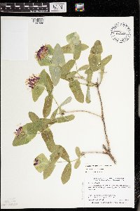 Lonicera dioica var. glaucescens (Rydberg) Butters 505607[1397586]Smith, Welby 277601999-05-19 United States, Minnesota, Winona, Winona County ... About 1/2 mile east of Elba ... T 107N R 10W NE1/4 of NW1/4 of Sec 10;;107N;10W;10, 44.0902786 -92.0102768 |
MIN:Plants | Lonicera x bella Zabel 906783[]Lee, Michael MDL36442004-06-16 United States, Minnesota, Becker, Two Inlets State Forest / White Earth Indian Reservation. Becker County...Two Inlets State Forest...along Indian Creek Forest Road, four miles northeast of Ponsford...T141N R37W NW1/4 of SW1/4 of SW1/4 Sec. 24. 141N 37W 24, 47.00833 -95.24167 |
MIN:Plants | 906052[]Hayes, S.; et al. 102008-11-09 United States, Minnesota, Hennepin, University of Minnesota West Bank...west of W. River Parkway, just south of Washington Avenue, near Mississippi River...cliff behind Anderson Hall.. 029N 23W 25, 44.97176 -93.24209 |
MIN:Plants | Lonicera x bella Zabel 904474[]Smith, Welby 272411998-06-10 United States, Minnesota, Waseca, Waseca County ... St. Olaf Lake County Park, about 4 miles east of New Richland ... T105N R22W NW1/4 of NE1/4 of Sec 13;Saint Olaf Lake County Park;105N;22W;13, 43.9047222 -93.4147222 |
MIN:Plants | Lonicera oblongifolia (Goldie) Hooker 905225[]Smith, Welby 29463A2004-06-24 United States, Minnesota, Beltrami, Beltrami County ... Lake Bemidji State Park ... T147N R33W NW1/4 of NW1/4 of Sec 24;Lake Bemidji State Park;147N;33W;24, 47.5397222 -94.8152778 |
MIN:Plants | Lonicera caerulea var. villosa (Michaux) Torrey & A. Gray 902896[]Smith, Welby 267671997-08-11 United States, Minnesota, Lake, Finland State Forest. Lake County...About 7.5 miles north of Little Marais, where Highway 8 joins Highway 7...along Ninemile Creek...T58N R6W SE1/4 of NE1/4 of Sec 9. 058N 06W 9, 47.525496 -91.089498 |
MIN:Plants | 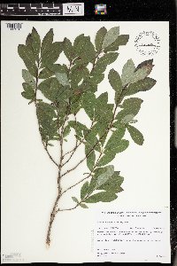 Lonicera oblongifolia (Goldie) Hooker 483678[1397610]Gerdes, Lynden; et al. 30771998-08-06 United States, Minnesota, Cook, Superior National Forest. T65N R04W S26NWSW. Cook County; Superior National Forest. Cross River section between the parking/fishing pulloff along the Gunflint Trail (Hwy. 12) and Cty. 47 (Round Lake road).. 065N 04W 26, 48.084497 -90.803753 |
MIN:Plants | 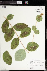 Lonicera hirsuta Eaton 454911[1397593]Gerdes, Lynden 42202000-08-07 United States, Minnesota, Lake, Lake County ... Tettegouche State Park ... approximately .25 mile south of Bean Lake ... T56N R08W S26SESE;North Shore / Tettegouche State Park;056N;08W;26, 47.307427 -91.31451 |
MIN:Plants | Lonicera x bella Zabel 438128[]Smith, Welby 270251998-05-11 United States, Minnesota, Morrison, Charles A Lindbergh State Park. Morrison County...Charles Lindberg State Park. On the west bank of the Mississippi River, about one mile south of Little Falls...T 129N R 30W SE1/4 of NE1/4 of Sec 25. 129N 30W 25, 45.9588889 -94.3911111 |
MIN:Plants | 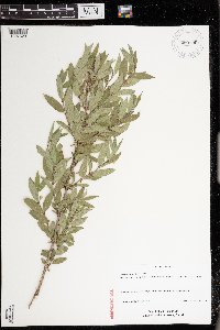 Lonicera x salicifolia Dieck ex Zabel 920190[1397623]Schimpf, D. DJS5902010-05-30 United States, Minnesota, Saint Louis, St. Louis County, Duluth. T49N R15W Sec 34.;;049N;15W;34, 46.6841667 -92.23 |
MIN:Plants | Lonicera x bella Zabel 904496[]Smith, Welby 270171998-05-11 United States, Minnesota, Benton, Benton County...east bank of the Mississippi River, about 2 miles north-northeast of Sartell...T 37N R 31W SW1/4 of NW1/4 of Sec 34. 037N 31W 34, 45.6572222 -94.1913889 |
MIN:Plants | Lonicera x bella Zabel 920234[]Smith, Welby R. 222061993-05-25 United States, Minnesota, Meeker, On the south side of T.H. 12, about 2 miles southeast of Darwin. T119N R30W NW1/4 of SE1/4 of Sec 25, 45.0872222 -94.3916667 |
MIN:Plants | Lonicera x bella Zabel 904485[]Smith, Welby 272441998-06-12 United States, Minnesota, Sherburne, Sand Prairie Wildlife Management Area. Sherburne County ... Sand Prairie State Wildlife Management Area, about 2 miles east of St. Cloud ... T35N R30W SW1/4 of SW1/4 of Sec 4. 035N 30W 4, 45.5486111 -94.0866667 |
MIN:Plants | 913500[]Smith, Welby 243191994-07-02 United States, Minnesota, Polk, Polk County... Along the south side of the Sand Hill River, about 1.5 miles west of Fertile... T147N R44W NE1/4 of SW1/4 of Sec 19. 147N 44W 19, 47.5325 -96.3116667 |
MIN:Plants | Lonicera prolifera (von Kirchner) Booth ex Rehder 438551[]Smith, Welby 259241995-08-31 United States, Minnesota, Wabasha, Carley State Park. Wabasha County...In Carly State Park, about 3 miles south of Plainview, on the north-fork Whitewater River...T 108N R 11W SW1/4 of NW1/4 of Sec 32. 108N 11W 32, 44.1155556 -92.175 |
MIN:Plants | Lonicera morrowii A. Gray 904724[]Smith, Welby 277581999-05-19 United States, Minnesota, Winona, Winona County...About 1/2 mile east of Elba...T 107 R 10W NE1/4 of NW1/4 of Sec 10;;107N;10W;10, 44.0902778 -92.0102778 |
MIN:Plants | Lonicera x bella Zabel 904202[]Smith, Welby 280711999-07-22 United States, Minnesota, Watonwan, Watline Wildlife Management Area. Watonwan County...Watline State Wildlife Management Area, about 2 miles SW of St. James...between Hwy 4, and abandoned railroad tracks...T106N R32W NW1/4 of NE1/4 of Sec 34. 106N 32W 34, 43.9469444 -94.6686111 |
MIN:Plants | Lonicera morrowii A. Gray 913727[]Smith, Welby R. 227711993-07-09 United States, Minnesota, Rock, About 0.5 mile southeast of Luverne; along the Rock River. T102N R45W NE1/4 of SE1/4 of sec 11, 43.650556 -96.196111 |
MIN:Plants | 540954[]Smith, Welby 272821998-06-25 United States, Minnesota, Anoka, Anoka County ... Rum River North County Park, about 7 miles NW of East Bethel ... T 134N R 24W NW1/4 of NE1/4 of Sec 32;Rum River County Park;134N;24W;32, 45.3902779 -93.3550034 |
MIN:Plants | Lonicera canadensis W. Bartram ex Marshall 912992[]Smith, Welby 242381994-06-01 United States, Minnesota, Saint Louis, St. Louis County...McCarthy Beach State Park; on the north side of Sturgeon Lake...T 60N R 21W SW1/4 of SE1/4 of Sec 18;McCarthy Beach State Park;060N;21W;18, 47.6922222 -93.0263889 |
MIN:Plants | 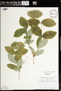 Lonicera dioica var. glaucescens (Rydberg) Butters 480876[1397577]Harris, Fred 990231999-05-26 United States, Minnesota, Brown, Brown County ... Flandrau State Park ... S side of Cottonwood River valley ... T109N R30W, NE1/4 of NE1/4 of NW1/4 Sec 5;Flandrau State Park;109N;30W;05, 44.275804 -94.462061 |
MIN:Plants | Lonicera oblongifolia (Goldie) Hooker 493690[]Gerdes, Lynden 33881999-06-03 United States, Minnesota, Cook, T65N R04W S25SENW Cook County..Superior National Forest; east of the Cross River and north of Cty 12...Adjacent to river;Superior National Forest;065N;04W;25, 48.08417 -90.782109 |
MIN:Plants | 511151[]Bright, R. 76-401976-00-00 United States, Montana, Ravalli, [no further data] |
MIN:Plants | 904490[]Smith, Welby 273681998-07-10 United States, Minnesota, Otter Tail, Bluff Creek Wildlife Management Area. Otter Tail County ... Bluff Creek State Wildlife Management Area, about 11 miles west of Sebeka ... T136N R37W NE1/4 of NW1/4 of Sec 2. 136N 37W 2, 46.6286111 -95.3144444 |
MIN:Plants | 482430[]Gerdes, Lynden 39502000-06-04 United States, Minnesota, Lake, T57N R07W S33SESW. Lake County; Ecbeck Forest Campground, Finland; Banks of the Baptism river just NE of the Hwy 1 bridg;North Shore;057N;07W;33, 47.378895 -91.224886 |
MIN:Plants | 429285[]Smith, Welby 256361995-06-01 United States, Minnesota, Mower, Mower County ... Lake Louise State Park, about 1.5 miles northwest of LeRoy ... T 101N R 14W NW1/4 of NW1/4 of Sec 28;Lake Louise State Park;101N;14W;28, 43.522099 -92.518958 |
MIN:Plants | Lonicera x bella Zabel 917047[]Lee, Michael; et al. MDL40262005-07-14 United States, Minnesota, Becker, Becker County...Along the Otter Tail River just upstream of Frazee...T138N R40W SE1/4 of NE1/4 Sec. 26;;138N;40W;26, 46.737384 -95.699807 |
MIN:Plants | Lonicera canadensis W. Bartram ex Marshall 910954[]Smith, Welby 246111994-07-11 United States, Minnesota, Koochiching, Koochiching County...About 3 miles E of Northome...south side of Tuefer Lake...T 151N R 28W SW1/4 of NE1/4 of Sec 27;;151N;28W;27, 47.8694444 -94.2183333 |
MIN:Plants | 904493[]Smith, Welby 273811998-07-15 United States, Minnesota, Carver, Carver County ... At the west end of Lake Auburn, in Carver Park ... T116N R24W NW1/4 of SW1/4 of Sec 11;Carver Park Reserve County Park;116N;24W;11, 44.8688889 -93.6775 |
MIN:Plants |  Lonicera oblongifolia (Goldie) Hooker 510535[1397614]Gerdes, Lynden 39642000-06-12 United States, Minnesota, Lake, T56N R07W S18SWNW. Lake County ... Tettegouche State Park ... approx. 0.5 mile SW of Tettegouche Lake.;North Shore / Tettegouche State Park;056N;07W;18, 47.336163 -91.272302 |
MIN:Plants | Lonicera dioica var. glaucescens (Rydberg) Butters 904645[]Lee, Michael MDL36452004-06-16 United States, Minnesota, Becker, Two Inlets State Forest / White Earth Indian Reservation. Becker County...Two Inlets State Forest...along Indian Creek Forest Road, four miles northeast of Ponsford...T141N R37W SW1/4 of SW1/4 of SW1/4 Sec. 24. 141N 37W 24, 47.01365 -95.307469 |
MIN:Plants | Lonicera x bella Zabel 493312[]Gerdes, Lynden 46742003-06-02 United States, Minnesota, Lake, Superior National Forest. T60 R10W S17SWNW Lake County ...Superior National Forest. Slate Lake area, approximately 14.22 miles WNW of Isabella MN. Stony River outlet of Slate Lake near its junction with Hwy. 1.. 060N 10W 17, 47.68352 -91.630902 |
MIN:Plants | Lonicera x bella Zabel 918233[]Smith, Welby R. 223601993-06-08 United States, Minnesota, Carver, Carver Park Reserve; about 5 miles west of Chanhassen. T 116N R 24W SE1/4 of NE1/4 of Sec 11, 44.8716667 -93.6644444 |
MIN:Plants | 477204[]Kaul, R.; et al. 67321990-05-24 United States, Minnesota, Steele, Steele County ... along the Straight River, south edge of Owatonna.;;107N;20W;, 44.066112 -93.226071 |
MIN:Plants | Lonicera x bella Zabel 436827[]Smith, Welby 167611990-05-31 United States, Minnesota, Goodhue, Dorer Memorial Hardwood State Forest. Goodhue County...In the Cannon River Valley, about 3 miles east of the town of Cannon Falls...T112N R17W NE1/4 of SE1/4 of Sec 10. 112N 17W 10, 44.521389 -92.8269424 |
MIN:Plants | Lonicera oblongifolia (Goldie) Hooker 438514[]Whitfeld, T.J.S. 5882005-06-10 United States, Minnesota, Clearwater, Clearwater County...On north side of Ponsford Landing; east side of Lower Rice Lake...T145N R38W SWNE35;White Earth Indian Reservation;145N;38W;35, 47.332524 -95.456278 |
MIN:Plants | Lonicera caerulea var. villosa (Michaux) Torrey & A. Gray 912679[]Lee, Michael MDL43712007-06-12 United States, Minnesota, Wadena, Wadena County...wetland complex north-northwest of Strike Lake, two miles south-southeast of Nimrod...T136N R33W SE1/4 of NE1/4 Sec. 8...UTM: 5163691N 356997E. 136N 33W 8, 46.608315 -94.874565 |
MIN:Plants |  Lonicera morrowii A. Gray 428918[1397598]Smith, Welby 279541999-06-29 United States, Minnesota, Chisago, Wild River State Park. Chisago County ... In St. Croix Wild River State Park, about 3 miles NE of Almelund ... St. Croix River ... T 35N R 19W SE1/4 of NE1/4 of Sec 8. 035N 19W 8, 45.5330544 -92.7319412 |
MIN:Plants | 510320[]Lee, Michael MDL23301998-07-31 United States, Minnesota, Crow Wing, Crow Wing Co. ... Along the Mississippi River at the mouth of the Nokasippi River. Fort Ripley Public Water Access off State Hwy 371 one mile north of Fort Ripley ... T43N R32W SE1/4 of NW1/4 Sec. 23. 043N 32W 23, 46.193719 -94.34484 |
MIN:Plants |  462032[1397632]Smith, Welby 272151998-06-06 United States, Minnesota, Anoka, Lamprey Pass Wildlife Management Area. Anoka County ... Lamprey Pass State Wildlife Management Area, about 2 mi southwest of Forest Lake (town) ... T 32N R 22W SW1/4 of NE1/4 of Sec 13. 032N 22W 13, 45.2619438 -93.0294418 |
MIN:Plants | 904477[]Smith, Welby 273601998-07-10 United States, Minnesota, Clearwater, Clearwater County ... At Peace Pipe Springs in Itasca State Park ... T143N R36W SW1/4 of SE1/4 of Sec 12;Itasca State Park;143N;36W;12, 47.2119444 -95.1769444 |
MIN:Plants |  431872[1299498]Godfrey, R. 845341993-04-22 United States, Florida, Taylor, Taylor County ... On road to Hickory Mound, 6 miles S of U.S. Rt. 98. |
MIN:Plants | Lonicera x bella Zabel 438249[]Smith, Welby 273891998-07-15 United States, Minnesota, McLeod, McLeod County...About one mile southeast of Winsted in William May County Park...T 117N R 27W SE1/4 of SW1/4 of Sec 12;William May County Park;117N;27W;12, 44.9505539 -94.0194473 |
MIN:Plants | 905724[]Lee, Michael MDL39212005-06-02 United States, Minnesota, Todd, Todd County...east of U.S. Hwy 71, one mile northeast of the village of Little Sauk, 6.5 mile south of Long Prairie...abandoned gravel pit...T128N R34W SW1/4 of SE1/4 of SE1/4 Sec. 24. 128N 34W 24, 45.882528 -94.901351 |
MIN:Plants | Lonicera canadensis W. Bartram ex Marshall 915912[]Smith, Welby 251561994-08-17 United States, Minnesota, Koochiching, Koochiching County...Along the Rainy River, about 12 miles west of Loman...T 160N R 26W NW1/4 of SE1/4 of Sec 36;;160N;26W;36, 48.6302778 -93.9122222 |
MIN:Plants | Lonicera hirsuta Eaton 462105[]Smith, Welby 284582000-05-25 United States, Minnesota, Beltrami, Beltrami County ... Lake Bemidji State Park ... T 147N R 33W NW1/4 of NW1/4 of Sec 24;Lake Bemidji State Park;147N;33W;24, 47.5397224 -94.8152771 |
MIN:Plants | Lonicera x bella Zabel 427027[]Smith, Welby 280571998-07-22 United States, Minnesota, Cottonwood, Cottonwood County ... About 6 miles N-NE of Heron Lake (town) ... along the Des Moines River ... T 105N R 37W NE1/4 of NW1/4 of Sec 28. 105N 37W 28, 43.8763885 -95.2930527 |
MIN:Plants | Lonicera canadensis W. Bartram ex Marshall 904119[]Smith, Welby 282171999-08-25 United States, Minnesota, Hubbard, Hubbard County...About 5 miles southwest of Laporte...T143N R33W SW1/4 of SW1/4 of Sec 36;Paul Bunyan State Forest;143N;33W;36, 47.1530556 -94.8111111 |
Google Map
Google Maps is a web mapping service provided by Google that features a map that users can pan (by dragging the mouse) and zoom (by using the mouse wheel). Collection points are displayed as colored markers that when clicked on, displays the full information for that collection. When multiple species are queried (separated by semi-colons), different colored markers denote each individual species.