University of Minnesota
http://www.umn.edu/
612-625-5000
http://www.umn.edu/
612-625-5000
Minnesota Biodiversity Atlas
Bell Museum
Dataset: MIN-Plants
Taxa: Amaranthaceae
Search Criteria: excluding cultivated/captive occurrences
Bell Museum plants | |
 MIN:Plants |  630573[1037696]Halse, Richard 7481971-09-03 United States, Arizona, Apache, South Rim around the road leading to Sliding Rock Ruins Overlook, Canyon de Chelly National Monument...Apache County;Canyon de Chelly National Monument, 1981m |
MIN:Plants |  911124[1037668]Smith, Welby 220221992-09-17 United States, Minnesota, Nicollet, Swan Lake Wildlife Management Area. Nicollet County...Swan Lake State Wildlife Management Area - North Star Supplement. About 1.5 miles north-northwest of Judson...T 109N R 28W NE1/4 of SW1/4 of Sec 28. 109N 28W 28, 44.2172222 -94.2033333 |
MIN:Plants |  794826[1037698]Schaaf, J. 341982-07-27 United States, Nevada, Pershing, Pershing Co. ... SR 399 MP 16-17.21 ... Elev.: 4100 ft. |
MIN:Plants |  911713[1037669]Smith, Welby 254231994-09-07 United States, Minnesota, Cass, Cass County...About 0.5 mile north-northeast of Motley...T 133N R 31W SE1/4 of SW1/4 of Sec 7;;133N;31W;07, 46.3508333 -94.6408333 |
MIN:Plants |  105188[1037664]Aiton, G. s.n.1891-09-00 United States, Minnesota, Hennepin, Near Minneapolis.;;N;;, 44.979965 -93.263836 |
MIN:Plants |  105195[1037682]Moyer, Lycurgus s.n.1893-10-03 United States, Minnesota, Swift, Appleton, near rr station;;120N;43W;, 45.195938 -96.04182 |
MIN:Plants |  105208[1122526]Sandberg, John s.n.1890-08-00 United States, Minnesota, Hennepin, [no further data];;;;, 45 -93.47 |
MIN:Plants |  105209[1037726]Aiton, G. s.n.1892-09-00 United States, Minnesota, Hennepin, Near Minneapolis;;029N;24W;, 44.991926 -93.288153 |
MIN:Plants |  105210[1037684]Moyer, Lycurgus s.n.1895-09-00 United States, Minnesota, Chippewa, Montevideo;;117N;40W;, 44.934626 -95.675774 |
MIN:Plants |  105211[1037637]Taylor, B. T11801891-08-00 United States, Minnesota, Pope, Glenwood;;N;;, 45.628525 -95.325191 |
MIN:Plants |  105212[1122527]Sandberg, John s.n.1891-08-00 United States, Minnesota, Crow Wing, [no further data];;;;, 46.482372 -94.070879 |
MIN:Plants |  105213[1037645]Sheldon, Edmund S11961891-07-00 United States, Minnesota, Brown, New Ulm;;110N;30W;, 44.326359 -94.431802 |
MIN:Plants | 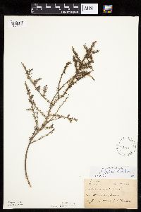 105214[1037692]Sheldon, Edmund S20041892-06-00 United States, Minnesota, Crow Wing, Brainerd;;N;;, 46.358022 -94.200829 |
MIN:Plants | 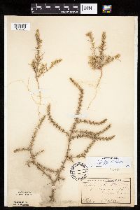 105215[1037661]Sheldon, Edmund S74251892-09-00 United States, Minnesota, Traverse, Lake Traverse;;N;;, 45.691689 -96.743775 |
MIN:Plants | 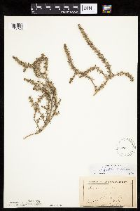 105216[1037653]Menzel, Max s.n.1892-08-00 United States, Minnesota, Pipestone, Pipestone City;;106N;46W;12, 44.00136 -96.31763 |
MIN:Plants | 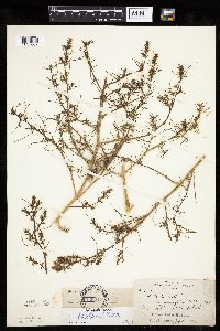 105217[1037662]Skinner, S. 2811902-07-03 United States, Minnesota, Jackson, Heron Lake. Along r.r. W of lake.;;N;;, 43.793292 -95.291942 |
MIN:Plants |  105218[1037724]Moyer, Lycurgus s.n.1895-08-08 United States, Minnesota, Pope, Soo Station. Glenwood.;;;;, 45.628525 -95.325191 |
MIN:Plants |  105222[1037636]Moyer, Lycurgus s.n.1895-08-08 United States, Minnesota, Pope, Soo Station. Glenwood.;;N;;, 45.628525 -95.325191 |
MIN:Plants |  105223[1037725]Moyer, Lycurgus s.n.1895-09-00 United States, Minnesota, Chippewa, Montevideo;;117N;40W;, 44.934626 -95.675774 |
MIN:Plants |  105224[1037663]Aiton, G. s.n.1891-09-00 United States, Minnesota, Hennepin, Minneapolis;;N;;, 44.979965 -93.263836 |
MIN:Plants |  105225[1037723]Sandberg, John s.n.1890-09-00 United States, Minnesota, Hennepin, Minneapolis;;029N;24W;25, 44.969959 -93.237021 |
MIN:Plants |  267183[1037674]Anonymous 911912-06-00 United States, Minnesota, Kandiyohi, Willmar;;N;;, 45.110139 -95.062995 |
MIN:Plants |  277567[1037644]Jones, Percy 4241930-08-24 United States, Minnesota, Beltrami, Near Bemidji Lake, Bemidji;;N;;, 47.506113 -94.850917 |
MIN:Plants |  277568[1037630]Hotchkiss, N.; et al. 5061930-09-11 United States, Minnesota, Hennepin, Sec. 33 or 34, Eden Prairie Twp. Hennepin Co.;;116N;22W;00, 44.847935 -93.459722 |
MIN:Plants |  337650[1037683]Lakela, Olga 16331936-08-06 United States, Minnesota, Saint Louis, Oatka Beach Addition at 42nd Street, Duluth;Minnesota Point;049N;13W;18, 46.74205 -92.06285 |
MIN:Plants |  348961[1037695]Nielsen, E. 17651932-10-10 United States, Minnesota, Hennepin, Old rock quarry just east of Botany Bldg - on University of Minn. campus. Minneapolis.;;029N;24W;25, 44.969959 -93.237021 |
MIN:Plants |  353194[1037671]Eneboe, H. 581937-07-14 United States, Minnesota, Ramsey, Midway district, St. Paul.;;029N;23W;, 44.992077 -93.166387 |
MIN:Plants |  353946[1037656]Moyle, J. 14411934-07-11 United States, Minnesota, Hubbard, Along road between Itasca Park and Park Rapids;;N;;, 47.050472 -95.127873 |
MIN:Plants |  359302[1037678]Alaspa, E.; Alaspa, H. s.n.1940-07-26 United States, Minnesota, Carlton, 1 1/2 mi. S of Cloquet.;;049N;17W;, 46.721919 -92.491717 |
MIN:Plants |  367006[1037686]Moore, John; Butters, F. 135251940-09-05 United States, Minnesota, Cass, S shore of Leech Lake, 1/2 mi E of Whipholt;Chippewa National Forest / Leech Lake Indian Reservation;141N;29W;, 47.022752 -94.346119 |
MIN:Plants |  370644[1037628]Moore, John; Moore, Marjorie 136951940-09-29 United States, Minnesota, Dakota, S shore of Lake Marion. Dakota Co.;;N;;, 44.665556 -93.2825 |
MIN:Plants |  370680[1037685]Moore, John; Moore, Marjorie 136481940-09-28 United States, Minnesota, Ramsey, Ramsey Co.; SE1/4 Sec. 8 Mounds View Twp.;;030N;23W;8, 45.100763 -93.198544 |
MIN:Plants |  409202[1037629]Moore, John; Moore, Marjorie 113691939-08-02 United States, Minnesota, Roseau, 1.3 mi. N of Longworth.;;N;;, 48.993543 -95.365029 |
MIN:Plants |  412953[1037676]Moore, John; Moore, Marjorie 114881939-08-07 United States, Minnesota, Kittson, At the town of Noyes;;N;;, 48.9975 -97.204167 |
MIN:Plants |  427899[1037633]Jones, George Neville 187451946-08-15 United States, Minnesota, Saint Louis, Armstrong Lake, near Ely.;;062N;14W;, 47.844609 -92.115349 |
MIN:Plants |  429833[1037651]Smith, Welby 210721992-07-23 United States, Minnesota, Le Sueur, Le Sueur Co.; About one mile east of Elysian, on the north sid eof Highway 60; T 109N R 23W SW1/4 of SW1/4 of Sec 31 Le Sueur Co.; About one mile east of Elysian, on the north sid eof Highway 60; T 109N R 23W SW1/4 of SW1/4 of Sec 31.. 109N 23W 31, 44.1983337 -93.6436081 |
MIN:Plants |  439610[1037688]Smith, Welby 162701989-08-29 United States, Minnesota, Chisago, Chisago Co. Spring Hill Park in the city of Branch; SE1/4 NW1/4 sec.15, T35N R21W;;035N;21W;15, 45.521061 -92.949958 |
MIN:Plants |  456601[1037694]Smith, Welby 210001992-07-16 United States, Minnesota, Pennington, Pennington County...On the W side of County Road 73, about 4.5 mi NW of the center of Thief River Falls...bandoned gravel pit...T154N R44W NE1/4 of NE1/4 of Sec 13. 154N 44W 13, 48.1638889 -96.2405556 |
MIN:Plants |  457115[1037687]Smith, Welby 137921987-08-11 United States, Minnesota, Washington, Washington Co. About 3 mi NW of Afton; SW1/4 NE1/4 sec.4, T28N R20W;;028N;20W;4, 44.941687 -92.81216 |
MIN:Plants |  507597[1037639]Lee, Michael MDL7861994-08-08 United States, Minnesota, Fillmore, Fillmore County...SW-facing slope 1/2 mi WNW of Rushford...T104N R8W SE1/4 of NE1/4 of Sec 15;;104N;08W;15, 43.810558 -91.780233 |
MIN:Plants |  520268[1037679]Smith, Welby 177741990-08-07 United States, Minnesota, Red Lake, Marcoux Wildlife Management Area. Red Lake Co.; in Marcoux State Wildlife Management Area, about 5 mi W-SW of Terrebonne; Red Lake Co.; in Marcoux State Wildlife Management Area, about 5 mi W-SW of Terrebonne; T150N R44W SE1/4 of NE1/4 of Sec 24. 150N 44W 24, 47.793335 -96.2202759 |
MIN:Plants |  526428[1037691]Moore, John 21239a1951-08-07 United States, Minnesota, Traverse, 2 mi. SW of Wheaton.;;N;;, 45.783925 -96.528607 |
MIN:Plants |  542327[1037658]Moore, John 213521951-08-10 United States, Minnesota, Grant, 3 mi E of Elbo Lake;;N;;, 45.99076 -95.96249 |
MIN:Plants |  550135[1037681]Moore, John; et al. 222931954-09-22 United States, Minnesota, Lincoln, Lincoln County...W bluff of Dead Coon Lake;;110N;44W;01, 44.36222 -96.09611 |
MIN:Plants |  558574[1037635]Moore, John 236611957-09-26 United States, Minnesota, Clay, 5 1/2 mi. NE of Barnesville.;;N;;, 46.708455 -96.337767 |
MIN:Plants |  568592[1037621]Moore, John 248861959-09-29 United States, Minnesota, Blue Earth, Blue Earth County...shore of the Blue Earth River 1-1/2 mi S of Mankato;;;;, 44.149384 -94.032277 |
MIN:Plants |  572593[1037672]Moore, John 256631961-06-28 United States, Minnesota, Isanti, NW corner of Cedar Creek Natural History Area.;Cedar Creek National History Area;034N;23W;, 45.428063 -93.203997 |
MIN:Plants |  572988[1037650]Stevens, O. 26261962-08-22 United States, Minnesota, Clay, N of hwy 10, old gravel pit;<No data>;139N;46W;03, 46.883642 -96.473509 |
MIN:Plants | 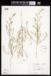 574752[1037642]Moore, John 247331959-07-29 United States, Minnesota, Kittson, Along the roadside W line of Bronson State Park;Lake Bronson State Park;161N;46W;, 48.760365 -96.602054 |
MIN:Plants | 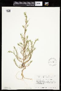 584584[1037670]Ownbey, Gerald 36031963-07-30 United States, Minnesota, Becker, Becker Co. Along Hwy. 113, ca. 3.0 mi. W of its jct. with Hwy. 71, opposite the entrance to De Soto Lake. T142N, R36W, Becker Co. Along Hwy. 113, ca. 3.0 mi. W of its jct. with Hwy. 71, opposite the entrance to De Soto Lake. T142N, R36W, NW1/4 Sec. 11.. 142N 36W 11, 47.130783 -95.201396 |
MIN:Plants | 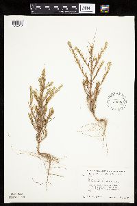 585662[1037643]Moore, John 261331962-08-13 United States, Minnesota, Anoka, Along the roadside, Cedar Creek Natural History Area; NW1/4 Sec. 33 Bethel Twp.;Cedar Creek National History Area;034N;23W;33, 45.392178 -93.213974 |
MIN:Plants | 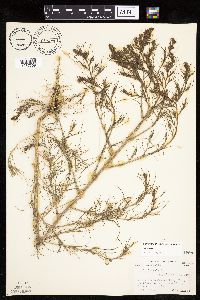 589079[1037659]Abbott, Robinson s.n.1961-07-25 United States, Minnesota, Stevens, Stevens County...S. Pomme de Terre [=Perkins] Lake N. of Morris on rt. 59.;;126N;41W;00, 45.716134 -95.820225 |
MIN:Plants |  592448[1037657]Westkaemper, Remberta s.n.1964-00-00 United States, Minnesota, Stearns, Stearns Co. St. Joseph, around building under constructure;;124N;29W;, 45.543642 -94.322053 |
MIN:Plants |  595345[1037634]Cahoon, E. 721956-07-08 United States, Minnesota, Brown, At Och's Clay pit ca. 1 mi. SW of Springfield.;;N;;, 44.228606 -94.990117 |
MIN:Plants |  602166[1037646]Westkaemper, Remberta s.n.1966-08-00 United States, Minnesota, Stearns, Stearns Co. SBC [St. Benedict's College] waste area, St. Joseph;;124N;29W;, 45.543642 -94.322053 |
MIN:Plants |  672652[1037638]Wheeler, Gerald 8691976-08-02 United States, Minnesota, Houston, Houston Co. Brownsville, Wildcat Landing, adjacent to the beach at the landing on the W shore of the Mississippi River;Upper Mississippi National Wildlife Refuge;103N;04W;, 43.71854 -91.317395 |
MIN:Plants |  685107[1037673]Stassen, Carol 1561977-06-27 United States, Minnesota, Lyon, Camden State Park, gravel pits; T110N R42W Sec. 5 SE1/4;Camden State Park;110N;42W;5, 44.363181 -95.927443 |
MIN:Plants |  687517[1037675]Wheeler, Gerald; Glaser, Paul 19591977-07-09 United States, Minnesota, Itasca, Chippewa National Forest / Leech Lake Indian Reservation. Itasca Co.; Collection Site no. 99, ca. 21 mi WNW of Grand Rapids, just E of where the rr tracks cross the Mississippi R Itasca Co.; Collection Site no. 99, ca. 21 mi WNW of Grand Rapids, just E of where the rr tracks cross the Mississippi River (E bank); NE1/4 NW1/4 Sec. 3 T145N R26W. 145N 26W 3, 47.404599 -93.956013 |
MIN:Plants |  695794[1037625]Clemants, Steven 9561977-10-08 United States, Minnesota, Crow Wing, Crow Wing County...Pelican Lake, Sunset Beach. 13 mi. N of Brainerd. Sec. 35 & 36, T136N, R28W.;;136N;28W;35, 46.551903 -94.172468 |
MIN:Plants |  696556[1037652]Smith, Welby 8441978-08-26 United States, Minnesota, Wright, Ca. 3 mi NW of Monticello, between Burlington tracks and co. 75; T122N R25W N1/2 Sec. 32;;122N;25W;32, 45.331907 -93.860001 |
MIN:Plants |  704578[1037665]Smith, Welby 16301979-08-16 United States, Minnesota, Wabasha, T109N, R09W, NE1/4 SW1/4 Sec. 7. 20 m due E of Co. Rd. 84.;;109N;09W;7, 44.258106 -91.93891 |
MIN:Plants |  710047[1037626]Wheeler, Gerald 50771979-10-06 United States, Minnesota, Le Sueur, East Minnesota River Wildlife Management Area. Le Sueur County...Approx. 1 mi SW of Kasota...bluff overlooking the Minnesota River. High Lime Prairie. T109N, R26W, Sec. 6.. 109N 26W 6, 44.274575 -93.998474 |
MIN:Plants |  720253[1037655]Ottoson, S. 1731979-08-27 United States, Minnesota, Agassiz Dunes Scientific Natural Area. Polk and Norman Counties...Agassiz Dunes...2 miles southwest of Fertile, Sec. 31,32, T149N [sic; should be T147], R44W; Sec. 5,6, T146N R44w. , 47.504423 -96.296765 |
MIN:Plants |  721356[1037680]Benson, Douglas 201980-08-25 United States, Minnesota, Saint Louis, Great Lake Iron and Steel, Duluth;;;;, 46.783273 -92.106579 |
MIN:Plants |  721471[1037654]Farrell, P. 1651979-08-02 United States, Minnesota, Polk, 7 mi. SE of Crookston. S1/2 of section;Pankratz Memorial Prairie, The Nature Conservancy;149N;45W;08, 47.73852 -96.44879 |
MIN:Plants |  722661[1037632]Lustig, K. 8991979-08-13 United States, Minnesota, Anoka, 18 mi. SE of Cambridge.;Boot Lake Scientific Natural Area;033N;22W;, 45.34066 -93.08146 |
MIN:Plants |  730597[1037666]Petron, T. 661980-06-09 United States, Minnesota, Wilkin, Western Prairie South, 6.5 mi NW of Rothsay, edge of E boundary near cultivated field; NE1/4 NW1/4 Sec. 12 T135N R46W;Western Prairie South Scientific Natural Area;135N;46W;12, 46.521816 -96.414416 |
MIN:Plants |  734687[1037690]Petron, T. 3111980-08-12 United States, Minnesota, Clay, Bluestem Prairie: 13 mi. E of Moorhead. SW1/4 SE1/4 Sec. 15, T139N, R46W.;Bluestem Prairie Scientific Natural Area;139N;46W;15, 46.854948 -96.473403 |
MIN:Plants |  738050[1037627]Sorenson, Spencer 37A1962-09-27 United States, Minnesota, Saint Louis, St. Louis Cty, R13, T49N, Minnesota Point: beyond the amusement park.;Minnesota Point;049N;13W;18, 46.74205 -92.06285 |
MIN:Plants |  739527[1037631]Stackler, S. 2210A1976-09-09 United States, Minnesota, Carlton, Carlton Co. 5. Just N of Jct. with Carlton Co. 6. T46, R17W, S30.;;046N;17W;30, 46.439704 -92.541512 |
MIN:Plants |  745485[1037641]Smith, Welby 50001981-07-21 United States, Minnesota, Mower, Wild Indigo Scientific and Natural Area, ca. 2.5 mi W of Dexter; SW1/4 NE1/4 Sec. 16 T103N R16W;Wild Indigo Scientific Natural Area;103N;16W;16, 43.724883 -92.759467 |
MIN:Plants |  751006[1037647]Galatowitsch, S. 8741983-08-13 United States, Minnesota, Wabasha, NE1/4 NW1/4 Sec. 6 T109N R9W;;109N;09W;6, 44.272608 -91.938983 |
MIN:Plants |  770223[1037649]Smith, Welby 86931983-08-16 United States, Minnesota, Wabasha, Kellogg-Weaver Dunes Scientific Natural Area / Kellogg-Weaver Dunes, The Nature Conservancy. Kellogg-Weaver Dunes State Scientific and Natural Area, ca. 4 mi SE of Kellogg, on the E side of co. rd 84; SW1/4 NE1/4 Kellogg-Weaver Dunes State Scientific and Natural Area, ca. 4 mi SE of Kellogg, on the E side of co. rd 84; SW1/4 NE1/4 Sec. 6 T109N R9W. 109N 09W 6, 44.272608 -91.938983 |
MIN:Plants |  772877[1037623]Boe, J. 14811979-08-14 United States, Minnesota, Lake of the Woods, Tomato Creek. NW1/4 Sec. 10, R34W, T161N. Near creek under rr bridge.;;161N;34W;10, 48.778711 -95.013451 |
MIN:Plants |  814661[1037624]Wheeler, Gerald 115841988-07-28 United States, Minnesota, Big Stone, Ca. 10.5 mi N of Correll, SW of rte 10, between Artichoke Lake and road; NE1/4 Sec. 14 T122N R44W (Artichoke Twp.);;122N;44W;14, 45.377147 -96.148127 |
MIN:Plants |  816183[1037689]Wheeler, Gerald 114131988-07-25 United States, Minnesota, Lac Qui Parle, Lac Qui Parle State Park. Ca. 15 mi. N of Madison; Lac Qui Parle State park, NE of Rte. 33. Near the parking lot for beach access. N1/2 E1/2 Se Ca. 15 mi. N of Madison; Lac Qui Parle State park, NE of Rte. 33. Near the parking lot for beach access. N1/2 E1/2 Sec. 15, T118N, R42W (Lac Qui Parle Twp.).. 118N 42W 15, 45.029904 -95.909318 |
MIN:Plants |  816600[1037648]Masengarb, J. s.n.1990-09-10 United States, Minnesota, Ramsey, Ramsey Co.; Near jnc of Raymond Ave. and Kasota Ave, St. Paul;;029N;23W;, 44.992077 -93.166387 |
MIN:Plants |  828216[1037622]Dana, R. 910681991-09-13 United States, Minnesota, Kittson, Kittson County...NE1/4 NW1/4 Sec.25 T162N R46W;;162N;46W;25, 48.8319444 -96.5519444 |
MIN:Plants |  840535[1037677]Smith, Welby 136271987-07-30 United States, Minnesota, Washington, Grey Cloud Dunes Scientific Natural Area. Washington County...About 2 mi south of St. Paul Park...SW-facing terrace of the Mississippi River SW1/4 SW1/4 sec. 29, T 27N R 21W. 027N 21W 29, 44.7933333 -92.9625 |
MIN:Plants |  842804[1037693]Myhre, K. 39471993-06-26 United States, Minnesota, Pine, Pine Co. Located near the town of Pine City; T39N R21W SW1/4 of SE1/4 of Sec 33.;;039N;21W;33, 45.824592 -92.970518 |
MIN:Plants |  794730[1037697]Schaaf, J. 201983-10-04 United States, Nevada, Churchill, Churchill Co. ... Sand Mountain ... near Frenchman, 1463m |
MIN:Plants |  492551[1037660]Wheeler, Gerald 174851997-08-31 United States, Minnesota, Renville, Renville County ... W side of Bird Island, N side of Rte. 212; railroad prairie strip ... N1/2 NW1/4 Sec. 14 T115N R34W;;115N;34W;14, 44.767523 -94.905151 |
MIN:Plants |  478917[1037667]Swanson, Scott 21242001-08-09 United States, Minnesota, Sherburne, Sherburne National Wildlife Refuge;Sherburne National Wildlife Refuge;;;, 45.515 -93.71028 |
MIN:Plants |  933491[1122525]Smith, Welby R. 213451992-08-11 United States, Minnesota, Marshall, About 5 miles west of Middle River (town), on the north side of CSAH 6. SW1/4 of SW1/4 of section;;157N;44W;01, 48.4097222 -96.275 |
MIN:Plants |  933915[1122528]Smith, Welby R. 214331992-08-12 United States, Minnesota, Marshall, About 11 miles east of Argyle. NW1/4 of SE1/4 of section;Old Mill State Park;156N;46W;04, 48.3602778 -96.5702778 |
MIN:Plants |  934315[1122529]Smith, Welby R. 214571992-08-12 United States, Minnesota, Pennington, About 16 miles southwest of Thief River Falls. NW1/4 of SE1/4 of section;Pembina Wildlife Management Area;152N;45W;18, 47.9838889 -96.4658333 |
MIN:Plants |  934338[1122530]Smith, Welby R. 214961992-08-12 United States, Minnesota, Pennington, About 16 miles southwest of Thief River Falls SE of NE of section;Pembina Wildlife Management Area;152N;45W;18, 47.9880556 -96.4638889 |
MIN:Plants |  934343[1122531]Smith, Welby R. 215051992-08-13 United States, Minnesota, Roseau, On the north side of TH 11, about 8 miles west-southwest of Greenbush. NW1/4 of NE1/4 of section;;T160N R44W S29, 48.652872 -96.355271 |
MIN:Plants |  953729[1294577]Mierow, Dorothy s.n. United States, New Mexico, San Juan |
MIN:Plants |  953731[1294578]Thomas, Barbara s.n. United States, Montana, Yellowstone |
MIN:Plants |  953730[1294579]Friesner, Ray C. 10116 United States, Indiana, Cass |
MIN:Plants |  Amaranthus powellii S. Watson 431959[1343706]Juhnke, C. 522 CMJ FRO1999-08-17 United States, Minnesota, Goodhue, Frontenac State Park. Goodhue County ... below north slope of Rattlesnake Bluff ... T 112N R 13W NE NW NE 5;Frontenac State Park;112N;13W;05, 44.535196 -92.399973 |
MIN:Plants | Amaranthus powellii S. Watson 758699[]Smith, Welby 71181982-08-07 United States, Minnesota, Wright, Wright County ... About 1.25 mi south of Hasty, on the shoulder of County Highway 8 ... NW1/4 NW1/4 S28, T 122N, R 26W;;122N;26W;28, 45.347582 -93.962927 |
MIN:Plants | Amaranthus powellii S. Watson 518734[]Darveaux, B. s.n.1991-07-30 United States, Minnesota, Steele, Owatonna, Steele Co. Rt 14 heading east off of Hwy 35, near 176 mile marker on left side of road;;107N;20W;, 44.066112 -93.226071 |
MIN:Plants | Amaranthus powellii S. Watson 708360[]Ownbey, Gerald 6495-31979-09-16 United States, Minnesota, Freeborn, Freeborn County ... Albert Lea Albert Lea. , 43.648013 -93.368266 |
MIN:Plants | Amaranthus powellii S. Watson 568904[]Moore, John 253061960-09-28 United States, Minnesota, Blue Earth, Blue Earth County ... Growing along river 1 mile east of Goodthunder;;106N;27W;, 43.978398 -94.068413 |
MIN:Plants | Amaranthus powellii S. Watson 619859[]Ownbey, Gerald 43981970-09-17 United States, Minnesota, Hennepin, Hennepin County ... Along railroad track, N end of Univ. of Minnesota campus, Minneapolis;;029N;24W;, 44.991926 -93.288153 |
MIN:Plants |  Amaranthus powellii S. Watson 695773[1343707]Clemants, Steven 9471977-09-17 United States, Minnesota, Crow Wing, Crow Wing County... Crosslake, roadside on W side of lake, T137N, R27W, NW1/4 S30;;137N;27W;30, 46.653138 -94.145909 |
MIN:Plants |  Amaranthus powellii S. Watson 708236[1343708]Ownbey, Gerald 6495-111979-09-16 United States, Minnesota, Freeborn, Freeborn County ... Albert Lea;;;;, 43.648013 -93.368266 |
MIN:Plants | Amaranthus powellii S. Watson 708240[]Ownbey, Gerald 6495121979-09-16 United States, Minnesota, Freeborn, Albert Lea;;N;;, 43.648013 -93.368266 |
Google Map
Google Maps is a web mapping service provided by Google that features a map that users can pan (by dragging the mouse) and zoom (by using the mouse wheel). Collection points are displayed as colored markers that when clicked on, displays the full information for that collection. When multiple species are queried (separated by semi-colons), different colored markers denote each individual species.