University of Minnesota
http://www.umn.edu/
612-625-5000
http://www.umn.edu/
612-625-5000
Minnesota Biodiversity Atlas
Bell Museum
Dataset: MIN-Plants
Search Criteria: USA OR United States OR U.S.A. OR United States of America; excluding cultivated/captive occurrences
Bell Museum plants | |
 MIN:Plants | 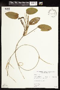 479772[1149330]Gerdes, Lynden B. 29851998-07-18 United States, Minnesota, Cook, T64N R03E S11NENW. Cook County; Superior National Forest, BWCAW. Royal Lake.;Boundary Waters Canoe Area Wilderness / Superior National Forest;064N;03E;11, 48.043397 -90.022127 |
MIN:Plants | 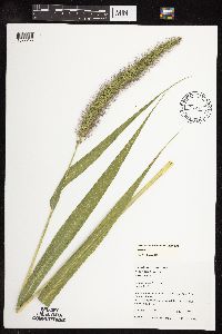 Setaria faberi R.A.W. Herrmamm 438603[1072256]Juhnke, C. 188 CMJ FRO2000-08-10 United States, Minnesota, Goodhue, Frontenac State Park Goodhue County ... 0.3 mile SW of Contact Station ... T112N R13W NE NE SW 11;Frontenac State Park;112N;13W;11, 44.520016 -92.33874 |
MIN:Plants | Thalictrum dasycarpum Fischer & Av̩ Lallemant 914996[]Smith, Welby 226591993-07-01 United States, Minnesota, Otter Tail, Otter Tail County ... North side of CSAH 38; 0.8 mile east of its junction with TH 78, and about 11 miles south of Battle Lake (town) ... T131N R40W SE1/4 of SE1/4 of Sec 22. 131N 40W 22, 46.1380556 -95.6908333 |
MIN:Plants | 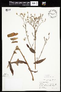 428476[1047597]Olson, Raymond s.n.1941-08-12 United States, Minnesota, Clearwater, Clearwater Co, Itasca State Park, along north arm of Lake Itasca and near picnic grounds.;Itasca State Park;143N;36W;, 47.19557 -95.233216 |
MIN:Plants | 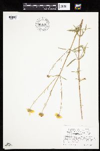 Heliomeris multiflora var. nevadensis (A. Nelson) W.F. Yates 678574[1046426]Tucker, J. 39781966-07-09 United States, California, Inyo, Thorndyke Camp, Wild Rose Canyon, Panamint Mountains, Inyo County;Death Valley National Park, 2286m |
MIN:Plants | Frasera albomarginata S. Watson 499204[]Went, F. s.n.1966-09-00 United States, Nevada, Nye, Quinn Canyon, Cherry Creek |
MIN:Plants |  Oryzopsis asperifolia Michaux 911004[1069171]Smith, Welby 245871994-07-11 United States, Minnesota, Koochiching, Koochiching County...About 3 miles E of Northome...south side of Tuefer Lake...T 151N R 28W SW1/4 of NE1/4 of Sec 27;;151N;28W;27, 47.8694444 -94.2183333 |
MIN:Plants | Moneses uniflora (L.) A. Gray 444419[]Lawrence, Donald s.n.1953-08-19 United States, Alaska, Sebree Island.;Glacier Bay National Park;;;, 58.767611 -136.16222 |
MIN:Plants |  455110[1066103]Gerdes, Lynden; et al. 28951998-07-09 United States, Minnesota, Cook, T65N R03E S33SWNW. Cook County ... Superior National Forest, BWCAW. East Pike Lake and John Lake portage.;Boundary Waters Canoe Area Wilderness / Superior National Forest;065N;03E;33, 48.071844 -90.06797 |
MIN:Plants |  Lactuca biennis (Moench) Fernald 436061[1047388]Smith, Michael 2601996-08-28 United States, Minnesota, Koochiching, Kabetogama State Forest. Voyageurs National Park. Koochiching Co.; Plot name: Voya 32 DNR # 5790; 48 32'02' N 93 13'27' W [this locale is not within the National Park]. 070N 22W , 48.5338898 -93.2241669 |
MIN:Plants | 505409[]Smith, Welby 274881998-08-04 United States, Minnesota, Cook, Cook County...On the north side of Big Susie Island in Lake Superior...T 64N R 7E SE1/4 of SE1/4 of Sec 32;North Shore / Susie Islands, The Nature Conservancy;064N;07E;32, 47.9783333 -89.5741667 |
MIN:Plants |  Potentilla tridentata Aiton 669759[1029471]Wheeler, Gerald s.n.1975-08-05 United States, Minnesota, Lake, Lake County...Twin Points Resort; approx. one-half way between Silver Bay and Two Harbors;North Shore;054N;09W;13, 47.141393 -91.444154 |
MIN:Plants | Lewisia cotyledon (S. Watson) B.L. Robinson 238350[]Congdon, J. s.n.1883-05-31 United States, California, Mariposa, Hite's Cove and Yosemite Trail, Mariposa County;Yosemite National Park |
MIN:Plants |  Lomatium triternatum (Pursh) J.M. Coulter & Rose 794631[1035078]Schaaf, J. 3111982-07-12 United States, Nevada, Humboldt, Pine Forest Range, 1859m |
MIN:Plants |  Muhlenbergia pauciflora Buckley 283315[1068770]Moore, J.; et al. 36271931-07-25 United States, Texas, Culberson, Guadalupe Mountains, Culberson County...ridge above McKittrick Canyon;Guadalupe Mountains National Park, 2425m |
MIN:Plants | Goodyera pubescens (Willdenow) R. Brown 509658[1310712]Myhre, K. United States, Minnesota, Aitkin, Detailed locality information protected. This is typically done to protect rare or threatened species localities. |
MIN:Plants |  473600[1089362]Nation, R. 94-1391994-06-21 United States, Minnesota, Mower, Lake Louise State Park. Mower Co.; Tract #22A. T101N R14W NE1/4 of Sec. 21;Lake Louise State Park;101N;14W;21, 43.536579 -92.519043 |
MIN:Plants |  Salix humilis Marshall 508806[1091128]Smith, Welby; et al. 2724801998-08-05 United States, Minnesota, Cook, Cook County ... At the far western tip of Susie Island, in Lake Superior ... T63N R 7E NW1/4 of SW1/4 of sec 5;North Shore / Susie Islands, The Nature Conservancy;063N;07E;05, 47.9677778 -89.5888889 |
MIN:Plants |  Carex blanda Dewey 426803[1007591]Wheeler, Gerald 199841999-06-11 United States, Minnesota, Carver, Carver County ... Ca. 2 mi. NW of Victoria on Rte. 11; Carver Park Reserve ... SW1/4 Sec. 2 T116N R24W (Laketown 2);Carver Park Reserve County Park;116N;24W;2, 44.884273 -93.672712 |
MIN:Plants |  Poa saltuensis Fernald & Wiegand 904419[1071605]Perry, Ethan 20060252006-07-21 United States, Minnesota, Itasca, Itasca County...10 miles E of Suomi near south end of BeeCee Lake...T58N R25W Sec33;Chippewa National Forest;058N;25W;33, 47.464667 -93.524205 |
MIN:Plants | Viburnum rafinesquianum J.S. Schultes 477476[]Smith, Welby 291682001-06-02 United States, Minnesota, Wright, Wright County ... Harry Larson County Forest, about 7 miles W-NW of Monticello ... T 122N R 26W SW1/4 of SW1/4 of Sec 35;Harry Larson County Forest;122N;26W;35, 45.3352778 -93.9280556 |
MIN:Plants |  129124[1028865]Sheldon, Edmund S.38141892-08-00 United States, Minnesota, Otter Tail, Pelican Lake, Otter Tail Co.;;137N;42W;00, 46.699403 -96.02061 |
MIN:Plants | Parthenocissus quinquefolia (L.) Planchon 462084[]Smith, Welby 259261995-09-01 United States, Minnesota, Scott, Scott County ... at the rest stop on south-bound I35 just north of the Scott-Rice County line ... T 133N R 21W NE1/4 of SE1/4 of sec 35. 113N 21W 35, 44.548487 -93.303473 |
MIN:Plants |  Epilobium luteum Pursh 510297[1137535]Lee, Michael MDL23461998-08-05 United States, Minnesota, Stearns, Stearns County ... Viking Scout Camp ... southwest of Clearwater Lake 2-1/2 miles east-southeast of Fairhaven ... T121N R28W NE1/4 of NW1/4 Sec. 11. 121N 28W 11, 45.3017144 -94.1721094 |
MIN:Plants |  499710[1083373]Scott, P. 12622000-07-14 United States, Minnesota, Cook, Cook Co ... By W. Pike/E. Pike Lakes Portage, BWCAW. T65N R2E sec.27 NESESE.;Boundary Waters Canoe Area Wilderness / Superior National Forest;065N;02E;27, 48.08566 -90.176888 |
MIN:Plants |  Spiraea tomentosa var. rosea (Rafinesque) Fernald 454356[1033488]Myhre, K. 72551997-08-22 United States, Minnesota, Kanabec, Kanabec County ... Thirteen Lake. Located one half mile southeast of Lake Eleven ... northwest end of the lake ... T 42N R 22W NE1/4 of NW1/4 of Sec 13. 042N 22W 13, 46.12195 -93.06479 |
MIN:Plants |  459961[1028691]Mensing, D. 96-2331996-07-15 United States, Minnesota, Carlton, Carlton Co, T48N R21W NE1/4 of the NE1/4 of S4; Tamarack River;;048N;21W;4, 46.677791 -93.004525 |
MIN:Plants | Crataegus douglasii Lindley 902981[1025918]Smith, Welby United States, Minnesota, Cook, Detailed locality information protected. This is typically done to protect rare or threatened species localities. |
MIN:Plants | Cerastium nutans Rafinesque 247220[]Waldron, Clarence 531912-05-26 United States, North Dakota, Dickenson [Dickinson, ND?], 46.879176 -102.789624 |
MIN:Plants |  Potentilla tridentata Aiton 129546[1029550]Sandberg, John s.n.1885-06-00 United States, Minnesota, Carlton, North Pacific plant [possibly in Carlton Co.], 46.66466 -92.424744 |
MIN:Plants |  794615[1004507]Schaaf, J. 1211983-09-20 United States, California, Mono, Hoover Wilderness Area, south shore of West Lake, 3048m |
MIN:Plants | Maianthemum racemosum (L.) Link 454537[]Arboretum, Cary 73-431973-00-00 United States, District of Columbia, Washington ... cultivated |
MIN:Plants | 439153[]Smith, Welby 260291996-06-22 United States, Minnesota, Nobles, Nobles County ... At the public access at the north end of West Graham Lake ...T104N R39W SW1/4 of SW1/4 of Sec 15;Maka Oca County Park;104N;39W;15, 43.8091667 -95.5108333 |
MIN:Plants | 441166[]Scott, P. United States, Minnesota, Lake, Detailed locality information protected. This is typically done to protect rare or threatened species localities. |
MIN:Plants |  Populus tremuloides Michaux 488059[1093140]Smith, Welby 151351989-05-21 United States, Minnesota, Mille Lacs, Kunkel Wildlife Management Area. Mille Lacs County ... Kunkel State Wildlife Management Area, about 4/5 miles west of Princeton...SW1/4 SE1/4 section 26, T36N R27W. 036N 27W 26, 45.5763889 -93.6655556 |
MIN:Plants |  Salix monticola Bebb 738779[1226063]Bright, R. 76-321976-00-00 United States, Montana, Ravalli, [no further data] |
MIN:Plants |  Nothocalais cuspidata (Pursh) Greene 476951[1048870]Wheeler, Gerald 197011999-05-17 United States, Minnesota, Traverse, Traverse County ... Ca. 3 mi. SW of jct. of Rte(s). 27 and 117, SE of Rte. 27 ... E1/2 NE1/4 Sec. 13 T126N R48W;;126N;48W;13, 45.723544 -96.64617 |
MIN:Plants |  Dichanthelium wilcoxianum (Vasey) Freckmann 908513[1063798]Lee, Michael MDL39172005-06-02 United States, Minnesota, Todd, Todd County Demolition Landfill ... 1.5 miles southeast of Browerville ... T130N R33W S1/2 of NW1/4 of SE1/4 Sec 16;;130N;33W;16, 46.070438 -94.843714 |
MIN:Plants |  Carex limosa L. 913920[1013081]Lee, Michael MDL39462005-06-09 United States, Minnesota, Becker, Two Inlets State Forest. Becker County...Two Inlets State Forest...northeast of One Acre Lake and southeast of Ten Acre Lake, 3-3/4 miles south-southeast of Two Inlets...T141N R36W SW1/4 of NE1/4 of SE1/4 Sec. 26. 141N 36W 26, 46.99982 -95.201476 |
MIN:Plants | Eleocharis quinqueflora (Hartmann) O. Schwarz 453772[1020794]Schik, K. United States, Minnesota, Kittson, Detailed locality information protected. This is typically done to protect rare or threatened species localities. |
MIN:Plants |  Spiraea tomentosa var. rosea (Rafinesque) Fernald 492153[1033524]Gerdes, Lynden 50062005-07-06 United States, Minnesota, Lake, Superior National Forest. T61N R09W S18NENESE Lake County ... Superior National Forest. Northwest of Isabella ... Approximately 2.03 miles SSE of Bald Eagle Lake and 0.43 mile west of the FR 381 & 381E junction.. 061N 09W 18, 47.76606 -91.52305 |
MIN:Plants | Ulmus pumila L. 905242[]Gerdes, Lynden 45082001-09-19 United States, Minnesota, Lake, T60N R10W S17SWNW. Lake County...Slate Lake, Isabella, MN. Approx. 0.15 mile SE of the Stony River and Hwy. 1 junction.;Superior National Forest;060N;10W;17, 47.68778 -91.640301 |
MIN:Plants |  Selaginella scopulorum Maxon 565205[1372378]Cotter, Shirley 1102B1950-07-18 United States, Montana, Glacier, at end of road to Cutbank campground, Glacier Park;Glacier National Park |
MIN:Plants | Platanthera hookeri (Torrey ex A. Gray) Lindley 916964[1317416]Gerdes, Lynden United States, Minnesota, Cook, Detailed locality information protected. This is typically done to protect rare or threatened species localities. |
MIN:Plants |  429052[1025501]Smith, Welby 268581997-09-15 United States, Minnesota, Crow Wing, Crow Wing County ... Crow Wing Sate Park, ca 7 miles N of Fort Ripley ... T44N R32W SW1/4 of SW1/4 of Sec 26;Crow Wing State Park;044N;32W;26, 46.2622222 -94.3425 |
MIN:Plants |  Erigeron glacialis (Nuttall) A. Nelson 231747[1043432]Congdon, J. s.n.1885-07-02 United States, California, Mariposa, Yosemite Cliffs, Mariposa County;Yosemite National Park |
MIN:Plants |  Cirsium vulgare (Savi) Tenore 911030[1042239]Smith, Welby 311352008-08-18 United States, Minnesota, Beltrami, Beltrami County...About 12 miles north-northeast of Bemidji...T 148 R 33 SW1/4 of NE1/4 of Sec 12;Buena Vista State Forest;148N;33W;12, 47.6522222 -94.8072222 |
MIN:Plants | 914906[]Smith, Welby 252171994-08-19 United States, Minnesota, Pine, Banning State Park. Pine County...In Banning State Park, about 3 miles north-northwest of Sandstone...along the Kettle River...T43N R20W NW1/4 of SW1/4 of Sec 35. 043N 20W 35, 46.1625 -92.8402778 |
MIN:Plants |  Persicaria pensylvanica (L.) M. G 912703[1086210]Smith, Welby 230891993-07-22 United States, Minnesota, Carver, Carver County...At the northwest end of Lake St. Joe, about 2 miles north of Chaska...at the public access...T 116N R 23W NE1/4 of NE1/4 of Sec 7. 116N 23W 7, 44.875 -93.625 |
MIN:Plants | Erysimum pallasii (Pursh) Fernald 417998[]Spetzman, L. 20211949-07-17 United States, Alaska, Arctic North Slope...Kanayut Lake;Gates of the Arctic National Park;;;, 68.3333333 -151, 914m |
MIN:Plants |  Carex lasiocarpa subsp. americana (Fernald) Hultén 221829[1012685]Cooper, William 1521909-07-22 United States, Michigan, Keweenaw, Tobins Harbor, Isle Royale;Isle Royale National Park |
MIN:Plants |  Quercus chrysolepis Liebmann 827806[1005462;1005461]Moyle, J. 42381947-09-29 United States, California, Los Angeles, Los Angeles Co, San Gabriel Mts, Big Rock Canyon;;;;, 34.12667 -118.08333 |
MIN:Plants |  483688[1019673]Gerdes, Lynden; et al. 29011998-07-09 United States, Minnesota, Cook, T64N R03E S03SWNW. Cook County; Superior National Forest, Little John Lake.;Superior National Forest;064N;03E;3, 48.057476 -90.04601 |
MIN:Plants |  Juncus brevicaudatus (Engelmann) Fernald 489508[1138388]Gerdes, Lynden 49532004-09-10 United States, Minnesota, Lake, Superior National Forest. T61N R08W S36SWSE. Lake County...Superior National Forest. Approximately 7.61 miles NNE of Isabella, MN. Northeast shores of Jack Lake.. 061N 08W 36, 47.7217769 -91.2878164 |
MIN:Plants |  Salix lucida Muhlenberg 455124[1091590]Smith, Welby 285672000-06-16 United States, Minnesota, Pennington, Oriniak Wildlife Management Area. Pennington County ... Oriniak State Wildlife Management Area, about 12 miles SE of Thief River Falls ... T 152N R 41W SE1/4 of SE1/4 of Sec 18. 152N 41W 18, 47.9797222 -95.9466667 |
MIN:Plants | Physaria ludoviciana (Nuttall) O'Kane & Al-Shehbaz 120064[]Anonymous United States, North Dakota, Detailed locality information protected. This is typically done to protect rare or threatened species localities. |
MIN:Plants |  Potentilla tridentata Aiton 307291[1029422]Moyle, J. 26081936-09-26 United States, Minnesota, Saint Louis, ...Trout Lake [now Cruiser Lake?; another collection on same day indicated Kabetogama Peninsula], St. Louis Co.;Voyageurs National Park;070N;19W;32, 48.4833 -92.8 |
MIN:Plants |  489066[1138538]Gerdes, Lynden; et al. 37841999-08-10 United States, Minnesota, Cook, Superior National Forest. T65N R02W S27SWSE. Cook County...Superior National Forest. Spur trail leading to the Border Route hiking trail; located approximately 0.3 mile northeast of the northeast corner of Mayhew Lake.. 065N 02W 27, 48.0846736 -90.5657515 |
MIN:Plants |  Scirpus cyperinus (L.) Kunth 456494[1106234]Nation, R. 94-3091994-07-18 United States, Minnesota, Mower, Northwest edge of park. SE1/4 of NE1/4 of Section.;Lake Louise State Park;101N;14W;20, 43.536572 -92.538986 |
MIN:Plants | Mimulus moschatus var. moniliformis (Greene) Munz 239388[]Congdon, J. s.n.1883-03-00 United States, California, Mariposa, Mormon Bar;Yosemite National Park;;;, 37.46222 -119.94694 |
MIN:Plants |  Carex aquatilis Wahlenberg 911304[1006741]Smith, Welby 247231994-07-13 United States, Minnesota, Polk, Polk County...About two miles north of the town of Gully...T 150N R 39W NW1/4 of NW1/4 of Sec 23;Gully Fen Scientific Natural Area;150N;39W;23, 47.8008333 -95.615 |
MIN:Plants |  Sedum radiatum S. Watson 232556[1347627]Congdon, J. s.n.1883-06-03 United States, California, Mariposa, Yosemite Cliffs, Mariposa County;Yosemite National Park;;;, 37.85 -119.5667 |
MIN:Plants |  Ionactis alpina (Nuttall) Greene 210871[1047279]Nelson, Aven; et al. 56271899-07-01 United States, Wyoming, Park, Yellowstone National Park ... Mammoth Hot Springs;Yellowstone National Park |
MIN:Plants |  Isoetes echinospora Durieu 905580[1339277]Myhre, K. 099342007-08-16 United States, Minnesota, Clearwater, White Earth Indian Reservation / White Earth State Forest. Clearwater County...Scoop Lake. Located 33 miles southwest of the town of Bagley...T143N R38W SE1/4 of NW1/4 of Sec 4. 143N 38W 4, 47.2338889 -95.5005556 |
MIN:Plants |  Acer negundo L. 431993[1093482]Smith, Welby 255991995-05-04 United States, Minnesota, Nicollet, Seven Mile Creek County Park. Nicollet County ... In Seven-mile Creek County Park, about 7 miles north of Mankato. Along the margin of 7-mile Creek ... T 109N R 27W NW1/4 of NE1/4 of Sec 11. 109N 27W 11, 44.2675 -94.0347222 |
MIN:Plants |  Dryas drummondii Richardson ex Hooker 297152[1026517]Mexia, Ynes 20901928-07-09 United States, Alaska, Flat north of Savage River.;Denali National Park;;;, 63.728551 -149.2934, 900m |
MIN:Plants | 491337[1031886]Perry, Ethan United States, Minnesota, Saint Louis, Detailed locality information protected. This is typically done to protect rare or threatened species localities. |
MIN:Plants |  896361[1040797]Gerdes, Lynden 52992006-08-10 United States, Minnesota, Itasca, Chippewa National Forest. T57N R26W S17NWSENE Itasca County ... Chippewa National Forest. Bowstring State Forest. Approximately 8.70 miles NE of Deer River, MN ... SE of Little Cottonwood Lake.. 057N 26W 17, 47.422145 -93.67383 |
MIN:Plants |  Potentilla tridentata Aiton 373787[1029441]Moore, John; et al. 150231941-08-08 United States, Minnesota, Aitkin, 1 mile west of Aitkin, Aitkin County;;047N;27W;23, 46.541454 -93.718505 |
MIN:Plants |  Dichanthelium acuminatum subsp. fasciculatum (Torrey) Freckmann & Lelong 479262[1062909]Moore, John s.n. United States, Minnesota, Sherburne, Sherburne National Wildlife Refuge, 45.490813 -93.721671 |
MIN:Plants |  Raillardella scaposa (A. Gray) A. Gray 232766[1289326]Congdon, J. W. s.n.1891-07-23 United States, California, Mariposa, Glacier Point, Mariposa County;Yosemite National Park;;;, 37.73083 -119.57278 |
MIN:Plants | 919108[1299980]Holmstrom, R. United States, Minnesota, Saint Louis, Detailed locality information protected. This is typically done to protect rare or threatened species localities. |
MIN:Plants |  Huperzia appressa (Desv.) Á. Löve & D. Löve 480579[1295058]Gerdes, Lynden B. 41502000-07-26 United States, Minnesota, Lake, T57N R07W S34NESE. Wolf Ridge Environmental Learning Center, Finland, MN. Southwest portion of the Wolf Lake cliff feature., 47.378962 -91.203696 |
MIN:Plants |  Erigeron strigosus Muhlenberg ex Willdenow 438772[1044037]Budelsky, R. RAB10461998-08-05 United States, Minnesota, Carver, [no further data];;T116N R23W S16, 44.855973 -93.592079 |
MIN:Plants |  Salix discolor Muhlenberg 462212[1090667]Smith, Welby 271131998-05-18 United States, Minnesota, Rice, Rice County ... Boyd State Wildlife Management Area, about 9 miles W-NW of Faribault ..T110N R22W NE1/4 of NE1/4 of Sec9;Boyd Wildlife Management Area; T110N R22W S09, 44.347996 -93.473342 |
MIN:Plants | Cladium mariscoides (Muhlenberg) Torrey 375838[1018627]Cooper, William United States, Wisconsin, Ashland, Detailed locality information protected. This is typically done to protect rare or threatened species localities. |
MIN:Plants | 910084[]Smith, Welby 246921994-07-13 United States, Minnesota, Polk, Polk County ... About 5 miles southwest of Erskine ... T148N R43W NE1/4 of NW1/4 of Sec 25;;148N;43W;25, 47.607365 -96.078243 |
MIN:Plants |  435680[1069450]Husveth, J. 95-32131995-09-04 United States, Minnesota, Goodhue, Goodhue Co, T113N R15W SE1/4 of the NE1/4 of S19; Cannon River adjacent to recent road construction.;Dorer Memorial Hardwood State Forest;T113N R15W S19, 44.572315 -92.665303 |
MIN:Plants | Barbarea orthoceras Ledebour 117684[]Scheuber, E. s.n.1902-07-10 United States, Wyoming, Park, Yellowstone National Park...Norris Y.N.P.;Yellowstone National Park;;;, 44.758869 -110.411858 |
MIN:Plants |  Scirpus cyperinus (L.) Kunth 426914[1021832]DeMink, L. 3771999-08-20 United States, Minnesota, Morrison, Crane Meadows National Wildlife Refuge; NENE 30-T40N-R31W;Crane Meadows National Wildlife Refuge;T040N R31W S30, 45.933896 -94.251565 |
MIN:Plants |  Tsuga heterophylla (Rafinesque) Sargent 56833[1004075]Howell, Thomas 1231902-07-22 United States, Washington, Grays Harbor, Hill back of Quiniault [sic];Olympic National Park;;;, 47.4667 -123.8333 |
MIN:Plants |  Cyperus bipartitus Torrey 508998[1018651]Lee, Michael MDL22851998-07-24 United States, Minnesota, Stearns, Stearns County ... On west side of County road 10 one mile north of Roscoe ... T123N R32W S1/2 of NE1/4 of SE1/4 Sec. 24;;T123N R32W S24, 45.445174 -94.638905 |
MIN:Plants |  Huperzia selago (L.) Bernhardi ex Schrank & Martius 896366[1295186]Gerdes, Lynden B. 53412006-08-23 United States, Minnesota, Lake, T61N R09W S18NWNE. Superior National Forest. Approximately 13.56 miles NW of Isabella, MN and 1.50 miles S of Bald Eagle Lake., 47.803599 -91.551371 |
MIN:Plants |  Scirpus pallidus (Britton) Fernald 478931[1021871]Wheeler, Gerald 164201997-06-30 United States, Minnesota, Chippewa, Chippewa Co.; Ca. 7 mi. WNW of Clara City, wildlife area; E1/2 NE1/4 NE1/4 Sec. 35 T118N R39W (Havelock 35)7);Gluek Wildlife Management Area;118N;39W;35, 44.984849 -95.523449 |
MIN:Plants |  Ribes hudsonianum Richardson 438072[1022817]Aaseng, N. 92610061992-06-10 United States, Minnesota, Roseau, Roseau County ... Approx. 5.5 mi. NE. of Salol ... T163N R38W Sec.14 NE/SE;Lost River State Forest;163N;38W;14, 48.93653 -95.5169 |
MIN:Plants | Allium brevistylum S. Watson 87296[]Burglehaus, F. s.n.1893-06-00 United States, Wyoming, Park, Yellowstone National Park ... Near Mammoth Hot Springs ... alt 6200;Yellowstone National Park;;;, 44.758869 -110.411858 |
MIN:Plants |  Erythronium montanum S. Watson 716921[1299153]Boedigheimer, S. s.n.1968-04-15 United States, Oregon, Marion, Marion Co.;;;;, 44.749011 -122.942314 |
MIN:Plants | Draba praelta Greene 118904[]Burglehaus, F. s.n.1893-07-00 United States, Wyoming, Park, Near Mammoth Hot Springs;Yellowstone National Park;;;, 44.96694 -110.71139, 1890m |
MIN:Plants | 489626[]Husveth, J. United States, Minnesota, Anoka, Detailed locality information protected. This is typically done to protect rare or threatened species localities. |
MIN:Plants | 427958[]Kaul, R. 57581987-05-24 United States, Minnesota, Steele, Steele Co.; above the Straight River, Lemond Road.;;107N;20W;, 44.078361 -93.235236 |
MIN:Plants | Actaea rubra (Aiton) Willdenow 919352[]Cholewa, A. 27672010-07-15 United States, Minnesota, Anoka, Anoka County, north half end of Robinson Park in city of Coon Rapids, north of Egret Blvd along Coon Creek T31N R24W S23;Coon Rapids Dam County Park;031N;24W;23, 45.160881 -93.296714 |
MIN:Plants |  Ostrya virginiana (Miller) K. Koch 435493[1096185]Smith, Welby 151711989-05-26 United States, Minnesota, Mille Lacs, Mille Lacs Co.; About 11 miles north of Milaca; SW1/4 SE1/4 section 26, T 40N R 27W;;040N;27W;26, 45.925 -93.6680556 |
MIN:Plants |  Agrostis exarata Trinius 233675[1057584]Congdon, J. s.n.1889-08-23 United States, California, Mariposa, Mt. Buena Vista, Mariposa County;Yosemite National Park;;;, 37.7 -119.7833 |
MIN:Plants |  Fraxinus pennsylvanica Marshall 497606[1033811]Smith, Welby 286932000-07-11 United States, Minnesota, Aitkin, Aitkin County ...Rice Lake National Wildlife Refuge; about 5 miles S-SW of McGregor...T47N R24W SE1/4 of SW1/4 of Sec 23;Rice Lake National Wildlife Refuge;047N;24W;23, 46.5388889 -93.3422222 |
MIN:Plants |  756110[1030027]Juhnke, C. 164 CMJ FRO1999-04-30 United States, Minnesota, Goodhue, Frontenac State Park. Goodhue County ... ravine trail descending south from the east end of picnic area;Frontenac State Park;112N;13W;2, 44.53507 -92.33916 |
MIN:Plants | Platanthera huronensis (Nuttall) Lindley 461383[1317479]Gerdes, Lynden; et al. United States, Minnesota, Cook, Detailed locality information protected. This is typically done to protect rare or threatened species localities. |
MIN:Plants | Abies balsamea (L.) Miller 433053[]Davis, Owen s.n.1979-05-27 United States, Minnesota, Carlton, Carlton Co.;;;;, 46.592401 -92.677053 |
MIN:Plants |  913703[1299554]Smith, Welby 243991994-06-14 United States, Minnesota, MN Valley...2 mi NW of Granite Falls;;;;, 44.812005 -95.548462 |
MIN:Plants |  Carex NULL 904453[1106834]Lawrence, Donald s.n.1953-08-18 United States, Alaska, Glacier Bay National Monument, Camp Muir.;Glacier Bay National Park;;;, 58.797845 -136.458473 |
MIN:Plants | Hackelia virginiana (L.) I.M. Johnston 912145[]Smith, Welby 230471993-07-21 United States, Minnesota, Meeker, Meeker County... On the south side of T.H. 12; about 2 miles southeast of Darwin... T119N R30W NW1/4 of SE1/4 of Sec 25;;119N;30W;25, 45.0872222 -94.3916667 |
Google Map
Google Maps is a web mapping service provided by Google that features a map that users can pan (by dragging the mouse) and zoom (by using the mouse wheel). Collection points are displayed as colored markers that when clicked on, displays the full information for that collection. When multiple species are queried (separated by semi-colons), different colored markers denote each individual species.