University of Minnesota
http://www.umn.edu/
612-625-5000
http://www.umn.edu/
612-625-5000
Minnesota Biodiversity Atlas
Bell Museum
Dataset: MIN-Plants
Taxa: Astragalus
Search Criteria: excluding cultivated/captive occurrences
Bell Museum plants | |
 MIN:Plants |  518695[1074919]Smith, Welby 212431992-08-05 United States, Minnesota, Olmsted, Olmsted County ... Bear Cave County Park, on the west side of Stewartville ... T 105N R 14W SW1/4 of NE1/4 of Sec 33;Bear Cave County Park;105N;14W;33, 43.9263878 -92.4958344 |
MIN:Plants |  526335[1074860]Moore, John 212211951-08-07 United States, Minnesota, Wilkin, Along the r.r. 1 mi. N of Doran;;N;;, 46.198604 -96.500594 |
MIN:Plants |  526465[1074965]Moore, John 212501951-08-07 United States, Minnesota, Grant, 4 1/2 mi. N of Hwy. 27, on N-S road to Wendell;;N;;, 46.100669 -96.101169 |
MIN:Plants |  532796[1075035]Lakela, Olga 206061956-07-27 United States, Minnesota, Saint Louis, Bank of Little Fork River, on Hwy. 5, at the bridge;;N;;, 47.894538 -93.042825 |
MIN:Plants |  542504[1074859]Moore, John 213831951-10-09 United States, Minnesota, Steele, Along the shore of Rice Lake, Sec. 11, Havana Twp.;;N;;, 44.085074 -93.060166 |
MIN:Plants |  558552[1075024]Moore, John 235931957-09-24 United States, Minnesota, Clay, Clay County...4 mi. E of Barnesville;;137N;45W;00, 46.653596 -96.339256 |
MIN:Plants |  560731[1074897]Ownbey, Gerald; Anderson, Henry 28001959-07-08 United States, Minnesota, Clearwater, NW1/4 Sec. 20, T149N, R38W. Ca. 2.6 straight-line mi. SW of Gonvik.;;149N;38W;20, 47.709966 -95.5492218 |
MIN:Plants |  566265[1074854]Moore, John; Bernardini, J. 243011958-09-18 United States, Minnesota, Blue Earth, Along the Le Sueur River, 7 mi. S of Smith Mills.;;N;;, 44.100562 -94.030943 |
MIN:Plants |  572699[1074982]Moore, John; et al. 257971961-08-17 United States, Minnesota, Martin, Martin County...Trimont Prairie. SE1/4 Sec. 9, T103N, R32W.;;103N;32W;09, 43.7398725 -94.6846948 |
MIN:Plants |  585481[1074977]Moore, John; et al. 261271962-07-24 United States, Minnesota, Anoka, Anoka County...Across the road from D.B. Lawrence's entrance road, Cedar Creek NHA;Cedar Creek National History Area;034N;23W;, 45.411442 -93.180681 |
MIN:Plants |  590037[1074896]Meierotto, R. s.n.1962-08-20 United States, Minnesota, Mahnomen, Mahnomen Co. Waubun Prairie Sec. 33, T143N, R42W.;Waubun Prairie Wildlife Management Area / White Earth Indian Reservation;143N;42W;33, 47.1577036 -95.8789541 |
MIN:Plants |  592006[1074904]Moore, John 267701965-08-10 United States, Minnesota, Blue Earth, 3 mi. W of Mankato;;N;;, 44.15765 -94.110782 |
MIN:Plants |  592266[1075040]Westkaemper, Remberta s.n.1965-07-00 United States, Minnesota, Stearns, Stearns Co. St. Joseph. Linneman's woods, mi. S of St. Joseph;;124N;29W;, 45.537336 -94.309514 |
MIN:Plants |  607690[1074905]Westkaemper, Remberta s.n.1968-06-00 United States, Minnesota, Stearns, Stearns Co. Roscoe Prairie;;N;;, 45.420842 -94.678864 |
MIN:Plants |  616661[1075039]Moore, John; et al. 2971969-07-22 United States, Minnesota, Crow Wing, Crow Wing Natural History Area, Crow Wing County...near the gate. SE of Chandler Lake, SW1/4 Sec. 22, Garrison Twp.;Crow Wing Natural Area;044N;28W;22, 46.2789902 -93.8633363 |
MIN:Plants |  657189[1074970]Scanlan, M. 1481973-08-30 United States, Minnesota, Swift, Swift Co. SW-274 (Sec. 14, T120N, R43W) E bank of Pomme de Terre River.;;120N;43W;14, 45.2028241 -96.0106906 |
MIN:Plants |  685115[1074857]Stassen, Carol 1701977-06-28 United States, Minnesota, Lyon, Camden State Park; T110N, R42W, SE1/4 Sec. 5. Banks of the Redwood River at South Picnic Grounds.;Camden State Park;110N;42W;5, 44.3631806 -95.9274434 |
MIN:Plants |  689850[1075003]Ownbey, Gerald 57741977-08-05 United States, Minnesota, Polk, Polk County...T150N, R40W, Sec. 25 SE1/4. Highway ditch adjacent to moraine hills covered with prairie, just W of Trail.;;150N;40W;25, 47.7832925 -95.7194009 |
MIN:Plants |  693878[1075002]Roefer, Florence s.n.1978-07-29 United States, Minnesota, Cottonwood, T107N, R35W, NW1/4 Sec. 9, Delton Twp. Jeffers Petroglyph Historic Site.;Jeffers Petroglyphs Historical Site;107N;35W;9, 44.0864517 -95.0499662 |
MIN:Plants |  696588[1074858]Smith, Welby 6431978-07-23 United States, Minnesota, Wright, Wright Co. T122N, R27W, Sec. 22;;122N;27W;22, 45.365787 -94.068484 |
MIN:Plants |  701088[1075004]Dorio, J. 5311977-07-13 United States, Minnesota, Morrison, Ripley Esker, ca. 3 mi. NE of Camp Ripley Junction. Field N of esker. T42N, R31W, Sec. 19.;Ripley Esker Scientific Natural Area;042N;31W;19, 46.1062834 -94.30299 |
MIN:Plants |  706856[1075020]Anonymous s.n.1979-08-15 United States, Minnesota, Houston, Wilmington Twp, Spring Grove.;;101N;06W;, 43.56108 -91.635979 |
MIN:Plants |  707951[1074865]Smith, Welby 12701979-08-03 United States, Minnesota, Pope, T125N, R38W, NW1/4 NW1/4 Sec. 6. "Strandness Prairie". 6 mi. W and 1 mi. N of the jct. of Hwy. 29 and 104 in Glenwood.;Strandness Prairie, The Nature Conservancy;125N;38W;6, 45.6651515 -95.5001117 |
MIN:Plants |  708127[1074864]Smith, Welby 14701979-08-21 United States, Minnesota, Wilkin, T133N, R45W, NE1/4 Sec. 24. "Foxhome Prairie" 9 mi. due S of Rothsay.;Foxhome Prairie, The Nature Conservancy;133N;45W;24, 46.493475 -96.2913767 |
MIN:Plants |  708211[1074901]Ownbey, Gerald 64101979-09-06 United States, Minnesota, Washington, Washington County ... T30N, R20W, SE1/4 Sec. 15. Ca. 1.5 mi. NE of Stillwater. St. Croix River.;Saint Croix National Riverway;030N;20W;15, 45.0870448 -92.7930759 |
MIN:Plants |  709752[1074909]Wheeler, Gerald 47631979-08-03 United States, Minnesota, Pope, Pope County ... Strandness Prairie. Approximately 4 miles north of Starbuck ... T125N, R38W, S6;Strandness Prairie, The Nature Conservancy;125N;38W;6, 45.6651515 -95.5001117 |
MIN:Plants |  709859[1074908]Wheeler, Gerald 48761979-09-08 United States, Minnesota, Scott, Scott County ... Approx. 1.5 miles west of Savage; just west of Route 13 ... T115N, R21W, S18;;115N;21W;18, 44.7681821 -93.3887933 |
MIN:Plants |  711683[1074867]Smith, Welby 17601979-08-30 United States, Minnesota, Goodhue, T114N, R16W, SW1/4 Sec. 15. 3/8 mi. NW of where E-W co. 18 crosses the tracks of the St. Paul & Pacific R.R.;;114N;16W;15, 44.67995 -92.7225441 |
MIN:Plants |  711727[1074868]Smith, Welby 18041979-09-08 United States, Minnesota, Scott, Scott Co. T115N, R21W, E1/2 NE1/4 Sec. 18. 0.2 mi. W of Hwy. 13, ca. 0.5 mi. S of it's jct. to Hwy. 101.;;115N;21W;18, 44.768182 -93.388794 |
MIN:Plants |  712163[1074866]Smith, Welby 19071979-07-28 United States, Minnesota, Wright, Wright Co. T122N, R26W; NE1/4 SW1/4 Sec. 7. 1/4 mi. NE of Hwy. 75, 4 mi. SE of its jct. with Hwy. 24 in Clearwater. On Wright Co. T122N, R26W; NE1/4 SW1/4 Sec. 7. 1/4 mi. NE of Hwy. 75, 4 mi. SE of its jct. with Hwy. 24 in Clearwater. On the W bank of Fish Creek.. 122N 26W 7, 45.3904674 -94.0034402 |
MIN:Plants |  715178[1075043]Severson, M. 681979-07-23 United States, Minnesota, Polk, 4.5 mi S of Fischer, W1/2 NW1/4 of sec.;Malmberg Prairie Scientific Natural Area;149N;48W;12, 47.7386987 -96.7494481 |
MIN:Plants |  715246[1075027]Severson, M. 1481979-08-27 United States, Minnesota, Polk, 4.5 S of Fischer, W1/2 of NW1/4 of Sec. T149N, R23W.;Malmberg Prairie Scientific Natural Area;149N;48W;16, 47.7241699 -96.8139653 |
MIN:Plants |  715528[1075026]Ottoson, S. 771979-07-18 United States, Minnesota, Clay, Blazing Star Prairie: (TNC) 4 mi. SE of Felton, NE1/4 Sec. 5, T141N, R45W.;Felton Prairie-Blazing Star Prairie Scientific Natural Area;141N;45W;5, 47.0567136 -96.4173556 |
MIN:Plants |  717117[1075029]Heitlinger, M. 7771975-07-23 United States, Minnesota, Anoka, Anoka Co. Allison Savanna. N1/2 NE1/4 Sec. 2, T33N, R23W. E central central portion of tract.;Helen Allison Savanna Scientific Natural Area;033N;23W;2, 45.3777015 -93.1738785 |
MIN:Plants |  720259[1074875]Ottoson, S.; et al. 1351979-07-30 United States, Minnesota, 2 miles southwest of Fertile.;Agassiz Dunes Scientific Natural Area;;;, 47.51564 -96.31032 |
MIN:Plants |  721162[1074862]Lustig, K. 6991979-07-11 United States, Minnesota, Sherburne, Clear-Lake Mississippi Scenic and Recreational River, SNA: 12 mi. SE of St. Cloud, Sec. 14, 22, 23, T34N, R30W.;Clear Lake Scientific Natural Area;034N;30W;, 45.4362154 -94.0372393 |
MIN:Plants |  721469[1074863]Farrell, P. 1621979-08-02 United States, Minnesota, Polk, Polk County...Pankratz Prairie North...7 mi. SE of Crookston, S1/2 Sec. 8, T149N, R45W.;Pankratz Memorial Prairie, The Nature Conservancy;149N;45W;08, 47.73852 -96.44879 |
MIN:Plants |  724791[1074869]Smith, Welby 33531980-08-17 United States, Minnesota, Wright, Wright Co. T119N, R25W, NW1/4 NE1/4 Sec. 15. Between Hwy. 55 and Soo Line R.R. tracks, ca. 1/4 mi. NW of the springs wa Wright Co. T119N, R25W, NW1/4 NE1/4 Sec. 15. Between Hwy. 55 and Soo Line R.R. tracks, ca. 1/4 mi. NW of the springs wayside.. 119N 25W 15, 45.1157732 -93.817185 |
MIN:Plants |  726314[1074871]Smith, Welby 35791980-08-31 United States, Minnesota, Wright, Wright Co. T122N, R27W, NE1/4 SE1/4 SE1/4 Sec. 10. About 1/4 mi. N of Co. Rd. 104, and 1 1/2 mi. S of Clearwater.;;122N;27W;10, 45.3911976 -94.0659059 |
MIN:Plants |  727129[1074873]Herman, J. 1251979-07-28 United States, Minnesota, Norman, Twin Valley Prairie: (TNC) 5 mi. W of Syre, NW1/4 and E1/2 of SW1/4 of Sec. 23, T143N, R45W.;Twin Valley Prairie Scientific Natural Area;143N;45W;23, 47.2744614 -96.3536656 |
MIN:Plants |  727393[1074872]Ottoson, S. 721979-07-18 United States, Minnesota, Clay, Clay County Bicentennial Prairie: County owned, 4 mi. SE of Felton, SW1/4 Sec. 5, T141N, R45W.;Felton Prairie-Bicentennial Prairie Scientific Natural Area;141N;45W;5, 47.0567136 -96.4173556 |
MIN:Plants |  727803[1074883]Severson, M.; Farrell, P. 2111979-08-01 United States, Minnesota, Polk, Pembina Trail Preserve Scientific Natural Area. Polk County...Pembina Trail Preserve...6-1/2 mi E of Harold, all sec. 36, frac. sec. 25, 30, 31, T149N, R45W, frac. sec. 1, 2, T148N, R45W. , 47.6660064 -96.3343338 |
MIN:Plants |  728882[1074884]Ottoson, S. 1231979-07-24 United States, Minnesota, Mahnomen, Mahnomen Co. Santee Prairie: 3 mi SE of Bejou, Sec. 6, 7, T145N, R41W.;Santee Prairie Scientific Natural Area / White Earth Indian Reservation;145N;41W;, 47.4051432 -95.9225134 |
MIN:Plants |  730542[1074886]Cross-Cella, J. 2641980-07-21 United States, Minnesota, Wilkin, Western Prairie North: 8 mi. N of Rothsay. SW1/4 Sec. 17, T136N, R45W.;Western Prairie North, The Nature Conservancy;136N;45W;17, 46.5946889 -96.3761319 |
MIN:Plants |  730701[1074890]Petron, T. 2731980-07-21 United States, Minnesota, Wilkin, Western Prairie South: 6.5 mi. NW of Rothsay. NE1/4 NW1/4 Sec. 12, T135N, R46W.;Western Prairie South Scientific Natural Area;135N;46W;12, 46.5218159 -96.4144162 |
MIN:Plants |  730933[1074882]Cross-Cella, J. 2341980-07-08 United States, Minnesota, Clay, Audubon Prairie: 16.5 mi. ESE of Moorhead. NW1/4 NE1/4 Sec. 32, T139N, R45W.;Audubon Prairie, The Nature Conservancy;139N;45W;32, 46.8112046 -96.3982237 |
MIN:Plants |  732661[1074885]Severson, M. 4951980-07-14 United States, Minnesota, Becker, Zimmerman Prairie: 10 mi. W of Ogema. NE1/4 SW1/4 Sec. 16, T142N, R43W.;Zimmerman Prairie [TNC];142N;43W;16, 47.1150258 -96.1414196 |
MIN:Plants |  734514[1074870]Severson, M. 5621980-07-22 United States, Minnesota, Clay, Bluestem Prairie Scientific Natural Area. Bluestem Prairie: 13 mi. E of Moorhead. Tall grass prairie with Rudbeckia hirta, Melilotus alba, Bouteloua curtipendul Bluestem Prairie: 13 mi. E of Moorhead. Tall grass prairie with Rudbeckia hirta, Melilotus alba, Bouteloua curtipendula. SE1/4 NE1/4 Sec. 15, T139N, R46W. 139N 46W 15, 46.8549481 -96.4734033 |
MIN:Plants |  734531[1075013]Severson, M. 4461980-07-08 United States, Minnesota, Clay, Bluestem Prairie: 13 mi. E of Moorhead. NW1/4 NE1/4 Sec. 22, T139N, R46W.;Bluestem Prairie Scientific Natural Area;139N;46W;22, 46.8404624 -96.4734507 |
MIN:Plants |  735691[1074963]Benson, Douglas 3591981-08-06 United States, Minnesota, Wilkin, Foxhome Prairie: T133N, R45W, NW1/2, SE1/4 SE1/4 NE1/4 Sec. 24.;Foxhome Prairie, The Nature Conservancy;133N;45W;24, 46.3186527 -96.2907137 |
MIN:Plants |  735693[1075034]Benson, Douglas 2601981-07-15 United States, Minnesota, Wilkin, Wilkin County ... Central NW1/4 NW1/4 SE1/4 S.8 ... Anna Gronseth Prairie: T134N, R45W;Anna Gronseth Prairie, The Nature Conservancy;134N;45W;8, 46.4348332 -96.375181 |
MIN:Plants |  739754[1075005]Converse, C. 17961982-07-25 United States, Minnesota, Chippewa, Chippewa and Swift Cos. Chippewa Prairie: T119N, R43W, SW1/4 NE1/4 Sec. 1.;Chippewa Prairie, The Nature Conservancy;119N;43W;1, 45.1447136 -95.990404 |
MIN:Plants |  741325[1074996]Converse, C. 16171982-07-12 United States, Minnesota, Pope, Ordway Prairie: T123N, R36W, NW1/4 SW1/4 Sec. 19.;Ordway Prairie, The Nature Conservancy;123N;36W;19, 45.4486737 -95.2450193 |
MIN:Plants |  741351[1074997]Converse, C. 16721982-00-00 United States, Minnesota, Otter Tail, Otter Tail Preserve: T131N, R44W, N1/2 NE1/4 Sec. 17.;Ottertail Prairie Scientific Natural Area;131N;44W;17, 46.1592444 -96.2353633 |
MIN:Plants |  741501[1075006]Converse, C. 16531982-07-14 United States, Minnesota, Pope, Moe Woods: T123N, R36W part of S1/4 SW1/4 Sec. 34.;Moe Woods, The Nature Conservancy;123N;36W;34, 45.4198101 -95.1833376 |
MIN:Plants |  741568[1074995]Converse, C. 17331982-07-21 United States, Minnesota, Douglas, Staffanson Prairie: T127N, R40W, NW1/4 NE1/4 and NE1/4 NW1/4 of Sec. 18.;Staffanson Prairie, The Nature Conservancy;127N;40W;18, 45.810665 -95.7480052 |
MIN:Plants |  746519[1074971]Smith, Welby 54571981-08-20 United States, Minnesota, Chippewa, Lac Qui Parle Wildlife Management Area. Chippewa Co. Just SW of the jct. of Co. Rd. 32 and Hwy. 12, ca. 2 1/2 mi. SE of Milan. SW1/4 NW1/4 Sec. 36, T119N, R42W Chippewa Co. Just SW of the jct. of Co. Rd. 32 and Hwy. 12, ca. 2 1/2 mi. SE of Milan. SW1/4 NW1/4 Sec. 36, T119N, R42W.. 119N 42W 36, 45.072358 -95.8678484 |
MIN:Plants |  746554[1074910]Smith, Welby 48551981-07-18 United States, Minnesota, Wright, Wright County ... On the northeast side of Cokato, between State Highway 12 and the Burlington Northern railroad tracks ... NE1/4 NE1/4 S34, T119N, R28W. 119N 28W 34, 45.0725942 -94.1850889 |
MIN:Plants |  747424[1074983]Galatowitsch, S. 3941982-07-10 United States, Minnesota, Wabasha, Wabasha County...Weaver Dunes: T109N, R09W, SE1/4 and E1/4 NE1/4 of Sec. 7; NW1/4 and W1/2 NE1/4 of Sec. 8;Kellogg-Weaver Dunes Scientific Natural Area / Kellogg-Weaver Dunes, The Nature Conservancy;109N;09W;00, 44.2581065 -91.9389097 |
MIN:Plants |  763384[1074887]Lugger, O. s.n. United States, Minnesota, Cottonwood, Windom;;N;;, 43.874266 -95.12861 |
MIN:Plants |  763385[1074891]Lugger, O. 1720 United States, Minnesota, Blue Earth, Mankato;;N;;, 44.17072 -93.992534 |
MIN:Plants |  763891[1074888]Lugger, O. s.n. United States, Minnesota, Cottonwood, Windom;;N;;, 43.874266 -95.12861 |
MIN:Plants |  764042[1074889]Foote, Lewis s.n.1886-07-18 United States, Minnesota, Nobles, Worthington;;N;;, 43.628414 -95.598458 |
MIN:Plants |  765006[1075030]Lugger, O. s.n. United States, Minnesota, Blue Earth, Mankato;;N;;, 44.17072 -93.992534 |
MIN:Plants |  765011[1075019]Lugger, O. s.n.1900-07-00 United States, Minnesota, Nicollet, Courtland;;109N;29W;08, 44.2559381 -94.3475946 |
MIN:Plants |  772966[1075012]Boe, J. 7601979-07-11 United States, Minnesota, Lake of the Woods, Old Faunce townsite. W1/2 Sec. 18, R33W, T159N.;;159N;33W;18, 48.5904546 -94.9417333 |
MIN:Plants |  773796[1075011]Boe, J. 12781979-08-02 United States, Minnesota, Lake of the Woods, NW of Baudette near Hwy. 172. E1/2 Sec. 28, R31W, T161N.;;161N;31W;28, 48.7353526 -94.6424594 |
MIN:Plants |  778077[1075014]Duxbury, Alexis 20601983-08-06 United States, Minnesota, Lyon, Glynn Prairie: S1/2 NE1/4 Sec. 7; T109N, R40W.;Glynn Prairie Scientific Natural Area;109N;40W;7, 44.2610945 -95.7045759 |
MIN:Plants |  778079[1075009]Duxbury, Alexis 17231983-07-22 United States, Minnesota, Murray, Lundblad Prairie: W1/2 NW1/4 Sec. 1; T105N, R41W;Lundblad Prairie Scientific Natural Area;105N;41W;1, 43.9278165 -95.7133858 |
MIN:Plants |  787180[1074918]Smith, Welby 110981985-08-13 United States, Minnesota, Rock, Rock County ... Blue Mounds State Park, about 3 mi. NNE of Luverne ... SW1/4 NW1/4 Sec. 26, T103N, R45W;Blue Mounds State Park;103N;45W;26, 43.6938896 -96.1944427 |
MIN:Plants |  792231[1074915]Smith, Welby 108931985-07-24 United States, Minnesota, Cottonwood, Expandere Wildlife Management Area. Cottonwood County ... Expandere State Wildlife Management Area, about 13 mi. W-NW of Windom ... SE1/4 SW1/4 Sec. 1 T105N, R38W. 105N 38W 1, 43.9225006 -95.351944 |
MIN:Plants |  792270[1075010]Smith, Welby 108571985-07-24 United States, Minnesota, Lyon, Lyon Co.; Prairie Marshes State State Wildlife Management Area, about 4 mi. NNW of Russell. sec. 36, T 111n R 43W;Prairie Marshes Wildlife Management Area;111N;43W;36, 44.3781193 -95.9681021 |
MIN:Plants |  802858[1075041]Smith, Welby 125591986-09-05 United States, Minnesota, Pipestone, Prairie Coteau Scientific Natural Area. Pipestone County...Prairie Coteau State Scientific and Natural Area (Aetna Prairie); on the NE side of Hwy. 23, about 2 1/2 mi. NE of Holland. NW1/4 SE1/4 Sec. 32, T108N, R44W. 108N 44W 32, 44.1152763 -96.1522217 |
MIN:Plants |  804523[1075021]Smith, Welby 122601986-07-24 United States, Minnesota, Polk, Polk County...Belgium State Wildlife Management Area, about 4 mi. ENE of Euclid. NW1/4 NE1/4 Sec. 16, T152N, R46W;Belgium Wildlife Management Area;152N;46W;16, 47.9851447 -96.5582728 |
MIN:Plants |  804774[1074907]Goecke, B. s.n.1976-07-19 United States, Minnesota, Pope, Strandness Prairie. 4 mi. N Starbuck;Strandness Prairie, The Nature Conservancy;125N;38W;6, 45.6651515 -95.5001117 |
MIN:Plants |  805757[1074989]Almendinger, J. s.n.1987-07-18 United States, Minnesota, Washington, Hidden Falls - Crosby Farm Regional Park. Washington Co.; Katherine Abbot Park, Mahtomedi. T30N, R21W, NW1/4 SW1/4 Sec. 32. Along ridge in center of Katherine A Washington Co.; Katherine Abbot Park, Mahtomedi. T30N, R21W, NW1/4 SW1/4 Sec. 32. Along ridge in center of Katherine Abbot park in town. 030N 21W 32, 45.0430451 -92.9546441 |
MIN:Plants | 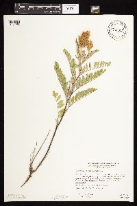 815905[1074985]Wheeler, Gerald 113881988-07-25 United States, Minnesota, Lac Qui Parle, Lac Qui Parle State Park. Lac Qui Parle Co.; Ca. 15 mi. E of Madsion; Lac Qui Parle State Park, NE of Rte. 33. Along the shore of Lac Qui Parle L Lac Qui Parle Co.; Ca. 15 mi. E of Madsion; Lac Qui Parle State Park, NE of Rte. 33. Along the shore of Lac Qui Parle Lake (SW side). N1/2 E1/2 Sec. 15, T118N, R42W (Lac Qui Parle Twp.). 118N 42W 15, 45.0151565 -95.8888708 |
MIN:Plants | 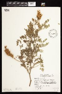 815952[1074874]Wheeler, Gerald 121261988-09-10 United States, Minnesota, Traverse, Foley Wildlife Management Area. Traverse Co.; Ca. 11 mi. E of Browns Valley; wildlife management area N of Rte. 2. On W-facing slope overlooking a small lake (E side). T 125N R 47W Sec. 29. 125N 47W 29, 45.6075142 -96.6043801 |
MIN:Plants | 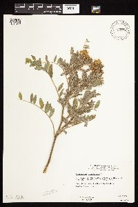 816079[1074900]Wheeler, Gerald 114331988-07-26 United States, Minnesota, Big Stone, Barry Lake Wildlife Management Area. Big Stone Co.; Ca. 1 mi. NW of Barry; ca. 0.7 mi. E of Rte. 57. On W bank of Barry Lake. W1/2 SE1/4 NE1/4 Sec. 8, T124N, R47W (Toqua Twp.). 124N 47W 8, 45.5656911 -96.586118 |
MIN:Plants | 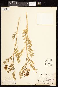 822002[1122596]Sandberg, John s.n.1886-06-00 United States, Minnesota, Goodhue, [no further data];;;;, 44.404993 -92.677429 |
MIN:Plants |  829585[1074726]Boe, J. 920718101992-07-18 United States, Minnesota, Roseau, NW Roseau County; SE1/4 SE1/4 of section;;163N;44W;30, 48.9152046 -96.3938581 |
MIN:Plants |  831642[1074913]Harris, Fred 920601992-07-13 United States, Minnesota, Red Lake, Red Lake Co. Marcoux WMA; NW1/4 Sec.19 T150N R43W;Marcoux Wildlife Management Area;150N;43W;19, 47.7960421 -96.2129679 |
MIN:Plants |  834099[1074911]Smith, Welby 197401991-07-19 United States, Minnesota, Todd, Staples Wildlife Management Area. Todd County...Staples State Wildlife Management Area, about 4 mi S of Staples (town); T133N R33W SW1/4 of NE1/4 of Sec. 36. 133N 33W 36, 46.2936096 -94.7861099 |
MIN:Plants |  838287[1074914]Smith, Welby 177171990-08-03 United States, Minnesota, Waseca, Goose Lake County Park. Waseca County ... In Goose Lake County Park, at the southeast end of Goose Lake, about 2 mi east of Waseca ... T107N R22W NW1/4 of SW1/4 of Sec 14.. 107N 22W 14, 44.0705566 -93.4436111 |
MIN:Plants |  838388[1075018]Smith, Welby 178971990-08-08 United States, Minnesota, Pennington, Pennington County ... At the SE end of the town of St. Hilaire; Red Lake River ... T152N R43W SE1/4 of SE1/4 of Sec 6;;152N;43W;6, 48.0077782 -96.2050018 |
MIN:Plants |  840530[1074984]Smith, Welby 136321987-07-30 United States, Minnesota, Washington, Grey Cloud Dunes Scientific Natural Area. Washington County...About 2 miles south of St. Paul Park; SW-facing terrace of the Mississippi River; SW1/4 SW1/4 sec.29, T 27N R 21W. 027N 21W 29, 44.7933333 -92.9625 |
MIN:Plants |  459237[1075135]Puchalski, L. 2221993-06-23 United States, Minnesota, Polk, Polk Co.; T150N R40W NW1/4 of SW1/4 of Sed 36;;150N;40W;36, 47.768721 -95.7191092 |
MIN:Plants |  459665[1075131]Abbott, Robinson s.n.1962-05-22 United States, Minnesota, Stevens, Stevens County...3 mi. W. Cyrus, Tr. 28 along RR. track.;;125N;41W;00, 45.609495 -95.825207 |
MIN:Plants |  477907[1075130]Johnson, Russell 111946-04-25 United States, Minnesota, Dakota, Dakota Co.; 2 miles southeast of Minneapolis, half mile south of Mendota bridge.;;028N;23W;, 44.877113 -93.175993 |
MIN:Plants |  727562[1075129]Schmidt, D. 281979-06-06 United States, Minnesota, Polk, Pembina Trail Preserve Scientific Natural Area. Polk County...Pembina Trail Preserve: 6 1/2 mi. E of Harold, all sec. 36, frac. sec. 25, 30, 31, T149N, R45W frac. sec. 1, 2, T148N, R45W.., 47.6660064 -96.3343338 |
MIN:Plants |  774513[1075134]Sandberg, John s.n.1886-05-00 United States, Minnesota, Goodhue, Red Wing;;113N;14W;, 44.592792 -92.586673 |
MIN:Plants |  829654[1075057]Nation, R.; Dunevitz, H. 10251993-06-09 United States, Minnesota, Olmsted, Olmsted Co. Chester Woods County Park, 1 1/4 mi S of Chester, 1 mi E of Co.Rd.19; T106N R13W NE1/4 of NE1/4 of Sec 13;Chester Woods County Park;106N;13W;13, 43.9849528 -92.3287291 |
MIN:Plants |  840458[1075133]Smith, Welby 126531987-05-08 United States, Minnesota, Washington, Washington County ... About 5 mi northeast of Hastings ... SE1/4 NE1/4 sec.29, T27N R20W;Lost Valley Prairie Scientific Natural Area;027N;20W;29, 44.8002777 -92.8194427 |
MIN:Plants |  463648[1075132]Lee, Michael MDL16451997-05-26 United States, Minnesota, Wabasha, Dorer Memorial Hardwood State Forest. Wabasha Co.; Along the Zumbro River at Rattlesnake Point, 1/4 mile north of Olmsted County line; southwest-facing slope Wabasha Co.; Along the Zumbro River at Rattlesnake Point, 1/4 mile north of Olmsted County line; southwest-facing slope overlooking Lake Zumbro; T109N R14W NW1/4 of SW1/4 of SE1/4 Sec. 34. 109N 14W 34, 44.2018738 -92.4810552 |
MIN:Plants |  134179[1075213]Sheldon, Edmund S13811891-08-00 United States, Minnesota, Lincoln, Lake Benton;;109N;45W;, 44.24108 -96.26172 |
MIN:Plants |  134531[1075070]Butters, F.; et al. 37931919-05-11 United States, Minnesota, Goodhue, 3 mi below Red Wing;;;;, 44.498334 -92.54256 |
MIN:Plants | 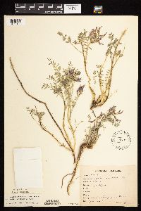 134532[1075122]Rosendahl, C. 24391910-04-13 United States, Minnesota, Ft. Snelling Reservation [old regional park spanning junction of Minnesota and Mississippi rivers];;028N;23W;, 44.891664 -93.18101 |
MIN:Plants | 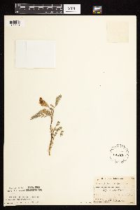 134533[1075221]Manning, Sara s.n.1890-05-00 United States, Minnesota, Wabasha, Near Lake City;;111N;12W;, 44.4081001 -92.2524539 |
MIN:Plants | 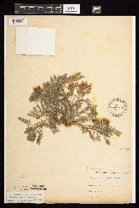 134534[1075075]Anonymous s.n.1885-05-17 United States, Minnesota, Chippewa, Montevideo;;117N;40W;, 44.953148 -95.715397 |
MIN:Plants | 134535[]Moyer, Lycurgus s.n1894-06-00 United States, Minnesota, Chippewa, Montevideo, Chippewa Co.;;117N;40W;, 44.953148 -95.715397 |
Google Map
Google Maps is a web mapping service provided by Google that features a map that users can pan (by dragging the mouse) and zoom (by using the mouse wheel). Collection points are displayed as colored markers that when clicked on, displays the full information for that collection. When multiple species are queried (separated by semi-colons), different colored markers denote each individual species.