University of Minnesota
http://www.umn.edu/
612-625-5000
http://www.umn.edu/
612-625-5000
Minnesota Biodiversity Atlas
Bell Museum
Dataset: MIN-Plants
Taxa: Eleocharis
Search Criteria: excluding cultivated/captive occurrences
Bell Museum plants | |
 MIN:Plants | 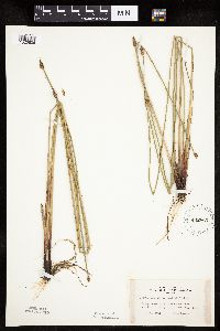 Eleocharis palustris (L.) Roemer & Schultes 442863[1020606]Lakela, Olga 134951951-07-20 United States, Minnesota, Saint Louis, Big Sturgeon Lake, N of Hibbing.;George Washington State Forest;N;;, 47.68065 -93.04596 |
MIN:Plants | 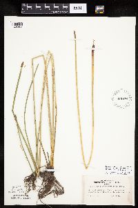 Eleocharis palustris (L.) Roemer & Schultes 442878[1020605]Lakela, Olga 133031951-07-17 United States, Minnesota, Saint Louis, Ash River, 2 mi. down stream from the Frontier Lodge, St. Louis Co.;Kabetogama State Forest;068N;19W;00, 48.368061 -92.774053 |
MIN:Plants |  Eleocharis palustris (L.) Roemer & Schultes 442946[1020604]Lakela, Olga 125911951-06-23 United States, Minnesota, Saint Louis, White Iron Lake at Burley's Resort, St. Louis Co.;Superior National Forest;062N;12W;, 47.872633 -91.793623 |
MIN:Plants |  Eleocharis palustris (L.) Roemer & Schultes 445285[1102708]Myhre, K. 56281995-06-19 United States, Minnesota, Crow Wing, Crow Wing Co.; Located 4 miles southeast of the town of Brainerd. Plants occur along the south bays of Perch Lake; T 133 Crow Wing Co.; Located 4 miles southeast of the town of Brainerd. Plants occur along the south bays of Perch Lake; T 133N R 29W SW1/4 of NE1/4 of Sec 13. 133N 29W 13, 46.332469 -94.275724 |
MIN:Plants | 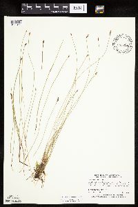 Eleocharis erythropoda Steudel 445292[1020154]Myhre, K. 57881995-07-01 United States, Minnesota, Crow Wing, Crow Wing County...Located 4.5 mi. northeast of the town of Pequot Lakes. Plants occur along the wst bays of Upper Whitefish Lake...T 137N R 29W SE1/4 of NE1/4 of Sec 13. 137N 29W 13, 46.682255 -94.293169 |
MIN:Plants | 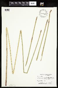 Eleocharis palustris (L.) Roemer & Schultes 445295[1020719]Myhre, K. 61811995-08-27 United States, Minnesota, Aitkin, Aitkin Co.; Located 5 miles southeast of the town of Aitkin. Plants occur along the north bays of Sisabagamah Lake; T 47 Aitkin Co.; Located 5 miles southeast of the town of Aitkin. Plants occur along the north bays of Sisabagamah Lake; T 47N R 26W NW1/4 of SE1/4 of Sec 34. 047N 26W 34, 46.512316 -93.61133 |
MIN:Plants |  Eleocharis erythropoda Steudel 445296[1020087]Myhre, K. 58311995-07-05 United States, Minnesota, Crow Wing, Crow Wing County ... Located 11 miles west of the town of Garrison. Plants occur along the southeast shore of South Long Lake ... T 44N R 30W NW1/4 of SE1/4 of Sec 23. 044N 30W 23, 46.279214 -94.09314 |
MIN:Plants |  Eleocharis palustris (L.) Roemer & Schultes 445298[1020618]Myhre, K. 56181995-06-19 United States, Minnesota, Crow Wing, Crow Wing County...Located 4 miles southeast of the town of Brainerd. Plants occur along the south bays of Perch Lake...T 133N R 29W SW1/4 of NE1/4 of Sec 13. 133N 29W 13, 46.332469 -94.275724 |
MIN:Plants |  Eleocharis palustris (L.) Roemer & Schultes 445299[1020746]Myhre, K. 56171995-06-19 United States, Minnesota, Crow Wing, Crow Wing Co.; Located 4 miles southeast of the town of Brainerd. Plants occur along the south bays of Perch Lake; T 133 Crow Wing Co.; Located 4 miles southeast of the town of Brainerd. Plants occur along the south bays of Perch Lake; T 133N R 29W SW1/4 of NE1/4 of Sec 13. 133N 29W 13, 46.332469 -94.275724 |
MIN:Plants |  Eleocharis palustris (L.) Roemer & Schultes 445300[1102727]Myhre, K. 55251995-06-12 United States, Minnesota, Aitkin, Aitkin Co.; Located one mile northeast of greater downtown Glen; northeast shore Clear Lake; T 46N R 25W SW1/4 of SE1/4 Aitkin Co.; Located one mile northeast of greater downtown Glen; northeast shore Clear Lake; T 46N R 25W SW1/4 of SE1/4 of Sec 28. 046N 25W 28, 46.439945 -93.504805 |
MIN:Plants |  Eleocharis palustris (L.) Roemer & Schultes 445309[1020588]Myhre, K. 58181995-07-04 United States, Minnesota, Aitkin, Aitkin Co.; Located one mile southeast of the town of Glen; Sugar Lake; T 45N R 25W SE1/4 of NW1/4 of Sec 2;;045N;25W;2, 46.412527 -93.462325 |
MIN:Plants |  Eleocharis palustris (L.) Roemer & Schultes 445915[1020728]Moore, John; Huff, N. 180071945-07-26 United States, Minnesota, Morrison, Along the shore of Twin Lakes, 5 mi. W of Little Falls.;;129N;30W;, 45.97698 -94.451652 |
MIN:Plants |  Eleocharis erythropoda Steudel 446342[1020142]Moore, John; Huff, N. 187851946-07-31 United States, Minnesota, Benton, Benton County...1/2 mi. east of East St. Cloud, adjacent to Highway No. 23;;036N;30W;, 45.603343 -94.07039 |
MIN:Plants |  Eleocharis erythropoda Steudel 453364[1020155]Myhre, K. 51731994-07-06 United States, Minnesota, Itasca, Itasca County...Located along the southwest shore of Ball Club Lake...T 144N R 26W NE1/4 of NW1/4 of sec 1;Chippewa National Forest / Leech Lake Indian Reservation;144N;26W;01, 47.31779 -93.911914 |
MIN:Plants | 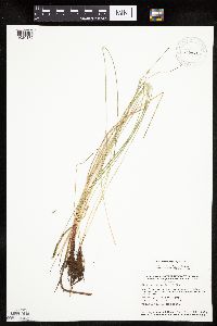 Eleocharis erythropoda Steudel 453468[1020132]Smith, Welby 132401987-06-29 United States, Minnesota, Washington, Washington County...Corries Swamp; large wetland about 8 miles west of Marine on St. Croix; NW1/4 SE1/4 section 26, T 32N R 21W. 032N 21W 26, 45.2161111 -92.9244444 |
MIN:Plants | 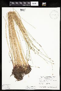 Eleocharis erythropoda Steudel 458857[1020153]Smith, Welby 154541989-06-25 United States, Minnesota, Freeborn, Myre Big Island State Park. Freeborn County...Helmer Myre State Park, about 2 miles southeast of Albert Lea. On 'Big Island' in Albert tc. Lea Lake...SW1/4 NW1/4 sec.19, T 102N R 20W. 102N 20W 19, 43.625 -93.2874985 |
MIN:Plants | 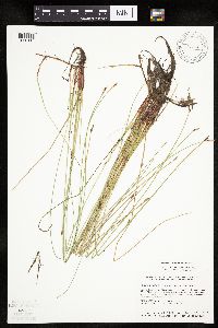 Eleocharis erythropoda Steudel 459118[1020116]Smith, Welby 131891987-06-27 United States, Minnesota, Pipestone, Altona Wildlife Management Area. Pipestone County ... Altona State Wildlife Management Area, about 1.5 miles SE of Verdi ... Flandreau Creek ... NW1/4 NW1/4 sec.1, T108N R46W. 108N 46W 1, 44.1966667 -96.3249969 |
MIN:Plants | 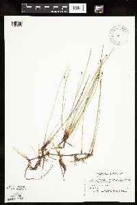 Eleocharis erythropoda Steudel 460117[1020079]Myhre, K. 30841992-01-14 United States, Minnesota, Cass, Cass County ... Located one mile northwest of Lake Ada ... T 139N R 29W NE1/4 of NW1/4 of Sec 21;;139N;29W;21, 46.841876 -94.352798 |
MIN:Plants |  Eleocharis palustris (L.) Roemer & Schultes 460224[1020638]Mensing, D. 95-601995-09-08 United States, Minnesota, Chisago, Chisago Co, T36N R20W SE1/4 of the NW1/4 of S30; floodplain of Goose Creek;;036N;20W;30, 45.578689 -92.891116 |
MIN:Plants |  Eleocharis palustris (L.) Roemer & Schultes 460225[1020595]Mensing, D. 95-8051995-08-23 United States, Minnesota, Carlton, Carlton Co. T49N R21W SW1/4 of the SE1/4 of S8; floodplain of the Little Tamarack River;;049N;21W;8, 46.745401 -93.031191 |
MIN:Plants |  Eleocharis erythropoda Steudel 460734[1020077]Myhre, K. 44461993-08-10 United States, Minnesota, Pine, Saint Croix State Forest. Pine County ... Located just east of the public access to the St. Croix River, one half mile north of Danbury ... T 41N R 16W SE1/4 of SE1/4 of Sec 21. 041N 16W 21, 46.020737 -92.372456 |
MIN:Plants |  Eleocharis palustris (L.) Roemer & Schultes 460750[1020637]Myhre, K. 44101993-08-08 United States, Minnesota, Pine, Pine Co.; Located 6 miles northeast of the town of Bruno; T 44N R 17W SW1/4 of SE1/4 of Sec 7;Nemadji State Forest;044N;17W;7, 46.309418 -92.541551 |
MIN:Plants |  Eleocharis palustris (L.) Roemer & Schultes 463101[1020759]Lakela, Olga 143511952-06-21 United States, Minnesota, Saint Louis, Bay, Sand Point Lake s of the Narrows;Voyageurs National Park;N;;, 48.382064 -92.492038 |
MIN:Plants |  Eleocharis palustris (L.) Roemer & Schultes 463132[1020607]Lakela, Olga 143011952-06-19 United States, Minnesota, Saint Louis, Namakan Lake, 3 mi. from the Narrows.;Voyageurs National Park;N;;, 48.428244 -92.527018 |
MIN:Plants |  Eleocharis palustris (L.) Roemer & Schultes 463257[1020601]Lakela, Olga 156381952-08-23 United States, Minnesota, Saint Louis, Crooked Lake, at Curtain Falls;Boundary Waters Canoe Area Wilderness / Superior National Forest;066N;12W;, 48.186787 -91.869968 |
MIN:Plants |  Eleocharis palustris (L.) Roemer & Schultes 463498[1020608]Lakela, Olga 147191952-07-10 United States, Minnesota, Saint Louis, Cranberry Bay, Rainy Lake.;Voyageurs National Park;071N;21W;, 48.606257 -93.024038 |
MIN:Plants | 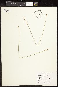 Eleocharis palustris (L.) Roemer & Schultes 464329[1102729]Smith, Michael 8521998-08-05 United States, Minnesota, Saint Louis, Voyageurs National Park. St Louis Co.; Daley Bay. 48 25'32" N 92 56'36" W;Voyageurs National Park;069N;20W;, 48.455602 -92.896321 |
MIN:Plants | 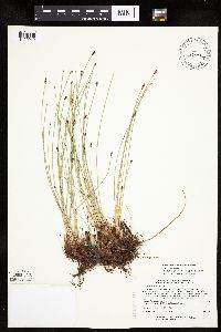 Eleocharis compressa var. compressa Sullivant 463643[1020012]Lee, Michael MDL16911997-06-05 United States, Minnesota, Stearns, Stearns County...'Orion Miller Prairie' along the old Great Northern Railroad grade (Glacial Lakes State Trail) 1-1/2 miles north of Paynesville...prairie remnant north of the railroad grade...T122N R32W SW1/4 of NE1/4 Sec. 4. 122N 32W 4, 45.405383 -94.712081 |
MIN:Plants | 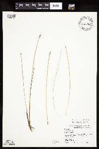 Eleocharis palustris (L.) Roemer & Schultes 466375[1020757]Smith, Michael 7961996-06-24 United States, Minnesota, Koochiching, East Rat Root River Peatland Scientific Natural Area. Voyageurs National Park. Koochiching County...west entrance to Rat Root Peatland SNA [not in national park]; Rat Root Peatland.. 069N 22W , 48.481945 -93.1991653 |
MIN:Plants | 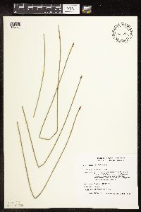 Eleocharis palustris (L.) Roemer & Schultes 466790[1102730]Smith, Michael 2771996-08-26 United States, Minnesota, Saint Louis, Voyageurs National Park. St Louis Co.; Plot Name: Voya 24 DNR # 5782; 48 33'42" 93 04'58";Voyageurs National Park;070N;21W;, 48.543303 -93.025051 |
MIN:Plants | 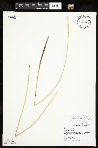 Eleocharis palustris (L.) Roemer & Schultes 466872[1020747]Smith, Michael 8741998-08-25 United States, Minnesota, Saint Louis, Voyageurs National Park. St Louis County...End of Johnson Bay.;Voyageurs National Park;069N;19W;, 48.4741669 -92.7477798 |
MIN:Plants | 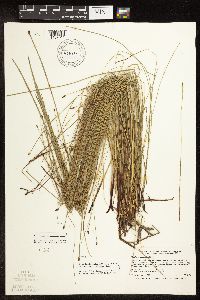 Eleocharis erythropoda Steudel 473798[1102611]Smith, Welby 297391992-07-13 United States, Minnesota, Wadena, Between Trunk Highway 10 and the Burlington Northern railroad tracks, about one mile southeast of Verndale. NW1/4 of SW1/4 of section;;134N;34W;28, 46.3869444 -94.9852778 |
MIN:Plants | 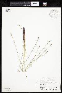 Eleocharis palustris (L.) Roemer & Schultes 474800[1020593]Myhre, K. 39211993-06-24 United States, Minnesota, Pine, Pine Co.; Located along the shores of Stevens Lake; T 41N R 17W NW1/4 of SW1/4 of Sec 2;Saint Croix State Forest;041N;17W;2, 46.062886 -92.45679 |
MIN:Plants | 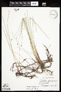 Eleocharis palustris (L.) Roemer & Schultes 475930[1020615]Smith, Welby 211751992-07-31 United States, Minnesota, Le Sueur, Le Sueur County...At the south end of Fish Lake, about 2 miles north of Elysian...T 109N R 24W SE1/4 of SE1/4 of Sec 23;;109N;24W;23, 44.2272224 -93.6699982 |
MIN:Plants | 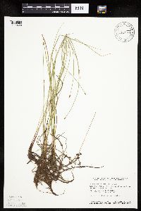 Eleocharis palustris (L.) Roemer & Schultes 476429[1020689]Smith, Welby 129351987-06-09 United States, Minnesota, Washington, Belwin Outdoor Education Laboratory. Washington County...Belwin Outdoor Education Center; about 1 mi north of Afton. On the floodplain of the St. Croix River. SW1/4 NE1/4 section 15, T 28N R 20W [lat/long incorrect]. 028N 20W 15, 44.912609 -92.791861 |
MIN:Plants | 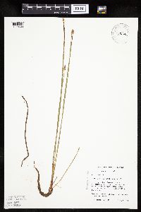 Eleocharis palustris (L.) Roemer & Schultes 485073[1020598]Mensing, D. 95-6031995-08-15 United States, Minnesota, Carlton, Carlton Co.; T49N R17W NW1/4 of the NE1/4 of S29; Otter Creek;Fond du Lac Indian Reservation;049N;17W;29, 46.699921 -92.522664 |
MIN:Plants | 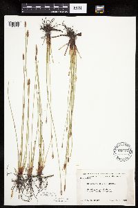 Eleocharis palustris (L.) Roemer & Schultes 488452[1020750]Moore, John 200751949-06-02 United States, Minnesota, Clay, 1 mi. S of Rollag.;;N;;, 46.725481 -96.238118 |
MIN:Plants | 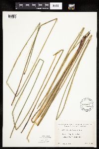 Eleocharis palustris (L.) Roemer & Schultes 491803[1020613]Lakela, Olga 1657891953-08-06 United States, Minnesota, Saint Louis, Bay, Lac La Croix, s of Lac La Croix Lodge;Boundary Waters Canoe Area Wilderness / Superior National Forest;N;;, 48.335852 -92.124151 |
MIN:Plants | 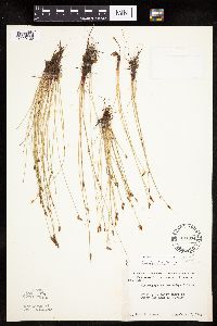 Eleocharis erythropoda Steudel 497374[1020130]Moore, John 202311949-06-22 United States, Minnesota, Beltrami, Beltrami County...Upper Red Lake at Waskish.;Red Lake State Forest;154N;30W;, 48.149321 -94.488234 |
MIN:Plants | 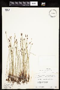 Eleocharis macrostachya Britton 497477[1020317]Moore, John 202101949-06-21 United States, Minnesota, Lake of the Woods, Lake of the Woods County ... Growing at Long Point on Lake of the Woods.;;164N;34W;, 49.017853 -95.025935 |
MIN:Plants | 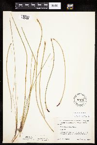 Eleocharis palustris (L.) Roemer & Schultes 500656[1020658]Harris, S. 3401953-06-30 United States, Minnesota, Marshall, Marshall County...Plot 21. Growing in Mud Lake Pool (T.R.C.) Mud Lake National Wildlife Refuge.;Agassiz National Wildlife Refuge;;;, 48.345231 -95.945894 |
MIN:Plants | 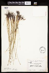 Eleocharis palustris (L.) Roemer & Schultes 501160[1020647]Moore, John 2031949-06-29 United States, Minnesota, Roseau, Lake of the Woods at Warroad.;;N;;, 48.905266 -95.314404 |
MIN:Plants | 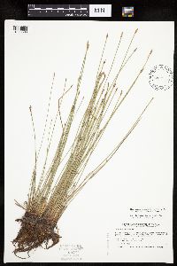 Eleocharis palustris (L.) Roemer & Schultes 504934[1020596]Smith, Welby 179311990-08-08 United States, Minnesota, Pennington, Pennington County...At the SE end of the town of St. Hilaire...Red Lake River...T152N R43W SE1/4 of SE1/4 of Sec 6;;152N;43W;06, 48.0077782 -96.2050018 |
MIN:Plants | 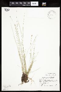 Eleocharis erythropoda Steudel 504955[1020160]Smith, Welby 186671991-06-05 United States, Minnesota, Redwood, Redwood County...Minnesota Valley, about 3.5 mi N of Belview...T114N R37W NE1/4 of SE1/4 of Sec 19;;114N;37W;19, 44.6630554 -95.461113 |
MIN:Plants |  Eleocharis palustris (L.) Roemer & Schultes 505295[1020756]Smith, Michael 4431997-08-02 United States, Minnesota, Koochiching, Voyageurs National Park. Koochiching Co.; Plot Name: Voya 61, DNR #7250; Rat Root Peatland;Voyageurs National Park;069N;22W;, 48.4883347 -93.1238861 |
MIN:Plants | 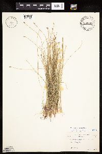 Eleocharis erythropoda Steudel 505691[1020217]Abbott, Robinson 1961-08-04 United States, Minnesota, Stevens, Stevens County...edge of Long Lake;;;;, 45.5893 -95.79276 |
MIN:Plants |  Eleocharis NULL 507245[1102507]Moore, John 206711950-06-20 United States, Minnesota, Martin, Martin County...south end of Hall Lake south of Fairmont.;;102N;30W;, 43.630246 -94.430321 |
MIN:Plants | 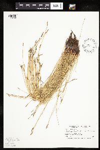 Eleocharis erythropoda Steudel 508319[1020108]Smith, Welby 170921990-06-27 United States, Minnesota, Martin, Martin County ... At the public access on the E shore of Pierce Lake, about 3 mi SW of Fairmont ... T 102N R 31W NW1/4 of NW1/4 of Sec 34. 102N 31W 34, 43.6011124 -94.5516663 |
MIN:Plants | 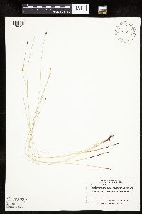 Eleocharis erythropoda Steudel 508690[1020078]Lee, Michael MDL10151995-06-22 United States, Minnesota, Winona, Winona County ... along Money Creek 5-1/2 mi northeast of Rushford ... T105N R7W NESW 28;Dorer Memorial Hardwood State Forest;105N;07W;28, 43.868427 -91.670114 |
MIN:Plants | 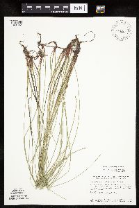 Eleocharis erythropoda Steudel 508726[1020195]Smith, Welby 144191988-07-01 United States, Minnesota, Nobles, Nobles County...About 4 mi west of Worthington...right-of-way of the Chicago and Northwestern Railroad line...SW1/4 sec.25, T102N R41W. 102N 41W 25, 43.6061096 -93.702774 |
MIN:Plants | 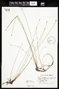 Eleocharis palustris (L.) Roemer & Schultes 514297[1020636]Smith, Welby 190611991-06-30 United States, Minnesota, Aitkin, Aitkin Co.; about 3 miles NW of Glen; a small un-named lake; T46N R26W NE1/4 of SW1/4 of Sec 24;;046N;26W;24, 46.4494438 -93.569725 |
MIN:Plants | 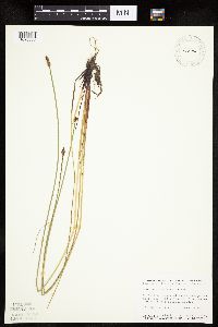 Eleocharis palustris (L.) Roemer & Schultes 514674[1020688]Smith, Welby 156121989-07-00 United States, Minnesota, Kittson, Caribou Wildlife Management Area. Kittson Co.; In Caribou State Wildlife Management Area, about 13 miles NE of Lancaster. NE1/4 SW1/4 section 1, T 163N R Kittson Co.; In Caribou State Wildlife Management Area, about 13 miles NE of Lancaster. NE1/4 SW1/4 section 1, T 163N R 46W.. 163N 46W 1, 48.969826 -96.547093 |
MIN:Plants |  Eleocharis palustris (L.) Roemer & Schultes 515630[1020592]Schik, K. 96-901996-06-18 United States, Minnesota, Kittson, Kittson Co, T162N R45W NE1/4 of the NE1/4 of S22; Beaches Wildlife Management Area.;Beaches Lake Wildlife Management Area;162N;45W;22, 48.84082 -96.45896 |
MIN:Plants |  Eleocharis palustris (L.) Roemer & Schultes 515661[1020671]Myhre, K. 26431992-07-09 United States, Minnesota, Cass, Cass Co.; located on the southeast shore of Moccasin Lake; T 141N R 29W NW1/4 of NW1/4 of Sec 33;Chippewa National Forest;141N;29W;33, 46.986407 -94.355731 |
MIN:Plants |  Eleocharis palustris (L.) Roemer & Schultes 515662[1020670]Myhre, K. 29441992-08-04 United States, Minnesota, Cass, Chippewa National Forest / Leech Lake Indian Reservation. Cass Co.; located just west of the Mississippi River. Plants growing in a small oxbow of the river; T 145N R 26W SW1/4 o Cass Co.; located just west of the Mississippi River. Plants growing in a small oxbow of the river; T 145N R 26W SW1/4 of SW1/4 of Sec 34. 145N 26W 34, 47.332254 -93.956198 |
MIN:Plants |  Eleocharis palustris (L.) Roemer & Schultes 515777[1020589]Schik, K. 96-1011996-06-25 United States, Minnesota, Wilkin, Wilkin Co.; T133N R47W SW1/4 of the SE1/4 of S33; Golf course 50 m from the edge of the Red River.;;133N;47W;33, 46.290504 -96.59596 |
MIN:Plants |  Eleocharis palustris (L.) Roemer & Schultes 519235[1020591]Lobien, D. s.n.1993-07-07 United States, Minnesota, Washington, About one mile and a half east of White Bear Lake in Washington Co.; NW 1/4 SEC.26, NE1/4 SEC.27 T30N, R21W;;030N;21W;, 45.079652 -92.9239 |
MIN:Plants |  Eleocharis palustris (L.) Roemer & Schultes 520157[1020590]Myhre, K. 32621992-09-02 United States, Minnesota, Cass, Cass County...north shore of Camp Lake...northwest bay of the lake...T140N R27W SE1/4 of NW1/4 of Sec 30;;140N;27W;30, 46.912765 -94.144072 |
MIN:Plants |  Eleocharis erythropoda Steudel 520159[1020157]Myhre, K. 30911992-08-17 United States, Minnesota, Cass, Cass County...Located 1 mile NW of Sylvan Lake...edge of the Crow Wing River...T133N R30W SW1/4 of NE1/4 of Sec 24;;133N;30W;24, 46.316245 -94.404584 |
MIN:Plants |  Eleocharis palustris (L.) Roemer & Schultes 520161[1102731]Myhre, K. 28951992-07-31 United States, Minnesota, Cass, Cass Co.; located 1/4 mile NE of Ponto Lake; T139N R29W NE1/4 of SE1/4 of Sec 3;;139N;29W;3, 46.884878 -94.331697 |
MIN:Plants |  Eleocharis palustris (L.) Roemer & Schultes 525753[1020610]Lakela, Olga 190121955-08-03 United States, Minnesota, Saint Louis, Johnson's Lake, S of Namakan Lake.;Superior National Forest;018N;68W;, 48.368437 -92.650228 |
MIN:Plants | 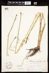 Eleocharis palustris (L.) Roemer & Schultes 526877[1020609]Lakela, Olga 181731954-08-13 United States, Minnesota, Saint Louis, Saturday Bay of Crooked Lake.;Boundary Waters Canoe Area Wilderness / Superior National Forest;066N;12W;, 48.186787 -91.869968 |
MIN:Plants | 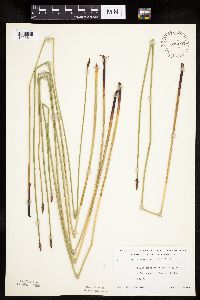 Eleocharis palustris (L.) Roemer & Schultes 532603[1020611]Lakela, Olga 203731956-07-10 United States, Minnesota, Saint Louis, W side of Island Lake, S of Hibbing, Hwy. 73.;;055N;21W;, 47.239418 -93.002014 |
MIN:Plants | 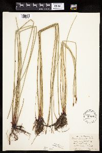 Eleocharis palustris (L.) Roemer & Schultes 536185[1020630]Anderson, W. s.n.1947-08-13 United States, Minnesota, Becker, De Soto Lake, Itasca State Park;Itasca State Park;142N;36W;, 47.145259 -95.222785 |
MIN:Plants | 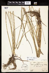 Eleocharis palustris (L.) Roemer & Schultes 538820[1020731]Butters, F.; Abbe, E. 9361944-08-04 United States, Minnesota, Cook, Cook County...Sea Gull River. Twp. 66N R. 4W;Boundary Waters Canoe Area Wilderness / Superior National Forest;066N;04W;, 48.187851 -90.858177 |
MIN:Plants |  Eleocharis palustris (L.) Roemer & Schultes 541510[1020729]Scharf, J. s.n.1956-07-11 United States, Minnesota, Murray, Murray County...Chandler Marsh. State-owned marsh 1 mile n.e. of Chandler.;Chandler Marsh Wildlife Management Area;106N;43W;, 43.979058 -96.003934 |
MIN:Plants |  Eleocharis palustris (L.) Roemer & Schultes 543397[1102743]Lakela, Olga 219731957-08-14 United States, Minnesota, Lake, Greenwood Lake, N of Two Harbors, Hwy. 2.;Superior National Forest;N;;, 47.518701 -91.63254 |
MIN:Plants |  Eleocharis palustris (L.) Roemer & Schultes 553615[1102732]Bernardini, J.; Moore, John 1311958-09-18 United States, Minnesota, Blue Earth, South-west quarter of section 26 of Medo Township, Blue Earth County;;106N;25W;26, 43.956867 -93.798108 |
MIN:Plants |  Eleocharis palustris (L.) Roemer & Schultes 553617[1020648]Haig, Vincent 1131958-07-19 United States, Minnesota, Becker, Near Desoto Cabin and Lind Saddle Trail, Hernando Desoto Lake, Itasca State Park;Itasca State Park;142N;36W;, 47.108802 -95.233537 |
MIN:Plants |  Eleocharis palustris (L.) Roemer & Schultes 560888[1020705]Ownbey, Gerald; et al. 21921955-06-19 United States, Minnesota, Clearwater, Clearwater County...Itasca State Park. Lake Itasca. S of Schoolcraft Island.;Itasca State Park;143N;36W;, 47.19557 -95.233216 |
MIN:Plants | 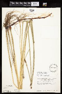 Eleocharis palustris (L.) Roemer & Schultes 561089[1020644]Ownbey, Gerald 22191955-06-28 United States, Minnesota, Becker, Becker County...East shore of De Soto Lake;Itasca State Park;142N;36W;, 47.108802 -95.233537 |
MIN:Plants | 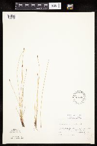 Eleocharis erythropoda Steudel 565062[1020139]Cotter, Shirley 4301951-08-28 United States, Minnesota, Washington, swamp north of Clear Lake, 2 mi. west of Forest Lake, in Anoka County [Clear Lake is in Washington Co.];;032N;21W;, 45.253532 -92.958232 |
MIN:Plants | 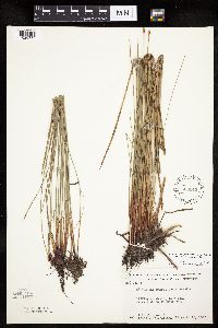 Eleocharis palustris (L.) Roemer & Schultes 566343[1020735]Moore, John; Bernardini, J. 243041958-09-18 United States, Minnesota, Blue Earth, Blue Earth County...S. W. 1/4 Sect. 26 Medo Twp.;;106N;25W;26, 43.956867 -93.798108 |
MIN:Plants | 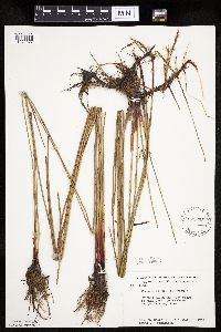 Eleocharis palustris (L.) Roemer & Schultes 572695[1020677]Moore, John; Bernardini, J. 258651961-10-05 United States, Minnesota, Anoka, Along the W shore of Fish Lake, Cedar Creek Natural History Area.;Cedar Creek National History Area;034N;23W;, 45.428063 -93.203997 |
MIN:Plants |  Eleocharis palustris (L.) Roemer & Schultes 574885[1020730]Moore, John 246721959-07-28 United States, Minnesota, Kittson, Kittson County...1-1/2 mi east of Noyes;;164N;50W;, 48.988533 -97.128144 |
MIN:Plants |  Eleocharis palustris (L.) Roemer & Schultes 576836[1020695]Isaak, Daniel s.n.1959-09-19 United States, Minnesota, Isanti, Isanti County...Horseshoe Lake, Sections 2 and 11, Township 34 North and Range 22 West;;034N;22W;, 45.427323 -93.081077 |
MIN:Plants |  Eleocharis palustris (L.) Roemer & Schultes 594493[1020620]Thorne, Robert 311191962-07-16 United States, Minnesota, Hubbard, Itasca State Park. Hubbard County...SE margin, small lake W of Hwy 71 ca. 1/2 mi S of junction with Hwy 92 and Park Entrance, NW 1/4 Sec.26, T143N, R35W (Lake Alice Twp.). 143N 35W , 47.195787 -95.107789 |
MIN:Plants |  Eleocharis palustris (L.) Roemer & Schultes 598405[1020597]Myhre, K. 56461995-06-20 United States, Minnesota, Aitkin, Aitkin Co.; Located one half mile southwest of Elm Island Lake. Plants occur along the west bays of Lone Lake; T 46N R 2 Aitkin Co.; Located one half mile southwest of Elm Island Lake. Plants occur along the west bays of Lone Lake; T 46N R 26W NW1/4 of SE1/4 of Sec 30. 046N 26W 30, 46.43923 -93.675342 |
MIN:Plants | 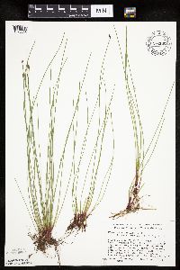 Eleocharis palustris (L.) Roemer & Schultes 676332[1020666]Ownbey, Gerald 52511976-08-06 United States, Minnesota, Clearwater, S end and SW corner of Mink Lake.;Itasca State Park;143N;36W;7, 47.216898 -95.286535 |
MIN:Plants | 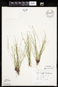 Eleocharis palustris (L.) Roemer & Schultes 681937[1020732]Clemants, Steven 5001976-08-14 United States, Minnesota, Mahnomen, Mahnomen County...Sullivan Lake, 1 mi E of town of Waubun.;White Earth Indian Reservation;143N;41W;, 47.194255 -95.869088 |
MIN:Plants | 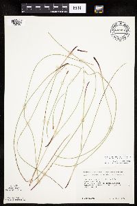 Eleocharis palustris (L.) Roemer & Schultes 682092[1020758]Kirwan, Jeff s.n.1977-07-10 United States, Minnesota, Koochiching, Koochiching County...Tom Cod Bay, Lake Kabetogama, Voyageurs National Park. Sec. 2;Voyageurs National Park;069N;22W;2, 48.494947 -93.123727 |
MIN:Plants | 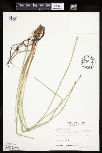 Eleocharis palustris (L.) Roemer & Schultes 687813[1020687]Wheeler, Gerald; Glaser, Paul 22591977-07-25 United States, Minnesota, Itasca, Itasca Co.; NW1/4 Sec.1 T144N R25W; approx. 12.5 mi NW of Grand Rapids; N side of White Oak Lake;Chippewa National Forest / Leech Lake Indian Reservation;144N;25W;1, 47.317045 -93.784556 |
MIN:Plants | 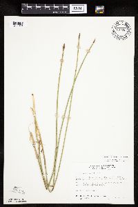 Eleocharis palustris (L.) Roemer & Schultes 687853[1020633]Wheeler, Gerald; Glaser, Paul 22991977-07-28 United States, Minnesota, Itasca, Itasca County...Coll. Site No. 153...SE1/4 NW1/4 Sec. 24 T57N R26W, approx. 11.5 miles NNW of Grand Rapids...west side of Pughole Lake.. 057N 26W 24, 47.407462 -93.588795 |
MIN:Plants | 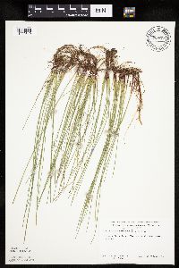 Eleocharis palustris (L.) Roemer & Schultes 689877[1020640]Ownbey, Gerald 58041977-08-15 United States, Minnesota, Clearwater, Itasca State Park. E shore of Bohall Lake.;Itasca State Park;143N;36W;, 47.19557 -95.233216 |
MIN:Plants | 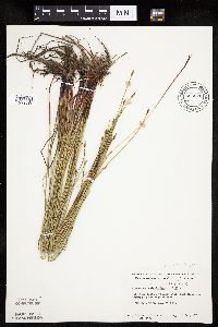 Eleocharis palustris (L.) Roemer & Schultes 695926[1020639]Clemants, Steven 14471978-07-08 United States, Minnesota, Kandiyohi, 3.1 mi. S of Sibley State Park on Hwy. 71.;Sibley State Park;121N;35W;, 45.282269 -95.070706 |
MIN:Plants | 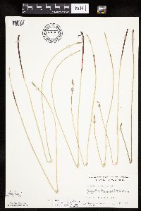 Eleocharis macrostachya Britton 695965[1020323]Clemants, Steven 14831978-07-18 United States, Minnesota, Clay, Clay County...Buffalo River State Park, 0.8 mi. east of the entrance...along railroad. T 139 N, R 46 W, NE1/4 Sect. 20;Buffalo River State Park;139N;46W;20, 46.841139 -96.515724 |
MIN:Plants |  Eleocharis palustris (L.) Roemer & Schultes 696490[1020624]Smith, Welby 8511978-07-19 United States, Minnesota, Wright, Wright County...T. 121N. R. 27W. N.E.1/4 section 28. 1/4 mi. west of state aid road 6.;;121N;27W;28, 45.266091 -94.08483 |
MIN:Plants |  Eleocharis macrostachya Britton 698370[1020321]Wheeler, Gerald; Glaser, Paul 31711978-07-05 United States, Minnesota, Beltrami, Red Lake Peatland Scientific Natural Area. pprox. 9 miles north of the Waskish Airport on Route 72, a little over 0.25 mile west of the road. Ludlow Lookout Tower Area. NW1/4 NE1/4 of section over 0.25 mile west of the road...Ludlow Lookout Tower Area.. 156N 31W 36, 48.287244 -94.564235 |
MIN:Plants |  Eleocharis palustris (L.) Roemer & Schultes 700637[1102721;1102721_2]Ownbey, Gerald 60211978-07-07 United States, Minnesota, Clearwater, Clearwater County...De Soto Lake. E side of the N end near the trail. Itasca State Park.;Itasca State Park;143N;36W;, 47.19557 -95.233216 |
MIN:Plants |  Eleocharis palustris (L.) Roemer & Schultes 700984[1020626]Dorio, J. 5341977-07-13 United States, Minnesota, Morrison, Morrison County...Ripley Esker, about 3 mi. NE of Camp Ripley junction...T 42 N, R 31 W, Sec. 19.;Ripley Esker Scientific Natural Area;042N;31W;19, 46.106283 -94.30299 |
MIN:Plants |  Eleocharis palustris (L.) Roemer & Schultes 704655[1020696]Smith, Welby 17081979-08-16 United States, Minnesota, Wabasha, Wabasha County...T109N R9W NW1/4 NW1/4 section 18. 150 m due west of county road 84...north side of small marshy pond;;109N;09W;18, 44.243599 -91.939111 |
MIN:Plants | 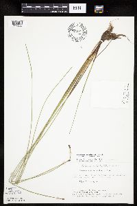 Eleocharis palustris (L.) Roemer & Schultes 722799[1020699]Lustig, K. 9281979-08-13 United States, Minnesota, Anoka, Anoka County...Boot Lake SNA: 18 mi. SE of Cambridge, sec. 17, 18, 19, 20, T 33N, R 22W;Boot Lake Scientific Natural Area;033N;22W;00, 45.340658 -93.081463 |
MIN:Plants |  Eleocharis NULL 727980[1102504]Farrell, P.; et al. 2571979-08-14 United States, Minnesota, Polk, Pembina Trail Preserve Scientific Natural Area. Polk County...Pembina Trail Preserve...6-1/2 mi. east of Harold, all sec. 36, frac. sec. 25, 30, 31, T 149N, R 45W, frac. sec. 1, 2, T 148N, R 45W. , 47.62967 -96.38702 |
MIN:Plants | 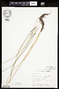 Eleocharis palustris (L.) Roemer & Schultes 729333[1020698]Converse, C. 7211980-08-13 United States, Minnesota, Pine, Pine County...St. Croix Natural Area: 21 mi E of Hinckley. NW1/4 SE1/4 NE1/4 sec.5, T40N, R17W;Saint Croix State Park;040N;17W;5, 45.980424 -92.496049 |
MIN:Plants |  Eleocharis NULL 730847[1102509]Cross-Cella, J. 1511980-06-17 United States, Minnesota, Clay, Clay County...Audubon Prairie: 16.5 mi. east-southeast of Moorhead. SE1/4 SE1/4 Section 32, T139N, R45W;Audubon Prairie, The Nature Conservancy;139N;45W;32, 46.811205 -96.398224 |
MIN:Plants | 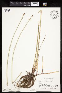 Eleocharis palustris (L.) Roemer & Schultes 744529[1020679]Converse, C. 14011982-06-30 United States, Minnesota, Pope, Moe Woods.;Moe Woods, The Nature Conservancy;123N;36W;34, 45.41981 -95.183338 |
MIN:Plants | 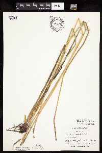 Eleocharis palustris (L.) Roemer & Schultes 744641[1020625]Converse, C. 19471982-08-07 United States, Minnesota, Douglas, Douglas County...Staffanson Prairie: T127N R40W NW1/4 NE1/4 and NE1/4 NW1/4 of sec. 18;Staffanson Prairie, The Nature Conservancy;127N;40W;18, 45.810665 -95.748005 |
MIN:Plants | 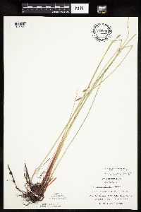 Eleocharis palustris (L.) Roemer & Schultes 744739[1020614]Converse, C. 14631982-07-06 United States, Minnesota, Otter Tail, Otter Tail County...Otter Tail Preserve: T131N, R44W, E1/2 of Sec. 17.;Ottertail Prairie Scientific Natural Area;131N;44W;17, 46.159244 -96.235363 |
MIN:Plants | 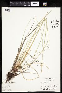 Eleocharis palustris (L.) Roemer & Schultes 744834[1020678]Converse, C. 11021982-06-11 United States, Minnesota, Chippewa, Chippewa and Swift Cos. Chippewa Prairie. SE1/4 SW1/4 Sec.12; T119N R43W;Chippewa Prairie, The Nature Conservancy;119N;43W;12, 45.130213 -95.990566 |
MIN:Plants | 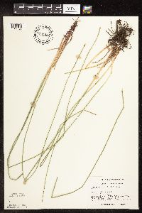 Eleocharis palustris (L.) Roemer & Schultes 744835[1102739]Converse, C. 13241982-06-27 United States, Minnesota, Chippewa, Chippewa and Swift Cos. Chippewa Prairie. NW1/4 SW1/4 Sec.12, T119N R43W;Chippewa Prairie, The Nature Conservancy;119N;43W;12, 45.130213 -95.990566 |
Google Map
Google Maps is a web mapping service provided by Google that features a map that users can pan (by dragging the mouse) and zoom (by using the mouse wheel). Collection points are displayed as colored markers that when clicked on, displays the full information for that collection. When multiple species are queried (separated by semi-colons), different colored markers denote each individual species.