University of Minnesota
http://www.umn.edu/
612-625-5000
http://www.umn.edu/
612-625-5000
Minnesota Biodiversity Atlas
Bell Museum
Dataset: MIN-Plants
Taxa: Eleocharis
Search Criteria: excluding cultivated/captive occurrences
Bell Museum plants | |
 MIN:Plants | 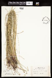 Eleocharis erythropoda Steudel 443185[1020222]Lakela, Olga 132781951-07-13 United States, Minnesota, Saint Louis, Hotel grounds, Kettle Falls, Rainy Lake.;Voyageurs National Park;070N;18W;, 48.49944 -92.63889 |
MIN:Plants | 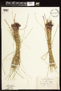 Eleocharis erythropoda Steudel 443186[1102590]Lakela, Olga 132791951-07-13 United States, Minnesota, Saint Louis, Hotel grounds at Kettle Falls, Rainy Lake, St. Louis Co.;Voyageurs National Park;070N;18W;, 48.521444 -92.665357 |
MIN:Plants | 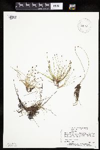 Eleocharis ovata (Roth) Roemer & Schultes 453680[1020466]Myhre, K. 43061993-08-03 United States, Minnesota, Pine, Along the Nemadji River at Maheu Lake. NE1/4 of NE1/4 of section.;;045N;17W;08, 46.395828 -92.519057 |
MIN:Plants | 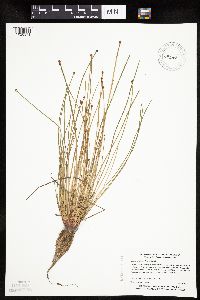 Eleocharis obtusa (Willdenow) Schultes 453681[1020371]Myhre, K. 44481993-08-10 United States, Minnesota, Pine, Saint Croix State Forest. Pine County ... Located just east of the public access to the St. Croix River, one half mile north of ... Danbury ... T 41N R 16W SE1/4 of SE1/4 of Sec 21. 041N 16W 21, 46.020737 -92.372456 |
MIN:Plants |  Eleocharis ovata (Roth) Roemer & Schultes 455798[1020501]Myhre, K. 32931992-09-08 United States, Minnesota, Cass, Cass County...Located on the south shore of Football Lake...T 141N R 28W NE1/4 of SW1/4 of Sec 10;Chippewa National Forest / Leech Lake Indian Reservation;141N;28W;10, 47.044973 -94.214977 |
MIN:Plants |  Eleocharis ovata (Roth) Roemer & Schultes 455817[1020535]Myhre, K. 31641992-08-19 United States, Minnesota, Cass, Aitkin Co.; located 3 miles west of Pine Mountain Lake; small lake; T 139N R 31W NW1/4 of NE1/4 of Sec 33;Foothills State Forest;139N;31W;33, 46.811988 -94.607677 |
MIN:Plants |  Eleocharis obtusa (Willdenow) Schultes 456826[1020449]Smith, Welby 146811988-08-04 United States, Minnesota, Mille Lacs, Mille Lacs County ... About 11 miles north of Milaca ... in the Rum River ... SW1/4 SE1/4 sec. 26, T 40N R 27W;;040N;27W;26, 45.9249992 -93.6680527 |
MIN:Plants |  Eleocharis ovata (Roth) Roemer & Schultes 456903[1020462]Mensing, D. 95-22131995-08-17 United States, Minnesota, Pine, Pine Co. T42N R17W NE1/4 of the SW1/4 of S36; Graces Lake;Saint Croix State Forest;042N;17W;36, 46.077297 -92.436151 |
MIN:Plants | 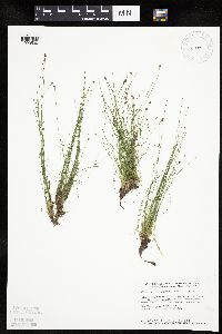 Eleocharis ovata (Roth) Roemer & Schultes 458821[1020530]Smith, Welby 147101988-08-04 United States, Minnesota, Benton, Wisneski Wildlife Area. Benton County ... Wisneski State Wildlife Management Area, about 5 miles due east of Rice ... SE1/4 SE1/4 sec.30, T 38N R 30W. 038N 30W 30, 45.753334 -94.1166687 |
MIN:Plants | 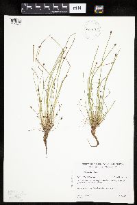 Eleocharis obtusa (Willdenow) Schultes 459002[1020373]Gerdes, Lynden 23741997-08-22 United States, Minnesota, Aitkin, Rice Lake National Wildlife Refuge. Aitkin County ... T47N R24W S25NWNW. Aitkin Co.; Rice Lake NWR, approx. 5.0 miles SSW of McGregor. In gravel pit west of refuge service road.. 047N 24W 25, 46.52637 -93.316426 |
MIN:Plants | 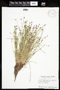 Eleocharis ovata (Roth) Roemer & Schultes 460551[1020523]Smith, Welby 146021988-07-25 United States, Minnesota, Pine, Nemadji State Forest. Pine Co.; Along the west shore of Pickeral Lake, about 5 miles south-southwest of Holyoke; SE1/4 SW1/4 section 1 T 45N R 17W. 045N 17W 1, 46.4047241 -92.4394455 |
MIN:Plants | 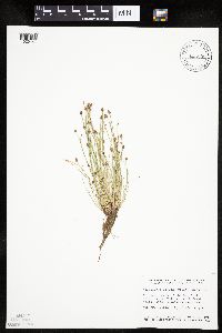 Eleocharis obtusa (Willdenow) Schultes 460840[1020441]Smith, Welby 145881988-07-22 United States, Minnesota, Washington, Washington County ... St. Croix River at the Valley Branch Creek delta ... SW1/4 SW1/4 section 14, T 28N R 20W;;028N;20W;14, 44.912738 -92.771768 |
MIN:Plants |  Eleocharis ovata (Roth) Roemer & Schultes 460930[1020519]Delaney, B. 97125.01997-09-09 United States, Minnesota, Carlton, Carlton Co.; along the St. Louis River at the mouth of Crystal Creek; 1.5 miles north of Carlton.;;049N;16W;31, 46.68512 -92.417555 |
MIN:Plants |  Eleocharis ovata (Roth) Roemer & Schultes 460990[1102707]Myhre, K. 32921992-08-09 United States, Minnesota, Cass, Cass Co.; Located on the south shore of Football Lake; T 141N R 28W NE1/4 of SW1/4 of Sec 10;Chippewa National Forest / Leech Lake Indian Reservation;141N;28W;10, 47.044973 -94.214977 |
MIN:Plants |  Eleocharis ovata (Roth) Roemer & Schultes 471982[1020469]Myhre, K. 32361992-08-31 United States, Minnesota, Cass, Cass Co.; located on the west shore of Spider Lake; T 137N R 32W NW1/4 of NE1/4 of Sec 24;Foothills State Forest;137N;32W;24, 46.666344 -94.670409 |
MIN:Plants |  Eleocharis ovata (Roth) Roemer & Schultes 471983[1020500]Myhre, K. 27181992-07-14 United States, Minnesota, Cass, Cass Co.; located one quarter mile north of Cub Lake; T 141N R 30W SW1/4 of NW1/4 of Sec 34;Chippewa National Forest;141N;30W;34, 46.987154 -94.460055 |
MIN:Plants |  Eleocharis obtusa (Willdenow) Schultes 475367[1020443]Smith, Welby 146321988-07-25 United States, Minnesota, Kanabec, Kanabec County ... On the west bank of the Snake River, just south of the Highway 3 crossing ... NE1/4 NW1/4 section 22, T 41N R 23W. 041N 23W 22, 46.0238876 -93.2333298 |
MIN:Plants |  Eleocharis obtusa (Willdenow) Schultes 478761[1020439]Myhre, K. 32741992-09-02 United States, Minnesota, Cass, Cass County...Located one eighth of a mile east of Thirty Six Lake along Wabedo Creek...small creek...T 140N R 28W NE1/4 of SE1/4 of sec 36. 140N 28W 36, 46.89815 -94.164021 |
MIN:Plants |  Eleocharis obtusa (Willdenow) Schultes 478762[1020375]Myhre, K. 33291992-09-21 United States, Minnesota, Cass, Cass County...Located on the southwest shore of Little Sand Lake...T 142N R 26W NE1/4 of SW1/4 of sec 28;Chippewa National Forest;142N;26W;28, 47.085435 -93.97655 |
MIN:Plants |  Eleocharis obtusa (Willdenow) Schultes 488749[1020388]Moore, John; Huff, N. 199001947-10-18 United States, Minnesota, Pine, Pine County ... along the St. Croix River, St. Croix State Park.;Saint Croix State Park;;;, 45.970297 -92.588337 |
MIN:Plants | 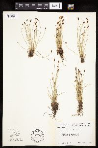 Eleocharis erythropoda Steudel 497360[1020193]Moore, John 202091949-06-21 United States, Minnesota, Lake of the Woods, Lake of the Woods County ... Growing at Long Point on Lake of the Woods.;;164N;34W;, 49.017853 -95.025935 |
MIN:Plants | 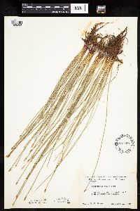 Eleocharis erythropoda Steudel 497459[1020206]Moore, John 203031949-06-23 United States, Minnesota, Stearns, Stearns County ... 5 miles south of Albany.;;124N;31W;, 45.542062 -94.572417 |
MIN:Plants | 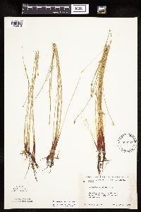 Eleocharis erythropoda Steudel 500757[1020213]Moore, John 204291949-07-06 United States, Minnesota, Douglas, Douglas County...Along the shore of Lake Victoria, 1-1/2 mi. east of Alexandria.;;128N;37W;, 45.88947 -95.325395 |
MIN:Plants | 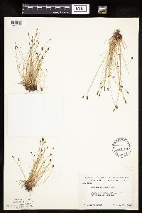 Eleocharis erythropoda Steudel 501169[1020207]Moore, John 203881949-06-29 United States, Minnesota, Roseau, Roseau County ... Lake of the Woods at Warroad.;;163N;36W;, 48.930291 -95.287489 |
MIN:Plants | 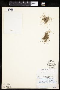 Eleocharis ovata (Roth) Roemer & Schultes 506723[1020566]Rosendahl, C. 79411950-10-18 United States, Minnesota, Chisago, Banks of the St. Croix River, ca. 1 mi. S of Taylors Falls.;;N;;, 45.345489 -92.737347 |
MIN:Plants | 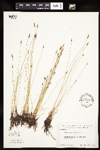 Eleocharis erythropoda Steudel 507201[1020105]Moore, John 206201950-06-19 United States, Minnesota, Martin, Martin County ... west end of Fox Lake.;;103N;32W;, 43.718131 -94.674511 |
MIN:Plants | 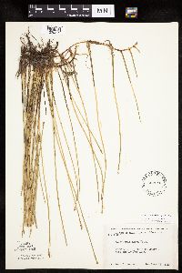 Eleocharis macrostachya Britton 507216[1020319]Moore, John 206271950-06-19 United States, Minnesota, Martin, Martin County...west end of Fox Lake.;Fox Lake Wildlife Management Area;103N;32W;, 43.718131 -94.674511 |
MIN:Plants | 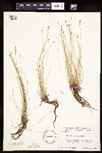 Eleocharis erythropoda Steudel 507244[1020106]Moore, John 206721950-06-20 United States, Minnesota, Martin, Martin County ... south end of Hall Lake south of Fairmont.;;102N;30W;, 43.630246 -94.430321 |
MIN:Plants |  Eleocharis erythropoda Steudel 507247[1020199]Moore, John 206691950-06-20 United States, Minnesota, Martin, Martin County ... south end of Hall Lake south of Fairmont.;;102N;30W;, 43.630246 -94.430321 |
MIN:Plants |  Eleocharis erythropoda Steudel 507302[1020176]Moore, John 207511950-06-23 United States, Minnesota, Faribault, Faribault County ... south east shore of Walnut Lake.;Walnut Lake Wildlife Management Area;103N;25W;, 43.65893 -93.78376 |
MIN:Plants |  Eleocharis ovata (Roth) Roemer & Schultes 508335[1020529]Smith, Welby 180021990-08-16 United States, Minnesota, Cook, Boundary Waters Canoe Area Wilderness / Superior National Forest. Cook County...at the N end of Frost Lake in the Boundary Waters Canoe Area Wilderness, Superior National Forest...on small stream draining into the lake from the north...T 65N R 4W SE1/4 of NW1/4 of Sec 27. 064N 04W 27, 47.996666 -90.815834 |
MIN:Plants |  Eleocharis obtusa (Willdenow) Schultes 514961[1102667]Scott, P. 9241996-08-16 United States, Minnesota, Cook, Cook Co. ... SE of Lima Mta. T63N R1W sec.1 NESWNW.;Superior National Forest;063N;01W;01, 47.968974 -90.39357 |
MIN:Plants | 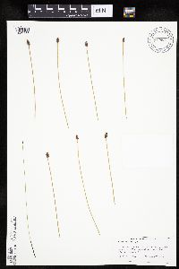 Eleocharis obtusa (Willdenow) Schultes 514962[1020438]Scott, P. 9251996-08-19 United States, Minnesota, Cook, Cook Co. ... NW side of Highway 61, 2.6 miles NE of Grand Marais Post Office. T61NR1E sec.13 or 14;North Shore / Superior National Forest;061N;01E;, 47.777456 -90.325243 |
MIN:Plants | 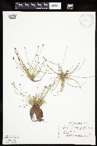 Eleocharis ovata (Roth) Roemer & Schultes 515869[1020464]Myhre, K. 31961992-08-26 United States, Minnesota, Cass, Cass Co.; located 1/4 mi SW of Widow Lake; NE shore of Sand Lake; T140N R29W NW1/4 of SW1/4 of sec 27;;140N;29W;27, 46.913942 -94.331343 |
MIN:Plants | 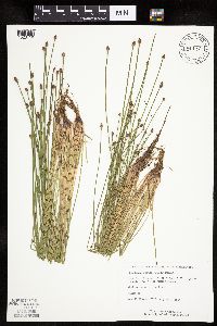 Eleocharis obtusa (Willdenow) Schultes 519182[1020419]Monson, Paul 60151984-08-02 United States, Minnesota, Cook, Grand Portage National Monument ... Cook Co, R-5E, T-64N, S-25, Logging road. 4 mi. NW of visitor center.;Grand Portage National Monument / North Shore;064N;05E;25, 47.998144 -89.748285 |
MIN:Plants | 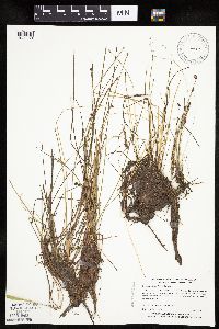 Eleocharis obtusa (Willdenow) Schultes 519724[1020374]Myhre, K. 44541993-08-16 United States, Minnesota, Pine, Pine County ... Located 2.5 mi NE of the town of Nickerson ... NW shore of Net Lake ...T45N R17W NE1/4 of NE1/4 of Sec 2;;045N;17W;02, 46.410448 -92.456597 |
MIN:Plants | 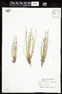 Eleocharis obtusa (Willdenow) Schultes 520121[1020422]Smith, Welby 192831991-07-09 United States, Minnesota, Koochiching, Pine Island State Forest. Koochiching County ... About 5 miles southwest of Big Falls. Along Hickes Ridge Road, about 0.5 mile north of US Hwy 71 ... abandoned gravel pit ... T 154N R 25W NE1/4 of SW1/4 [etc. 154N 25W 30, 48.127224 -93.8974991 |
MIN:Plants | 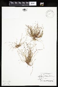 Eleocharis ovata (Roth) Roemer & Schultes 520156[1020578]Myhre, K. 34441992-10-07 United States, Minnesota, Cass, Cass Co.; located on the SW shore of Crooked Lake; T139N R30W SW1/4 of SW1/4 of Sec 9;;139N;30W;9, 46.871053 -94.480771 |
MIN:Plants | 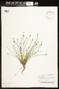 Eleocharis ovata (Roth) Roemer & Schultes 520164[1102697]Myhre, K. 32001992-08-26 United States, Minnesota, Cass, Cass Co.; located 1/4 mile SW of Widow Lake; NE shore of Sand Lake; T140N R29W NW1/4 of SW1/4 of Sec 27;;140N;29W;27, 46.913942 -94.331343 |
MIN:Plants | 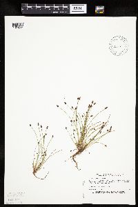 Eleocharis ovata (Roth) Roemer & Schultes 520498[1020493]Myhre, K. 30771992-08-14 United States, Minnesota, Cass, Cass Co.; located 1 mile NW of Lake Ada; T139N R29W NE1/4 of NW1/4 of Sec 21;;139N;29W;21, 46.841876 -94.352798 |
MIN:Plants | 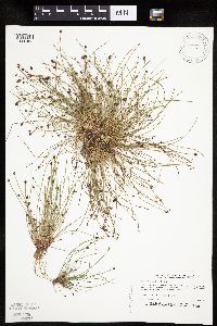 Eleocharis ovata (Roth) Roemer & Schultes 520666[1020463]Myhre, K. 30201992-08-11 United States, Minnesota, Cass, Cass Co.; located 1/2 mi SE of Pike Bay in Cass Lake; Camp Lake; T145N R31W SW1/4 of SE1/4 of Sec 36;Chippewa National Forest / Leech Lake Indian Reservation;145N;31W;36, 47.330789 -94.554707 |
MIN:Plants | 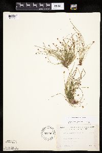 Eleocharis ovata (Roth) Roemer & Schultes 525705[1020575]Lakela, Olga 194601955-09-03 United States, Minnesota, Saint Louis, W of Toimi.;;N;;, 47.400477 -91.792388 |
MIN:Plants | 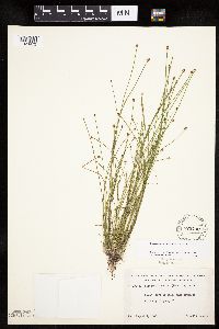 Eleocharis ovata (Roth) Roemer & Schultes 525732[1020472]Lakela, Olga 191651955-08-09 United States, Minnesota, Saint Louis, Shore of a small lake S of Gilbert, Hwy. 20.;;N;;, 47.414612 -92.448574 |
MIN:Plants | 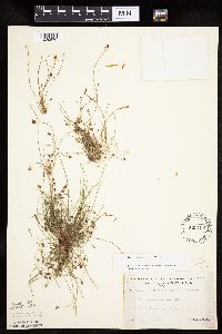 Eleocharis ovata (Roth) Roemer & Schultes 525789[1020570]Lakela, Olga 194381955-09-03 United States, Minnesota, Lake, At Toimi.;;N;;, 47.400477 -91.767669 |
MIN:Plants | 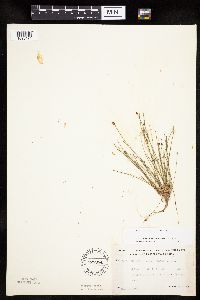 Eleocharis ovata (Roth) Roemer & Schultes 525954[1020474]Lakela, Olga 188321955-07-14 United States, Minnesota, Saint Louis, S of Island Lake, Cloquet River.;;;;, 47.01631 -92.18559 |
MIN:Plants | 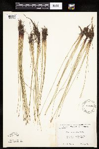 Eleocharis erythropoda Steudel 526346[1020183]Moore, John 212001951-08-07 United States, Minnesota, Wilkin, Wilkin County ... 9 mi. north east of Manston. [the village was in sec. 20/21];;136N;45W;, 46.587347 -96.342638 |
MIN:Plants | 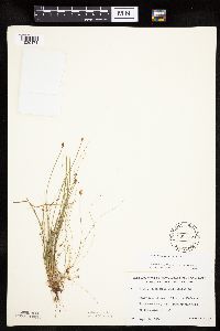 Eleocharis ovata (Roth) Roemer & Schultes 532555[1020471]Lakela, Olga 211131956-09-14 United States, Minnesota, Saint Louis, Banks of the Prairie River, N side on Rasmussen Road. Most southwesterly part of the county by road.;;N;;, 46.7963 -93.03184 |
MIN:Plants | 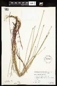 Eleocharis erythropoda Steudel 533111[1020221]Lakela, Olga; et al. 206871956-08-07 United States, Minnesota, Saint Louis, St. Louis County ... Bullet Lake Narrows, Superior National Forest, N of Ely;Boundary Waters Canoe Area Wilderness / Superior National Forest;065N;12W;12, 48.12918 -91.809522 |
MIN:Plants | 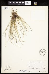 Eleocharis erythropoda Steudel 541377[1020212]Scharf, J. s.n.1956-07-12 United States, Minnesota, Murray, Murray County...State-owned wetland 9 mi. n. and 4 mi. w. of Lake Wilson.;Lange Marsh Wildlife Management Area;108N;43W;, 44.153008 -96.003558 |
MIN:Plants | 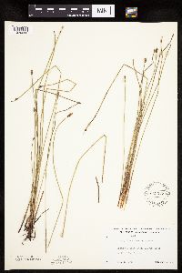 Eleocharis erythropoda Steudel 543372[1020220]Lakela, Olga 220611957-08-17 United States, Minnesota, Lake, Lake County ... near Little Cloquet River, north of Two Harbors;Superior National Forest;056N;10W;07, 47.350293 -91.653677 |
MIN:Plants | 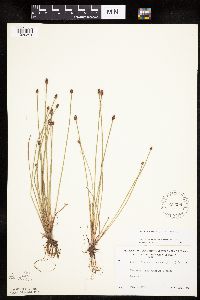 Eleocharis obtusa (Willdenow) Schultes 543398[1020391]Lakela, Olga 217711957-08-03 United States, Minnesota, Lake, Lake County ... Lake Superior terrace, Larsmont.;North Shore;052N;11W;21, 46.978134 -91.747105 |
MIN:Plants | 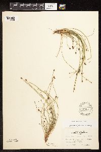 Eleocharis ovata (Roth) Roemer & Schultes 543413[1102695]Lakela, Olga 225221957-09-17 United States, Minnesota, Saint Louis, Southern boundary of St. Louis county.;;N;;, 46.851173 -92.516398 |
MIN:Plants | 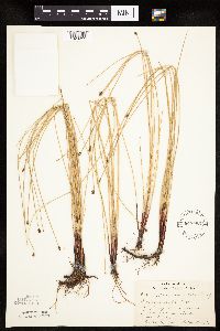 Eleocharis erythropoda Steudel 543595[1020211]Lakela, Olga 64051946-07-13 United States, Minnesota, Cook, Highway 61, 2 miles from Lake Co. line. Cook Co.;Finland State Forest / North Shore;058N;05W;, 47.517398 -90.978352 |
MIN:Plants | 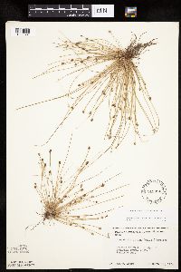 Eleocharis obtusa (Willdenow) Schultes 549894[1020381]Moore, John 221551954-09-17 United States, Minnesota, Sherburne, Sherburne County ... Sect. 1, Santiago Twp.;;035N;28W;01, 45.552286 -93.769525 |
MIN:Plants | 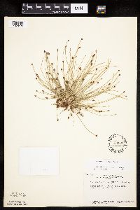 Eleocharis ovata (Roth) Roemer & Schultes 553600[1020576]Bernardini, J.; Moore, John 1301958-09-18 United States, Minnesota, Blue Earth, N shore of Eagle Lake.;;N;;, 44.239564 -93.94897 |
MIN:Plants | 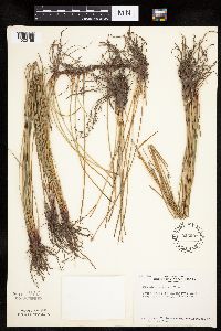 Eleocharis erythropoda Steudel 553601[1020169]Bernardini, J.; Moore, John 1291958-09-18 United States, Minnesota, Blue Earth, South shore of Ballantyne Lake, Blue Earth County;;109N;25W;, 44.239469 -93.828345 |
MIN:Plants | 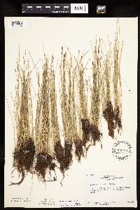 Eleocharis erythropoda Steudel 553618[1020198]Bernardini, J.; Moore, John 1391958-09-19 United States, Minnesota, Blue Earth, 1 mi. west of Mankato on Minnesota River bank, Blue Earth County;;108N;27W;, 44.152457 -94.068583 |
MIN:Plants | 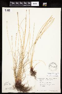 Eleocharis palustris (L.) Roemer & Schultes 554148[1020748]Moore, John 224621955-05-31 United States, Minnesota, Sibley, Sibley County...west shore of High Island Lake at New Auburn.;;114N;28W;, 44.674053 -94.193315 |
MIN:Plants | 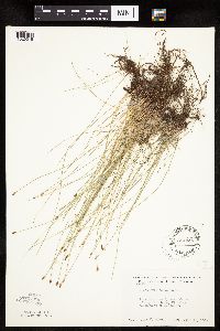 Eleocharis erythropoda Steudel 554445[1020215]Moore, John 232951957-06-19 United States, Minnesota, Martin, Martin County ... east shore of Big Twin Lake, 2-1/2 mi. south west of Monterey.;;103N;33W;, 43.718294 -94.794347 |
MIN:Plants | 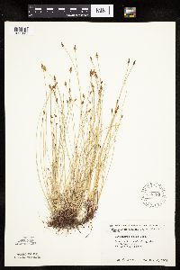 Eleocharis erythropoda Steudel 558482[1020143]Moore, John 237581958-05-28 United States, Minnesota, Blue Earth, Blue Earth County ... south west side of Lake Washington.;;109N;25W;, 44.239469 -93.828345 |
MIN:Plants | 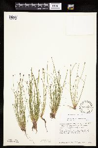 Eleocharis ovata (Roth) Roemer & Schultes 561091[1020492]Ownbey, Gerald 22431955-07-04 United States, Minnesota, Hubbard, Itasca State Park. Hwy. 71, 3 mi. S of its jct. with Hwy. 92.;Itasca State Park;143N;34W;, 47.195969 -94.982379 |
MIN:Plants | 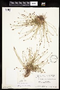 Eleocharis ovata (Roth) Roemer & Schultes 566341[1020569]Moore, John; Bernardini, J. 242801958-09-18 United States, Minnesota, Blue Earth, S shore of Ballantyne Lake.;;109N;25W;, 44.239469 -93.828345 |
MIN:Plants | 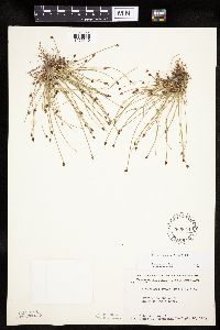 Eleocharis ovata (Roth) Roemer & Schultes 566644[1020540]Moore, John; Bernardini, J. 242771958-09-18 United States, Minnesota, Blue Earth, N shore of Eagle Lake.;;N;;, 44.239564 -93.94897 |
MIN:Plants | 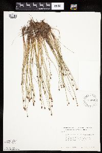 Eleocharis obtusa (Willdenow) Schultes 572582[1020408]Moore, John 255531961-07-05 United States, Minnesota, Anoka, Anoka County ... near entrance to Cedar Creek Natural History Area laboratory grounds.;Cedar Creek National History Area;034N;23W;, 45.428063 -93.203997 |
MIN:Plants | 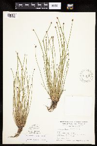 Eleocharis obtusa (Willdenow) Schultes 575058[1020404]Wertman, Freida 1611960-07-20 United States, Minnesota, Anoka, Anoka County ... Cedar Creek Natural History Area ... Athens Twp. Section 27. Section 27 s.w.; County Road 24 north side;Cedar Creek National History Area;034N;23W;27, 45.406779 -93.193727 |
MIN:Plants | 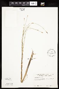 Eleocharis erythropoda Steudel 576829[1020094]Isaak, Daniel s.n.1960-06-21 United States, Minnesota, Isanti, Isanti County ... Horseshoe Lake, Sections 2 and 11, Township 34 North and Range West.22;;034N;22W;, 45.427323 -93.081077 |
MIN:Plants | 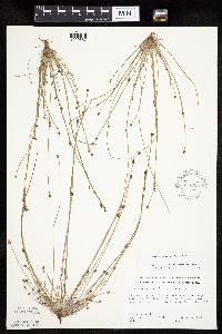 Eleocharis ovata (Roth) Roemer & Schultes 578731[1020567]Ownbey, Gerald; Bloom, W. 34011962-08-20 United States, Minnesota, Clearwater, NW corner of Lower Red Lake, ca. 0.3 mi. from the shore.;Red Lake Indian Reservation;152N;36W;10, 47.957544 -95.277636 |
MIN:Plants | 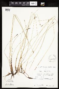 Eleocharis erythropoda Steudel 578880[1020125]Ownbey, Gerald 32571962-07-22 United States, Minnesota, Clearwater, Clearwater County ... Itasca State Park. Near Mississippi Headwaters. T 143 N, R 36 W, NW 1/4 Sect. 2;Itasca State Park;143N;36W;02, 47.231973 -95.201528 |
MIN:Plants | 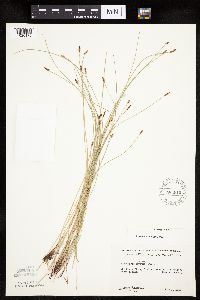 Eleocharis erythropoda Steudel 583919[1020175]Gundersen, R. 1961-07-03 United States, Minnesota, Washington, Washington County ... St. Croix River, 3 mi north of Stillwater. Large island;Saint Croix National Riverway;030N;20W;00, 45.084979 -92.817348 |
MIN:Plants | 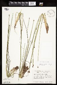 Eleocharis ovata (Roth) Roemer & Schultes 584557[1020514]Ownbey, Gerald 35991963-07-30 United States, Minnesota, Becker, Becker Co. Along Hwy. 113, ca. 4.2 mi. W of its jct. with Hwy. 71. T142N R36W Sec.10 NW1/4.;;142N;36W;10, 47.130749 -95.222764 |
MIN:Plants | 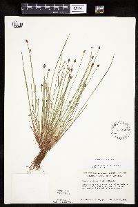 Eleocharis ovata (Roth) Roemer & Schultes 584582[1020555]Ownbey, Gerald 36121963-07-30 United States, Minnesota, Becker, Becker Co. Along Hwy. 113, 1.5 E of Bad Medicine Lake.;White Earth Indian Reservation / White Earth State Forest;142N;37W;3, 47.144389 -95.350347 |
MIN:Plants | 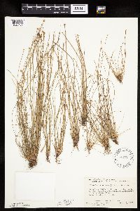 Eleocharis obtusa (Willdenow) Schultes 586371[1020407]Bernardini, J.; Moore, John 1501961-10-05 United States, Minnesota, Anoka, ca. 1 mi. north of the Nat. History area Station Laboratory of Cedar Creek Forest. Anoka County;Cedar Creek National History Area;034N;23W;, 45.428063 -93.203997 |
MIN:Plants | 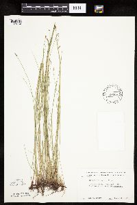 Eleocharis erythropoda Steudel 586422[1020166]Moore, John 264001963-06-27 United States, Minnesota, Blue Earth, Blue Earth County ... Cobb River, 5 mi. south east of Mankato.;;;;, 44.152568 -93.948763 |
MIN:Plants | 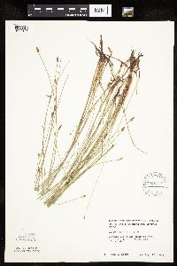 Eleocharis erythropoda Steudel 591950[1020128]Moore, John 267881965-08-12 United States, Minnesota, Blue Earth, Blue Earth County ... Minnesota River, 2 miles west of Mankato.;;108N;27W;, 44.152457 -94.068583 |
MIN:Plants | 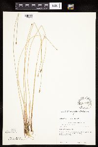 Eleocharis erythropoda Steudel 594462[1020224]Thorne, Robert 306641962-06-25 United States, Minnesota, Clearwater, Clearwater County ... Floating Bog Bay, between N and E arms, Lake Itasca, Itasca State Park.;Itasca State Park;143N;36W;11, 47.217521 -95.201495 |
MIN:Plants | 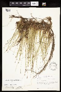 Eleocharis erythropoda Steudel 594496[1020091]Thorne, Robert 307451962-06-29 United States, Minnesota, Clearwater, Clearwater County ... near bathing beach, near N end of Lake Itasca, Itasca State Park. NE 1/4 Sec. 2, T0143N, R-36W;Itasca State Park;143N;36W;02, 47.231973 -95.201528 |
MIN:Plants | 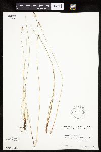 Eleocharis erythropoda Steudel 611524[1020201]Lammers, Roberta s.n.1967-06-09 United States, Minnesota, Isanti, Isanti County ... near Beckman Lake, Cedar Creek Natural History Area.;Cedar Creek National History Area;034N;23W;, 45.428063 -93.203997 |
MIN:Plants | 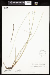 Eleocharis erythropoda Steudel 614600[1020204]Westkaemper, Remberta s.n.1969-06-00 United States, Minnesota, Stearns, Stearns County ... Sauk Center.;;126N;34W;, 45.71615 -94.953516 |
MIN:Plants | 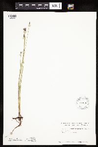 Eleocharis erythropoda Steudel 614630[1020205]Westkaemper, Remberta s.n.1969-06-00 United States, Minnesota, Stearns, Stearns County ... Roscoe.;;;;, 45.433853 -94.639725 |
MIN:Plants | 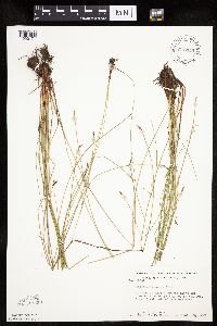 Eleocharis erythropoda Steudel 615944[1020171]Moore, John; Moore, Marjorie 273011969-09-20 United States, Minnesota, Anoka, Anoka County ... north shore of Fish Lake, Bethel Twp, Cedar Creek Natural History Area.;Cedar Creek National History Area;034N;23W;, 45.428063 -93.203997 |
MIN:Plants | 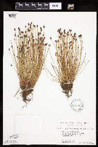 Eleocharis obtusa (Willdenow) Schultes 616614[1020406]Moore, John; Moore, Marjorie 2761969-07-11 United States, Minnesota, Crow Wing, Crow Wing Natural History Area. Crow Wing County ... S.E. corner of the S.E. 1/4, Sect. 6, Garrison Twp.;Crow Wing Natural Area;044N;28W;06, 46.323097 -93.926287 |
MIN:Plants | 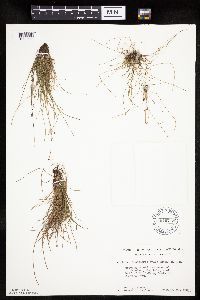 Eleocharis ovata (Roth) Roemer & Schultes 616753[1020560]Moore, John 5211969-09-26 United States, Minnesota, Crow Wing, Cranberry Lake Bog.;;044N;28W;, 46.265142 -93.904498 |
MIN:Plants | 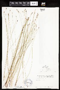 Eleocharis erythropoda Steudel 619253[1020179]Westkaemper, Remberta s.n.1969-07-00 United States, Minnesota, Stearns, Stearns County ... SBC [St. Benedict's College] Woods, St. Joseph.;;124N;29W;, 45.543642 -94.322053 |
MIN:Plants | 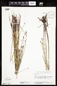 Eleocharis palustris (L.) Roemer & Schultes 623099[1020734]Moore, John; et al. 274091971-07-06 United States, Minnesota, Isanti, Isanti County...west side of Beckman Lake, Athens Twp. Cedar Creek Natural History Area.;Cedar Creek National History Area;034N;23W;, 45.428063 -93.203997 |
MIN:Plants | 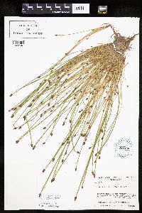 Eleocharis ovata (Roth) Roemer & Schultes 631300[1020543]Richards, Donald; et al. 17701971-08-21 United States, Minnesota, Itasca, Itasca County...N shore of Deer Lake, 18 mi. NW of Grand Rapids...along Hwy. 19.;;;;, 47.390143 -93.664557 |
MIN:Plants | 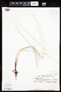 Eleocharis erythropoda Steudel 670597[1020134]Heitlinger, M. 2171971-07-07 United States, Minnesota, McLeod, McLeod Co, Schaefer Prairie...SE 1/4 of Sec 34, T 115N, R 29W...west of the prominent N-S ridge.;Schaefer Prairie, The Nature Conservancy;115N;29W;34, 44.72505 -94.30491 |
MIN:Plants | 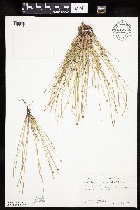 Eleocharis obtusa (Willdenow) Schultes 676221[1020448]Clemants, Steven 5541976-09-02 United States, Minnesota, Sherburne, Sherburne County ... Approximately 1 mi. N of town of Clearwater, T 34 N, R 30 W, Sect. 23, SW 1/4. Mississippi river;;034N;30W;23, 45.422477 -94.036033 |
MIN:Plants | 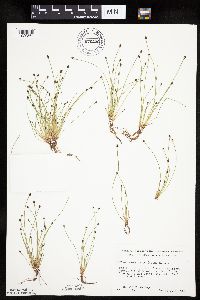 Eleocharis ovata (Roth) Roemer & Schultes 676316[1020564]Ownbey, Gerald 50161975-07-25 United States, Minnesota, Cook, In a gravel pit on the paved road from Grand Portage to Hat Point, ca. 1.0 mi. E of Grand Portage.;Grand Portage Indian Reservation / North Shore;064N;06W;, 47.962385 -89.661808 |
MIN:Plants | 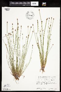 Eleocharis obtusa (Willdenow) Schultes 676325[1020427]Ownbey, Gerald 54601976-08-29 United States, Minnesota, Washington, Afton State Park. Washington County ... T 127 N, R 20 W, NW 1/4 Sect. 2. Afton State Park ... along delta of Trout Brook at its confluence with St. Croix River.. 027N 20W 2, 44.854763 -92.775046 |
MIN:Plants | 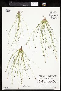 Eleocharis ovata (Roth) Roemer & Schultes 676326[1020498]Ownbey, Gerald 52421976-08-06 United States, Minnesota, Clearwater, Itasca State Park. S shore of Mink Lake.;Itasca State Park;143N;36W;7, 47.216898 -95.286535 |
MIN:Plants | 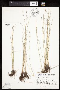 Eleocharis erythropoda Steudel 676327[1020110]Ownbey, Gerald 1976-08-29 United States, Minnesota, Washington, Afton State Park. Washington County ... T 127 N, R 20 W, NW 1/4, Sect. 2. Afton State Park ... Trout Brook at its confluence with the St. Croix River.. 027N 20W 2, 44.854763 -92.775046 |
MIN:Plants | 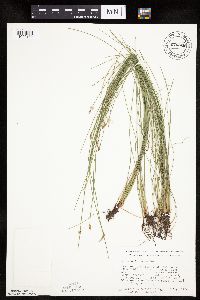 Eleocharis erythropoda Steudel 676328[1020182]Ownbey, Gerald; et al. 53441976-08-26 United States, Minnesota, Houston, Houston County ... Rte. 26, 1.3 miles N of the Iowa border (New Albin).;Dorer Memorial Hardwood State Forest;101N;04W;, 43.543897 -91.312564 |
MIN:Plants | 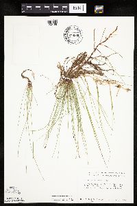 Eleocharis erythropoda Steudel 676329[1020196]Ownbey, Gerald 53101976-08-16 United States, Minnesota, Clearwater, Clearwater County...T 151 N, R 36 W, SW 1/4, Sect. 23. Lower Red Lake, Rte. 89.;;151N;36W;23, 47.877853 -95.23388 |
MIN:Plants | 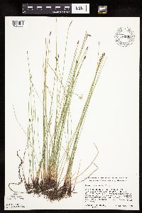 Eleocharis erythropoda Steudel 676330[1020096]Ownbey, Gerald 52771976-08-12 United States, Minnesota, Norman, Norman County ... T 144 N, R 46 W, SE 1/4 Sect. 11. 2.7 miles E of jct. of Rte. 200 and Co. Rte. 9 at Ada ... drainage of the former Long Lake where it crosses Rte. 200.. 144N 46W 11, 47.303312 -96.468288 |
MIN:Plants | 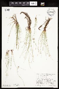 Eleocharis erythropoda Steudel 676331[1020097]Ownbey, Gerald 52761976-08-12 United States, Minnesota, Norman, Norman County ... T 144 N, R 46 W, SE 1/4, Sect. 11. 2.7 mi. E of jct. of Rte. 200 and Co. Rte. 9 at Ada ... former Long Lake where it crosses Rte. 200.. 144N 46W 11, 47.303312 -96.468288 |
MIN:Plants | 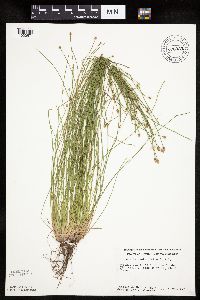 Eleocharis ovata (Roth) Roemer & Schultes 676333[1020571]Ownbey, Gerald; et al. 53451976-08-26 United States, Minnesota, Houston, Houston Co. Rt. 26, 1.3 mi. N of the Iowa border.;Dorer Memorial Hardwood State Forest;101N;04W;, 43.543897 -91.312564 |
MIN:Plants | 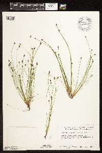 Eleocharis ovata (Roth) Roemer & Schultes 676335[1102696]Ownbey, Gerald 52361976-08-02 United States, Minnesota, Clearwater, Itasca State Park. E end of Bohall Lake.;Itasca State Park;143N;36W;, 47.19557 -95.233216 |
MIN:Plants | 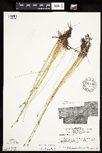 Eleocharis erythropoda Steudel 680993[1020244]Swanson, Steven 5361975-06-16 United States, Minnesota, Houston, Mississippi River (Navigation Pool #8)...Houston Co, Site 18...west shore;Upper Mississippi National Wildlife Refuge;;;, 43.801454 -91.319283 |
MIN:Plants | 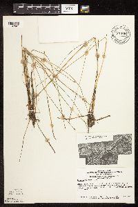 Eleocharis erythropoda Steudel 681108[1102587]Swanson, Steven 9271975-06-25 United States, Minnesota, Houston, Mississippi River (Navigation Pool #8) ... Houston Co, Site 29;Upper Mississippi National Wildlife Refuge;;;, 43.771295 -91.250286 |
MIN:Plants | 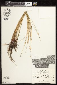 Eleocharis erythropoda Steudel 681519[1102588]Swanson, Steven 8971975-06-25 United States, Minnesota, Houston, Mississippi River (Navigation Pool #8) ... Houston Co, Site 28 ... [east of] railroad levee.;Upper Mississippi National Wildlife Refuge;;;, 43.771295 -91.250286 |
Google Map
Google Maps is a web mapping service provided by Google that features a map that users can pan (by dragging the mouse) and zoom (by using the mouse wheel). Collection points are displayed as colored markers that when clicked on, displays the full information for that collection. When multiple species are queried (separated by semi-colons), different colored markers denote each individual species.