University of Minnesota
http://www.umn.edu/
612-625-5000
http://www.umn.edu/
612-625-5000
Minnesota Biodiversity Atlas
Bell Museum
Dataset: MIN-Plants
Taxa: Eleocharis
Search Criteria: excluding cultivated/captive occurrences
Bell Museum plants | |
 MIN:Plants |  Eleocharis palustris (L.) Roemer & Schultes 745939[1020686]Smith, Welby 43301981-06-21 United States, Minnesota, Wright, Wright Co.; W arm of Lake John, about 2 mi. W of Annandale. SW1/4 SW1/4 of sec.23, T121N R28W;;121N;28W;23, 45.275205 -94.168758 |
MIN:Plants |  Eleocharis palustris (L.) Roemer & Schultes 746356[1020668]Smith, Welby 45171981-06-25 United States, Minnesota, Wright, Wright Co.; SW arm of Pelican Lake, about 5 mi. NE of Buffalo. NW1/4 SE1/4 of sec.12, T120N R25W;;120N;25W;12, 45.216197 -93.775961 |
MIN:Plants |  Eleocharis palustris (L.) Roemer & Schultes 746920[1020742]Richter, D. s.n.1981-07-05 United States, Minnesota, Kandiyohi, County: Kandiyohi...Sibley State Park.;Sibley State Park;121N;35W;, 45.282269 -95.070706 |
MIN:Plants |  Eleocharis palustris (L.) Roemer & Schultes 773662[1020669]Boe, J. 11541979-07-29 United States, Minnesota, Lake of the Woods, Northwest Angle. Old Feldspar Mine site.;Northwest Angle;167N;33W;6, 49.316302 -94.948691 |
MIN:Plants |  Eleocharis palustris (L.) Roemer & Schultes 773663[1020667]Boe, J. 11861979-07-29 United States, Minnesota, Lake of the Woods, Lake of the Woods, just N of Sugar Point, Northwest Angle.;Northwest Angle;167N;33W;17, 49.287332 -94.926586 |
MIN:Plants |  Eleocharis palustris (L.) Roemer & Schultes 773670[1020665]Boe, J. 12261979-08-02 United States, Minnesota, Lake of the Woods, Winter Road River, where Hwy. 72 crosses NW of Baudette.;;161N;31W;20, 48.750633 -94.663746 |
MIN:Plants |  Eleocharis palustris (L.) Roemer & Schultes 774312[1020683]Monson, Paul 52121982-07-29 United States, Minnesota, Saint Louis, Mud Bay, Kabetogama Lake.;Voyageurs National Park;069N;20W;29, 48.434441 -92.929442 |
MIN:Plants |  Eleocharis palustris (L.) Roemer & Schultes 780474[1020720]Ownbey, Gerald 69201984-07-07 United States, Minnesota, Clearwater, S side of Rte. 200, 1.2 mi. SE of its jct. with Rte. 7 in the town of Roy Lake.;White Earth Indian Reservation;144N;38W;, 47.281836 -95.487753 |
MIN:Plants |  Eleocharis erythropoda Steudel 782675[1020158]Tenney, M. 3361982-07-01 United States, Minnesota, Fillmore, Forestville State Park. Fillmore County...T. 102N R. 12W Sec. 24 S1/2 SE1/4 NW1/4.;Forestville State Park;102N;12W;24, 43.623411 -92.219152 |
MIN:Plants |  Eleocharis palustris (L.) Roemer & Schultes 787129[1020635]Maxson, George-Ann s.n.1981-06-24 United States, Minnesota, Lake of the Woods, Pickeral Creek.;;167N;33W;19, 49.272974 -94.948837 |
MIN:Plants |  Eleocharis palustris (L.) Roemer & Schultes 804899[1020599]Ordway, E.; Goecke, B. 91976-07-13 United States, Minnesota, Pope, Strandness Prairie. Pope County...4 mi. N of Starbuck, Minnewaska Twp. Sec. 6;Strandness Prairie, The Nature Conservancy;125N;38W;06, 45.665152 -95.500112 |
MIN:Plants |  Eleocharis palustris (L.) Roemer & Schultes 807736[1102733]Dorio, J. 2791977-06-20 United States, Minnesota, Morrison, County: Morrison. Lake Alexander. Lake Alexander.. , 46.207554 -94.541473 |
MIN:Plants |  Eleocharis palustris (L.) Roemer & Schultes 816043[1020617]Wheeler, Gerald 107391988-06-17 United States, Minnesota, Norman, Norman County...Ca. 2.5 mi. NE of Syre; E of Rte. 164...N1/2 NW1/4 SW1/4 Sec.13, T143N, R44W (Home Lake Twp.);Home Lake Wildlife Management Area;143N;44W;13, 47.201951 -96.205215 |
MIN:Plants |  Eleocharis palustris (L.) Roemer & Schultes 817641[1020700]Delaney, B. 891011989-07-19 United States, Minnesota, Sherburne, Sherburne County...along the southwest shore of Lake Ann...SE1/4 SE1/4 Sec. 21, T 34 N, R 27 W.;Sand Dunes State Forest;034N;27W;21, 45.422323 -93.704452 |
MIN:Plants |  Eleocharis NULL 81943[1102503]Moyer, Lycurgus s.n.1898-06-13 United States, Minnesota, Big Stone, near lake. Ortonville.;;121N;46W;, 45.284263 -96.412452 |
MIN:Plants |  Eleocharis palustris (L.) Roemer & Schultes 81954[1020762]Rosendahl, C.; Butters, F. 36041918-07-09 United States, Minnesota, Crow Wing, 2 mi. E of Fort Ripley.;;N;;, 46.16607 -94.31847 |
MIN:Plants |  Eleocharis palustris (L.) Roemer & Schultes 81959[1020709]Skinner, S. 251902-06-09 United States, Minnesota, Jackson, Heron Lake;;N;;, 43.771287 -95.272522 |
MIN:Plants |  Eleocharis palustris (L.) Roemer & Schultes 81960[1020761]Lange, D. s.n.1917-06-28 United States, Minnesota, Cook, Little Gunflint Lake. Cook Co.;Superior National Forest;065N;02W;00, 48.086772 -90.580816 |
MIN:Plants |  Eleocharis palustris (L.) Roemer & Schultes 81962[1102714]Sandberg, John s.n.1890-06-00 United States, Minnesota, Chisago, [no further data];;;;, 45.522134 -92.91 |
MIN:Plants |  Eleocharis palustris (L.) Roemer & Schultes 81963[1020651]Sandberg, John s.n.1885-06-00 United States, Minnesota, Chisago, Chisago Lake;;N;;, 45.360426 -92.87121 |
MIN:Plants |  Eleocharis palustris (L.) Roemer & Schultes 81964[1020628]Sheldon, Edmund S18471890-06-00 United States, Minnesota, Hennepin, Ft. Snelling;Fort Snelling Military Reservation;028N;23W;, 44.905162 -93.166462 |
MIN:Plants |  Eleocharis palustris (L.) Roemer & Schultes 81965[1020649]Sheldon, Edmund S2467?1892-06-00 United States, Minnesota, Aitkin, Nichols;;044N;27W;04, 46.32387 -93.75721 |
MIN:Plants |  Eleocharis palustris (L.) Roemer & Schultes 81968[1102713]Burglehaus, F. s.n.1891-09-00 United States, Minnesota, Hennepin, Hennepin Co.;;;;, 45.004579 -93.476877 |
MIN:Plants |  Eleocharis palustris (L.) Roemer & Schultes 81970[1020652]Anderson, A. A6691893-08-00 United States, Minnesota, Cass, Gull Lake;;N;;, 46.446379 -94.35099 |
MIN:Plants |  Eleocharis palustris (L.) Roemer & Schultes 81971[1020708]MacMillan, C.; et al. 11441894-07-00 United States, Minnesota, Lake of the Woods, Oak Point;Pine & Curry Islands Scientific Natural Area;162N;31W;06, 48.87976 -94.690246 |
MIN:Plants |  Eleocharis palustris (L.) Roemer & Schultes 81972[1020707]Arthur, J.; et al. B191886-07-18 United States, Minnesota, Saint Louis, Vermilion Lake;;;;, 47.879148 -92.351718 |
MIN:Plants |  Eleocharis palustris (L.) Roemer & Schultes 81973[1020653]Arthur, J.; et al. B5351886-07-28 United States, Minnesota, Saint Louis, Long Lake. Vermilion Lake [the only Long Lake near Vermilion Lake is now called Buck Lake];Boundary Waters Canoe Area Wilderness / Superior National Forest;063N;15W;01, 47.967669 -92.191235 |
MIN:Plants |  Eleocharis palustris (L.) Roemer & Schultes 81974[1020659]Taylor, B. T12181892-06-00 United States, Minnesota, Chisago, Center City, Chisago Co.;;034N;20W;, 45.42608 -92.83619 |
MIN:Plants |  Eleocharis palustris (L.) Roemer & Schultes 81975[1020743]Ballard, C. B9121892-06-00 United States, Minnesota, Nicollet, Nicollet;;109N;28W;, 44.239687 -94.190492 |
MIN:Plants |  Eleocharis palustris (L.) Roemer & Schultes 81976[1020650]Taylor, B. T15401892-08-00 United States, Minnesota, Chisago, Chisago City;;N;;, 45.373576 -92.889938 |
MIN:Plants |  Eleocharis macrostachya Britton 81977[1020325]Menzel, Max s.n.1895-06-00 United States, Minnesota, Pipestone, Pipestone [assuming the quarry area; town generally noted as Pipestone City by collector];Pipestone National Monument;106N;46W;01, 44.01585 -96.31767 |
MIN:Plants |  Eleocharis palustris (L.) Roemer & Schultes 81978[1020645]Taylor, B. T4061891-06-00 United States, Minnesota, Waseca, Lake Elysian, Waseca Co.;;109N;24W;, 44.17629 -93.69587 |
MIN:Plants |  Eleocharis palustris (L.) Roemer & Schultes 81979[1020676]Taylor, B. T191891-06-00 United States, Minnesota, Le Sueur, Elysian.;;109N;24W;, 44.239498 -93.707142 |
MIN:Plants |  Eleocharis palustris (L.) Roemer & Schultes 81980[1020675]Ballard, C. B14391893-07-00 United States, Minnesota, Cass, Lake Kilpatrick.;;135N;29W;, 46.500163 -94.32908 |
MIN:Plants |  Eleocharis palustris (L.) Roemer & Schultes 81982[1020737]Frost, W. T711892-06-00 United States, Minnesota, Meeker, Litchfield, Meeker Co.;;119N;31W;, 45.109214 -94.56847 |
MIN:Plants |  Eleocharis palustris (L.) Roemer & Schultes 81983[1020657]Sheldon, Edmund S31451892-07-00 United States, Minnesota, Kanabec, Mora, Kanabec Co.;;039N;24W;, 45.860683 -93.327529 |
MIN:Plants |  Eleocharis palustris (L.) Roemer & Schultes 81984[1020738]Ballard, C. B4951891-07-00 United States, Minnesota, Scott, Prior's Lake, Scott Co.;;115N;21W;, 44.753605 -93.344349 |
MIN:Plants |  Eleocharis palustris (L.) Roemer & Schultes 827987[1020664]Dana, R. 910291991-07-27 United States, Minnesota, Kittson, Kittson Co.; NE1/4 NE1/4 NE1/4 Sec.16 T160N R45W;;160N;45W;16, 48.6870003 -96.4550018 |
MIN:Plants | 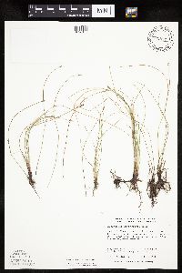 Eleocharis erythropoda Steudel 828171[1020156]Dana, R. s.n.1991-09-06 United States, Minnesota, Roseau, Roseau County...SW1/4 NW1/4 SW1/4 Sec.17 T160N R44W;Two Rivers Parkland Scientific Natural Area;160N;44W;17, 48.6769447 -96.3649979 |
MIN:Plants | 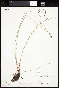 Eleocharis palustris (L.) Roemer & Schultes 831751[1020703]Harris, Fred 921431992-07-11 United States, Minnesota, Pennington, Pennington County...Goose Lake prairie-wetland complex...NW1/4 SE1/4 Sec 17 T153N R45W;;153N;45W;17, 48.072309 -96.46868 |
MIN:Plants | 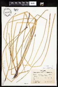 Eleocharis palustris (L.) Roemer & Schultes 832314[1020753]Saari, H. 1941-06-24 United States, Minnesota, Cook, County: Cook. Location: Dyer's Lake.;Finland State Forest / North Shore;058N;05W;, 47.517398 -90.978352 |
MIN:Plants |  Eleocharis palustris (L.) Roemer & Schultes 832317[1020621]Benson, Robert 711941-08-01 United States, Minnesota, Anoka, County: Anoka. Location: Carlos Avery Refuge. T33 R22 S32;Carlos Avery Wildlife Management Area;033N;22W;32, 45.304324 -93.111756 |
MIN:Plants | 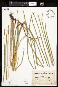 Eleocharis palustris (L.) Roemer & Schultes 832318[1020739]Moyle, J. 41211945-08-08 United States, Minnesota, Steele, County: Steele. Location: Rice L.;Rice Lake State Park;107N;19W;, 44.066335 -93.10586 |
MIN:Plants |  Eleocharis erythropoda Steudel 833827[1020152]Smith, Welby 141601988-05-31 United States, Minnesota, Lac Qui Parle, Lac Qui Parle County...About 1 mi SSE of Nassau, on the S side of County Hwy 24...east bank of Peg Lake. SE1/4 NE1/4 section 4, T118N R46W. 118N 46W 4, 45.059123 -96.424984 |
MIN:Plants |  Eleocharis erythropoda Steudel 834097[1020082]Smith, Welby 197241991-07-18 United States, Minnesota, Roseau, Roseau County ...About 4 mi N of Warroad. Sand bar in Lake of the Woods (Muskeg Bay) ... T163N R36W NE1/4 of SE1/4 of Sec.5. 163N 36W 5, 48.9661102 -95.3161087 |
MIN:Plants |  Eleocharis erythropoda Steudel 834301[1020099]Monson, Paul 44201961-06-23 United States, Minnesota, Clearwater, Clearwater Co. R-36 T-144 S-33. Sucker Creek N of Hwy. 92 [now hwy 200];Iron Springs Bog Scientific Natural Area;144N;36W;33, 47.246014 -95.244559 |
MIN:Plants |  Eleocharis palustris (L.) Roemer & Schultes 836228[1020594]Cholewa, A. 24351995-08-11 United States, Minnesota, Aitkin, Aitkin Co. Savanna Portage State Park, about 17 mi NE of McGregor, Wolf Lake at boat launch, T50 R22W S6 NE1/4 of NE1/4;Savanna Portage State Park;050N;22W;5, 46.846017 -93.154919 |
MIN:Plants |  Eleocharis erythropoda Steudel 836241[1020151]Smith, Welby 182181990-08-30 United States, Minnesota, Morrison, Mississippi River; about 1 km E of the junction of Chorwan Road and East Boundary Road. UTM: 396600E 5124800N. SE1/4 of SW1/4 of section;Camp Ripley Military Reservation;132N;29W;04, 46.2688986 -94.3418803 |
MIN:Plants | Eleocharis erythropoda Steudel 836280[]Smith, Welby 182181990-08-30 United States, Minnesota, Morrison, Camp Ripley Military Reservation. Camp Ripley Military Reservation. Morrison County ... About 1 km E of the junction of Chorwan Road and East Boundary Road ... Mississippi River ... UTM: 396600E 5124800N. T132N R29W SE1/4 of SW1/4 of Sec 4. 132N 29W 4, 46.272931 -94.344197 |
MIN:Plants |  Eleocharis palustris (L.) Roemer & Schultes 837335[1020081]Smith, Welby R. 173761990-07-18 United States, Minnesota, Morrison, Camp Ripley Military Reservation. On the E side of Luzon Road. At the SW corner of Goose Pond. UTM: 389600E 5108500N. T131N R30W NW1/4 of NW1/4 of Sec 35, 46.114708 -94.42168 |
MIN:Plants |  Eleocharis erythropoda Steudel 837397[1020086]Smith, Welby 183961990-09-13 United States, Minnesota, Morrison, Camp Ripley Military Reservation. Camp Ripley Military Reservation. Morrison County ... About 2 km NW of Crow Wing Lake ... west bank of the Mississippi River ... UTM: 394500E 5122500N. T132 R29 SW1/4 of NW1/4 of Sec 17. 132N 29W 17, 46.250437 -94.367676 |
MIN:Plants |  Eleocharis erythropoda Steudel 838336[1020161]Smith, Welby 177401990-08-07 United States, Minnesota, Red Lake, Red Lake County ... At 'Old Crossing Treaty State Wayside Park'. On the N bank of the Red Lake River, abut 6 miles W of town of Red Lake Falls ... T151N R45W SE1/4 of SW1/4 of Sec. 27. 151N 45W 27, 47.8666649 -96.4113922 |
MIN:Plants |  Eleocharis erythropoda Steudel 840538[1020123]Smith, Welby 135921987-07-27 United States, Minnesota, Washington, Rice Lake Wildlife Management Area. Washington County ... Rice Lake State Wildlife Management Area, about 1 mi E of Hugo. SE1/4 NE1/4 sec.21, T31N R21W ... Rice Lake.. 031N 21W 21, 45.161297 -92.960423 |
MIN:Plants |  Eleocharis erythropoda Steudel 841127[1020109]Smith, Welby 134541987-07-10 United States, Minnesota, Washington, Washington County ... Corries Swamp, about 8 mi W of Marine on St. Croix ... NE1/4 SE1/4 sec.34, T32N R21W;;032N;21W;34, 45.205555 -92.9397202 |
MIN:Plants |  Eleocharis erythropoda Steudel 841623[1020122]Smith, Welby 137631987-08-06 United States, Minnesota, Washington, Washington County ... Island in Conoly Lake on the Mississippi River Bottoms; about 2 mi west of Point Douglas; SE1/4 SW1/4 sec. 8, T26N R20W. 026N 20W 8, 44.7508333 -92.8344444 |
MIN:Plants |  Eleocharis palustris (L.) Roemer & Schultes 841778[1020697]Smith, Welby 137181987-08-04 United States, Minnesota, Washington, Washington County...About 7 mi west of Marine on St. Croix...NW1/4 SE1/4 sec.11, T31N R21W;;031N;21W;11, 45.1877785 -92.9208298 |
MIN:Plants |  Eleocharis erythropoda Steudel 833628[1020146]Smith, Welby 142511988-06-17 United States, Minnesota, Washington, Washington County ... About 4.5 mi SE of Forest Lake ... S side of Halfbreed Lake ... SE1/4 SE1/4 sec. 24, T 32N R 21W;;032N;21W;24, 45.2425003 -92.9005585 |
MIN:Plants | Eleocharis quinqueflora (Hartmann) O. Schwarz 355449[1020799]Stork, H. United States, Minnesota, Itasca, Detailed locality information protected. This is typically done to protect rare or threatened species localities. |
MIN:Plants | Eleocharis quinqueflora (Hartmann) O. Schwarz 366893[1020789]Hotchkiss, N.; et al. United States, Minnesota, Itasca, Detailed locality information protected. This is typically done to protect rare or threatened species localities. |
MIN:Plants | Eleocharis quinqueflora (Hartmann) O. Schwarz 417521[1020797]Lakela, Olga United States, Minnesota, Saint Louis, Detailed locality information protected. This is typically done to protect rare or threatened species localities. |
MIN:Plants | Eleocharis quinqueflora (Hartmann) O. Schwarz 439360[1020779]Dana, R. United States, Minnesota, Kittson, Detailed locality information protected. This is typically done to protect rare or threatened species localities. |
MIN:Plants | Eleocharis quinqueflora (Hartmann) O. Schwarz 439884[1020780]Dana, R. United States, Minnesota, Kittson, Detailed locality information protected. This is typically done to protect rare or threatened species localities. |
MIN:Plants | Eleocharis quinqueflora (Hartmann) O. Schwarz 439972[1020790]Harris, Fred United States, Minnesota, Polk, Detailed locality information protected. This is typically done to protect rare or threatened species localities. |
MIN:Plants | Eleocharis quinqueflora (Hartmann) O. Schwarz 439978[1020774]Harris, Fred United States, Minnesota, Polk, Detailed locality information protected. This is typically done to protect rare or threatened species localities. |
MIN:Plants | Eleocharis quinqueflora (Hartmann) O. Schwarz 440155[1020778]Dana, R. United States, Minnesota, Kittson, Detailed locality information protected. This is typically done to protect rare or threatened species localities. |
MIN:Plants | Eleocharis quinqueflora (Hartmann) O. Schwarz 442848[1020798]Lakela, Olga United States, Minnesota, Saint Louis, Detailed locality information protected. This is typically done to protect rare or threatened species localities. |
MIN:Plants | Eleocharis quinqueflora (Hartmann) O. Schwarz 519323[1020776]Scott, P. United States, Minnesota, Cook, Detailed locality information protected. This is typically done to protect rare or threatened species localities. |
MIN:Plants | Eleocharis quinqueflora (Hartmann) O. Schwarz 584564[1020796]Ownbey, Gerald United States, Minnesota, Norman, Detailed locality information protected. This is typically done to protect rare or threatened species localities. |
MIN:Plants | Eleocharis quinqueflora (Hartmann) O. Schwarz 795322[1020793]Dana, R. United States, Minnesota, Wilkin, Detailed locality information protected. This is typically done to protect rare or threatened species localities. |
MIN:Plants | Eleocharis quinqueflora (Hartmann) O. Schwarz 795325[1020795]Dana, R. United States, Minnesota, Polk, Detailed locality information protected. This is typically done to protect rare or threatened species localities. |
MIN:Plants | Eleocharis quinqueflora (Hartmann) O. Schwarz 827981[1102748]Dana, R. United States, Minnesota, Kittson, Detailed locality information protected. This is typically done to protect rare or threatened species localities. |
MIN:Plants | Eleocharis quinqueflora (Hartmann) O. Schwarz 827988[1020775]Dana, R. United States, Minnesota, Kittson, Detailed locality information protected. This is typically done to protect rare or threatened species localities. |
MIN:Plants | Eleocharis quinqueflora (Hartmann) O. Schwarz 827989[1020771]Dana, R. United States, Minnesota, Roseau, Detailed locality information protected. This is typically done to protect rare or threatened species localities. |
MIN:Plants | Eleocharis quinqueflora (Hartmann) O. Schwarz 828462[1020787]Dana, R. United States, Minnesota, Kittson, Detailed locality information protected. This is typically done to protect rare or threatened species localities. |
MIN:Plants | Eleocharis quinqueflora (Hartmann) O. Schwarz 828463[1020792]Dana, R. United States, Minnesota, Kittson, Detailed locality information protected. This is typically done to protect rare or threatened species localities. |
MIN:Plants | Eleocharis quinqueflora (Hartmann) O. Schwarz 828464[1020791]Dana, R. United States, Minnesota, Kittson, Detailed locality information protected. This is typically done to protect rare or threatened species localities. |
MIN:Plants | Eleocharis quinqueflora (Hartmann) O. Schwarz 828465[1102750]Dana, R. United States, Minnesota, Kittson, Detailed locality information protected. This is typically done to protect rare or threatened species localities. |
MIN:Plants | Eleocharis quinqueflora (Hartmann) O. Schwarz 828560[1020773]Myhre, K. United States, Minnesota, Cass, Detailed locality information protected. This is typically done to protect rare or threatened species localities. |
MIN:Plants | Eleocharis quinqueflora (Hartmann) O. Schwarz 828570[1102749]Myhre, K. United States, Minnesota, Cass, Detailed locality information protected. This is typically done to protect rare or threatened species localities. |
MIN:Plants | Eleocharis quinqueflora (Hartmann) O. Schwarz 828576[1020772]Myhre, K. United States, Minnesota, Cass, Detailed locality information protected. This is typically done to protect rare or threatened species localities. |
MIN:Plants | Eleocharis rostellata (Torrey) Torrey 430778[1020812]Smith, Welby United States, Minnesota, Le Sueur, Detailed locality information protected. This is typically done to protect rare or threatened species localities. |
MIN:Plants | Eleocharis rostellata (Torrey) Torrey 444545[1020816]Sather, Nancy; et al. United States, Minnesota, Mahnomen, Detailed locality information protected. This is typically done to protect rare or threatened species localities. |
MIN:Plants | Eleocharis rostellata (Torrey) Torrey 515245[1020814]Sather, Nancy; Converse, C. United States, Minnesota, Mahnomen, Detailed locality information protected. This is typically done to protect rare or threatened species localities. |
MIN:Plants | Eleocharis rostellata (Torrey) Torrey 518897[1020819]Sather, Nancy; Converse, C. United States, Minnesota, Mahnomen, Detailed locality information protected. This is typically done to protect rare or threatened species localities. |
MIN:Plants | Eleocharis rostellata (Torrey) Torrey 759259[1020818]Smith, Welby United States, Minnesota, Becker, Detailed locality information protected. This is typically done to protect rare or threatened species localities. |
MIN:Plants | Eleocharis rostellata (Torrey) Torrey 759255[1102770]Smith, Welby United States, Minnesota, Mahnomen, Detailed locality information protected. This is typically done to protect rare or threatened species localities. |
MIN:Plants | Eleocharis rostellata (Torrey) Torrey 759256[1020813]Smith, Welby United States, Minnesota, Mahnomen, Detailed locality information protected. This is typically done to protect rare or threatened species localities. |
MIN:Plants | Eleocharis rostellata (Torrey) Torrey 770079[1020810]Smith, Welby United States, Minnesota, Clearwater, Detailed locality information protected. This is typically done to protect rare or threatened species localities. |
MIN:Plants | Eleocharis rostellata (Torrey) Torrey 770118[1020811]Smith, Welby United States, Minnesota, Koochiching, Detailed locality information protected. This is typically done to protect rare or threatened species localities. |
MIN:Plants | Eleocharis rostellata (Torrey) Torrey 777661[1020821]Coffin, Barbara; Aaseng, N. United States, Minnesota, Koochiching, Detailed locality information protected. This is typically done to protect rare or threatened species localities. |
MIN:Plants | Eleocharis rostellata (Torrey) Torrey 781230[1020823]Smith, Welby United States, Minnesota, Clearwater, Detailed locality information protected. This is typically done to protect rare or threatened species localities. |
MIN:Plants | Eleocharis rostellata (Torrey) Torrey 794409[1020808]Glaser, Paul United States, Minnesota, Koochiching, Detailed locality information protected. This is typically done to protect rare or threatened species localities. |
MIN:Plants | Eleocharis rostellata (Torrey) Torrey 794410[1102783]Glaser, Paul United States, Minnesota, Koochiching, Detailed locality information protected. This is typically done to protect rare or threatened species localities. |
MIN:Plants | Eleocharis rostellata (Torrey) Torrey 816131[1020817]Wheeler, Gerald United States, Minnesota, Norman, Detailed locality information protected. This is typically done to protect rare or threatened species localities. |
MIN:Plants | Eleocharis rostellata (Torrey) Torrey 840411[1020820]Smith, Welby United States, Minnesota, Scott, Detailed locality information protected. This is typically done to protect rare or threatened species localities. |
MIN:Plants |  Eleocharis NULL 262028[1102523]Nielsen, E. 30841935-05-30 United States, Minnesota, Clearwater, De Sota [sic] Lake. Itasca Park;Itasca State Park;143N;36W;, 47.19557 -95.233216 |
MIN:Plants |  Eleocharis NULL 348789[1102524]Moyle, J.; et al. 26121934-05-08 United States, Minnesota, Aitkin, north end; Mille Lac Lake;;;;, 46.352605 -93.631654 |
MIN:Plants |  Eleocharis NULL 349089[1102521]Rosendahl, C.; et al. 30661935-05-19 United States, Minnesota, Cottonwood, 8 miles south of Sanborn. Cottonwood County;;107N;36W;, 44.064761 -95.160119 |
MIN:Plants |  Eleocharis NULL 349091[1102514]Rosendahl, C.; et al. 30491935-06-23 United States, Minnesota, Pipestone, Pipestone;;106N;46W;, 43.979723 -96.367859 |
MIN:Plants |  Eleocharis NULL 351303[1102513]Rosendahl, C.; et al. 30401935-05-19 United States, Minnesota, Pipestone, [just] before coming to 3rd quartzite outcrop, near Pipestone;;106N;46W;, 43.979723 -96.367859 |
Google Map
Google Maps is a web mapping service provided by Google that features a map that users can pan (by dragging the mouse) and zoom (by using the mouse wheel). Collection points are displayed as colored markers that when clicked on, displays the full information for that collection. When multiple species are queried (separated by semi-colons), different colored markers denote each individual species.