University of Minnesota
http://www.umn.edu/
612-625-5000
http://www.umn.edu/
612-625-5000
Minnesota Biodiversity Atlas
Bell Museum
Dataset: MIN-Plants
Taxa: Eleocharis
Search Criteria: excluding cultivated/captive occurrences
Bell Museum plants | |
 MIN:Plants |  Eleocharis erythropoda Steudel 681521[1020243]Swanson, Steven 8951975-06-25 United States, Minnesota, Houston, Mississippi River (Navigation Pool #8) ... Houston Co, Site 28 ... [east] of a railroad levee.;Upper Mississippi National Wildlife Refuge;;;, 43.771295 -91.250286 |
MIN:Plants |  Eleocharis ovata (Roth) Roemer & Schultes 681962[1020580]Clemants, Steven 7631977-07-11 United States, Minnesota, Cook, Superior National Forest. Borrow Pit, 1.5 mi. W of Baker Lake.;Superior National Forest;062N;04W;20, 47.838426 -90.862686 |
MIN:Plants |  Eleocharis obtusa (Willdenow) Schultes 687536[1020440]Wheeler, Gerald; Glaser, Paul 19781977-07-09 United States, Minnesota, Itasca, Itasca County ... Coll. Site No. 100 ... SE1/4 NW1/4 Sec. 30 T57N R25W; approx. 10.5 miles north of Grand Rapids ... north side of Bosely Lake ... the lake just south of Highway 60.. 057N 25W 30, 47.393012 -93.567693 |
MIN:Plants |  Eleocharis erythropoda Steudel 687579[1020119]Wheeler, Gerald; Glaser, Paul 20241977-07-10 United States, Minnesota, Itasca, Itasca County ... Coll Site No. 107 ... SE1/4 NW1/4 Sec. 26 T55N R25W; approx. 2 miles SE of Grand Rapids ... Near the bridge where Highway 2 crosses the river.. 055N 25W 26, 47.217554 -93.480441 |
MIN:Plants |  Eleocharis ovata (Roth) Roemer & Schultes 687613[1020459]Wheeler, Gerald; Glaser, Paul 20581977-07-12 United States, Minnesota, Itasca, Ca. 10 mi. N-NW of Grand Rapids. Between Bass Lake and Deer Lake.;;056N;26W;6, 47.3631 -93.692249 |
MIN:Plants |  Eleocharis ovata (Roth) Roemer & Schultes 687660[1020507]Wheeler, Gerald; Glaser, Paul 21051977-07-15 United States, Minnesota, Itasca, Near the edge of Little Sisebakwet Lake (NE shore). Ca. 9.5 mi. SW of Grand Rapids.;;054N;27W;13, 47.159756 -93.714154 |
MIN:Plants |  Eleocharis obtusa (Willdenow) Schultes 687725[1020415]Wheeler, Gerald; Glaser, Paul 21711977-07-20 United States, Minnesota, Itasca, Itasca County ... Coll. Site No. 131 ... NW1/4 NW1/4 Sec. 1 T56N R26W; approx. 8.5 mi. N-NW of Grand Rapids.;;056N;26W;01, 47.362785 -93.587218 |
MIN:Plants |  Eleocharis ovata (Roth) Roemer & Schultes 687726[1020512]Wheeler, Gerald 21721977-07-20 United States, Minnesota, Itasca, Ca. 8.5 mi. N-NW of Grand Rapids.;;056N;26W;1, 47.362785 -93.587218 |
MIN:Plants |  Eleocharis ovata (Roth) Roemer & Schultes 687790[1020581]Wheeler, Gerald; Glaser, Paul 22361977-07-23 United States, Minnesota, Itasca, 1/4 mi. S of Hwy. 441. Ca. 5.5 mi. SE of Grand Rapids.;;054N;24W;7, 47.174253 -93.438233 |
MIN:Plants |  Eleocharis obtusa (Willdenow) Schultes 690450[1020380]Lindstrom, Lester s.n.1977-06-24 United States, Minnesota, Sherburne, County: Sherburne ... Clitty Lake; SE of St. Cloud (~ 10 miles);;;;`, 45.415596 -93.885152 |
MIN:Plants |  Eleocharis erythropoda Steudel 690454[1020138]Lindstrom, Lester s.n.1977-08-10 United States, Minnesota, Sherburne, Sherwood shores [no lake by this name in Sherburne Co.];;;;, 45.516276 -94.067965 |
MIN:Plants |  Eleocharis ovata (Roth) Roemer & Schultes 708368[1020460]Ownbey, Gerald 65241979-09-17 United States, Minnesota, Washington, Washington County ... T 32 N, R 19 W, Sect. 31 NE1/4. Wm. O'Brien Stater Park along St. Croix River.;William O'Brien State Park;032N;19W;31, 45.217153 -92.76414 |
MIN:Plants |  Eleocharis ovata (Roth) Roemer & Schultes 709917[1020531]Wheeler, Gerald 49401979-09-17 United States, Minnesota, Washington, William O'Brien State Park; just N of Marine on St. Croix on hwy 95; adjacent to the St. Croix River. T32N R19W Sec.31.;William O'Brien State Park;032N;19W;31, 45.217153 -92.76414 |
MIN:Plants |  Eleocharis erythropoda Steudel 717762[1020216]Thompson, J. s.n.1979-08-08 United States, Minnesota, Cass, Cass County ... near Titania bog, east of Leech Lake.;Chippewa National Forest / Leech Lake Indian Reservation;;;, 47.156572 -94.191974 |
MIN:Plants |  Eleocharis obtusa (Willdenow) Schultes 717763[1020434]Thompson, J. s.n.1979-08-08 United States, Minnesota, Cass, Cass County ... near Titaria bog, east of Leech Lake.;Chippewa National Forest / Leech Lake Indian Reservation;;;, 47.156572 -94.191974 |
MIN:Plants |  Eleocharis ovata (Roth) Roemer & Schultes 717765[1020488]Thompson, J. s.n.1979-08-08 United States, Minnesota, Cass, By Titania bog E of Leech Lake.;Chippewa National Forest / Leech Lake Indian Reservation;N;;, 47.155188 -94.285691 |
MIN:Plants |  Eleocharis erythropoda Steudel 721494[1020136]Farrell, P. 1971979-08-15 United States, Minnesota, Polk, Polk County ... Pankratz Prairie North ... 7 mi. southeast of Crookston, S 1/2 Sect. 8, T 149 N, R 45 W;Pankratz Memorial Prairie, The Nature Conservancy;149N;45W;08, 47.738517 -96.448789 |
MIN:Plants |  Eleocharis ovata (Roth) Roemer & Schultes 722393[1020496]Wheeler, Gerald 53271980-08-10 United States, Minnesota, Anoka, N shore of Cooper's Lake. Ca. 1 mi. E of Bethel.;;034N;23W;30, 45.406473 -93.255227 |
MIN:Plants |  Eleocharis erythropoda Steudel 722564[1020098]Lustig, K. 6491979-07-05 United States, Minnesota, Anoka, Anoka County ... Boot Lake SNA: 18 mi. southeast of Cambridge. sec. 17, 18, 19, 20, T 33N, R 22W;Boot Lake Scientific Natural Area;033N;22W;00, 45.340658 -93.081463 |
MIN:Plants |  Eleocharis obtusa (Willdenow) Schultes 724923[1020400]Smith, Welby 13671979-08-13 United States, Minnesota, Wright, On the north side of County Highway 75, about 2.2 miles east of its junction with State Highway 24 in Clearwater. SW1/4 NE1/4 of section;;122N;27W;12, 45.391229 -94.024539 |
MIN:Plants |  Eleocharis obtusa (Willdenow) Schultes 727332[1020447]Smith, Welby 36511980-09-08 United States, Minnesota, Wright, Wright County ... T 121N R 27W; SE1/4 NW1/4 sec. 36. On west side of County Road 7; 1.0 mile north of its junction with State Highway 55.. 121N 27W 36, 45.245776 -94.02489 |
MIN:Plants |  Eleocharis compressa var. compressa Sullivant 727543[1020010]Severson, M.; Farrell, P. 341979-06-13 United States, Minnesota, Polk, Pembina Trail Preserve Scientific Natural Area. Polk County...Pembina Trail Preserve...6-1/2 miles east of Harold, all sec. 36, frac. sec. 25, 30, 31, T149N, R45W frac. sec. 1, 2, T 148N, R 45W. , 47.62967 -96.38702 |
MIN:Plants |  Eleocharis compressa var. compressa Sullivant 727586[1020019]Ottoson, S. 31979-06-06 United States, Minnesota, Norman, Norman County...Twin Valley Prairie...5 mi. west of Syre, NW-1/4 and E-1/2 of SW-1/4 of sec. 23, T 143N, R 45W;Twin Valley Prairie Scientific Natural Area;143N;45W;14, 47.202028 -96.353626 |
MIN:Plants |  Eleocharis erythropoda Steudel 727996[1020137]Severson, M. 1431979-08-15 United States, Minnesota, Polk, Polk County ... Pankratz Prairie South ... 7 mi. southeast of Crookston, SE1/4 of sec. 17, NE1/4 of sec. 20, T149N R45W;Pankratz Memorial Prairie, The Nature Conservancy;149N;45W;, 47.716767 -96.416687 |
MIN:Plants |  Eleocharis erythropoda Steudel 728076[1102581]Farrell, P.; et al. 2771979-08-14 United States, Minnesota, Polk, Pembina Trail Preserve Scientific Natural Area. Polk County ... Pembina Trail Preserve ... 6-1/2 mi. east of Harold, all sec. 36, frac. sec. 25, 30, 31, T149N, R45W frac. sec. 1, 2, T148N, R45W. , 47.62967 -96.38702 |
MIN:Plants |  Eleocharis erythropoda Steudel 728276[1020147]Keller, C.; et al. 171979-06-06 United States, Minnesota, Polk, Polk County ... Pembina Trail Preserve ... 6-1/2 mi. east of Harold ... T 149N, R 45W ... T 148N, R 45W;Pembina Trail Preserve Scientific Natural Area;;;, 47.62967 -96.38702 |
MIN:Plants |  Eleocharis ovata (Roth) Roemer & Schultes 728450[1020525]Wheeler, Gerald 53741980-07-18 United States, Minnesota, Ramsey, Ramsey Co.; Roseville. E side of Little Lake Josephine [between Lake Josephine and Lake Owasso].;;029N;23W;2, 45.028283 -93.136545 |
MIN:Plants |  Eleocharis obtusa (Willdenow) Schultes 729400[1020424]Converse, C. 7141980-06-19 United States, Minnesota, Pine, Saint Croix State Park. Pine County ... St. Croix Natural Area: 21 mi east of Hinckley. NW1/4 NE1/4 Section 5, T40N R17W Pine Co. St. Croix Natural Area: 21 mi E of Hinckley. T40N R17W NW1/4 NE1/4 sec.5. 040N 17W 5, 45.980424 -92.496049 |
MIN:Plants |  Eleocharis erythropoda Steudel 729447[1020121]Converse, C. 3291980-06-19 United States, Minnesota, Pine, Pine County...St. Croix Natural Area: 21 mi E of Hinckley. T40N R17W NW1/4 NE1/4 sec.5;Saint Croix State Park;040N;17W;05, 45.980424 -92.496049 |
MIN:Plants |  Eleocharis erythropoda Steudel 730254[1020159]Converse, C. 3671980-06-23 United States, Minnesota, Chisago, Chisago County...Goose Creek Natural Area: 5 mi. southeast of Rush City. NE1/4 NE1/4 Section 13, T36N, R21W;Wild River State Park;036N;21W;13, 45.607985 -92.908918 |
MIN:Plants |  Eleocharis erythropoda Steudel 734720[1020113]Severson, M. 2461980-06-03 United States, Minnesota, Clay, Clay County ... Bluestem Prairie: 13 mi. east of Moorhead. SW1/4 SW1/4 Section 10, T139N, R46W ... Buffalo River;Bluestem Prairie Scientific Natural Area;139N;46W;10, 46.869327 -96.473428 |
MIN:Plants |  Eleocharis macrostachya Britton 735561[1020324]Ownbey, Gerald 2071981-07-13 United States, Minnesota, Wilkin, Wilkin County...NE1/4 NW1/4 NW1/4 S. 12...Kettledrummer: T133N, R45W;Kettledrummer Prairie, The Nature Conservancy;133N;45W;12, 46.347907 -96.290982 |
MIN:Plants |  Eleocharis erythropoda Steudel 735562[1020117]Benson, Douglas 1991981-07-10 United States, Minnesota, Wilkin, Wilkin County ... Northcentral SE1/4 SE1/4 S. 24 ... Foxhome Prairie: T133N, R45W;Foxhome Prairie, The Nature Conservancy;133N;45W;24, 46.318653 -96.290714 |
MIN:Plants |  Eleocharis erythropoda Steudel 735566[1020120]Benson, Douglas 2241981-07-15 United States, Minnesota, Wilkin, Wilkin County ... 20 m north of SW corner sec. 9 ... Anna Gronseth Prairie: T134N, R45W, all of Sec. 9;Anna Gronseth Prairie, The Nature Conservancy;134N;45W;09, 46.434856 -96.354219 |
MIN:Plants |  Eleocharis elliptica Kunth 739564[1020047]Converse, C. 22171982-09-03 United States, Minnesota, Pope, Pope County...NW1/4 SE1/4 Sec. 30. Ordway Prairie: T123N, R36W;Ordway Prairie, The Nature Conservancy;123N;36W;30, 45.434262 -95.245018 |
MIN:Plants |  Eleocharis erythropoda Steudel 741232[1020115]Converse, C. 18821982-07-29 United States, Minnesota, Pope, Pope County...E1/2 NW1/4 Sec. 30. Ordway Prairie: T123N, R36W;Ordway Prairie, The Nature Conservancy;123N;36W;30, 45.434262 -95.245018 |
MIN:Plants |  Eleocharis erythropoda Steudel 745859[1020148]Smith, Welby 48661981-07-18 United States, Minnesota, Wright, Wright County ... On the NE side of Cokato, between U.S. Highway 12 and the Burlington Northern Railroad tracks ... NE1/4 NE1/4 of section 34, T 119N R28W. 119N 28W 34, 45.072594 -94.185089 |
MIN:Plants |  Eleocharis erythropoda Steudel 746119[1020162]Smith, Welby 48891981-07-19 United States, Minnesota, Wright, Wright County...the SW arm of Pelican Lake, about 5 mi. NE of Buffalo. NW1/4 SE1/4 of sec.12, T120N R25W;;120N;25W;12, 45.216197 -93.775961 |
MIN:Plants |  Eleocharis erythropoda Steudel 746228[1020165]Smith, Welby 50521981-07-25 United States, Minnesota, Yellow Medicine, Sioux Nationalion Wildlife Management Area. Yellow Medicine County...Sioux Nation State Wildlife Management Area. About 8 mi. west-southwest of Canby...NW1/4 SW1/4 sec. 17, T 114N R 46W. 114N 46W 17, 44.681835 -96.429592 |
MIN:Plants |  Eleocharis erythropoda Steudel 746256[1020150]Smith, Welby 47741981-07-11 United States, Minnesota, Faribault, Faribault County...About 3-1/2 mi. southeast of Kiester...NE1/4 NE1/4 section 36, T 101N R 24W;;101N;24W;36, 43.506845 -93.65853 |
MIN:Plants |  Eleocharis erythropoda Steudel 746362[1020090]Smith, Welby 43511981-06-23 United States, Minnesota, Mower, Mower County ... About 3-1/2 mi. NW of LeRoy. Prairie strip between State Highway 56 and the Chicago, Milwaukee, St. Paul and Pacific Railroad tracks. Near the junction with County Highway 8. NW1/4 SW1/4 section 19, T 101N R 14W. 101N 14W 19, 43.536534 -92.558855 |
MIN:Plants |  Eleocharis obtusa (Willdenow) Schultes 746363[1020414]Smith, Welby 55851981-08-26 United States, Minnesota, Mower, Wild Indigo Scientific Natural Area. Mower County ...Wild Indigo Scientific and Natural Area. About 1/2 mi. SW of the junction of State Highway 56 and County Highway 2 in Brownsdale ... SE1/4 SW1/4 section 9, T 103N R 17W. 103N 17W 9, 43.739626 -92.879241 |
MIN:Plants |  Eleocharis obtusa (Willdenow) Schultes 746379[1020451]Smith, Welby 58301981-09-19 United States, Minnesota, Wright, Wright County ... south shore of North Lake, about 3-1/2 mi. SW of Monticello ... NW1/4 SW1/4 of sec. 20, T121N R25W;;121N;25W;20, 45.273845 -93.858117 |
MIN:Plants |  Eleocharis erythropoda Steudel 747488[1020131]Dana, R. s.n.1978-06-16 United States, Minnesota, Lincoln, Rice County [sic - Lincoln Co.]...T 109 N R 45 W Sec. 19. Hole-in-the-Mountain Preserve, ca. 1.5 mi. S of Lake Benton;Hole-in-the-Mountain Prairie, The Nature Conservancy;109N;45W;19, 44.233753 -96.312179 |
MIN:Plants | 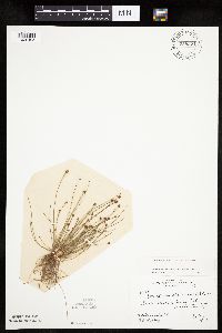 Eleocharis obtusa (Willdenow) Schultes 758321[1020405]Rosendahl, C.; et al. 51201926-09-06 United States, Minnesota, Anoka, Moore Lake;;030N;24W;23, 45.071682 -93.257896 |
MIN:Plants | 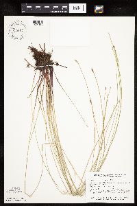 Eleocharis erythropoda Steudel 758667[1020112]Smith, Welby 73111982-08-15 United States, Minnesota, Wright, Wright County ... On the south side of U.S. Highway 12, about 1 mi. east of Howard Lake ... NW1/4 NW1/4 section 2 T118N R27W. 118N 27W 2, 45.058248 -94.042965 |
MIN:Plants | 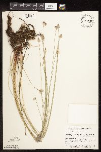 Eleocharis erythropoda Steudel 758762[1102583]Smith, Welby 65061982-06-29 United States, Minnesota, Le Sueur, Le Sueur County ... On the W side of County Highway 23, about 2 mi NE of St. Peter, in the Minnesota Valley ... T110N R26W, NE1/4 NW1/4 sec.11. 110N 26W 11, 44.348192 -93.919172 |
MIN:Plants | 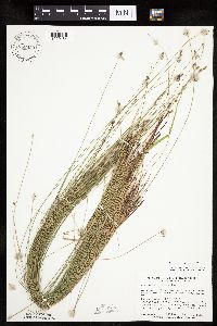 Eleocharis erythropoda Steudel 758933[1020164]Smith, Welby 73711982-08-19 United States, Minnesota, Le Sueur, Ottawa Wildlife Management Area. LeSueur County...On the W side of County Highway 23, about 2 mi NE of St. Peter in the Minnesota Valley...NE1/4 NW1/4 section 11, T 110N R 26W. 110N 26W 11, 44.348192 -93.919172 |
MIN:Plants |  Eleocharis erythropoda Steudel 759189[1020111]Smith, Welby 70361982-07-31 United States, Minnesota, Wright, Wright County ... Between Albion Lake and County Highway 6, about 4 mi. southwest of Maple Lake ... NE1/4 SW1/4 section10, T 120N R 27W. 120N 27W 10, 45.217384 -94.064131 |
MIN:Plants |  Eleocharis erythropoda Steudel 759403[1102596]Smith, Welby 64721982-06-25 United States, Minnesota, Wright, Wright County ... On the south side of U.S. Highway 12, about 1 mi. eas of Howard Lake ... NW1/4 NW1/4 section 2, T 118N R 27W. 118N 27W 2, 45.058248 -94.042965 |
MIN:Plants |  Eleocharis erythropoda Steudel 770110[1020181]Smith, Welby 86301983-08-11 United States, Minnesota, Lake of the Woods, Lake of the Woods County ... Zipple Bay State Park ... south shore of Lake of the Woods. SE1/4 SW1/4 sec 2, T 162N R 33W;Zippel Bay State Park;162N;33W;02, 48.880239 -94.861224 |
MIN:Plants |  Eleocharis erythropoda Steudel 773292[1020095]Boe, J. 12551979-08-02 United States, Minnesota, Lake of the Woods, Lake of the Woods County ... Long Point ... SW1/4 Sec. 31 R33W T164N;;164N;33W;31, 48.981194 -94.949282 |
MIN:Plants | 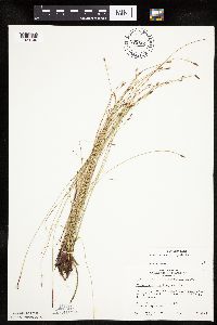 Eleocharis erythropoda Steudel 773664[1020100]Boe, J. 9921979-07-20 United States, Minnesota, Lake of the Woods, Lake of the Woods County ... On Spina Trail, 2.7 mi. southwest of Range Line.;Beltrami Island State Forest;158N;34W;11, 48.518083 -94.983787 |
MIN:Plants | 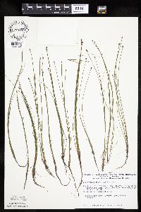 Eleocharis ovata (Roth) Roemer & Schultes 774168[1020541]Monson, Paul 56141983-07-24 United States, Minnesota, Saint Louis, Kabetogama Lake, Bald Rock Bay. NW of LaBonty's Point.;Voyageurs National Park;070N;21W;29, 48.522136 -93.058468 |
MIN:Plants |  Eleocharis obtusa (Willdenow) Schultes 778242[1020446]Converse, C. 2635A1985-08-31 United States, Minnesota, Lac Qui Parle, Lac Qui Parle County ... NE 1/4 NW 1/4 Sec. 14, T120N R45W.;Plover Prairie, The Nature Conservancy;120N;45W;14, 45.204088 -96.258256 |
MIN:Plants |  Eleocharis erythropoda Steudel 787111[1020135]Maxson, George-Ann s.n.1981-06-23 United States, Minnesota, Lake of the Woods, Lake of the Woods County ... Stony Point. Sections 2 & 3, T 165 N, R 35 W.;Northwest Angle;165N;35W;, 49.105822 -95.122912 |
MIN:Plants |  Eleocharis erythropoda Steudel 800138[1020124]Cholewa, A.; et al. 17071989-07-06 United States, Minnesota, Washington, Carpenter Nature Center. Washington Co, T26N R20W S4...at delta of north ravine;Carpenter Nature Center;026N;20W;04, 44.768807 -92.813616 |
MIN:Plants |  Eleocharis ovata (Roth) Roemer & Schultes 801101[1020532]Smith, Welby 109641985-08-01 United States, Minnesota, Beltrami, School Lake, on the N side of Hwy. 8, ca. 8 mi. E-SE of Bemidji.;;146N;32W;16, 47.461201 -94.745341 |
MIN:Plants |  Eleocharis erythropoda Steudel 805747[1020197]Almendinger, J. s.n.1988-06-27 United States, Minnesota, Washington, William O'Brien State Park. Washington County ... Greenburg Island, O'Brien State Park. Marine on St. Croix ... T32N, R19W, NE1/4 SE1/4 of section 31 ... E side of Greenburg Island; appx. 1 mi. N town. 032N 19W 31, 45.217153 -92.76414 |
MIN:Plants |  Eleocharis obtusa (Willdenow) Schultes 805748[1020445]Almendinger, J. s.n.1988-06-27 United States, Minnesota, Washington, William O'Brien State Park. Washington County ... Greenburg Island, O'Brien State Park. Marine on St. Croix. T32N R19W NE1/4 SE1/4 of section 31 ... Greenburg Island; appx. 1 mi. N town. 032N 19W 31, 45.217153 -92.76414 |
MIN:Plants |  Eleocharis ovata (Roth) Roemer & Schultes 814886[1020513]Bender, J. s.n.1986-08-08 United States, Minnesota, Washington, Belwin Outdoor Education Laboratory, Independent Pond, T28N R20W S10.;Belwin Outdoor Education Laboratory;028N;20W;10, 44.927188 -92.791852 |
MIN:Plants |  Eleocharis obtusa (Willdenow) Schultes 815201[1020444]Wheeler, Gerald 116671988-08-11 United States, Minnesota, Norman, Norman County ... Ca. 9 mi. NNE of Gary; E of Rte. 34 ... NW1/4 SW1/4 Sec. 6 T146N R43W (Bear Park Twp.);;146N;43N;06, 47.492464 -96.184947 |
MIN:Plants |  Eleocharis obtusa (Willdenow) Schultes 815644[1020417]Wheeler, Gerald 111931988-07-19 United States, Minnesota, Big Stone, Big Stone County ... Ca. 1.2 mi. NW of Barry; about 0.3 mi. E of Rte. 57 ... SE1/4 NW1/4 Sec. 8 T124N R47W.;Barry Lake Wildlife Management Area;124N;47W;08, 45.565691 -96.586118 |
MIN:Plants |  Eleocharis erythropoda Steudel 81713[1020234]Ballard, C. 26561900-08-00 United States, Minnesota, Kittson, St. Vincent, Kittson Co.;;163N;51W;, 48.945898 -97.210703 |
MIN:Plants |  Eleocharis erythropoda Steudel 81714[1020242]Frost, W. T1841892-06-00 United States, Minnesota, Meeker, Litchfield, Meeker Co.;;119N;31W;, 45.109214 -94.56847 |
MIN:Plants |  Eleocharis obtusa (Willdenow) Schultes 817549[1020418]Delaney, B. 890501989-06-29 United States, Minnesota, Isanti, Isanti County ... Site is 2 mi S-SW of Isanti, on E side of Rum River. NE1/4 NW1/4 Sec. 12, T34N, R24W;;034N;24W;12, 45.449615 -93.27591 |
MIN:Plants |  Eleocharis obtusa (Willdenow) Schultes 81809[1020384]Burglehaus, F. 5841892-08-00 United States, Minnesota, Hennepin, near Minneapolis.;;;;, 44.979965 -93.263836 |
MIN:Plants |  Eleocharis obtusa (Willdenow) Schultes 81810[1020435]Manning, Sara 5841886-08-18 United States, Minnesota, Wabasha, Mount Pleasant;;111N;13W;, 44.411481 -92.369951 |
MIN:Plants |  Eleocharis obtusa (Willdenow) Schultes 81811[1020403]Rosendahl, C. s.n.1917-10-07 United States, Minnesota, Ramsey, St. Anthony Park [neighborhood near U of M], St. Paul.;;029N;23W;, 44.992077 -93.166387 |
MIN:Plants |  Eleocharis obtusa (Willdenow) Schultes 81813[1020385]Rosendahl, C. s.n.1918-09-20 United States, Minnesota, Hennepin, east of Long Lake, Hennepin Co.;;118N;23W;, 45.022073 -93.583945 |
MIN:Plants |  Eleocharis ovata (Roth) Roemer & Schultes 81814[1020568]Butters, F. s.n.1918-09-20 United States, Minnesota, Hennepin, Margin of a pond, near Long Lake.;;N;;, 44.98888 -93.557589 |
MIN:Plants |  Eleocharis obtusa (Willdenow) Schultes 81816[1020401]Rosendahl, C. 34051916-09-18 United States, Minnesota, Ramsey, Larpenteur Ave, west of [U of M] College of Ag;;029N;23W;, 44.992077 -93.166387 |
MIN:Plants |  Eleocharis obtusa (Willdenow) Schultes 81818[1020452]Rosendahl, C.; Butters, F. 36031918-07-09 United States, Minnesota, Crow Wing, 2 miles east of Fort Ripley. Crow Wing County;;043N;32W;, 46.16607 -94.31847 |
MIN:Plants |  Eleocharis obtusa (Willdenow) Schultes 81819[1020453]Rosendahl, C.; Butters, F. 33631916-08-08 United States, Minnesota, Benton, 12 mi. N.E. of St. Cloud.;;;;, 45.720262 -94.036934 |
MIN:Plants |  Eleocharis obtusa (Willdenow) Schultes 81820[1102654]Sandberg, John s.n.1890-09-00 United States, Minnesota, Isanti, [no further data];;;;, 45.561487 -93.295181 |
MIN:Plants |  Eleocharis obtusa (Willdenow) Schultes 81821[1102671]Sandberg, John s.n.1890-08-00 United States, Minnesota, Hennepin, [no further data];;;;, 45.004579 -93.476877 |
MIN:Plants | 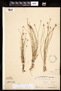 Eleocharis obtusa (Willdenow) Schultes 81822[1020390]Campbell, Jennie C.791896-07-00 United States, Minnesota, Stearns, St. Cloud;;;;, 45.55 -94.166667 |
MIN:Plants | 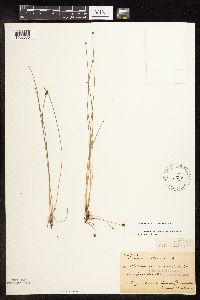 Eleocharis ovata (Roth) Roemer & Schultes 81823[1102678]MacMillan, C.; et al. MS751890-08-00 United States, Minnesota, Cass, [no further data];;;;, 46.887089 -94.095581 |
MIN:Plants | 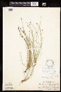 Eleocharis obtusa (Willdenow) Schultes 81825[1020402]Rosendahl, C. 2171901-09-16 United States, Minnesota, Ramsey, Merriam Park [St. Paul neighborhood at west end of Minnehaha Ave.];;029N;23W;, 44.992077 -93.166387 |
MIN:Plants | 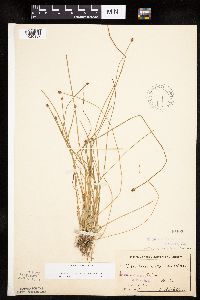 Eleocharis obtusa (Willdenow) Schultes 81826[1020387]Sheldon, Edmund S.30451892-07-00 United States, Minnesota, Mille Lacs, Milaca;;037N;27W;, 45.692047 -93.698793 |
MIN:Plants |  Eleocharis obtusa (Willdenow) Schultes 81827[1020411]Taylor, B. T15171892-08-00 United States, Minnesota, Chisago, North Branch;;035N;21W;, 45.513689 -92.960162 |
MIN:Plants |  Eleocharis obtusa (Willdenow) Schultes 81828[1020379]Ballard, C. B4591891-07-00 United States, Minnesota, Scott, Prior Lake, Scott County;;115N;21W;, 44.753605 -93.344349 |
MIN:Plants |  Eleocharis ovata (Roth) Roemer & Schultes 81864[1020542]Arthur, J.; et al. B1481886-07-22 United States, Minnesota, Saint Louis, Vermilion Lake;;;;, 47.879148 -92.351718 |
MIN:Plants |  Eleocharis ovata (Roth) Roemer & Schultes 81865[1102681]Taylor, B. S.N.1892-08-00 United States, Minnesota, Chisago, Center City.;;034N;20W;, 45.42608 -92.83619 |
MIN:Plants |  Eleocharis ovata (Roth) Roemer & Schultes 81866[1020518]Sheldon, Edmund S16341891-09-00 United States, Minnesota, Chisago, Taylors Falls.;;034N;19W;, 45.426028 -92.716274 |
MIN:Plants |  Eleocharis ovata (Roth) Roemer & Schultes 81867[1102699]Rosendahl, C.; Butters, F. 3617b1918-07-17 United States, Minnesota, Anoka, Moore Lake.;;030N;24W;, 45.080985 -93.255535 |
MIN:Plants |  Eleocharis ovata (Roth) Roemer & Schultes 81868[1020583]Rosendahl, C.; Butters, F. 36051918-07-09 United States, Minnesota, Crow Wing, 2 mi. E of Fort Ripley.;;N;;, 46.16607 -94.31847 |
MIN:Plants |  Eleocharis ovata (Roth) Roemer & Schultes 81869[1020559]Taylor, B. T16281892-08-00 United States, Minnesota, Chisago, Center City.;;034N;20W;, 45.42608 -92.83619 |
MIN:Plants |  Eleocharis erythropoda Steudel 81922[1020232]Skinner, S. 171902-06-09 United States, Minnesota, Jackson, Heron Lake. Heron Lake Region, Jackson County;;104N;37W;, 43.804688 -95.275713 |
MIN:Plants |  Eleocharis erythropoda Steudel 81941[1102584]Ballard, C. s.n.1891-06-00 United States, Minnesota, Carver, Chaska.;;116N;23W;, 44.848169 -93.581063 |
MIN:Plants |  Eleocharis erythropoda Steudel 81942[1020127]Manning, Sara L8861886-06-30 United States, Minnesota, Wabasha, Lake City.;;111N;12W;, 44.4081 -92.252454 |
MIN:Plants |  Eleocharis erythropoda Steudel 81945[1102597]Rosendahl, C.; Butters, F. 36311918-07-17 United States, Minnesota, Anoka, near Moore Lake. Anoka County;;030N;24W;, 45.080985 -93.255535 |
MIN:Plants |  Eleocharis erythropoda Steudel 81946[1020209]Rosendahl, C. 36321918-07-17 United States, Minnesota, Anoka, near Moore Lake. Anoka County;;030N;24W;, 45.080985 -93.255535 |
MIN:Plants |  Eleocharis erythropoda Steudel 81947[1020228]Rosendahl, C.; Butters, F. 32491916-06-14 United States, Minnesota, Blue Earth, East of Mankato.;;108N;26W;, 44.152568 -93.948763 |
MIN:Plants |  Eleocharis erythropoda Steudel 81948[1020231]Rosendahl, C.; Butters, F. 32501916-06-14 United States, Minnesota, Blue Earth, S.E. of Mankato.;;108N;26W;, 44.152568 -93.948763 |
MIN:Plants |  Eleocharis erythropoda Steudel 81949[1020229]Rosendahl, C.; Butters, F. 32481916-06-14 United States, Minnesota, Blue Earth, 5 mi. east of Mankato.;;108N;26W;, 44.152568 -93.948763 |
MIN:Plants |  Eleocharis erythropoda Steudel 81950[1020168]Rosendahl, C.; Butters, F. 29341915-06-19 United States, Minnesota, Fillmore, About 2 mi. SE of Chatfield. Fillmore County;;104N;11W;, 43.803917 -92.14917 |
MIN:Plants |  Eleocharis erythropoda Steudel 81951[1020202]Rosendahl, C.; Butters, F. 28891915-06-14 United States, Minnesota, Hennepin, Minnesota River Valley, S.W. Hennepin County;;;;, 44.905162 -93.166462 |
MIN:Plants | Eleocharis erythropoda Steudel 81952[]Rosendahl, C.; Butters, F. 28901915-06-14 United States, Minnesota, Hennepin, SW Hennepin Co.;;;;, 45.004579 -93.476877 |
MIN:Plants |  Eleocharis erythropoda Steudel 81953[1020233]Rosendahl, C.; Butters, F. 39211920-06-26 United States, Minnesota, Fillmore, South Fork of the Root River, Vickerman's Spring, near Amherst. Fillmore County;Dorer Memorial Hardwood State Forest;102N;09W;, 43.630572 -91.909924 |
Google Map
Google Maps is a web mapping service provided by Google that features a map that users can pan (by dragging the mouse) and zoom (by using the mouse wheel). Collection points are displayed as colored markers that when clicked on, displays the full information for that collection. When multiple species are queried (separated by semi-colons), different colored markers denote each individual species.