University of Minnesota
http://www.umn.edu/
612-625-5000
http://www.umn.edu/
612-625-5000
Minnesota Biodiversity Atlas
Bell Museum
Dataset: MIN-Plants
Taxa: Myrsinaceae
Search Criteria: excluding cultivated/captive occurrences
Bell Museum plants | |
 MIN:Plants |  Lysimachia terrestris (L.) Britton, Sterns & Poggenburg 419297[1144541]Briggs, John De Q.; Briggs, Marjorie 541945-08-03 United States, Minnesota, Cook, Sawbill Lake. T62N, R04W.;Boundary Waters Canoe Area Wilderness / Superior National Forest;062N;04W;, 47.8457962 -90.8298816 |
MIN:Plants |  Lysimachia terrestris (L.) Britton, Sterns & Poggenburg 419683[1144546]Lakela, Olga 112221950-08-08 United States, Minnesota, Saint Louis, Savanna River at Floodwood.;;051N;20W;, 46.8958426 -92.8691055 |
MIN:Plants |  Lysimachia terrestris (L.) Britton, Sterns & Poggenburg 420679[1144548]Lakela, Olga 109501950-07-29 United States, Minnesota, Saint Louis, Swan River Road, near the Duluth Airport, Duluth.;;N;;, 46.830041 -92.183098 |
MIN:Plants |  Lysimachia terrestris (L.) Britton, Sterns & Poggenburg 420902[1144543]Lakela, Olga 115661950-08-21 United States, Minnesota, Saint Louis, Iron River at Curtain Falls, Crooked Lake.;Boundary Waters Canoe Area Wilderness / Superior National Forest;066N;12W;, 48.1867867 -91.8699675 |
MIN:Plants |  Lysimachia terrestris (L.) Britton, Sterns & Poggenburg 421688[1144590]Ahlgren, Clifford 11381950-08-22 United States, Minnesota, Saint Louis, 1/4 mi. SW of Curtain Falls, Crooked Lake.;Boundary Waters Canoe Area Wilderness / Superior National Forest;066N;12W;, 48.1867867 -91.8699675 |
MIN:Plants |  Lysimachia terrestris (L.) Britton, Sterns & Poggenburg 421689[1144558]Ahlgren, Clifford 8791978-07-18 Canada, Ontario, Rainy River, NE shoreline on Moose Bay, Quetico Park.;;;;, 48.709031 -91.149182 |
MIN:Plants |  Lysimachia terrestris (L.) Britton, Sterns & Poggenburg 421690[1144603]Ahlgren, Clifford 11131950-08-22 United States, Minnesota, Saint Louis, 1/8 mi. below Curtain Falls, Crooked Lake.;Boundary Waters Canoe Area Wilderness / Superior National Forest;066N;12W;, 48.1867867 -91.8699675 |
MIN:Plants |  Lysimachia terrestris (L.) Britton, Sterns & Poggenburg 421760[1144604]Ahlgren, Clifford 9791950-08-16 United States, Minnesota, Lake, Quetico-Superior Wilderness Research Center, Lake Co. QSWRC forest plantation. Sec. 9, T64N, R10W.;Boundary Waters Canoe Area Wilderness / Superior National Forest;064N;10W;09, 48.0316509 -91.6188616 |
MIN:Plants | 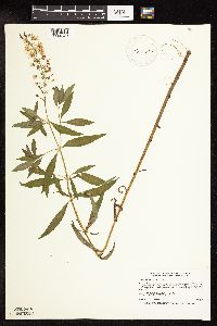 Lysimachia terrestris (L.) Britton, Sterns & Poggenburg 429543[1144579]Smith, Welby 194491991-07-15 United States, Minnesota, Aitkin, Savanna Portage State Park. Aitkin Co.; Savanna Portage State Park, along path around the north side of Loon Lake; Aitkin Co.; Savanna Portage State Park, along path around the north side of Loon Lake; T 50N R 23W SE1/4 of SE1/4 of Sec 12. 050N 23W 12, 46.8280563 -93.191391 |
MIN:Plants | 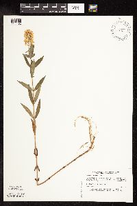 Lysimachia terrestris (L.) Britton, Sterns & Poggenburg 439556[1144492]Myhre, K. 41351993-07-12 United States, Minnesota, Pine, Pine Co. Located 1.5 mi SW of Upper Pine Lake; T43N R21W NW1/4 of SE1/4 of Sec 31;;043N;21W;31, 46.1656546 -93.043334 |
MIN:Plants | 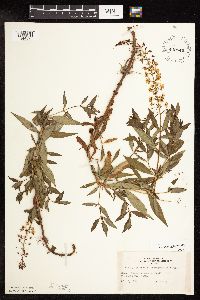 Lysimachia terrestris (L.) Britton, Sterns & Poggenburg 442849[1144596]Lakela, Olga 129231951-07-09 United States, Minnesota, Saint Louis, Namakan Lake at Kettle Falls.;Voyageurs National Park;070N;18W;, 48.5214443 -92.6653567 |
MIN:Plants | 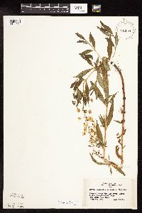 Lysimachia terrestris (L.) Britton, Sterns & Poggenburg 442894[1144601]Lakela, Olga 133751951-07-18 United States, Minnesota, Saint Louis, Shore of Moose Bay, Ash River, ca. 1 mi. from Frontier Lodge.;Voyageurs National Park;069N;19W;33, 48.4185836 -92.7779033 |
MIN:Plants |  Lysimachia terrestris (L.) Britton, Sterns & Poggenburg 443332[1144600]Lakela, Olga 128221951-06-28 United States, Minnesota, Saint Louis, Little Vermillion River, "Loon Flats", Minnesota-Ontario boundary.;Boundary Waters Canoe Area Wilderness / Superior National Forest;N;;, 48.277162 -92.412906 |
MIN:Plants |  Lysimachia terrestris (L.) Britton, Sterns & Poggenburg 444406[1144499]Smith, Welby 196551991-07-17 United States, Minnesota, Itasca, Scenic State Park. Itasca Co.; Scenic State Park, about 4.5 miles southeast of Bigfork; Coon Lake (west side); Itasca Co.; Scenic State Park, about 4.5 miles southeast of Bigfork; Coon Lake (west side); T 60N R 25W SE1/4 of NW1/4 of Sec 6. 060N 25W 6, 47.7166672 -93.5716629 |
MIN:Plants |  Lysimachia terrestris (L.) Britton, Sterns & Poggenburg 445086[1144535]Moore, John; Huff, N. 197431947-08-08 United States, Minnesota, Morrison, Along the Swan River, 5 mi. SW of Little Falls.;;N;;, 45.927768 -94.437814 |
MIN:Plants |  Lysimachia terrestris (L.) Britton, Sterns & Poggenburg 446360[1144611]Moore, John; et al. 187471946-07-25 United States, Minnesota, Ramsey, Ramsey County...South side of Snail Lake.;Snail Lake Vadnais Lake County Park;030N;23W;24, 45.0720209 -93.1165486 |
MIN:Plants |  Lysimachia terrestris (L.) Britton, Sterns & Poggenburg 446730[1144566]Moore, John; Huff, N. 178301945-07-24 United States, Minnesota, Morrison, Along the rr right of way 1 1/2 mi N of Lilltle [Little] Falls.;;;;, 46.002274 -94.369444 |
MIN:Plants |  Lysimachia terrestris (L.) Britton, Sterns & Poggenburg 455312[1144495]Boe, J.; Butler, Cindy 980623101998-06-23 United States, Minnesota, Aitkin, Aitkin Co.; Little Prairie Lake in Savanna State Forest east of Savanna Portage State Park; T50N R22W E1/2 of Sec 15;Savanna State Forest;050N;22W;15, 46.8170082 -93.113765 |
MIN:Plants |  Lysimachia terrestris (L.) Britton, Sterns & Poggenburg 457990[1144595]Garrison, O. 1880-00-00 United States, Minnesota, Upper Mississippi.;;;;, 47.218056 -95.207222 |
MIN:Plants |  Lysimachia terrestris (L.) Britton, Sterns & Poggenburg 462586[1144536]Lakela, Olga 145481952-07-08 United States, Minnesota, Saint Louis, Shore of Fox Island, Rainy Lake.;;071N;21W;, 48.624469 -92.960793 |
MIN:Plants | 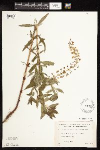 Lysimachia terrestris (L.) Britton, Sterns & Poggenburg 463005[1144538]Lakela, Olga 147661952-07-10 United States, Minnesota, Saint Louis, Shore of Rainy Lake, rocky point of Cranberry Bay area.;Voyageurs National Park;071N;21W;, 48.6062571 -93.0240378 |
MIN:Plants | 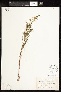 Lysimachia terrestris (L.) Britton, Sterns & Poggenburg 463097[1144539]Lakela, Olga 143391952-06-21 United States, Minnesota, Saint Louis, Sand Point Lake, S of Namakan Narrows.;Voyageurs National Park;N;;, 48.430739 -92.490154 |
MIN:Plants | 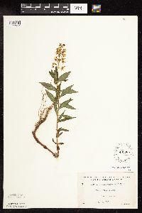 Lysimachia terrestris (L.) Britton, Sterns & Poggenburg 463385[1144537]Lakela, Olga 148781952-07-13 United States, Minnesota, Saint Louis, Pine Island, Kabetogama Lake.;Voyageurs National Park;N;;, 48.448524 -92.930707 |
MIN:Plants | 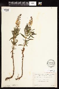 Lysimachia terrestris (L.) Britton, Sterns & Poggenburg 492938[1144620]Lakela, Olga 162261953-07-18 United States, Minnesota, Saint Louis, Shore of Vermilion Lake at Treasure Island Resort.;;;;, 47.900373 -92.555366 |
MIN:Plants |  Lysimachia terrestris (L.) Britton, Sterns & Poggenburg 508585[1144506]Myhre, K. 41031993-07-09 United States, Minnesota, Pine, Pine Co. Located along the NW shore of Pickerel Lake; T45N R17W SE1/4 of SW1/4 of sec 1;Nemadji State Forest;045N;17W;1, 46.4104162 -92.4355809 |
MIN:Plants |  Lysimachia terrestris (L.) Britton, Sterns & Poggenburg 519164[1144497]Lobien, D. s.n.1993-07-07 United States, Minnesota, Washington, About one mile and a half east of White Bear Lake in Washington Co.; NW 1/4 SEC.26, NE 1/4 SEc.27 T30N, R21W;;030N;21W;, 45.0796523 -92.9239 |
MIN:Plants |  Lysimachia terrestris (L.) Britton, Sterns & Poggenburg 519166[1144491]Lobien, D. s.n.1993-07-07 United States, Minnesota, Washington, About one mile and a half east of White Bear Lake in Washington Co.; NW 1/4 SEC.26, NE1/4 SEC.27 T30N, R21W;;030N;21W;, 45.0796523 -92.9239 |
MIN:Plants |  Lysimachia terrestris (L.) Britton, Sterns & Poggenburg 524413[1144591]Benner, J. s.n.1947-07-08 United States, Minnesota, Chisago, St. Croix, Minnesota side of the river, 5 mi. upstream.;;N;;, 45.346629 -92.702663 |
MIN:Plants |  Lysimachia terrestris (L.) Britton, Sterns & Poggenburg 525673[1144623]Lakela, Olga 188061955-07-12 United States, Minnesota, Saint Louis, Shore of small lake SE of Gilbert.;;;;, 47.475228 -92.441917 |
MIN:Plants |  Lysimachia terrestris (L.) Britton, Sterns & Poggenburg 525996[1144624]Lakela, Olga 190441955-08-03 United States, Minnesota, Saint Louis, Shore of the outlet river of Johnson's Lake to Namakan Lake.;;;;, 48.402528 -92.674575 |
MIN:Plants |  Lysimachia terrestris (L.) Britton, Sterns & Poggenburg 527184[1144569]Lakela, Olga 178271954-07-12 United States, Minnesota, Saint Louis, St. Louis County...Trout River, above the falls, between Trout and Vermilion Lakes.;Boundary Waters Canoe Area Wilderness / Superior National Forest;063N;16W;24, 47.9243525 -92.3193738 |
MIN:Plants |  Lysimachia terrestris (L.) Britton, Sterns & Poggenburg 527272[1144615]Lakela, Olga 181401954-08-13 United States, Minnesota, Saint Louis, Shore of Saturday Bay of Crokked Lake.;Boundary Waters Canoe Area Wilderness / Superior National Forest;066;12W;, 48.1867867 -91.8699675 |
MIN:Plants | 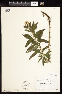 Lysimachia terrestris (L.) Britton, Sterns & Poggenburg 532403[1144616]Lakela, Olga 210391956-08-29 United States, Minnesota, Saint Louis, St. Louis County...Portage Creek bed to Dark Lake from Iron Lake.;Boundary Waters Canoe Area Wilderness / Superior National Forest;066N;13W;11, 48.2168365 -91.9613992 |
MIN:Plants | 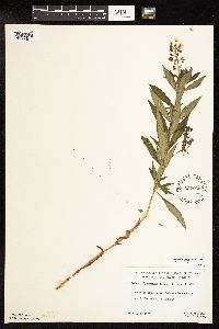 Lysimachia terrestris (L.) Britton, Sterns & Poggenburg 532935[1144617]Lakela, Olga; et al. 206651956-08-07 United States, Minnesota, Lake, St. Louis County...river between Moose Camp and Bullet Lakes, N of Ely [actually in Lake Co.];Boundary Waters Canoe Area Wilderness / Superior National Forest;065N;11W;18, 48.1152216 -91.7878959 |
MIN:Plants | 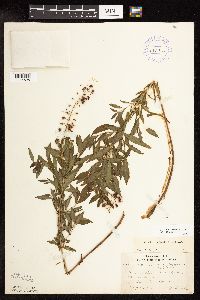 Lysimachia terrestris (L.) Britton, Sterns & Poggenburg 53297[1144598]Lakela, Olga 66211946-08-11 United States, Minnesota, Saint Louis, Burntside Lake, N arm.;Superior National Forest;064N;13W;00, 48.0201934 -91.9900502 |
MIN:Plants | 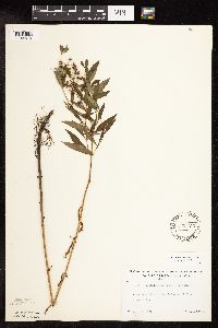 Lysimachia terrestris (L.) Britton, Sterns & Poggenburg 543450[1144516]Lakela, Olga 221241957-08-19 United States, Minnesota, Lake, Shore of South Kawishiwi River S of Ely.;;N;;, 47.847183 -91.798537 |
MIN:Plants |  Lysimachia terrestris (L.) Britton, Sterns & Poggenburg 543547[1144514]Lakela, Olga 219771957-08-14 United States, Minnesota, Lake, Shore of Greenwood Lake N of Two Harbors, Hwy #2.;;N;;, 47.518701 -91.63254 |
MIN:Plants |  Lysimachia terrestris (L.) Britton, Sterns & Poggenburg 543633[1144515]Lakela, Olga; Davidson, Donald 215771957-07-25 United States, Minnesota, Lake, Phoebe River, Tomahawk Trail, eastern Lake Co.;Boundary Waters Canoe Area Wilderness / Superior National Forest;063N;06W;00, 47.9332192 -91.0879206 |
MIN:Plants |  Lysimachia terrestris (L.) Britton, Sterns & Poggenburg 568833[1144521]Moore, John 252981960-09-21 United States, Minnesota, Anoka, W shore of Fish Lake.;Cedar Creek National History Area;034N;23W;, 45.40411 -93.172056 |
MIN:Plants |  Lysimachia terrestris (L.) Britton, Sterns & Poggenburg 568963[1144612]Moore, John; Archer, A.; Bray, J. 251501960-07-14 United States, Minnesota, Anoka, Anoka County...Across the road, N shore of Fish Lake.;Cedar Creek National History Area;034N;23W;26, 45.4069008 -93.1731469 |
MIN:Plants |  Lysimachia terrestris (L.) Britton, Sterns & Poggenburg 576806[1144634]Isaak, Daniel 371960-07-06 United States, Minnesota, Isanti, Horseshoe Lake, Sec 2 and 11, T34N, R22W.;;034N;22W;, 45.4273233 -93.0810767 |
MIN:Plants |  Lysimachia terrestris (L.) Britton, Sterns & Poggenburg 583387[1144594]Kellner, H. 4241956-07-31 United States, Minnesota, Lake, Along the shore of Lake Superior, Shovel Point.;North Shore / Tettegouche State Park;056N;07W;14, 47.3409299 -91.1921604 |
MIN:Plants |  Lysimachia terrestris (L.) Britton, Sterns & Poggenburg 603640[1144613]Moore, John; Moore, Marjorie 269541966-07-22 United States, Minnesota, Anoka, W shore of Fish Lake, Cedar Creek Natural History Area.;Cedar Creek National History Area;034N;23W;, 45.405014 -93.177549 |
MIN:Plants |  Lysimachia terrestris (L.) Britton, Sterns & Poggenburg 607458[1144545]Ownbey, Gerald; Hsi, Yu-tseng [Eugene] 42091968-08-19 United States, Minnesota, Aitkin, Aitkin Co. 1 mi. W of McGregor.;;048N;24W;, 46.6377977 -93.3801641 |
MIN:Plants |  Lysimachia terrestris (L.) Britton, Sterns & Poggenburg 616837[1144547]Moore, John; Moore, Marjorie 4671969-08-27 United States, Minnesota, Crow Wing, Crow wing Natural Area;044N;28W;29, 46.2651419 -93.9044982 |
MIN:Plants |  Lysimachia terrestris (L.) Britton, Sterns & Poggenburg 681739[1144534]Wheeler, Gerald 11871977-07-08 United States, Minnesota, Beltrami, Ca. 12 mi. N of the Waskish Airport on Hwy. 72.;Red Lake Peatland Scientific Natural Area;156N;30W;7, 48.3450384 -94.5436287 |
MIN:Plants |  Lysimachia terrestris (L.) Britton, Sterns & Poggenburg 687736[1144550]Wheeler, Gerald; Glaser, Paul 21831977-07-21 United States, Minnesota, Itasca, SE1/4 NW1/4 Sec. 1, T56N, R26W, Ca. 8.5 mi. N-NW of Grand Rapids.;;056N;26W;1, 47.3627849 -93.5872183 |
MIN:Plants |  Lysimachia terrestris (L.) Britton, Sterns & Poggenburg 687738[1144551]Wheeler, Gerald 21851977-07-21 United States, Minnesota, Itasca, NE1/4 SW1/4 Sec. 10, T55N, R26W; ca. 4.5 mi. W-NW of Grand Rapids. On th NE shore of Blackwater Lake.;;055N;26W;10, 47.260439 -93.6294974 |
MIN:Plants | 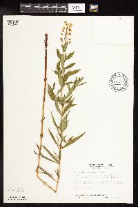 Lysimachia terrestris (L.) Britton, Sterns & Poggenburg 687781[1144599]Wheeler, Gerald; Glaser, Paul 22251977-07-23 United States, Minnesota, Itasca, Ca. 4.5 mi. W-NW of Grand Rapids. On the NE shore of Blackwater Lake.;;055N;26W;10, 47.260439 -93.6294974 |
MIN:Plants | 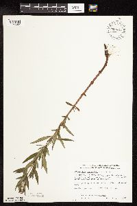 Lysimachia terrestris (L.) Britton, Sterns & Poggenburg 698372[1144587]Wheeler, Gerald; Glaser, Paul 31731978-07-05 United States, Minnesota, Beltrami, SE1/4 NE1/4 Sec. 1, T156N, R31W; ca. 14.5 mi. N of the Washkish Airport on Rte. 72, ca. 0.1 mi. W of the road. Site 35.;Red Lake Peatland Scientific Natural Area;156N;31W;1, 48.3599671 -94.564698 |
MIN:Plants | 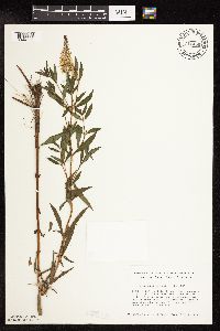 Lysimachia terrestris (L.) Britton, Sterns & Poggenburg 711456[1144586]Smith, Welby 10891979-07-06 United States, Minnesota, Anoka, Anoka Co. T30N, R24W; within the municipal boundaries of Fridley. 'West Moore Lake Dunes Natural Area'. Near edge of Moo Anoka Co. T30N, R24W; within the municipal boundaries of Fridley. 'West Moore Lake Dunes Natural Area'. Near edge of Moore Lake.. 030N 24W , 45.0809847 -93.2555346 |
MIN:Plants | 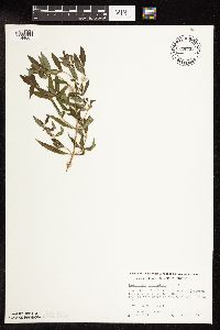 Lysimachia terrestris (L.) Britton, Sterns & Poggenburg 728433[1144607]Wheeler, Gerald 53911980-07-18 United States, Minnesota, Ramsey, Ramsey Co.; Roseville. Little Lake Josephine (between Lake Josephine and Lake Owasso). N side of lake. T29N, R23W, Sec2.;;029N;23W;2, 45.0282825 -93.1365457 |
MIN:Plants |  Lysimachia terrestris (L.) Britton, Sterns & Poggenburg 728642[1144606]Wheeler, Gerald 53571980-07-18 United States, Minnesota, Ramsey, Ramsey Co.; Roseville. Little Lake Josephine (between Lake Josephine and Lake Owasso). E side of lake. T29N, R23W, Sec2.;;029N;23W;2, 45.0282825 -93.1365457 |
MIN:Plants |  Lysimachia terrestris (L.) Britton, Sterns & Poggenburg 729544[1144608]Cutler, S. 1591980-07-17 United States, Minnesota, Pine, Pine Co. St. Croix Natural Area: 21 mi E of Hinckley. NW1/4 NW1/4 Sec 32, T41N, R17W.;Saint Croix State Park;041N;17W;32, 45.9906767 -92.5191695 |
MIN:Plants |  Lysimachia terrestris (L.) Britton, Sterns & Poggenburg 738112[1144524]Pollan, S.; et al. 1041978-06-28 United States, Minnesota, Saint Louis, St. Louis Co. ... R15W, T48N, Sec 11 & 2. Mud Lake. St. Louis R. Estuary, Waterfront Trail Area.;;048N;15W;, 46.6570112 -92.257257 |
MIN:Plants |  Lysimachia terrestris (L.) Britton, Sterns & Poggenburg 739419[1144523]Tendrup, L. 3031975-07-25 United States, Minnesota, Saint Louis, Near St. Louis River, Duluth. (T49N, R14W, S18);;049N;14W;18, 46.7278308 -92.1638988 |
MIN:Plants |  Lysimachia terrestris (L.) Britton, Sterns & Poggenburg 744982[1144553]Smith, Welby 47421981-07-10 United States, Minnesota, Sherburne, At the NW tip of Rice Lake, about 3 mi due E of the jcn of Co. Hwys 5 and 9. SE1/4 NE1/4 Sec27, T35N, R27W. Area adjacen At the NW tip of Rice Lake, about 3 mi due E of the jcn of Co. Hwys 5 and 9. SE1/4 NE1/4 Sec27, T35N, R27W. Area adjacent to Rice Lake.. 035N 27W 27, 45.4940366 -93.6851044 |
MIN:Plants |  Lysimachia terrestris (L.) Britton, Sterns & Poggenburg 763577[1144528]Lugger, O. 1900-00-00 United States, Minnesota, Washington, White Bear Lake;;030N;21W;, 45.0796523 -92.9239 |
MIN:Plants |  Lysimachia terrestris (L.) Britton, Sterns & Poggenburg 764874[1144610]Haig, Vincent s.n. United States, Minnesota, Blue Earth, Mankato;;N;;, 44.163578 -93.9994 |
MIN:Plants |  Lysimachia terrestris (L.) Britton, Sterns & Poggenburg 772570[1144609]Boe, J. 13881979-08-08 United States, Minnesota, Lake of the Woods, Near Hwy 72. 2.1 mi N of co. line. W1/2 Sec19, R30W, T157N.;;157N;30W;19, 48.4035221 -94.5485174 |
MIN:Plants |  Lysimachia terrestris (L.) Britton, Sterns & Poggenburg 774123[1144526]Monson, Paul 55581983-07-20 United States, Minnesota, Saint Louis, R19W, T69N, SW1/4, SE1/4, S1; Kabetogama peninsula at Squaw Narrows.;Voyageurs National Park;069N;19W;1, 48.4913399 -92.7116119 |
MIN:Plants |  Lysimachia terrestris (L.) Britton, Sterns & Poggenburg 774485[1144626]Monson, Paul 56901983-07-30 United States, Minnesota, Saint Louis, Voyageurs National Park. R18W, T68N, SW1/4 S4; Net Lake. At N end.;Voyageurs National Park;068N;18W;4, 48.4046102 -92.6614047 |
MIN:Plants |  Lysimachia terrestris (L.) Britton, Sterns & Poggenburg 780369[1144580]Ownbey, Gerald 70531985-07-18 United States, Minnesota, Aitkin, Aitkin County...T47N, R25W, Sec 36, NW1/4 of the NE1/4. Just NE of Dam Lake, Kimberly Twp.;;047N;25W;36, 46.5124149 -93.4426258, 373m |
MIN:Plants |  Lysimachia terrestris (L.) Britton, Sterns & Poggenburg 795459[1144637]Cholewa, A.; et al. 13671987-06-18 United States, Minnesota, Aitkin, Ca 10 airmiles ESE of Aitkin, ca 1 mi E of Dam Lake; At N end of bog.;;047N;25W;36, 46.5188889 -93.4375 |
MIN:Plants |  Lysimachia terrestris (L.) Britton, Sterns & Poggenburg 796577[1144576]Sather, Nancy 87-0391987-07-29 United States, Minnesota, Itasca, Chippewa National Forest. Itasca County...Clustered Bur Reed Bog. T57N R25W Sec. 18 SW1/4. NE of Pughole Lake and W of USFS 2144.14 mi. N of Grand Rapids. 057N 25W 18, 47.4158333 -93.5661111 |
MIN:Plants |  Lysimachia terrestris (L.) Britton, Sterns & Poggenburg 804509[1144552]Smith, Welby 119721986-07-02 United States, Minnesota, Sherburne, Sherburne National Wildlife Refuge. Sherburne County...Sherburne National Wildlife Refuge, about 2 1/2 mi SE of Santiago. Along the St. Francis River. SW1/4 NW1/4 Sec23, T35N, R28W. 035N 28W 23, 45.5075 -93.7938889 |
MIN:Plants |  Lysimachia terrestris (L.) Britton, Sterns & Poggenburg 807169[1144533]Dorio, J. 911977-06-16 United States, Minnesota, Morrison, Co.: Morrison ... Sandhill Crane Meadow.;Crane Meadows National Wildlife Refuge;039N;31W;, 45.933087 -94.250094 |
MIN:Plants |  Lysimachia terrestris (L.) Britton, Sterns & Poggenburg 816658[1144505]Welling, C. 040A1990-07-02 United States, Minnesota, Ramsey, Wetland immediately N of St. hwy 96 and 0.6 km E of hwy 61, Sec. 12 of White Bear township. Ramsey Co.;;030N;22W;12, 45.1010813 -92.99472 |
MIN:Plants |  Lysimachia terrestris (L.) Britton, Sterns & Poggenburg 817405[1144564]Delaney, B. 890271989-06-16 United States, Minnesota, Isanti, Mat near margin of small "bog" lake, 4 mi W of Grandy; NE1/4 SW1/4 Sec. 36 T37N R24W;;037N;24W;36, 45.6516445 -93.2758274 |
MIN:Plants |  Lysimachia terrestris (L.) Britton, Sterns & Poggenburg 818195[1144504]Engels, A.; et al. s.n.1991-08-26 United States, Minnesota, Aitkin, Aitkin Co, T50N R23W S13 ne1/4sw1/4. Near Savanna Portage State Park on road to Remote Lake.;Savanna State Forest;050N;23W;13, 46.8170976 -93.2006559 |
MIN:Plants |  Lysimachia terrestris (L.) Britton, Sterns & Poggenburg 829298[1144507]Myhre, K. 22671992-06-18 United States, Minnesota, Cass, Cass Co. Located 1 mi E of Wabedo Lake; on the W end of Brackett Lake; T140N R28W NW1/4 of SW1/4 of Sec 25;;140N;28W;25, 46.9127922 -94.1639891 |
MIN:Plants |  Lysimachia terrestris (L.) Britton, Sterns & Poggenburg 830978[1144494]Cholewa, A. 20671992-07-00 United States, Minnesota, Aitkin, Aitkin Co. Hwy.169, ca. 1/2 mi S of Soo Line Trail. Abandoned peat mine. T50N R26W S125 NE1/4 SE1/4.;Hill River State Forest;050N;26W;15, 46.8188352 -93.6246996 |
MIN:Plants |  Lysimachia terrestris (L.) Britton, Sterns & Poggenburg 832088[1144522]Sutton, S. s.n.1981-07-11 United States, Minnesota, Saint Louis, County: St. Louis...portage area between Low and Bass Lakes...R-12W T-63N Sec.2;Superior National Forest;063N;12W;02, 47.9692 -91.83165, 411m |
MIN:Plants |  Lysimachia terrestris (L.) Britton, Sterns & Poggenburg 833639[1144577]Smith, Welby 142881988-06-20 United States, Minnesota, Washington, Washington Co. On the S side of Egg Lake in Hugo. SW1/4 SE1/4 sec 20, T31N R21W;;031N;21W;20, 45.1369438 -92.9852753 |
MIN:Plants |  Lysimachia terrestris (L.) Britton, Sterns & Poggenburg 833668[1144578]Smith, Welby 142701988-06-20 United States, Minnesota, Washington, Washington Co. At the S end of Oneka Lake, about 2 mi NE Hugo. SW1/4 SE1/4 sec.9, T31N R21W;;031N;21W;9, 45.1833344 -92.9694443 |
MIN:Plants |  Lysimachia terrestris (L.) Britton, Sterns & Poggenburg 836297[1144496]Cholewa, A. 23921995-07-28 United States, Minnesota, Aitkin, Aitkin Co. Savanna Portage State Park, about 17 mi NE of McGregor, NW end of Wolf Lake, T50N R22W S5 NW1/4 of NW1/4.;Savanna Portage State Park;050N;22W;5, 46.8460174 -93.1549185 |
MIN:Plants |  Lysimachia terrestris (L.) Britton, Sterns & Poggenburg 836378[1144493]Smith, Welby 173571990-07-18 United States, Minnesota, Morrison, On the E side of Luzon Road; Goose Pond. UTM: 389600E 5108500N. NW1/4 of NW1/4 of section;Camp Ripley Military Reservation;131N;30W;35, 46.1211439 -94.4288886 |
MIN:Plants |  Lysimachia terrestris (L.) Britton, Sterns & Poggenburg 509047[1144498]Swanson, Gary 22342001-10-05 United States, Minnesota, Sherburne, Sherburne National Wildlife Refuge ... SWNE 1-34-27 ... Bog 5;Sherburne National Wildlife Refuge;034N;27W;01, 45.4652089 -93.6436716 |
MIN:Plants |  Lysimachia terrestris (L.) Britton, Sterns & Poggenburg 454376[1144502]Myhre, K. 68951997-07-14 United States, Minnesota, Lake, Superior National Forest. Lake County ... Birch Lake. Located idrectly northeast of the town of Babbitt. Plants occur along the deep bay northwest of River Point Resort ... T 61N R 11W NW1/4 of NW1/4 of Sec 5.. 061N 11W 5, 47.7989001 -91.7586028 |
MIN:Plants |  Lysimachia terrestris (L.) Britton, Sterns & Poggenburg 490769[1188942]Garton, C. 19501952-07-29 Canada, Ontario, Thunder Bay, Thunder Bay District...High Falls, Pigeon River, Stuart Location. |
MIN:Plants |  Lysimachia terrestris (L.) Britton, Sterns & Poggenburg 909709[1144508]Lee, Michael MDL44462007-07-11 United States, Minnesota, Wadena, Wadena County...Along the Crow Wing River ~1/4 mile downstream from the mouth of Beaver Creek, 3.5 miles southeast of Nimrod...T136N R33W NW1/4 of SE/4 sec. 10...UTM: 5163115N 359882E. 136N 33W 10, 46.608193 -94.8326111 |
MIN:Plants |  Lysimachia terrestris (L.) Britton, Sterns & Poggenburg 491200[1144503]Capistrant, A. AMC11911998-07-16 United States, Minnesota, Washington, Washington Co, T30N R21W S22;;030N;21W;22, 45.0722174 -92.9138983 |
MIN:Plants |  Lysimachia terrestris (L.) Britton, Sterns & Poggenburg 575222[1188940]Garton, C. 86481961-07-07 Canada, Ontario, Rainy River, Rainy River District...Rainy R, 4-1/2 mi. below Rainy R. Town, Wildland Reserve. |
MIN:Plants |  Lysimachia terrestris (L.) Britton, Sterns & Poggenburg 680209[1158335]Coffin, Barbara 3891976-07-09 United States, Wisconsin, Bayfield, Presque Isle Point, Stockton Island;Apostle Islands National Lakeshore;;;, 46.920639 -90.548142 |
MIN:Plants |  Lysimachia terrestris (L.) Britton, Sterns & Poggenburg 828324[1158336]Benner, F.; et al. s.n.1937-07-13 United States, Wisconsin, Polk, 7 mi. N. of St. Croix Falls;Saint Croix National Riverway;;;, 45.481172 -92.687024 |
MIN:Plants |  Lysimachia terrestris (L.) Britton, Sterns & Poggenburg 923768[1144555]Anderson, Derek 13022009-08-03 United States, Minnesota, Mower, Hormel Nature Center. Northeast side of city of Austin. NWNW of section;<No data>;103N;17W;31, 43.6858517 -92.9269031 |
MIN:Plants |  Lysimachia terrestris (L.) Britton, Sterns & Poggenburg 924480[1144554]Lee, Michael MDL34892003-07-22 United States, Minnesota, Todd, Southeast of Big Lake, 4 miles west-southwest of Cushing, 8 miles northwest of Randall. SW1/4 of NW1/4 of SW1/4 of section.;Ruff-Nik Wildife Area;131N;32W;25, 46.1295449 -94.6582389 |
MIN:Plants |  Lysimachia terrestris (L.) Britton, Sterns & Poggenburg 929759[1144583]Smith, Welby 161051989-08-13 United States, Minnesota, Cook, SE end of Ranger Lake. NW1/4 of SE1/4 of section;Boundary Waters Canoe Area Wilderness / Superior National Forest;063N;04W;03, 47.9682742 -90.8188071 |
MIN:Plants |  Lysimachia terrestris (L.) Britton, Sterns & Poggenburg 930102[1144584]Smith, Welby 16075A1989-08-03 United States, Minnesota, Benton, Bibles Wildlife Management Area, about 5.5 miles SE of Foley. T36N R28W SW1/4 of NW1/4 of section 15, 45.6125 -93.820833 |
MIN:Plants |  Lysimachia terrestris (L.) Britton, Sterns & Poggenburg 930667[1144509]Gerdes, Lynden B.; Smith, Welby R. 60572010-06-28 United States, Minnesota, Cook, Skipper Lake. East end of lake at eastern end of middle bay. SWNWNW of section;Superior National Forest;064N;02W;11, 48.0463889 -90.5558333 |
MIN:Plants |  Lysimachia terrestris (L.) Britton, Sterns & Poggenburg 937623[1144585]Gerdes, Lynden B.; Bach, Melissa J. 65772012-06-26 United States, Minnesota, Lake, North Kawishiwi River. Approximately 13.24 miles east of Ely, MN and 0.58 miles southwest of the portage landing between Triangle Lake and the river.;Boundary Waters Canoe Area Wilderness / Superior National Forest;063N;10W;26, 47.916944 -91.557222 |
MIN:Plants |  Lysimachia terrestris (L.) Britton, Sterns & Poggenburg 421509[1144638]Ahlgren, Clifford 9351950-08-10 Canada, Ontario, Rainy River, Robinson River, Quetico Park.;;;;, 48.709031 -91.149182 |
MIN:Plants |  Lysimachia terrestris (L.) Britton, Sterns & Poggenburg 421508[1144639]Ahlgren, Clifford 9761950-08-10 Canada, Ontario, Rainy River, S shore of Doe Lake, Quetico Park.;;;;, 48.709031 -91.149182 |
MIN:Plants |  Lysimachia terrestris (L.) Britton, Sterns & Poggenburg 170367[1144512]Arthur, J.; et al. B4631886-07-29 United States, Minnesota, Lake, Agate Bay, Two Harbors.;North Shore;052N;11W;01, 47.0195389 -91.6791814 |
MIN:Plants |  Lysimachia terrestris (L.) Britton, Sterns & Poggenburg 696557[1144513]Smith, Welby R. 8431978-06-18 United States, Minnesota, Wright, about 3 NW of Monticello. On the W bank of the Mississippi RIver.;;122N;25W;32, 45.3319075 -93.8600014 |
MIN:Plants |  Lysimachia terrestris (L.) Britton, Sterns & Poggenburg 170370[1144511]Burglehaus, F. 1892-06-00 United States, Minnesota, Hennepin, Near Minneapolis;;029N;24W;00, 44.9919261 -93.2881533 |
MIN:Plants |  Lysimachia terrestris (L.) Britton, Sterns & Poggenburg 947987[1144510]Butters, F. K. 36991918-07-09 United States, Minnesota, Crow Wing, About 2 miles east of Fort Ripley;;;;, 46.16607 -94.31847 |
MIN:Plants |  Lysimachia terrestris (L.) Britton, Sterns & Poggenburg 528582[1188658]Garton, C. E. 1677 Canada, Ontario, Thunder Bay |
MIN:Plants |  Lysimachia terrestris (L.) Britton, Sterns & Poggenburg 270753[1188659]Hermann, F. J. 672 United States, Michigan, Houghton |
MIN:Plants |  Lysimachia terrestris (L.) Britton, Sterns & Poggenburg 800872[1188660]Garton, C. E. 22637 Canada, Ontario, Thunder Bay |
Google Map
Google Maps is a web mapping service provided by Google that features a map that users can pan (by dragging the mouse) and zoom (by using the mouse wheel). Collection points are displayed as colored markers that when clicked on, displays the full information for that collection. When multiple species are queried (separated by semi-colons), different colored markers denote each individual species.