University of Minnesota
http://www.umn.edu/
612-625-5000
http://www.umn.edu/
612-625-5000
Minnesota Biodiversity Atlas
Bell Museum
Dataset: MIN-Plants
Taxa: Myrsinaceae
Search Criteria: excluding cultivated/captive occurrences
Bell Museum plants | |
 MIN:Plants | 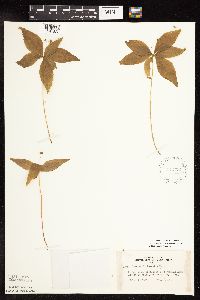 Lysimachia borealis (Rafinesque) U. Manns & Anderberg 442772[1141822]Lakela, Olga 129801951-07-11 United States, Minnesota, Saint Louis, High ledges on Namakan Lake at Kettle Falls.;Voyageurs National Park;070N;18W;, 48.5214443 -92.6653567 |
MIN:Plants | 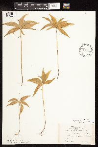 Lysimachia borealis (Rafinesque) U. Manns & Anderberg 443348[1141887]Lakela, Olga 128101951-06-28 United States, Minnesota, Saint Louis, Back of the Moon Lodge, Sandpoint Lake;Voyageurs National Park;;;, 48.39881 -92.478147 |
MIN:Plants | 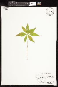 Lysimachia borealis (Rafinesque) U. Manns & Anderberg 443871[1141980]Myhre, K. 48871994-06-06 United States, Minnesota, Itasca, Itasca County...Located 0.7 mile southeast of Minisogama Lake...T 147N R 29W NE1/4 of SW1/4 of Sec 35;Chippewa National Forest / Leech Lake Indian Reservation;147N;29W;35, 47.5078416 -94.3179391 |
MIN:Plants | 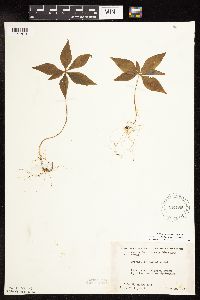 Lysimachia borealis (Rafinesque) U. Manns & Anderberg 444985[1141813]Moore, John; et al. 175321945-06-29 United States, Minnesota, Isanti, 4 1/2 mi N of Cambridge;;;;, 45.64861 -93.22792 |
MIN:Plants | 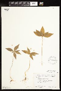 Lysimachia borealis (Rafinesque) U. Manns & Anderberg 445103[1141801]Moore, John; et al. 186091946-06-13 United States, Minnesota, Lake of the Woods, At Rocky Point, Lake of the Woods.;;163N;34W;, 48.9305062 -95.0257583 |
MIN:Plants | 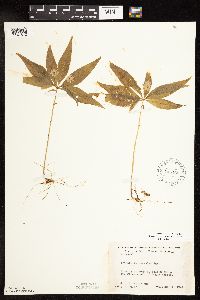 Lysimachia borealis (Rafinesque) U. Manns & Anderberg 445166[1141812]Moore, John; et al. 194871947-06-11 United States, Minnesota, Itasca, 12 1/2 mi S of Grand Rapids;;;;, 47.056221 -93.530214 |
MIN:Plants | 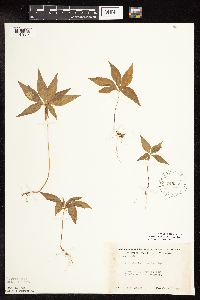 Lysimachia borealis (Rafinesque) U. Manns & Anderberg 448865[1141927]Moore, John 170291945-06-06 United States, Minnesota, Todd, 1/2 mi E of Staples;;;;, 46.355518 -94.781752 |
MIN:Plants | 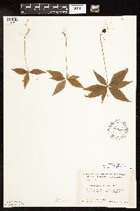 Lysimachia borealis (Rafinesque) U. Manns & Anderberg 449282[1141811]Moore, John; et al. 167501944-08-02 United States, Minnesota, Itasca, Itasca County...8 mi N of Grand Rapids;;;;, 47.408783 -93.527634 |
MIN:Plants |  Lysimachia borealis (Rafinesque) U. Manns & Anderberg 457040[1141979]Smith, Welby 146941988-08-04 United States, Minnesota, Mille Lacs, Mille lacs [sic] Co.; about 11 miles north of Milaca...SW1/4 SE1/4 sec.26, T 40N R 27W;;040N;27W;26, 45.925 -93.6680556 |
MIN:Plants |  Lysimachia borealis (Rafinesque) U. Manns & Anderberg 458679[1141867]Puchalski, L. 3251993-07-29 United States, Minnesota, Polk, Polk County...Hagen WPA. App. 2/3 mi. north of SE corner of site; T 148 R 39W SE1/4 of NE1/4 of Sec 34;Hagen Wildlife Management Area;148N;39W;34, 47.5935023 -95.6070396 |
MIN:Plants |  Lysimachia borealis (Rafinesque) U. Manns & Anderberg 460893[1141866]Sather, Nancy s.n.1995-08-08 United States, Minnesota, Mahnomen, Mahnomen County...east of Tamarack Lake; County Biological Survey Site 111. T145 R39 SENW of Sec 23;White Earth Indian Reservation;145N;39W;23, 47.3609206 -95.5838241 |
MIN:Plants |  Lysimachia borealis (Rafinesque) U. Manns & Anderberg 462664[1141896]Lakela, Olga 143741952-06-22 United States, Minnesota, Saint Louis, Namakan Narrows, International boundry;Voyageurs National Park;069N;17W;27, 48.4334352 -92.4992692 |
MIN:Plants | 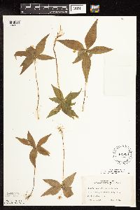 Lysimachia borealis (Rafinesque) U. Manns & Anderberg 462958[1141895]Lakela, Olga 140771952-05-31 United States, Minnesota, Saint Louis, Floodwood Lake, #73 St. Louis Co.;;054N;21W;18, 47.1597528 -93.0549387 |
MIN:Plants | 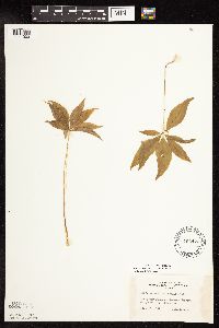 Lysimachia borealis (Rafinesque) U. Manns & Anderberg 463473[1141903]Lakela, Olga 141571952-06-17 United States, Minnesota, Saint Louis, At Namakan Narrow, St. Louis Co.;Voyageurs National Park;069N;17W;27, 48.4334352 -92.4992692 |
MIN:Plants | 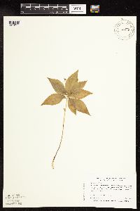 Lysimachia borealis (Rafinesque) U. Manns & Anderberg 475615[1141790]Myhre, K. 1681991-07-02 United States, Minnesota, Aitkin, Wealthwood State Forest. Aitkin County...2.5 miles north of Mille Lacs Lake on township road 51, east side of the road. Private land; T 45N R 26W SW1/4 of NE1/4 of Sec 8. 045N 24W 8, 46.398935 -93.4000214 |
MIN:Plants | 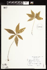 Lysimachia borealis (Rafinesque) U. Manns & Anderberg 475710[1141789]DeMink, L. 0051999-07-21 United States, Minnesota, Clearwater, Itasca State Park. Clearwater Co, Itasca State Park, Beaver Lake area. T143N, R36W, SW 1/4 of NW 1/4 of S17; SW corner of Beaver Lake, 100 ft. from Wilderness Drive.. 143N 36W 17, 47.2025359 -95.2655969 |
MIN:Plants | 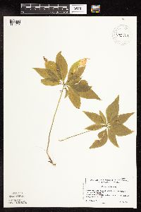 Lysimachia borealis (Rafinesque) U. Manns & Anderberg 475740[1141795]Locke, M. 31999-07-29 United States, Minnesota, Clearwater, Clearwater Co, Itasca State Park, west side of Bud [sic] Lake, T143N R36W sec 36;Itasca State Park;143N;36W;36, 47.1598529 -95.1798808 |
MIN:Plants |  Lysimachia borealis (Rafinesque) U. Manns & Anderberg 481180[1141935]Lakela, Olga 160311953-06-08 United States, Minnesota, Saint Louis, Treasure Island in Vermilion Lake;Superior National Forest;;;, 47.883729 -92.425514 |
MIN:Plants | 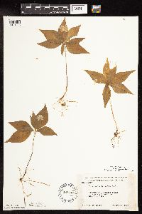 Lysimachia borealis (Rafinesque) U. Manns & Anderberg 488648[1141926]Moore, John 200371949-06-01 United States, Minnesota, Otter Tail, Big Pine Lake;;;;, 46.609302 -95.4955 |
MIN:Plants | 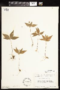 Lysimachia borealis (Rafinesque) U. Manns & Anderberg 507450[1141810]Moore, John; et al. 209781951-06-07 United States, Minnesota, Itasca, Itasca County...Back of lake shore of Coon Lake, Scenic State Park.;Scenic State Park;;;, 47.716639 -93.563657 |
MIN:Plants | 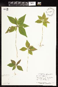 Lysimachia borealis (Rafinesque) U. Manns & Anderberg 508345[1141833]Smith, Welby 129391987-06-11 United States, Minnesota, Fillmore, Fillmore County...about 2 1/2 mi SW of Peterson, in the Root River Valley...SE1/4 SW1/4 sec.35, T104N R9W;Dorer Memorial Hardwood State Forest;104N;09W;35, 43.7675472 -91.8800272 |
MIN:Plants | 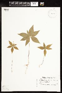 Lysimachia borealis (Rafinesque) U. Manns & Anderberg 514723[1141791]Smith, Welby 193331991-07-09 United States, Minnesota, Koochiching, Pine Island State Forest. Koochiching County...along Hickes Ridge Road, about 5 miles SW of Big Falls...T154N R26W NW1/4 of SW1/4 of Sec 24. 154N 26W 24, 48.1402778 -93.9269444 |
MIN:Plants | 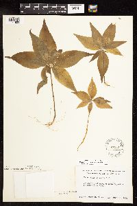 Lysimachia borealis (Rafinesque) U. Manns & Anderberg 524459[1141823]Benner, J. s.n.1938-06-19 United States, Minnesota, Cook, just back of Lake Superior on Temperance River. Cook Co.;North Shore / Temperance River State Park;059N;04W;, 47.5993592 -90.8441887 |
MIN:Plants | 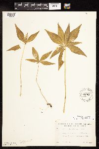 Lysimachia borealis (Rafinesque) U. Manns & Anderberg 525594[1141820]Lakela, Olga 186191955-05-28 United States, Minnesota, Saint Louis, Floodwood River terrace, Hwy 73, N of Meadowlands jcn.;;;;, 47.123137 -92.996995 |
MIN:Plants | 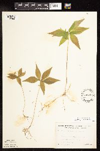 Lysimachia borealis (Rafinesque) U. Manns & Anderberg 525737[1141893]Lakela, Olga 186891955-06-04 United States, Minnesota, Saint Louis, Lake Kabetogama Road near jnc with hwy #53;Kabetogama State Forest;;;, 48.408617 -93.049089 |
MIN:Plants | 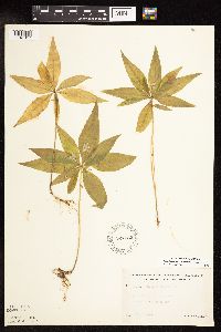 Lysimachia borealis (Rafinesque) U. Manns & Anderberg 527032[1141917]Lakela, Olga 177451954-06-15 United States, Minnesota, Saint Louis, Shorewoods of Pelican Lake, W of Orr;Kabetogama State Forest;;;, 48.05139 -92.871484 |
MIN:Plants | 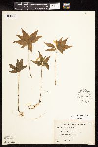 Lysimachia borealis (Rafinesque) U. Manns & Anderberg 527248[1141898]Lakela, Olga 173341954-06-07 United States, Minnesota, Saint Louis, Lake Vermilion above Vermilion River dam;Superior National Forest;;;, 48.01003 -92.456679 |
MIN:Plants | 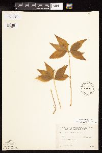 Lysimachia borealis (Rafinesque) U. Manns & Anderberg 527267[1141907]Lakela, Olga 179481954-07-24 United States, Minnesota, Saint Louis, St. Louis County ... Gun Lake, Superior National Forest, north of Ely;Superior National Forest;065N;12W;14, 48.1147682 -91.8320176 |
MIN:Plants | 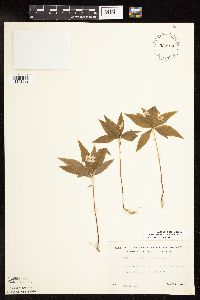 Lysimachia borealis (Rafinesque) U. Manns & Anderberg 532904[1141902]Lakela, Olga 198451956-06-16 United States, Minnesota, Saint Louis, on the point facing the narrows of Seven Beaver Lake, S side;;;;, 47.492374 -91.812716 |
MIN:Plants | 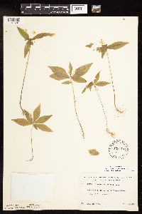 Lysimachia borealis (Rafinesque) U. Manns & Anderberg 533178[1141936]Lakela, Olga 197741956-06-12 United States, Minnesota, Saint Louis, N of Sturgeon Lake, hwy 5 Morcom T.;;;;, 47.733622 -93.01837 |
MIN:Plants | 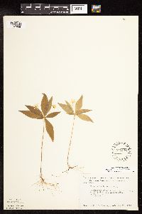 Lysimachia borealis (Rafinesque) U. Manns & Anderberg 542446[1141956]Lawrence, B.; et al. 216321952-05-25 United States, Minnesota, Anoka, Cedar Creek National History Area. Anoka County...In Cedar Creek Bog Lake Swamp, NW1/4 Sec. 27, Athens Twp, '40 A' In Cedar Creek Bog Lake Swamp, NW1/4 Sec. 27, Athens Twp, '40 A'. 034N 23W 27, 45.4067795 -93.1937266 |
MIN:Plants | 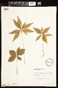 Lysimachia borealis (Rafinesque) U. Manns & Anderberg 552527[1141799]Partch, M. s.n.1958-08-10 United States, Minnesota, Mahnomen, Mahnomen Co. Oakland Twp, Balsam Beach Woods;White Earth Indian Reservation / White Earth State Forest;143N;40W;, 47.1936905 -95.741927 |
MIN:Plants | 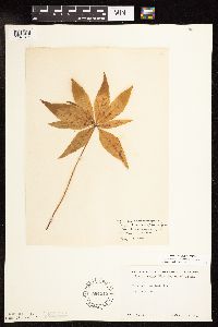 Lysimachia borealis (Rafinesque) U. Manns & Anderberg 564515[1141814]Rhone, R. s.n.1940-08-23 United States, Minnesota, Crow Wing, East Twin Lake, Crow Wing Co.;;;;, 46.560512 -94.130337 |
MIN:Plants | 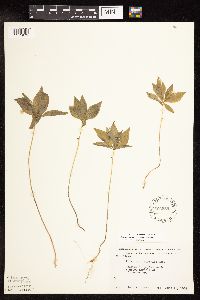 Lysimachia borealis (Rafinesque) U. Manns & Anderberg 566585[1141975]Moore, John 238731958-06-12 United States, Minnesota, Kittson, 8 mi NE of Lancaster;;;;, 48.94011 -96.679788 |
MIN:Plants | Lysimachia borealis (Rafinesque) U. Manns & Anderberg 568899[]Moore, John 253601961-06-02 United States, Minnesota, Anoka, Anoka County...W side of Fish Lake;Cedar Creek National History Area;034N;23W;26, 45.4069008 -93.1731469 |
MIN:Plants | 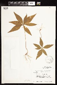 Lysimachia borealis (Rafinesque) U. Manns & Anderberg 572574[1141816]Moore, John 257051961-08-07 United States, Minnesota, Anoka, Anoka County...NE of the Cornea Cabin, Cedar Creek Natural History Area.;Cedar Creek National History Area;034N;23W;, 45.4280632 -93.2039968 |
MIN:Plants | 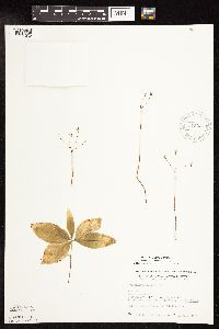 Lysimachia borealis (Rafinesque) U. Manns & Anderberg 575037[1141962]Wertman, Freida 1191960-07-18 United States, Minnesota, Anoka, Cedar Creek Natural History Area, Cedar Lake Bog, Section 27w, Athens Twp, Coordinates, Map Area surveyed 1960 879-2205;Cedar Creek National History Area;034N;23W;27, 45.4067795 -93.1937266 |
MIN:Plants | 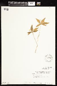 Lysimachia borealis (Rafinesque) U. Manns & Anderberg 583372[1141808]Kellner, H. 1611956-06-19 United States, Minnesota, Lake, Lake County...Beside L. Superior, Encampment Forest.;North Shore;053N;10W;11, 47.0934095 -91.5741945 |
MIN:Plants | 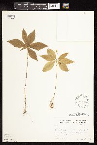 Lysimachia borealis (Rafinesque) U. Manns & Anderberg 586374[1141958]Bowers, T. 441962-06-29 United States, Minnesota, Clearwater, LaSalle Trail, Larch swamp, 1/4 mi from Itasca Park Drive;Itasca State Park;143N;36W;, 47.19557 -95.2332161 |
MIN:Plants | 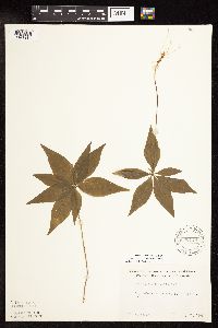 Lysimachia borealis (Rafinesque) U. Manns & Anderberg 590118[1141914]Meierotto, R. s.n.1962-07-26 United States, Minnesota, Becker, Becker Co. Sec. 5 T142N R36W;Itasca State Park;142N;36W;05, 47.1449325 -95.2653681 |
MIN:Plants | 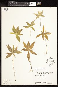 Lysimachia borealis (Rafinesque) U. Manns & Anderberg 592358[1141915]Westkaemper, Remberta s.n.1962-05-00 United States, Minnesota, Stearns, Stearns Co. St. Joseph;;124N;29W;10, 45.5661717 -94.3116988 |
MIN:Plants | 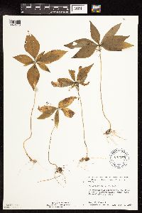 Lysimachia borealis (Rafinesque) U. Manns & Anderberg 603647[1141963]Moore, John; et al. 272191967-08-03 United States, Minnesota, Isanti, West shore of Beckman Lake.;Cedar Creek Ecosystem Preserve;034N;23W;22, 45.4212985 -93.1939292 |
MIN:Plants | 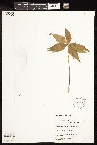 Lysimachia borealis (Rafinesque) U. Manns & Anderberg 606993[1141946]Davidson, Donald s.n.1966-07-20 United States, Minnesota, Saint Louis, Minnesota Point;Minnesota Point;049N;13W;18, 46.758681 -92.077494 |
MIN:Plants | 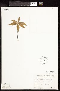 Lysimachia borealis (Rafinesque) U. Manns & Anderberg 607022[1141948]Davidson, Donald s.n.1967-06-24 United States, Minnesota, Saint Louis, Minnesota Point, Duluth;Minnesota Point;049N;13W;18, 46.7587 -92.077311 |
MIN:Plants | 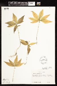 Lysimachia borealis (Rafinesque) U. Manns & Anderberg 607344[1141913]Grafstrom, M. 181968-06-11 United States, Minnesota, Pine, Pine Co. T10N R18W NW1/4 Sec. 12;Saint Croix State Park;040N;18W;12, 45.9723843 -92.545919 |
MIN:Plants | 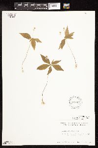 Lysimachia borealis (Rafinesque) U. Manns & Anderberg 611493[1141883]Lammers, Roberta s.n.1967-06-21 United States, Minnesota, Isanti, Near Beckman Lake, Cedar Creek Natural History Area;Cedar Creek National History Area;034N;23W;22, 45.4212985 -93.1939292 |
MIN:Plants | 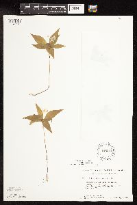 Lysimachia borealis (Rafinesque) U. Manns & Anderberg 616541[1141912]Moore, John; et al. 891969-06-03 United States, Minnesota, Crow Wing, Crow Wing Natural Area, Crow Wing County...E of Chandler Lake, SW1/4 Sec. 22 Garrison Twp.;Crow Wing Natural Area;044N;28W;22, 46.2789902 -93.8633363 |
MIN:Plants | 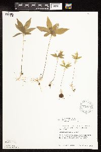 Lysimachia borealis (Rafinesque) U. Manns & Anderberg 623133[1141916]Moore, John 273821971-06-04 United States, Minnesota, Isanti, Along the W shore of Beckman Lake, Athens Twp, Cedar Creek Natural History Area;Cedar Creek National History Area;034N;23W;22, 45.4212985 -93.1939292 |
MIN:Plants | 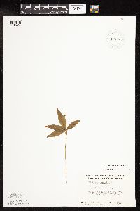 Lysimachia borealis (Rafinesque) U. Manns & Anderberg 663693[1141920]Noble, Mark; et al. 640B1975-07-05 United States, Minnesota, Saint Louis, St. Louis Co. ... on Moose Loop, 28 mi NW of Ely, for Superior Nat. For.;Superior National Forest;065N;14W;, 48.1068827 -92.1263804 |
MIN:Plants | 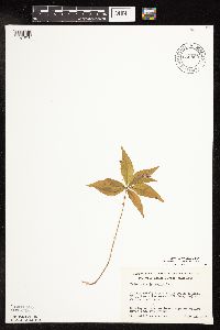 Lysimachia borealis (Rafinesque) U. Manns & Anderberg 669860[1141918]Wheeler, Gerald s.n.1974-06-22 United States, Minnesota, Aitkin, Aitkin County...Ca. 3 mi S of Hill City, 2 mi E of hwy 169 on Willow River Road, NW edge of Willow River Bog;Hill River State Forest;;;, 46.902778 -93.583501 |
MIN:Plants | 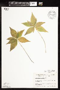 Lysimachia borealis (Rafinesque) U. Manns & Anderberg 669866[1141919]Wheeler, Gerald s.n.1974-06-22 United States, Minnesota, Aitkin, Aitkin County...2 mi S of Aitkin, woods W of hwy 169;;;;, 46.503923 -93.712524 |
MIN:Plants | 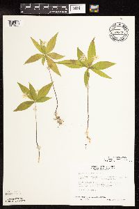 Lysimachia borealis (Rafinesque) U. Manns & Anderberg 686797[1141905]Wheeler, Gerald; et al. 12231977-05-14 United States, Minnesota, Itasca, Itasca County...Ca. 10 mi NW of Grand Rapids; SE1/4 SE1/4 Sec. 19 T56N R26W;;056N;26W;19, 47.3181714 -93.6919665 |
MIN:Plants | 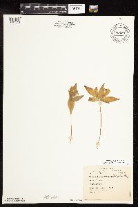 Lysimachia borealis (Rafinesque) U. Manns & Anderberg 689339[1141818]Anonymous s.n.1924-06-04 United States, Minnesota, Hennepin, Purgatory Swamp, near Eden Prairie;;117N;22W;00, 44.9350602 -93.4619061 |
MIN:Plants | 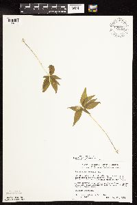 Lysimachia borealis (Rafinesque) U. Manns & Anderberg 698026[1141829]Wheeler, Gerald; et al. 28261978-05-23 United States, Minnesota, Beltrami, Beltrami County...NW1/4 SE1/4 Sec36, T156N, R31W; approximately 9 mi N of the Waskish Airport on Rte 72, a little over 0.25 mi W of the road. Near the trail leading to Ludlow Lake. Ludlow Lookout Tower Area.. 156N 31W 36, 48.2872438 -94.5642346 |
MIN:Plants |  Lysimachia borealis (Rafinesque) U. Manns & Anderberg 698140[1141828]Wheeler, Gerald; et al. 29401978-06-08 United States, Minnesota, Beltrami, Approximately 11 mi N of the Washkish Airport on Rte 72, about 0.1 mi E of the road. Coll Site no. 4.;Red Lake Peatland Scientific Natural Area;156N;30W;19, 48.3160528 -94.5433611 |
MIN:Plants |  Lysimachia borealis (Rafinesque) U. Manns & Anderberg 698940[1141952]Sather, Nancy; et al. 4831977-08-15 United States, Minnesota, Saint Louis, St. Louis Co. Plot G12...SW1/4 SW1/4 Sec. 28 T57N R12W;Superior National Forest;057N;12W;28, 47.3939419 -91.8665493 |
MIN:Plants |  Lysimachia borealis (Rafinesque) U. Manns & Anderberg 698941[1141953]Sather, Nancy; et al. 503 United States, Minnesota, Lake, Plot G27...NW1/4 NW1/4 Sec. 20 T60N R11W. Lake Co.;Superior National Forest;060N;11W;20, 47.6701007 -91.7505071 |
MIN:Plants |  Lysimachia borealis (Rafinesque) U. Manns & Anderberg 698945[1141879]Sather, Nancy; et al. 461976-06-07 United States, Minnesota, Saint Louis, St. Louis Co. Jack Pine Stand...W1/2 Sec. 14 T60N R12W;;060N;12W;14, 47.6802711 -91.8282597 |
MIN:Plants |  Lysimachia borealis (Rafinesque) U. Manns & Anderberg 700471[1141957]Ownbey, Gerald 59211978-06-18 United States, Minnesota, Cass, Cass County...Bowstring Twp, Sucker Bay Rd, 6.1 mi S of its jnc with U.S. rte 2; T144N R29W NW1/4 Sec. 20;Chippewa National Forest / Leech Lake Indian Reservation;144N;29W;20, 47.2741478 -94.3807148 |
MIN:Plants | 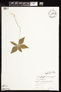 Lysimachia borealis (Rafinesque) U. Manns & Anderberg 701226[1141955]Dorio, J. 1401977-06-07 United States, Minnesota, Benton, Benton Co. Englund Ecotone, ca. 5 mi SE of Rice; T37N R31W Sec. 13;Englund Ecotone, The Nature Conservancy;037N;31W;13, 45.6985631 -94.1434524 |
MIN:Plants | 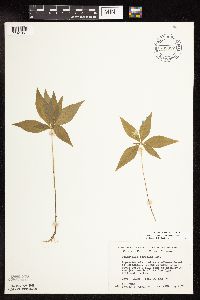 Lysimachia borealis (Rafinesque) U. Manns & Anderberg 708827[1141951]Wheeler, Gerald 38151979-06-13 United States, Minnesota, Carlton, Carlton County...Ca. 6 mi SSE of Wrenshall, woods ca. 1 mi E of hwy 23 and just S of the Soo Line rr tracks; T47N R16W Sec. 22 and 27. 047N 16W , 46.5404252 -92.3534067 |
MIN:Plants | 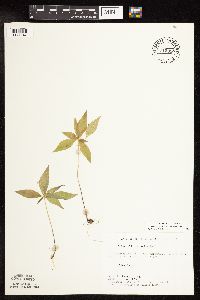 Lysimachia borealis (Rafinesque) U. Manns & Anderberg 715358[1141947]Farrell, P. 331979-06-19 United States, Minnesota, Beltrami, Beltrami County...Lake Bemidji Bog SNA, 1 mi NW of Lake Bemidji; N1/2 of NW1/4 Sec. 24 T147N R33W;Lake Bemidji State Park;147N;33W;24, 47.5332086 -94.810311 |
MIN:Plants | 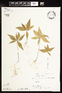 Lysimachia borealis (Rafinesque) U. Manns & Anderberg 715627[1141835]Keller, C. 171979-06-08 United States, Minnesota, Beltrami, Beltrami County ... Pennington Orchid Bog SNA: 1 mile north of Pennington, NW1/4 Sec3, T146N, R30W.;Leech Lake Indian Reservation / Pennington Bog Scientific Natural Area;146N;30W;03, 47.491615 -94.4690408 |
MIN:Plants |  Lysimachia borealis (Rafinesque) U. Manns & Anderberg 717547[1141943]Grimmelbein, G. 381979-06-13 United States, Minnesota, Hubbard, Spearhead Lake Preserve.;Spearhead Lake Preserve (Audubon);145N;34W;00, 47.3680989 -94.9909661 |
MIN:Plants |  Lysimachia borealis (Rafinesque) U. Manns & Anderberg 722470[1141815]Lustig, K. 3041979-05-30 United States, Minnesota, Anoka, Anoka County...Boot Lake SNA: 18 mi SE of Cambridge, Sec. 17, 18, 19, 20, T33N, R22W.;Boot Lake Scientific Natural Area;033N;22W;00, 45.3479647 -93.1130211 |
MIN:Plants |  Lysimachia borealis (Rafinesque) U. Manns & Anderberg 724690[1141880]Smith, Welby 21761980-05-24 United States, Minnesota, Carlton, Carlton County...On the W side of co. hwy 73, about 8 mi S of its jnc with hwy 210 in Cromwell...T47N R20 W NE1/4 NE1/4 Sec. 7. 047N 20W 7, 46.5713229 -92.9182627 |
MIN:Plants |  Lysimachia borealis (Rafinesque) U. Manns & Anderberg 727487[1141882]Smith, Welby 24751980-06-12 United States, Minnesota, Saint Louis, St. Louis County...On the N Side of co. rd 8, ca. 13 mi due E of Floodwood...T51N R18W NW1/4 SW1/4 Sec. 4;;051N;18W;04, 46.9341965 -92.628406 |
MIN:Plants | 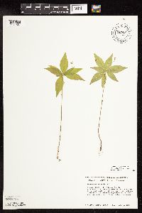 Lysimachia borealis (Rafinesque) U. Manns & Anderberg 727489[1141881]Smith, Welby 22861980-06-01 United States, Minnesota, Wright, Wright County...1/4 mi S of St. hwy 55, and ca. 1.5 mi ESE of the town of Maple Lake; T120N R26W SE1/4 NE1/4 Sec. 8;;120N;26W;08, 45.2167078 -93.9810292 |
MIN:Plants | 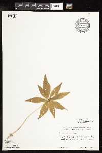 Lysimachia borealis (Rafinesque) U. Manns & Anderberg 728837[1141876]Peterson, Jon s.n.1980-07-13 United States, Minnesota, Houston, Houston Co. 2 mi W of Hokah; T103N R5W Sec. 1 NE1/4 NW1/4;Dorer Memorial Hardwood State Forest;103N;05W;01, 43.7534236 -91.3827081 |
MIN:Plants | 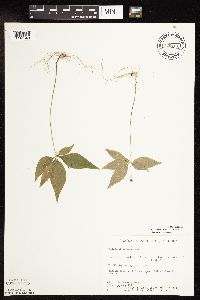 Lysimachia borealis (Rafinesque) U. Manns & Anderberg 729101[1141840]Converse, C. 841980-06-02 United States, Minnesota, Chisago, Chisago County...Goose Creek Natural Area, 5 mi SE of Rush City; SE1/4 SW1/4 Sec. 6 T36N R20W;Wild River State Park;036N;20W;06, 45.6366816 -92.8932544 |
MIN:Plants | 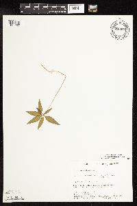 Lysimachia borealis (Rafinesque) U. Manns & Anderberg 729373[1141877]Severson, M. 101980-05-13 United States, Minnesota, Pine, Pine County...St. Croix Natural Area, 21 mi E of Hinckley; NW1/4 Sec. 33 T41N R17W;Saint Croix State Park;041N;17W;33, 45.9905189 -92.4984007 |
MIN:Plants | 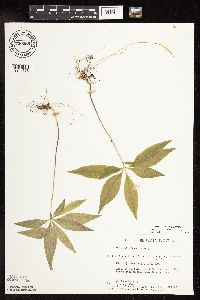 Lysimachia borealis (Rafinesque) U. Manns & Anderberg 730068[1141878]Converse, C. 2451980-06-10 United States, Minnesota, Pine, Pine County...Kettle River Natural Area, 5.5 mi E of Hinckley...NE1/4 SW1/4 Sec. 15 T41N R20W;Kettle River Scientific Natural Area / Sandstone National Wildlife Refuge;041N;20W;15, 46.0330046 -92.8566204 |
MIN:Plants | 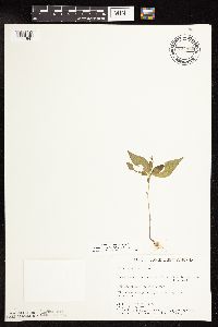 Lysimachia borealis (Rafinesque) U. Manns & Anderberg 734460[1141841]Severson, M. 1591980-05-21 United States, Minnesota, Becker, Becker County...Green Water Lake Natural Area, 5 mi W of Ponsford; SW1/4 SE1/4 Sec. 33 T141N R38W;Greenwater Lake Scientific Natural Area / White Earth Indian Reservation;141N;38W;33, 46.9838935 -95.4976994 |
MIN:Plants | 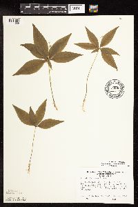 Lysimachia borealis (Rafinesque) U. Manns & Anderberg 743963[1141939]Ownbey, Gerald 68051982-06-19 United States, Minnesota, Aitkin, Aitkin County...Along Co. Rte. 18, 3.5 mi E of its jnc with U.S. rte 65 (1.9 mi E of the Snake River) S side T43N R23W Sec. 14 NE1/4. 043N 23W 14, 46.209463 -93.209968 |
MIN:Plants | 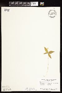 Lysimachia borealis (Rafinesque) U. Manns & Anderberg 744936[1141856]Smith, Welby 41111981-06-06 United States, Minnesota, Wright, Wright County...At the NE end of a small unnamed lake in Hanover...NW1/4 SE1/4 Sec. 35 T120N R24W;;120N;24W;35, 45.1533533 -93.6683201 |
MIN:Plants | 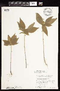 Lysimachia borealis (Rafinesque) U. Manns & Anderberg 748215[1141844]Wheeler, Gerald 55021981-05-30 United States, Minnesota, Pine, Pine County...Sandstone...adjacent to the Kettle River (W bank of river and S of rte 123); T42N R20W Sec. 15;;042N;20W;15, 46.1215688 -92.8557928 |
MIN:Plants | 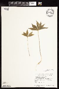 Lysimachia borealis (Rafinesque) U. Manns & Anderberg 749169[1141843]Wheeler, Gerald 54871981-05-18 United States, Minnesota, Stearns, Stearns County...Approx. 1.5 mi W of Rockville on unmarked co. rd, swamp adjacent to the Sauk River; T123N R29W Sec. 8;;123N;29W;08, 45.4793911 -94.3534195 |
MIN:Plants | 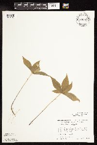 Lysimachia borealis (Rafinesque) U. Manns & Anderberg 749237[1141842]Wheeler, Gerald 55251981-05-30 United States, Minnesota, Pine, Pine County...Sandstone... slope adjacent to the Kettle River (W bank of river and N or rte 123); T42N R20W Sec. 10;Banning State Park;042N;20W;10, 46.1360865 -92.855561 |
MIN:Plants | 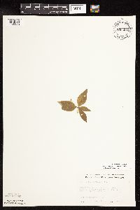 Lysimachia borealis (Rafinesque) U. Manns & Anderberg 750500[1141852]Almendinger, J. 40031981-10-09 United States, Minnesota, Crow Wing, Crow Wing Co. ...Forest 1/4 mi W of co. rd 3; SW of NW of Sec. 31 T136N R27W;;136N;27W;31, 46.5516259 -94.1306065 |
MIN:Plants |  Lysimachia borealis (Rafinesque) U. Manns & Anderberg 753146[1141851]Boe, J. 19031983-06-07 United States, Minnesota, Kittson, Kittson County...Norway Dunes; NW1/4 SE1/4 Sec. 10 T160N R46W;Norway Dunes, The Nature Conservancy;160N;46W;10, 48.6957357 -96.5727704 |
MIN:Plants |  Lysimachia borealis (Rafinesque) U. Manns & Anderberg 758731[1141850]Smith, Welby 63031982-06-13 United States, Minnesota, Wright, Wright County...On the S side of Lake Caroline, ca. 2 mi NNE of South Haven...NE1/4 SW1/4 Sec. 3 T121N R28W;;121N;28W;03, 45.3146868 -94.1923991 |
MIN:Plants |  Lysimachia borealis (Rafinesque) U. Manns & Anderberg 759428[1141849]Smith, Welby 64931982-06-26 United States, Minnesota, Wright, Wright County...Lake Marie State Park, about 1.5 mi E of Silver Creek...SW1/4 SW1/4 Sec. 3 T121N R26W;Lake Maria State Park;121N;26W;03, 45.3184023 -93.9423574 |
MIN:Plants |  Lysimachia borealis (Rafinesque) U. Manns & Anderberg 762783[1141875]Hart, H. s.n.1922-05-26 United States, Minnesota, Hennepin, Purgatory Swamp;;117N;22W;00, 44.9350602 -93.4619061 |
MIN:Plants |  Lysimachia borealis (Rafinesque) U. Manns & Anderberg 763572[1141871]Lugger, O. s.n.1891-06-24 United States, Minnesota, Saint Louis, Lake Vermillion;Superior National Forest;;;, 47.914775 -92.459208 |
MIN:Plants | 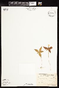 Lysimachia borealis (Rafinesque) U. Manns & Anderberg 764657[1141874]Ballard, A. s.n.1892-07-00 United States, Minnesota, Goodhue, Zumbrota, Goodhue [Co.];;110N;15W;31, 44.2894248 -92.6611953 |
MIN:Plants | 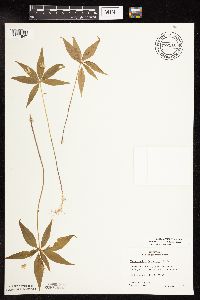 Lysimachia borealis (Rafinesque) U. Manns & Anderberg 772512[1141847]Boe, J. 1121979-06-12 United States, Minnesota, Lake of the Woods, Brown's Lake State Waterfowl Refuge. SW1/4 of section;Beltrami Island State Forest;159N;35W;01, 48.619742 -95.0939896 |
MIN:Plants | 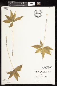 Lysimachia borealis (Rafinesque) U. Manns & Anderberg 772630[1141848]Boe, J. 2021979-06-16 United States, Minnesota, Roseau, Roseau County...Pine plantation near Carp Trail; Sec. 24 R35W T161N;;161N;35W;24, 48.7491929 -95.1012578 |
MIN:Plants | 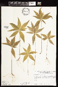 Lysimachia borealis (Rafinesque) U. Manns & Anderberg 774275[1141870]Monson, Paul 53181983-06-14 United States, Minnesota, Saint Louis, Kabetogama Narrows Ranger Station, point adjacent to gas depot; T69N R20W SW1/4 NW1/4 Sec. 25;Voyageurs National Park;069N;20W;25, 48.43325 -92.8423223 |
MIN:Plants | 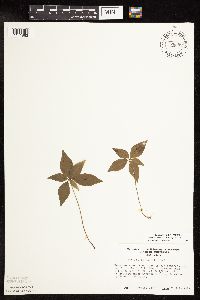 Lysimachia borealis (Rafinesque) U. Manns & Anderberg 776309[1141863]Morley, T. 16441985-07-21 United States, Minnesota, Rice, Rice County...Ca. 1/2 mi S of E side of Shields Lake; T110N R22W SE1/4 SW1/4 Sec. 2;;110N;22W;02, 44.3629405 -93.4330621 |
MIN:Plants | 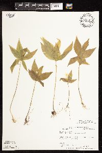 Lysimachia borealis (Rafinesque) U. Manns & Anderberg 777529[1141864]Coffin, Barbara; et al. 83-1061983-06-11 United States, Minnesota, Carlton, Carlton County...Hemlock Ravine SNA; T48N R16W N1/2 NW1/4 SE1/4 Sec. 3;Hemlock Ravine Scientific Natural Area;048N;16W;03, 46.6705626 -92.353928 |
MIN:Plants | 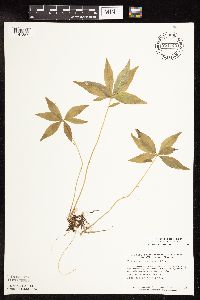 Lysimachia borealis (Rafinesque) U. Manns & Anderberg 781744[1141857]Smith, Welby 89891984-06-11 United States, Minnesota, Morrison, Morrison County...Pellager Peatland, about 4 mi SW of Pellager [sic]...W1/4 NW1/4 Sec. 36 T133N R31W;;133N;31W;36, 46.2896628 -94.5274558 |
MIN:Plants |  Lysimachia borealis (Rafinesque) U. Manns & Anderberg 781764[1141826]Smith, Welby 90311984-06-12 United States, Minnesota, Koochiching, Koochiching County...Forest Grove Peatland, about 9 mi N of Northome...SW1/4 NW1/4 Sec. 3 T152N R29W;Lost River Peatland Scientific Natural Area;152N;29W;03, 48.01314 -94.34368 |
MIN:Plants | 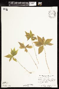 Lysimachia borealis (Rafinesque) U. Manns & Anderberg 781790[1141855]Smith, Welby 91081984-06-13 United States, Minnesota, Roseau, Roseau County...Pinecreek Peatland, about 12 mi NW of Roseau...NE1/4 SW1/4 Sec. 25 T164N R41W;Pine Creek Peatland Scientific Natural Area;164N;41W;25, 48.9963626 -95.8881673 |
MIN:Plants |  Lysimachia borealis (Rafinesque) U. Manns & Anderberg 781848[1141854]Smith, Welby 92381984-06-15 United States, Minnesota, Koochiching, Koochiching County...Nett Lake Peatland, about 1 mi south of Nett Lake...SE1/4 NE1/4 Sec. 33 T65N R22W;Nett Lake Indian Reservation / Nett Lake Peatland Scientific Natural Area;065N;22W;33, 48.0750848 -93.1723009 |
MIN:Plants |  Lysimachia borealis (Rafinesque) U. Manns & Anderberg 794052[1141794]Wheeler, Gerald 62301982-08-10 United States, Minnesota, Mahnomen, White Earth Indian Reservation. Mahnomen County...Approx. 2.3 mi N of the jnc of rt 4 and an unmarked co. rd (runs just W of Lambert Lake), swamp (W of road); T146W R39W Sec. 34. 146N 39W 34, 47.4182411 -95.6039181 |
MIN:Plants |  Lysimachia borealis (Rafinesque) U. Manns & Anderberg 795667[1141938]Wheeler, Gerald 65001982-08-12 United States, Minnesota, Marshall, Thief Lake Wildlife Management Area. Marshall County...Thief Lake Wildlife Management Area 3.6 mi N of the jnc of rte 6 and rte 89 (on E side of rte 89) T158N R39W Sec. 30. 158N 39W 30, 48.4746584 -95.7206248 |
MIN:Plants |  Lysimachia borealis (Rafinesque) U. Manns & Anderberg 797549[1141937]Cholewa, A.; et al. 15231988-08-06 United States, Minnesota, Aitkin, Aitkin Co. Jnc. Long Lake Rd and hwy 5, SE corner of jnc, hill adj to bog; T48N R25W Sec. 14 SW1/4 of NW1/4;;048N;25W;14, 46.6452239 -93.4744583 |
MIN:Plants |  Lysimachia borealis (Rafinesque) U. Manns & Anderberg 804474[1141865]Smith, Welby 114491986-05-16 United States, Minnesota, Sherburne, Sherburne National Wildlife Refuge. Sherburne County...Sherburne National Wildlife Refuge, about 4 mi NNW of Orrock, along the Blue Hill Trail. SW1/4 NW1/4 Sec. 28 T35N R27W. 035N 27W 28, 45.4972222 -93.7180556 |
MIN:Plants |  Lysimachia borealis (Rafinesque) U. Manns & Anderberg 815924[1141862]Wheeler, Gerald 103951988-05-23 United States, Minnesota, Norman, Norman County...Ca. 8 mi ENE of Twin Valley, 0.5 mi N of Faith on rte 40; S1/2 NE1/4 Sec. 14 T144N R43W (Fossum Twp.);;144N;43W;14, 47.2893138 -96.0988905 |
MIN:Plants |  Lysimachia borealis (Rafinesque) U. Manns & Anderberg 817625[1141793]Engels, A. s.n.1991-05-22 United States, Minnesota, Aitkin, Aitkin Co. T49N, R25W, Sec. 33, Ca. 2 1/2 mi. SW of Palisade, along the Mississippi River.;;049N;25W;33, 46.3411666 -93.5043355 |
Google Map
Google Maps is a web mapping service provided by Google that features a map that users can pan (by dragging the mouse) and zoom (by using the mouse wheel). Collection points are displayed as colored markers that when clicked on, displays the full information for that collection. When multiple species are queried (separated by semi-colons), different colored markers denote each individual species.