University of Minnesota
http://www.umn.edu/
612-625-5000
http://www.umn.edu/
612-625-5000
Minnesota Biodiversity Atlas
Bell Museum
Dataset: MIN-Plants
Taxa: Myrsinaceae
Search Criteria: excluding cultivated/captive occurrences
Bell Museum plants | |
 MIN:Plants | 170326[1188636]Steele, E. S. United States, District of Columbia, Detailed locality information protected. This is typically done to protect rare or threatened species localities. |
MIN:Plants | 503723[1188637]Russell, N. H. United States, New York, Albany, Detailed locality information protected. This is typically done to protect rare or threatened species localities. |
MIN:Plants | 581315[1188638]Charette, L. A. United States, Vermont, Chittenden, Detailed locality information protected. This is typically done to protect rare or threatened species localities. |
MIN:Plants | 502531[1188639]Rugel, F. United States, Detailed locality information protected. This is typically done to protect rare or threatened species localities. |
MIN:Plants | 170308[1188640]Cole, E. J. United States, Michigan, Kent, Detailed locality information protected. This is typically done to protect rare or threatened species localities. |
MIN:Plants | 170320[1188641]Wilkinson, E. United States, Ohio, Richland, Detailed locality information protected. This is typically done to protect rare or threatened species localities. |
MIN:Plants | 292606[1188642]Norton, J. B. United States, South Carolina, Darlington, Detailed locality information protected. This is typically done to protect rare or threatened species localities. |
MIN:Plants | 170309[1188643]Herron, C. L. United States, Michigan, Van Buren, Detailed locality information protected. This is typically done to protect rare or threatened species localities. |
MIN:Plants | 170328[1188644]Watson, J. R. United States, Ohio, Cuyahoga, Detailed locality information protected. This is typically done to protect rare or threatened species localities. |
MIN:Plants | 404277[1188645]Sargent, F. H. United States, Virginia, Fairfax, Detailed locality information protected. This is typically done to protect rare or threatened species localities. |
MIN:Plants | 961097[1334241]Timothy J. S. Whitfeld United States, Rhode Island, Providence, Detailed locality information protected. This is typically done to protect rare or threatened species localities. |
MIN:Plants | 0963213[1348084] United States, Maine, Detailed locality information protected. This is typically done to protect rare or threatened species localities. |
MIN:Plants | 0963214[1348085] United States, Indiana, Detailed locality information protected. This is typically done to protect rare or threatened species localities. |
MIN:Plants | 0963215[1348086] United States, Massachusetts, Detailed locality information protected. This is typically done to protect rare or threatened species localities. |
MIN:Plants |  Lysimachia borealis (Rafinesque) U. Manns & Anderberg 427045[1141983]Lee, Michael; et al. MDL36262004-06-15 United States, Minnesota, Becker, Sucker Creek County Park. Becker County...Sucker Creek Park on the southeast side of Big Detroit Lake, three miles southeast of the city of Detroit Lakes...along Sucker Creek...T138N R41W NW1/4 of NE1/4 Sec. 13. 138N 41W 13, 46.7673875 -95.8060823 |
MIN:Plants |  Lysimachia borealis (Rafinesque) U. Manns & Anderberg 421759[1188891]Ahlgren, Clifford 8921950-08-10 Canada, Ontario, Rainy River, 1/8 mile west of Doe Lake, Quetico Park;;;;, 48.709031 -91.149182 |
MIN:Plants |  Lysimachia borealis (Rafinesque) U. Manns & Anderberg 606953[1188890]Davidson, Donald s.n.1966-07-28 United States, Wisconsin, Douglas, Wisconsin Point, Superior;;;;, 46.69972 -92.00139 |
MIN:Plants |  Lysimachia borealis (Rafinesque) U. Manns & Anderberg 355126[1188895]Manning, Sara s.n.1884-06-05 United States, Wisconsin, Pierce, Maiden Rock |
MIN:Plants |  Lysimachia borealis (Rafinesque) U. Manns & Anderberg 472919[1141900]Lee, Michael MDL16641997-05-30 United States, Minnesota, Stearns, Stearns County...At the north end of Sylvia Lake 5-3/4 miles north of Melrose...T127N R33W SE1/4 of NW1/4 of NE1/4 Sec. 2 [Sylvia Lake would be T126 not 127]. 126N 33W 2, 45.7524771 -94.7984668 |
MIN:Plants |  Lysimachia borealis (Rafinesque) U. Manns & Anderberg 453910[1141834]Smith, Welby 156381989-07-11 United States, Minnesota, Kanabec, Kanabek County ... Northeast side of Highway 65, about 7.5 miles south of Mora ... NE1/4 SE1/4 section 30, T38N R23W;;038N;23W;30, 45.7519444 -93.2508333 |
MIN:Plants |  Lysimachia borealis (Rafinesque) U. Manns & Anderberg 353902[1188894]Lakela, Olga 25381938-07-03 United States, Wisconsin, Douglas, Superior |
MIN:Plants |  Lysimachia borealis (Rafinesque) U. Manns & Anderberg 472933[1141942]Lee, Michael MDL17691997-06-25 United States, Minnesota, Stearns, Stearns County...2-1/2 miles westsouthwest of St. Stephen...T126N R29W SW1/4 of SW1/4 Sec. 27;;126N;29W;27, 45.695687 -94.3156372 |
MIN:Plants |  Lysimachia borealis (Rafinesque) U. Manns & Anderberg 575748[1188886]Garton, C. 92251961-08-04 Canada, Ontario, Rainy River, Lake of the Woods Provincial Park, McCrosson Twp. |
MIN:Plants |  Lysimachia borealis (Rafinesque) U. Manns & Anderberg 604833[1188885]Dahl, A. s.n.1943-08-01 United States, New Hampshire, Carroll, Chocorua |
MIN:Plants |  Lysimachia borealis (Rafinesque) U. Manns & Anderberg 170963[1141922]Rosendahl, C. 24711910-05-30 United States, Minnesota, Hennepin, Fort Snelling Reservation [old regional park spanning junction of Minnesota and Mississippi rivers] ... Deephaven Swamp;;028N;23W;00, 44.9051624 -93.1664625 |
MIN:Plants |  Lysimachia borealis (Rafinesque) U. Manns & Anderberg 170964[1141846]Bergman, H. 30311914-08-11 United States, Minnesota, Hubbard, Benedict, Minn.;Paul Bunyan State Forest;143N;32W;35, 47.1572871 -94.6956984 |
MIN:Plants |  Lysimachia borealis (Rafinesque) U. Manns & Anderberg 170965[1141817]Bergman, H. 31281914-08-28 United States, Minnesota, Hubbard, Benedict, Quadrat 24A.;;143N;32W;35, 47.1572871 -94.6956984 |
MIN:Plants |  Lysimachia borealis (Rafinesque) U. Manns & Anderberg 170966[1141965]Aiton, G. s.n.1890-06-00 United States, Minnesota, Hennepin, Lake Harriet;;029N;24W;, 44.9919261 -93.2881533 |
MIN:Plants |  Lysimachia borealis (Rafinesque) U. Manns & Anderberg 170967[1141830]Sandberg, John 8341891-08-15 United States, Minnesota, Aitkin, [no further data];;;;, 46.605349 -93.409393 |
MIN:Plants |  Lysimachia borealis (Rafinesque) U. Manns & Anderberg 170968[1141984]Ballard, A. AB21892-07-00 United States, Minnesota, Goodhue, Zumbrota;;110N;15W;31, 44.2894248 -92.6611953 |
MIN:Plants |  Lysimachia borealis (Rafinesque) U. Manns & Anderberg 170969[1141949]Aiton, G. 61-51893-06-00 United States, Minnesota, Hennepin, [no further data];;;;, 45 -93.47 |
MIN:Plants | 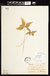 Lysimachia borealis (Rafinesque) U. Manns & Anderberg 170970[1141832]Sheldon, Edmund S21611892-06-00 United States, Minnesota, Aitkin, Nichols;;044N;27W;04, 46.32387 -93.75721 |
MIN:Plants | 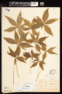 Lysimachia borealis (Rafinesque) U. Manns & Anderberg 170971[1141923]Roberts, J. s.n.1878-06-00 United States, Minnesota, Saint Louis, Duluth;;;;, 46.78333 -92.10639 |
MIN:Plants | 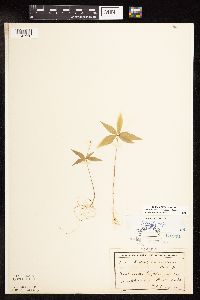 Lysimachia borealis (Rafinesque) U. Manns & Anderberg 170972[1141910]Lyon, H. 5191900-05-22 United States, Minnesota, Wright, Annandale, Wright Co.;;;;, 45.261111 -94.124167 |
MIN:Plants | 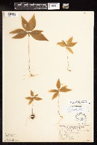 Lysimachia borealis (Rafinesque) U. Manns & Anderberg 170973[1141930]Sandberg, John s.n.1894-06-00 United States, Minnesota, Hennepin, Vicinity of Minneapolis;;029N;24W;25, 44.979965 -93.263836 |
MIN:Plants |  Lysimachia borealis (Rafinesque) U. Manns & Anderberg 170974[1141884]Sheldon, Edmund s.n.1895-05-00 United States, Minnesota, Ramsey, MacCubbin's [McCarrons?] Lake, Ramsey Co.;;029N;23W;, 44.9920769 -93.1663869 |
MIN:Plants |  Lysimachia borealis (Rafinesque) U. Manns & Anderberg 170975[1141945]Ballard, C. B12221893-06-00 United States, Minnesota, Cass, Gull Lake, Cass Co.;;;;, 46.431544 -94.33977 |
MIN:Plants |  Lysimachia borealis (Rafinesque) U. Manns & Anderberg 170976[1141973]Tilden, Josephine s.n.1893-06-00 United States, Minnesota, Cass, Gull Lake;;;;, 46.431425 -94.339083 |
MIN:Plants |  Lysimachia borealis (Rafinesque) U. Manns & Anderberg 170977[1141969]Anderson, A. An3861893-06-00 United States, Minnesota, Cass, Gull Lake;;;;, 46.431425 -94.339083 |
MIN:Plants |  Lysimachia borealis (Rafinesque) U. Manns & Anderberg 170978[1141929]Sheldon, Edmund s.n.1891-05-00 United States, Minnesota, Hennepin, Minneapolis;;029N;24W;25, 44.96996 -93.23702 |
MIN:Plants |  Lysimachia borealis (Rafinesque) U. Manns & Anderberg 170979[1141909]Sandberg, John s.n.1890-06-00 United States, Minnesota, Hennepin, [no further data];;;;, 45 -93.47 |
MIN:Plants |  Lysimachia borealis (Rafinesque) U. Manns & Anderberg 170980[1141964]Sheldon, Edmund S23171892-06-00 United States, Minnesota, Mille Lacs Lake;;;;, 46.242562 -93.646251 |
MIN:Plants |  Lysimachia borealis (Rafinesque) U. Manns & Anderberg 170981[1141873]Burglehaus, F. s.n.1892-06-00 United States, Minnesota, Hennepin, near Minneapolis;;029N;24W;, 44.9919261 -93.2881533 |
MIN:Plants |  Lysimachia borealis (Rafinesque) U. Manns & Anderberg 170982[1141959]Ballard, A. s.n.1892-07-00 United States, Minnesota, Goodhue, Zumbrota;;110N;15W;31, 44.2894248 -92.6611953 |
MIN:Plants |  Lysimachia borealis (Rafinesque) U. Manns & Anderberg 170983[1141985]Sandberg, John s.n.1886-06-00 United States, Minnesota, Chisago, [no further data];;;;, 45.506109 -92.911575 |
MIN:Plants |  Lysimachia borealis (Rafinesque) U. Manns & Anderberg 170984[1141921]Lugger, O. s.n.1891-00-00 United States, Minnesota, Saint Louis, Tower;Superior National Forest;062N;15W;32, 47.8080202 -92.2764478 |
MIN:Plants |  Lysimachia borealis (Rafinesque) U. Manns & Anderberg 170985[1141970]Taylor, B. T12021892-06-00 United States, Minnesota, Chisago, Center City;;034N;20W;34, 45.3897629 -92.8259126 |
MIN:Plants |  Lysimachia borealis (Rafinesque) U. Manns & Anderberg 170986[1141825]Roberts, Thomas s.n.1879-07-30 United States, Minnesota, Cook, Grand Marais;North Shore;061N;01E;21, 47.7525043 -90.4574312 |
MIN:Plants |  Lysimachia borealis (Rafinesque) U. Manns & Anderberg 170987[1141824]Cheney, L. s.n.1891-06-20 United States, Minnesota, Cook, Grand Marais;North Shore;061N;01E;21, 47.7525043 -90.4574312 |
MIN:Plants |  Lysimachia borealis (Rafinesque) U. Manns & Anderberg 170989[1141940]Arthur, J.; et al. B2441886-07-22 United States, Minnesota, Saint Louis, Vermilion Lake;Superior National Forest;;;, 47.891581 -92.366824 |
MIN:Plants |  Lysimachia borealis (Rafinesque) U. Manns & Anderberg 227842[1141885]Holzinger, John s.n.1905-06-00 United States, Minnesota, Winona, [no further data];;;;, 44.0479 -91.6404 |
MIN:Plants |  Lysimachia borealis (Rafinesque) U. Manns & Anderberg 227890[1141950]Rosendahl, C.; et al. 45081924-07-01 United States, Minnesota, Lake, Near Caribou River, North Shore Lake Superior;North Shore / Superior National Forest;;;, 47.518598 -91.051897 |
MIN:Plants |  Lysimachia borealis (Rafinesque) U. Manns & Anderberg 270501[1141961]Vuke, G. s.n.1948-08-00 United States, Minnesota, Clearwater, Itasca State Park, LaSalle Trail;Itasca State Park;;;, 47.197458 -95.201964 |
MIN:Plants |  Lysimachia borealis (Rafinesque) U. Manns & Anderberg 276167[1141982]Grant, Martin 27591929-07-13 United States, Minnesota, Clearwater, Itasca Park...Clearwater Co. Lake Alice Road. SE-SW 1 T.143N R.36W;Itasca State Park;143N;36W;01, 47.2322935 -95.1802373 |
MIN:Plants |  Lysimachia borealis (Rafinesque) U. Manns & Anderberg 276750[1141886]Huff, N. 701914-07-03 United States, Minnesota, Lake, North Kawishiwi River;Superior National Forest;;;, 47.88621 -91.126327 |
MIN:Plants |  Lysimachia borealis (Rafinesque) U. Manns & Anderberg 289413[1141966]Butters, F.; et al. 3481932-07-08 United States, Minnesota, Cook, Susie Island, Lake Superior; T63N R7E;North Shore / Susie Islands, The Nature Conservancy;063N;07E;00, 47.973776 -89.578978 |
MIN:Plants |  Lysimachia borealis (Rafinesque) U. Manns & Anderberg 291827[1141924]Fryklund, P. s.n.1925-06-14 United States, Minnesota, Roseau, [no further data];;;;, 48.773277 -95.783813 |
MIN:Plants |  Lysimachia borealis (Rafinesque) U. Manns & Anderberg 301990[1141908]Himebaugh, W. s.n.1928-05-00 United States, Minnesota, Chisago, Taylors Falls;Saint Croix National Riverway;034N;19W;25, 45.404742 -92.6622287 |
MIN:Plants |  Lysimachia borealis (Rafinesque) U. Manns & Anderberg 333621[1141974]Orr, L. 91929-07-25 United States, Minnesota, Cook, Cook County...SW1/4 Sec. 12 T64N R2W;Superior National Forest;064N;02W;12, 48.0411541 -90.5228538 |
MIN:Plants |  Lysimachia borealis (Rafinesque) U. Manns & Anderberg 337667[1141821]Lakela, Olga 13941936-06-05 United States, Minnesota, Saint Louis, Sec 18, Duluth;;;;, 46.783273 -92.106579 |
MIN:Plants |  Lysimachia borealis (Rafinesque) U. Manns & Anderberg 348410[1141954]Buell, Murray; et al. 6871933-08-02 United States, Minnesota, Anoka, Anoka County...N of Decodon pond;Cedar Creek National History Area;034N;23W;27, 45.4067795 -93.1937266 |
MIN:Plants |  Lysimachia borealis (Rafinesque) U. Manns & Anderberg 351186[1141845]Seashore, Mauritz s.n.1932-05-29 United States, Minnesota, Clearwater, Itasca State Park;Itasca State Park;146N;36W;00, 47.4561952 -95.2402127 |
MIN:Plants |  Lysimachia borealis (Rafinesque) U. Manns & Anderberg 352683[1141904]Benner, F.; et al. 6691929-08-23 United States, Minnesota, Cook, Hat Point about 2 mi east Grand Portage;Grand Portage Indian Reservation / North Shore;063N;06E;, 47.9584678 -89.7035757 |
MIN:Plants |  Lysimachia borealis (Rafinesque) U. Manns & Anderberg 356308[1141827]Stevenson, J. 601922-06-22 United States, Minnesota, Beltrami, Bemidji;;146N;33W;09, 47.47555 -94.87442 |
MIN:Plants |  Lysimachia borealis (Rafinesque) U. Manns & Anderberg 359288[1141819]Alaspa, E.; et al. s.n.1940-06-17 United States, Minnesota, Carlton, U of Minn Foerst Experimant Station 5 mi SW of Cloquet.;;;;, 46.704908 -92.525156 |
MIN:Plants |  Lysimachia borealis (Rafinesque) U. Manns & Anderberg 360201[1141911]Rosendahl, C.; et al. 70151938-09-05 United States, Minnesota, Lake of the Woods, 3 mi S of Rocky Point, Lake of the Woods.;;;;, 48.916855 -95.068008 |
MIN:Plants |  Lysimachia borealis (Rafinesque) U. Manns & Anderberg 360255[1141897]Lakela, Olga 34901940-06-10 United States, Minnesota, Saint Louis, Bank of St. Louis River on hwy 4, ca. 4 mi S of Markham;;;;, 47.225398 -92.2167 |
MIN:Plants |  Lysimachia borealis (Rafinesque) U. Manns & Anderberg 360277[1141894]Lakela, Olga; et al. 35321940-06-12 United States, Minnesota, Carlton, On hwy 23, near Duquette;;;;, 46.369667 -92.553251 |
MIN:Plants |  Lysimachia borealis (Rafinesque) U. Manns & Anderberg 360648[1141972]Lakela, Olga 36121940-07-04 United States, Minnesota, Cook, Windigo Point, Sea Gull Lake. Cook Co.;Boundary Waters Canoe Area Wilderness / Superior National Forest;065N;05W;, 48.149256 -90.887916 |
MIN:Plants |  Lysimachia borealis (Rafinesque) U. Manns & Anderberg 361826[1141872]Lakela, Olga 35441940-06-14 United States, Minnesota, Carlton, St. Louis River, S side;Jay Cooke State Park;048N;16W;, 46.6342494 -92.3645882 |
MIN:Plants |  Lysimachia borealis (Rafinesque) U. Manns & Anderberg 367900[1141899]Dayton, E. s.n.1944-05-30 United States, Minnesota, Anoka, Cedar Creek Bog.;Cedar Creek National History Area;034N;23W;27, 45.4067795 -93.1937266 |
MIN:Plants |  Lysimachia borealis (Rafinesque) U. Manns & Anderberg 370147[1141925]Moore, John; et al. 141101941-05-24 United States, Minnesota, Pine, NW1/4 Sec. 28, Rock Creek Twp. Pine Co.;;038N;20W;28, 45.7517542 -92.8471248 |
MIN:Plants |  Lysimachia borealis (Rafinesque) U. Manns & Anderberg 370526[1141831]Moore, John; et al. 132671940-06-25 United States, Minnesota, Aitkin, 7/10 of a mi S of McGrath. Aitkin Co.;;043N;23W;05, 46.2385775 -93.2723717 |
MIN:Plants |  Lysimachia borealis (Rafinesque) U. Manns & Anderberg 372391[1141892]Lakela, Olga 43891941-06-22 United States, Minnesota, Saint Louis, On Normanna Road ca. 14 mi N of Duluth;;;;, 46.981731 -92.107266 |
MIN:Plants |  Lysimachia borealis (Rafinesque) U. Manns & Anderberg 380181[1141806]Lakela, Olga 54781943-08-28 United States, Minnesota, Lake, Lake County...Top of the Palisade Head, Hwy 61.;North Shore / Palisade Head;056N;07W;22, 47.32413 -91.2136413 |
MIN:Plants |  Lysimachia borealis (Rafinesque) U. Manns & Anderberg 385704[1141807]Lakela, Olga 57721944-08-14 United States, Minnesota, Lake, On Pancake Island in Lake Superior, between East Beaver Bay and the Palisades. Lake Co.;North Shore;055N;07W;00, 47.2788356 -91.2748382 |
MIN:Plants |  Lysimachia borealis (Rafinesque) U. Manns & Anderberg 392936[1141931]Lakela, Olga 68641947-06-21 United States, Minnesota, Saint Louis, Island Lake woods, S shore, 19 mi N of Duluth;;;;, 46.992749 -92.168833 |
MIN:Plants |  Lysimachia borealis (Rafinesque) U. Manns & Anderberg 393428[1141932]Lakela, Olga 68761947-06-28 United States, Minnesota, Saint Louis, On #9 between Duluth and Fish Lake;;;;, 46.865996 -92.19818 |
MIN:Plants |  Lysimachia borealis (Rafinesque) U. Manns & Anderberg 400552[1141977]Loula, E. 161938-07-18 United States, Minnesota, Cook, Forest: Superior, Exact Locality: T61N R2W Sec. 15;North Shore / Superior National Forest;061N;02W;15, 47.7668016 -90.5641944 |
MIN:Plants |  Lysimachia borealis (Rafinesque) U. Manns & Anderberg 400553[1141978]Dahl, A. 741945-06-17 United States, Minnesota, Cook, Cook Co. ...(South Lake Trail near Poplar Lake);Superior National Forest;064N;02W;01, 48.055732 -90.5227793 |
MIN:Plants |  Lysimachia borealis (Rafinesque) U. Manns & Anderberg 400568[1141967]Butters, F.; et al. 6241940-06-29 United States, Minnesota, Cook, Island on W side of South Fowl Lake;Boundary Waters Canoe Area Wilderness / Superior National Forest;064N;03E;, 48.0187918 -90.0555267 |
MIN:Plants |  Lysimachia borealis (Rafinesque) U. Manns & Anderberg 400569[1141968]Butters, F.; et al. s.n.1935-06-29 United States, Minnesota, Cook, Clearwater Lake; T65N R1E;Boundary Waters Canoe Area Wilderness / Superior National Forest;065N;01E;00, 48.0810547 -90.3151891 |
MIN:Plants |  Lysimachia borealis (Rafinesque) U. Manns & Anderberg 400570[1141971]Brown, Spencer 131935-00-00 United States, Minnesota, Cook, Grand Portage; T63N R6E;Grand Portage Indian Reservation / North Shore;063N;06E;04, 47.9694745 -89.6848413 |
MIN:Plants |  Lysimachia borealis (Rafinesque) U. Manns & Anderberg 400571[1141976]Butters, F.; et al. 591936-06-20 United States, Minnesota, Cook, Cliffs on Clearwater Lake; T65N R1E;Boundary Waters Canoe Area Wilderness / Superior National Forest;065N;01E;, 48.0810547 -90.3151891 |
MIN:Plants |  Lysimachia borealis (Rafinesque) U. Manns & Anderberg 405363[1141934]Lakela, Olga 80661949-05-21 United States, Minnesota, Saint Louis, At Prairie Lake, SW St. Louis Co.;;050N;20W;29, 46.7879541 -92.9028984 |
MIN:Plants |  Lysimachia borealis (Rafinesque) U. Manns & Anderberg 407181[1141933]Lakela, Olga 85601949-06-26 United States, Minnesota, Saint Louis, White Iron Lake, E of Ely;Superior National Forest;;;, 47.854667 -91.82744 |
MIN:Plants |  Lysimachia borealis (Rafinesque) U. Manns & Anderberg 407757[1141960]Lakela, Olga 87541969-07-10 United States, Minnesota, Lake, At the Hubachek Estate, Basswood Lake [this was on Back Bay];Boundary Waters Canoe Area Wilderness / Superior National Forest;064N;10W;00, 48.0144057 -91.6101002 |
MIN:Plants |  Lysimachia borealis (Rafinesque) U. Manns & Anderberg 412504[1141809]Moore, John; Moore, Marjorie 118881939-08-18 United States, Minnesota, Koochiching, Koochiching County...Base of a rocky slope East of Tilson Bay, Rainy Lake.;;071N;22W;, 48.6091636 -93.1574133 |
MIN:Plants |  Lysimachia borealis (Rafinesque) U. Manns & Anderberg 412574[1141800]Moore, John; et al. 110401939-07-21 United States, Minnesota, Lake of the Woods, Lake of the Woods County...1 mi up from the mouth of Pine Creek, Angle Inlet, 3/4 of a mi W of the creek.;Northwest Angle;168N;34W;, 49.3446208 -95.0288931 |
MIN:Plants |  Lysimachia borealis (Rafinesque) U. Manns & Anderberg 416806[1141890]Lakela, Olga 83661949-06-20 United States, Minnesota, Saint Louis, Armstrong Lake, NE of Soudan;Superior National Forest;;;, 47.849423 -92.078 |
MIN:Plants |  Lysimachia borealis (Rafinesque) U. Manns & Anderberg 419073[1141804]Ahlgren, Clifford 731949-05-22 United States, Minnesota, Lake, Quetico-Superior Wilderness Research Center...Lake Co, Sec 9, T64N, R10W.;Boundary Waters Canoe Area Wilderness / Superior National Forest;064N;10W;09, 48.0316509 -91.6188616 |
MIN:Plants |  Lysimachia borealis (Rafinesque) U. Manns & Anderberg 419151[1141803]Ahlgren, Clifford 1661949-05-22 United States, Minnesota, Lake, Quetico-Superior Wilderness Research Center...Lake Co, Sec 9, T64N, R10W.;Boundary Waters Canoe Area Wilderness / Superior National Forest;064N;10W;09, 48.0316509 -91.6188616 |
MIN:Plants |  Lysimachia borealis (Rafinesque) U. Manns & Anderberg 419908[1141891]Lakela, Olga 102481950-06-10 United States, Minnesota, Saint Louis, near Gappas Landing, Lake Kabetogama;Voyageurs National Park;;;, 48.437695 -93.027374 |
MIN:Plants |  Lysimachia borealis (Rafinesque) U. Manns & Anderberg 420811[1141889]Lakela, Olga 116171950-08-22 United States, Minnesota, Saint Louis, between Crooked and Iron Lakes, Curtain Falls;Boundary Waters Canoe Area Wilderness / Superior National Forest;066N;12W;06, 48.2307941 -91.9170265 |
MIN:Plants |  Lysimachia borealis (Rafinesque) U. Manns & Anderberg 421655[1141805]Ahlgren, Clifford 10341950-08-22 United States, Minnesota, Saint Louis, Collected along portage trail 1/8 mi W of Curtain Falls, Crooked Lake.;Boundary Waters Canoe Area Wilderness / Superior National Forest;066N;12W;, 48.1867867 -91.8699675 |
MIN:Plants |  Lysimachia borealis (Rafinesque) U. Manns & Anderberg 422479[1141928]Lakela, Olga 74341948-05-31 United States, Minnesota, Saint Louis, On Grand Rapids Road ca. 8 mi NW of Duluth;;;;, 46.865103 -92.226172 |
MIN:Plants |  Lysimachia borealis (Rafinesque) U. Manns & Anderberg 422490[1141802]Lakela, Olga 63661946-06-22 United States, Minnesota, Lake, Beaver Island in Lake Superior, East Beaver Bay. Lake Co.;North Shore;055N;07W;05, 47.2835745 -91.2544516 |
MIN:Plants |  Lysimachia borealis (Rafinesque) U. Manns & Anderberg 429419[1141788]Tjader, Harvey 91999-07-29 United States, Minnesota, Clearwater, Itasca State Park. Clearwater Co, Itasca State Park, Red Pine Trail, about 400 meters west of County Road 122, T143N, R36W Sec. 36 NE1/4 of NE1/4.. 143N 36W 36, 47.1598529 -95.1798808 |
MIN:Plants |  Lysimachia borealis (Rafinesque) U. Manns & Anderberg 440056[1141941]Smith, Welby 129661987-06-16 United States, Minnesota, Washington, Washington County...on the E side of Highway 4, about 1/2 mi NW of Marine on St. Croix...about 150 ft above the floodplain of the St. Croix River; SW1/4 NE1/4 sec.1, T31N R20W. 031N 20W 1, 45.2061111 -92.7797222 |
MIN:Plants | 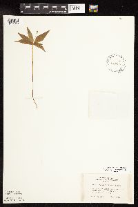 Lysimachia borealis (Rafinesque) U. Manns & Anderberg 442335[1141888]Lakela, Olga 124491951-06-19 United States, Minnesota, Saint Louis, Curtain Falls Resort, Crooked Lake;Boundary Waters Canoe Area Wilderness / Superior National Forest;066N;12W;06, 48.2307941 -91.9170265 |
Google Map
Google Maps is a web mapping service provided by Google that features a map that users can pan (by dragging the mouse) and zoom (by using the mouse wheel). Collection points are displayed as colored markers that when clicked on, displays the full information for that collection. When multiple species are queried (separated by semi-colons), different colored markers denote each individual species.