University of Minnesota
http://www.umn.edu/
612-625-5000
http://www.umn.edu/
612-625-5000
Minnesota Biodiversity Atlas
Bell Museum
Dataset: MIN-Plants
Taxa: Myrsinaceae
Search Criteria: excluding cultivated/captive occurrences
Bell Museum plants | |
 MIN:Plants |  Lysimachia borealis (Rafinesque) U. Manns & Anderberg 817646[1141798]Cholewa, A. 19941991-06-08 United States, Minnesota, Aitkin, Aitkin Co. Solano State Forest, 1.2 mi W of US hwy 65 on West White Pine Road; T45N, R23W, S19.;Solana State Forest;045N;23W;19, 46.3685989 -93.2942467 |
MIN:Plants |  Lysimachia borealis (Rafinesque) U. Manns & Anderberg 825652[1141901]Marion, J. s.n.1982-00-00 United States, Minnesota, Cook, Cook Co, North Shore of Lake Superior, ca. 200 ft. from lakeshore.;North Shore;;;, 47.46396 -91.02551 |
MIN:Plants |  Lysimachia borealis (Rafinesque) U. Manns & Anderberg 825659[1141792]Cholewa, A.; et al. 19641991-06-01 United States, Minnesota, Aitkin, Savanna State Forest. Aitkin Co, Savanna State Forest, end of logging road ca. 3 mi W of co.hwy.10 (Great River Rd.), ca. 8 mi N of co.hwy.18, T51N R24W S16.. 051N 24W 16, 46.9053293 -93.3892226 |
MIN:Plants |  Lysimachia borealis (Rafinesque) U. Manns & Anderberg 829282[1141796]Myhre, K. 21411992-06-08 United States, Minnesota, Cass, Cass County...Located 1.2 mi S of Moose Lake...T136N R31W SE1/4 of SE1/4 of Sec 21;;136N;31W;21, 46.5796122 -94.5934558 |
MIN:Plants | 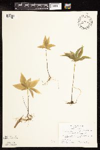 Lysimachia borealis (Rafinesque) U. Manns & Anderberg 832095[1141861]Bagley, S. 71969-06-02 United States, Minnesota, Cook, St. Louis County...Sec.28 R-4W R-66N;Boundary Waters Canoe Area Wilderness / Superior National Forest;066N;04W;28, 48.1711074 -90.8460901, 436m |
MIN:Plants | 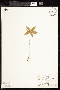 Lysimachia borealis (Rafinesque) U. Manns & Anderberg 832096[1141860]Robertson, Steve s.n.1981-07-11 United States, Minnesota, Saint Louis, County: St. Louis...R-12W T-63N SW 1/4 2;Boundary Waters Canoe Area Wilderness / Superior National Forest;063N;12W;02, 47.9691959 -91.8316476, 427m |
MIN:Plants | 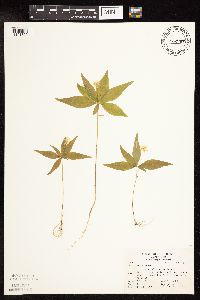 Lysimachia borealis (Rafinesque) U. Manns & Anderberg 832097[1141859]Carter, J.; et al. s.n.1981-06-13 United States, Minnesota, Saint Louis, St. Louis Co.; on N slope of Low Lake, 20 ft. from shore...R-16W T-63N Sec.2;Boundary Waters Canoe Area Wilderness / Superior National Forest;063N;16W;02, 47.9683871 -92.3416398, 415m |
MIN:Plants | 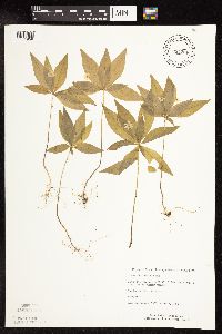 Lysimachia borealis (Rafinesque) U. Manns & Anderberg 834266[1141858]Monson, Paul 59521984-06-06 United States, Minnesota, Cook, Grand Portage National Monument; Cook Co, R-5E, T-64N, S-25, Ca. 4 mi NW of Visitor Center;Grand Portage National Monument / North Shore;064N;05E;25, 47.9981442 -89.7482849 |
MIN:Plants |  Lysimachia borealis (Rafinesque) U. Manns & Anderberg 835668[1141797]Cholewa, A.; et al. 21581995-06-01 United States, Minnesota, Aitkin, Aitkin Co. Savanna Portage State Park, about 17 mi NE of McGregor, SW end of Wolf Lake, T50N R22W S6NE1/4;Savanna Portage State Park;050N;22W;06, 46.845996 -93.1774497 |
MIN:Plants |  Lysimachia borealis (Rafinesque) U. Manns & Anderberg 836042[1141787]Smith, Welby 173161990-07-17 United States, Minnesota, Morrison, Camp Ripley Military Reservation. Camp Ripley Military Reservation. Morrison County...on the S side of Argonne Road, about 0.5 km S of Ferrell Lake; UTM: 390700E 5106500N T130N R30W NE1/4 of NE1/4 of Sec 2. 130N 30W 2, 46.1002284 -94.4216996 |
MIN:Plants |  Lysimachia borealis (Rafinesque) U. Manns & Anderberg 461265[1141981]Gerdes, Lynden; et al. 30551998-05-22 United States, Minnesota, Cook, In vicinity of portage between John Lake and the Royal River. Riparian zone between river and upland. NWNE of sec.;Boundary Waters Canoe Area Wilderness / Superior National Forest;064N;03E;03, 48.0574761 -90.04601 |
MIN:Plants |  Lysimachia borealis (Rafinesque) U. Manns & Anderberg 909928[1141906]Lee, Michael MDL42182006-06-07 United States, Minnesota, Wadena, Wadena County...headwaters of Little Swamp Creek, 5.5 miles northeast of Nimrod...T137N R33W NE1/4 of SE1/4 Sec. 12 UTM: 5172475N 363203E. 137N 33W 12, 46.6950968 -94.7970919 |
MIN:Plants |  Lysimachia borealis (Rafinesque) U. Manns & Anderberg 527302[1188892]Lakela, Olga 177891954-07-04 Canada, Ontario, Rainy River, in view of Rebecca Falls at the end of portage from Iron Lake |
MIN:Plants |  Lysimachia borealis (Rafinesque) U. Manns & Anderberg 170988[1188888]Wheeler, William 8071900-08-00 United States, Michigan, Keweenaw, Tobin's Harbor, Isle Royale;Isle Royale National Park;;;, 48.00056 -88.83333 |
MIN:Plants |  Lysimachia borealis (Rafinesque) U. Manns & Anderberg 170946[1188896]Manning, Sara s.n.1884-06-05 United States, Wisconsin, Pierce, Maiden Rock |
MIN:Plants |  Lysimachia borealis (Rafinesque) U. Manns & Anderberg 528331[1188887]Garton, C. 20151952-08-05 Canada, Ontario, Thunder Bay, North shore of Little Pigeon Bay, Lake Superior, Crooks Township |
MIN:Plants | Lysimachia borealis (Rafinesque) U. Manns & Anderberg 569995[]US Nat. Arboretum staff 1541977-00-00 United States, Minnesota, Crow Wing, Crow Wing Co.;;;;, 46.482372 -94.070879 |
MIN:Plants | 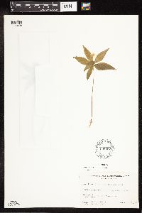 Lysimachia borealis (Rafinesque) U. Manns & Anderberg 606957[1188893]Davidson, Donald s.n.1967-06-22 United States, Wisconsin, Douglas, Wisconsin Point, Superior;;;;, 46.69972 -92.00139 |
MIN:Plants | 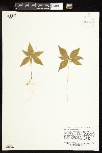 Lysimachia borealis (Rafinesque) U. Manns & Anderberg 909922[1141868]Lee, Michael MDL42712006-06-27 United States, Minnesota, Otter Tail, Otter Tail County...2.5 miles north-northeast of Hillview, 6.5 miles southwest of Menahga...headwaters of Cat Creek ...T137N R36W SE1/4 of NE1/4 of NW1/4 Sec. 4, SE1/4 of NW1/4 Sec. 4...UTM's: 5175755N 328974E; 5175586N 328846E; 5175508N 328727E. 137N 36W 4, 46.7095724 -95.2373956 |
MIN:Plants | 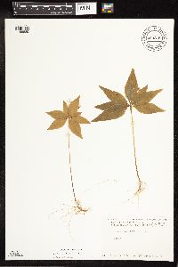 Lysimachia borealis (Rafinesque) U. Manns & Anderberg 680215[1188889]Coffin, Barbara 3801976-07-12 United States, Wisconsin, Bayfield, Presque Isle Point, Stockton Island;Apostle Islands National Lakeshore;;;, 46.920639 -90.548142 |
MIN:Plants | 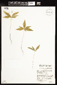 Lysimachia borealis (Rafinesque) U. Manns & Anderberg 924646[1141869]Cholewa, A. 28102011-07-08 United States, Minnesota, Anoka, Island Lake, north of picnic area along trail around north end of lake.;Martin-Island-Linwood Lakes County Park;033N;22W;09, 45.3627837 -93.0915675 |
MIN:Plants | 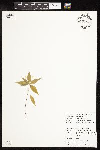 Lysimachia borealis (Rafinesque) U. Manns & Anderberg 924825[1141836]Chayka, K. KC-11072011-06-05 United States, Minnesota, Ramsey, West of the main parking lot at Sucker Lake. NW1/4 of section;Snail Lake Vadnais Lake County Park;030N;22W;19, 45.0758333 -93.1019444 |
MIN:Plants | 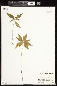 Lysimachia borealis (Rafinesque) U. Manns & Anderberg 931209[1141837]Allen, Kathy; Allen, Adina s.n.2012-06-09 United States, Minnesota, Anoka, Along cedar bog trail north of laboratories.;Cedar Creek National History Area;034N;23W;27, 45.4067795 -93.1937266 |
MIN:Plants | 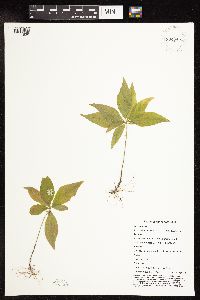 Lysimachia borealis (Rafinesque) U. Manns & Anderberg 934845[1141838]Whitfeld, T. J. S.; et al. 8542012-05-03 United States, Minnesota, Ramsey, [no further data];Battle Creek County Park;;;, 45.03333 -93.08333 |
MIN:Plants | 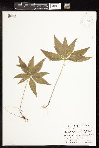 Lysimachia borealis (Rafinesque) U. Manns & Anderberg 936231[1141944]Smith, Welby R; Aaseng, Norm 327632011-06-24 United States, Minnesota, Beltrami, About 16 miles southeast of Fourtown. SE1/4 of SW1/4 of section;Red Lake Indian Reservation;154N;34W;19, 48.1375 -95.0663889 |
MIN:Plants | 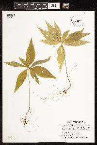 Lysimachia borealis (Rafinesque) U. Manns & Anderberg 939686[1141839]Smith, Welby R. 321792010-08-29 United States, Minnesota, Cook, Near the west side of Caribou Lake, about 4 miles north of Lutsen. NW of SE of section;;060N;03W;02, 47.7067426 -90.6662736 |
MIN:Plants | 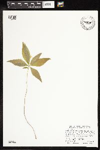 Lysimachia borealis (Rafinesque) U. Manns & Anderberg 941938[1188884]Smith, Welby R. 299702007-05-28 United States, Minnesota, Ramsey, in Shoreview. SE of NE of section;Poplar Lake County Park;030N;23W;01, 45.119131 -93.1105064 |
MIN:Plants | 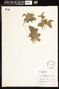 Lysimachia borealis (Rafinesque) U. Manns & Anderberg 546645[1182953]Scoggan, H. J. 6686 Canada, Manitoba |
MIN:Plants | 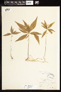 Lysimachia borealis (Rafinesque) U. Manns & Anderberg 170956[1182954]Heller, A. A. s.n. United States, Pennsylvania, Lane |
MIN:Plants | 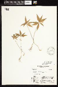 Lysimachia borealis (Rafinesque) U. Manns & Anderberg 581325[1182955]Charette, L. A. 2124 United States, Vermont, Chittenden |
MIN:Plants | 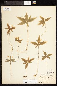 Lysimachia borealis (Rafinesque) U. Manns & Anderberg 257374[1182956]Eames, E. H. s.n. United States, Connecticut, Fairfield |
MIN:Plants | 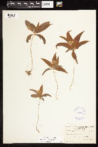 Lysimachia borealis (Rafinesque) U. Manns & Anderberg 351395[1182957]MacElwee, A. 153 United States, New Jersey, Cape May |
MIN:Plants | 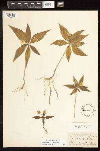 Lysimachia borealis (Rafinesque) U. Manns & Anderberg 487531[1182958]Deane, W. s.n. United States, New Hampshire, Coos |
MIN:Plants | 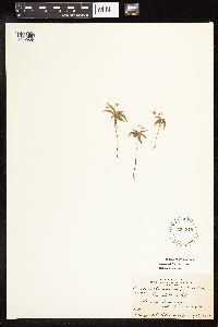 Lysimachia borealis (Rafinesque) U. Manns & Anderberg 533316[1182959]Oldenburg, M. E. 48E Canada, Newfoundland and Labrador |
MIN:Plants | 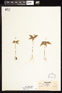 Lysimachia borealis (Rafinesque) U. Manns & Anderberg 170953[1182960]Waghorne, A. C. s.n. Canada, Newfoundland and Labrador |
MIN:Plants | 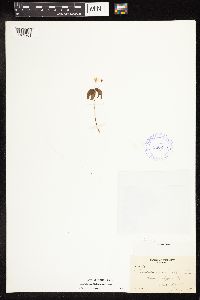 Lysimachia borealis (Rafinesque) U. Manns & Anderberg 380256[1182961]Potter, D. 676 Canada, Quebec |
MIN:Plants | 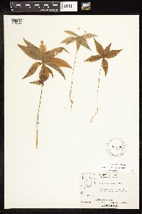 Lysimachia borealis (Rafinesque) U. Manns & Anderberg 555536[1182962]Moir, D. R. 1812 Canada, Ontario, Kenora |
MIN:Plants |  Lysimachia borealis (Rafinesque) U. Manns & Anderberg 170954[1182963]Robinson, B.L. 17 Canada, Newfoundland and Labrador |
MIN:Plants |  Lysimachia borealis (Rafinesque) U. Manns & Anderberg 556245[1182964]Moir, D. R. 100 Canada, Ontario, Kenora |
MIN:Plants |  Lysimachia borealis (Rafinesque) U. Manns & Anderberg 556246[1182965]Moir, D. R. 493 Canada, Ontario, Kenora |
MIN:Plants |  Lysimachia borealis (Rafinesque) U. Manns & Anderberg 555535[1182966]Moir, D. R. 4049 Canada, Ontario, Kenora |
MIN:Plants | 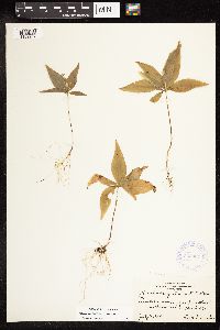 Lysimachia borealis (Rafinesque) U. Manns & Anderberg 363834[1182967]Jacobs, D. L. s86 Canada, Ontario, Thunder Bay |
MIN:Plants | 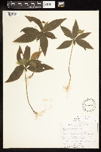 Lysimachia borealis (Rafinesque) U. Manns & Anderberg 536417[1182968]Garton, C. E. 2620 Canada, Ontario, Thunder Bay |
MIN:Plants | 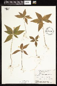 Lysimachia borealis (Rafinesque) U. Manns & Anderberg 449765[1182969]Garton, C. E. 1158 Canada, Ontario, Thunder Bay |
MIN:Plants | 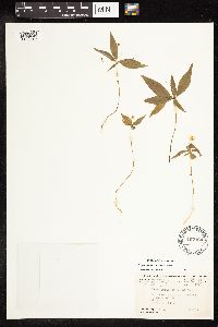 Lysimachia borealis (Rafinesque) U. Manns & Anderberg 497164[1182970]Harper, F. 3530 Canada, Newfoundland and Labrador |
MIN:Plants |  Lysimachia borealis (Rafinesque) U. Manns & Anderberg 523291[1182971]Cooper, W. S. s.n. United States, Michigan, Oakland |
MIN:Plants |  Lysimachia borealis (Rafinesque) U. Manns & Anderberg 556247[1182972]Moir, D. R. 4583 Canada, Ontario, Kenora |
MIN:Plants |  Lysimachia borealis (Rafinesque) U. Manns & Anderberg 556248[1182973]Moir, D. R. 4356 Canada, Ontario, Kenora |
MIN:Plants |  Lysimachia borealis (Rafinesque) U. Manns & Anderberg 618846[1182974]Monserud, W. 606 United States, Wisconsin, Washburn |
MIN:Plants | 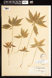 Lysimachia borealis (Rafinesque) U. Manns & Anderberg 170958[1182975]Lucy, T. F. 6790 United States, New York, Chemung |
MIN:Plants | 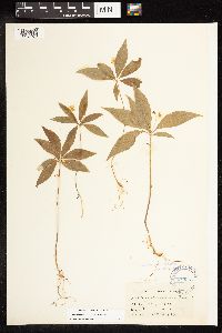 Lysimachia borealis (Rafinesque) U. Manns & Anderberg 170957[1182976]Camp, S. H. s.n. United States, Michigan, Jackson |
MIN:Plants | 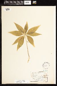 Lysimachia borealis (Rafinesque) U. Manns & Anderberg 170952[1182977]Morris, E. L. s.n. United States, Massachusetts |
MIN:Plants | 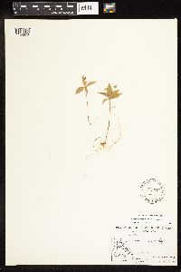 Lysimachia borealis (Rafinesque) U. Manns & Anderberg 533317[1182978]Abbe, E. C. 4234 Canada, Quebec |
MIN:Plants | 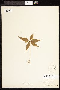 Lysimachia borealis (Rafinesque) U. Manns & Anderberg 525265[1182979]anonymous s.n. United States, Massachusetts, Hampden |
MIN:Plants | 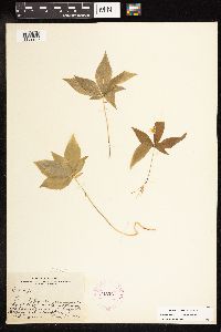 Lysimachia borealis (Rafinesque) U. Manns & Anderberg 245267[1182980]Harris, J. A. C14276 United States, New York, Suffolk |
MIN:Plants | 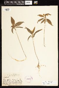 Lysimachia borealis (Rafinesque) U. Manns & Anderberg 245266[1182981]Harris, J. A. C15634 United States, New York, Suffolk |
MIN:Plants | 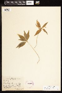 Lysimachia borealis (Rafinesque) U. Manns & Anderberg 245265[1182982]Harris, J. A. C15869 United States, New York, Suffolk |
MIN:Plants |  Lysimachia borealis (Rafinesque) U. Manns & Anderberg 170961[1182983]Thurber, G. s.n. United States, Rhode Island |
MIN:Plants |  Lysimachia borealis (Rafinesque) U. Manns & Anderberg 170949[1182984]Cole, E. J. s.n. United States, Michigan, Kent |
MIN:Plants |  Lysimachia borealis (Rafinesque) U. Manns & Anderberg 170948[1182985]Fernald, M. L. s.n. United States, Maine, Aroostook |
MIN:Plants |  Lysimachia borealis (Rafinesque) U. Manns & Anderberg 282941[1182986]Ricksecker, A. E. 44 United States, Pennsylvania, Warren |
MIN:Plants | 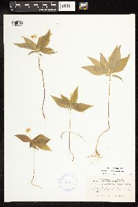 Lysimachia borealis (Rafinesque) U. Manns & Anderberg 387019[1182987]Chrysler, M. A. s.n. United States, New Jersey, Sussex |
MIN:Plants | 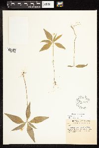 Lysimachia borealis (Rafinesque) U. Manns & Anderberg 598636[1182988]Tryon, R. M. 4569 United States, Indiana, LaPorte |
MIN:Plants | 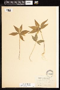 Lysimachia borealis (Rafinesque) U. Manns & Anderberg 170962[1182989]Umbach, L.M. s.n. United States, Indiana, Lake, Miller's |
MIN:Plants | 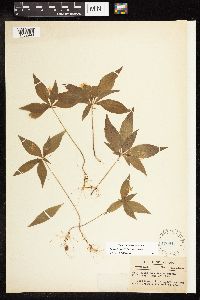 Lysimachia borealis (Rafinesque) U. Manns & Anderberg 170947[1182990]Deam, C. C. 15648 United States, Indiana, LaGrange |
MIN:Plants | 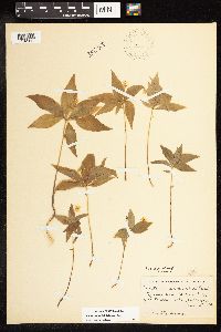 Lysimachia borealis (Rafinesque) U. Manns & Anderberg 270278[1182991]Hermann, F. J. 331 United States, Michigan, Keweenaw |
MIN:Plants | 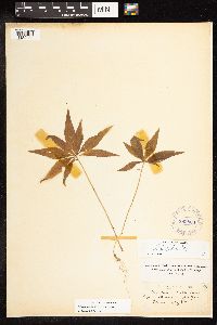 Lysimachia borealis (Rafinesque) U. Manns & Anderberg 383806[1182992]Briggs, J. De Q. s.n. United States, Virginia, Arlington |
MIN:Plants | 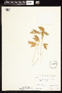 Lysimachia borealis (Rafinesque) U. Manns & Anderberg 548804[1182993]Oldenburg, M. E. 40-101 Canada, Alberta |
MIN:Plants | 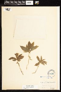 Lysimachia borealis (Rafinesque) U. Manns & Anderberg 170951[1182994]Sornberger, J. D. 71 Canada, Newfoundland and Labrador |
MIN:Plants |  Lysimachia borealis (Rafinesque) U. Manns & Anderberg 822541[1182995]anonymous s.n. Canada, Quebec |
MIN:Plants | 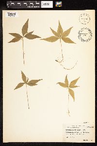 Lysimachia borealis (Rafinesque) U. Manns & Anderberg 448041[1182996]Abbott, R. S. s.n. United States, Connecticut, Litchfield |
MIN:Plants | 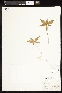 Lysimachia borealis (Rafinesque) U. Manns & Anderberg 170950[1182997]Heller, A. A. 880 United States, Pennsylvania, Lebanon |
MIN:Plants | 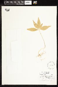 Lysimachia borealis (Rafinesque) U. Manns & Anderberg 170060[1182998]Heller, A. A. s.n. United States, Pennsylvania, Lebanon |
MIN:Plants | 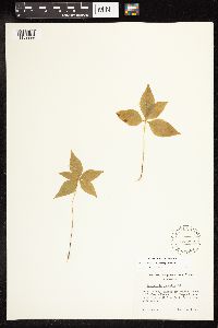 Lysimachia borealis (Rafinesque) U. Manns & Anderberg 563351[1182999]Bennett, H. R. s.n. United States, Wisconsin, Door |
MIN:Plants | 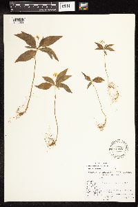 Lysimachia borealis (Rafinesque) U. Manns & Anderberg 543833[1183000]Abbe, E. C. 3169 Canada, Quebec |
MIN:Plants | 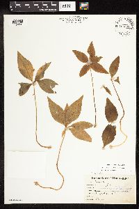 Lysimachia borealis (Rafinesque) U. Manns & Anderberg 765297[1188001]Lugger, O. s.n. United States, New York |
MIN:Plants | 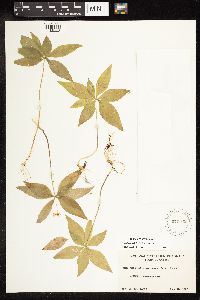 Lysimachia borealis (Rafinesque) U. Manns & Anderberg 570942[1188002]Malte, M. O. 76/23 Canada, Quebec |
MIN:Plants | 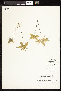 Lysimachia borealis (Rafinesque) U. Manns & Anderberg 594984[1188003]Baldwin, W. K. W. 8651 Canada, Ontario, Kenora |
MIN:Plants | 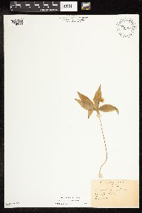 Lysimachia borealis (Rafinesque) U. Manns & Anderberg 766620[1188004]Pettit, R. H. s.n. United States, New York, Tompkins |
MIN:Plants | 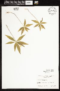 Lysimachia borealis (Rafinesque) U. Manns & Anderberg 643944[1188005]Ahles, H. E. 76391 United States, Massachusetts, Hampshire |
MIN:Plants | 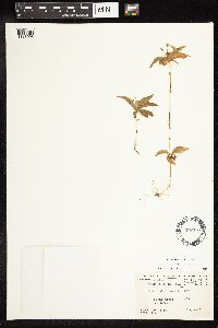 Lysimachia borealis (Rafinesque) U. Manns & Anderberg 497167[1188006]Harper, F. 3730 Canada, Quebec |
MIN:Plants | 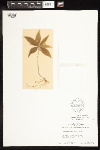 Lysimachia borealis (Rafinesque) U. Manns & Anderberg 607865[1188007]Tuthill, M. s.n. United States, Wisconsin, Monroe |
MIN:Plants |  Lysimachia borealis (Rafinesque) U. Manns & Anderberg 170945[1188008]Rowler, W. W. s.n. United States, New York, Tompkins |
MIN:Plants |  Lysimachia borealis (Rafinesque) U. Manns & Anderberg 170959[1188009]Waghorne, A. C. s.n. Canada, Newfoundland and Labrador |
MIN:Plants |  Lysimachia borealis (Rafinesque) U. Manns & Anderberg 663622[1188010]Jacobson, G. L. 120 Canada, Newfoundland and Labrador |
MIN:Plants |  Lysimachia borealis (Rafinesque) U. Manns & Anderberg 804953[1188011]Garton, C. E. 20718 Canada, Ontario, Thunder Bay |
MIN:Plants |  Lysimachia borealis (Rafinesque) U. Manns & Anderberg 403216[1188012]Wadmond, S. C. [3540] United States, Wisconsin, Walworth |
MIN:Plants |  Lysimachia borealis (Rafinesque) U. Manns & Anderberg 403218[1188013]Wadmond, S. C. 8734 United States, Wisconsin, Kenosha |
MIN:Plants |  Lysimachia borealis (Rafinesque) U. Manns & Anderberg 15054[1188014]Hatch, S. 67 United States, Wisconsin, Rusk |
MIN:Plants |  Lysimachia borealis (Rafinesque) U. Manns & Anderberg 543821[1188015]Abbe, E. C. 3112 Canada, Quebec |
MIN:Plants | 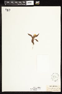 Lysimachia borealis (Rafinesque) U. Manns & Anderberg 170955[1188016]MacFarlane 314-4 Canada, Newfoundland and Labrador |
MIN:Plants | 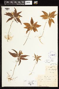 Lysimachia borealis (Rafinesque) U. Manns & Anderberg 403217[1188017]Wadmond, S. C. 7721 United States, Wisconsin, Racine |
MIN:Plants | 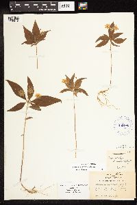 Lysimachia borealis (Rafinesque) U. Manns & Anderberg 403184[1188018]Wadmond, S. C. [3540] United States, Wisconsin, Walworth |
MIN:Plants | 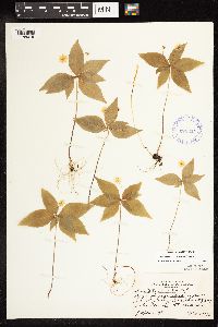 Lysimachia borealis (Rafinesque) U. Manns & Anderberg 373214[1188019]Marr, J. 191 United States, Wisconsin, Vilas |
MIN:Plants | 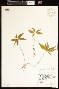 Lysimachia borealis (Rafinesque) U. Manns & Anderberg 947397[1282978]Whitfeld, Timothy J. S. 9162014-05-20 United States, Rhode Island, Washington, Great Swamp Wildlife Management Area, 2.25 miles southwest of West Kingston., 41.45969 -71.59097 |
MIN:Plants | 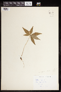 Lysimachia borealis (Rafinesque) U. Manns & Anderberg 960481[1318991]Stork, H.E., Kenk 1948-07-25 United States, Minnesota, Red Lake Reservation, 48.0833 -95.0833 |
MIN:Plants | 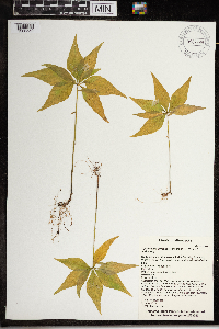 Lysimachia borealis (Rafinesque) U. Manns & Anderberg 967999[1368559]T. J. S. Whitfeld 21582019-06-17 United States, Minnesota, Lake, Boundary Waters Canoe Area Wilderness, northeast part of Alice Lake, 47.947108 -91.208844, 472m |
MIN:Plants | Lysimachia borealis (Rafinesque) U. Manns & Anderberg []Timothy J. S. Whitfeld 32672022-07-01 United States, Minnesota, Washington, Crystal Spring Scientific and Natural Area, 0.4 miles northeast of the intersection of Scandia Trail North and Hwy 95, 45.25709 -92.763989, 264m |
MIN:Plants | Lysimachia borealis (Rafinesque) U. Manns & Anderberg []Timothy J. S. Whitfeld 34232022-07-20 United States, Minnesota, Saint louis, Sax-Zim Bog area, Winterberry Bog, 0.15 miles northwest of intersection of Hwy 52 (Arkola Road) and Hwy 221, 47.169848 -92.539005, 387m |
MIN:Plants |  515711[1144868]Walton, G. 2381992-10-04 United States, Minnesota, Saint Louis, St. Louis Co.; T50N, R14W, Sec.28, north side of 11th ave. West below Skyline Drive, Duluth;;050N;14W;28, 46.7858896 -92.1216363 |
Google Map
Google Maps is a web mapping service provided by Google that features a map that users can pan (by dragging the mouse) and zoom (by using the mouse wheel). Collection points are displayed as colored markers that when clicked on, displays the full information for that collection. When multiple species are queried (separated by semi-colons), different colored markers denote each individual species.