University of Minnesota
http://www.umn.edu/
612-625-5000
http://www.umn.edu/
612-625-5000
Minnesota Biodiversity Atlas
Bell Museum
Dataset: MIN-Plants
Taxa: Urticaceae
Search Criteria: excluding cultivated/captive occurrences
Bell Museum plants | |
 MIN:Plants | Laportea canadensis (L.) Weddell 787647[]Smith, Welby 106141985-07-01 United States, Minnesota, Hennepin, Wolsfeld Woods State Scientific and Natural Area, ca. 2.5 mi W of Plymouth; SW1/4 NE1/4 Sec. 27 T118N R23W;Wolsfeld Woods SNA;118N;23W;27, 45.002224 -93.5733337 |
MIN:Plants | Laportea canadensis (L.) Weddell 788864[]Smith, Welby 103151985-05-30 United States, Minnesota, Le Sueur, LeSueur Co. Richter Woods County Park, about 2 mi W of Montgomery; NW1/4 SE1/4 Sec. 8 T111N R23W;Richter Woods County Park;111N;23W;8, 44.4333344 -93.6138916 |
MIN:Plants | Laportea canadensis (L.) Weddell 800273[]Cholewa, A.; et al. 17451989-07-14 United States, Minnesota, Washington, Carpenter Nature Center. Washington Co, T26N R20W S4...North Ravine, near mouth of ravine;Carpenter Nature Center;026N;20W;04, 44.768259 -92.812758 |
MIN:Plants | Laportea canadensis (L.) Weddell 816040[]Wheeler, Gerald 120061988-09-02 United States, Minnesota, Wilkin, Wilkin Co. Breckenridge (W side), Welles Memorial Park; bordering the Red River; NW1/4 Sec. 9 T132N R47W (Breckenridge T Wilkin Co. Breckenridge (W side), Welles Memorial Park; bordering the Red River; NW1/4 Sec. 9 T132N R47W (Breckenridge Twp.). 132N 47W 9, 46.2567 -96.594353 |
MIN:Plants | Laportea canadensis (L.) Weddell 816276[]Wheeler, Gerald 122721988-09-22 United States, Minnesota, Traverse, Ca. 9 mi NE of Browns Valley, N of rte 27; N1/2 Sec. 29 T126N R48W (Windsor Twp.);;126N;48W;29, 45.695044 -96.72887 |
MIN:Plants | Laportea canadensis (L.) Weddell 816332[]Wheeler, Gerald 114681988-07-27 United States, Minnesota, Lac Qui Parle, Ca. 6 mi NNE of Bellingham, Lac Qui Parle WMA, bordering the Minnesota River; N1/2 Sec. 12 T120N R45W (Agassiz Twp.);;120N;45W;12, 45.217486 -96.237154 |
MIN:Plants | Laportea canadensis (L.) Weddell 833510[]Juhnke, C. 1311991-06-19 United States, Minnesota, Fillmore, Forestville State Park. Fillmore Co. T102N R12W Sec.13 NE SW NE;Forestville State Park;102N;12W;13, 43.637724 -92.219269 |
MIN:Plants | Laportea canadensis (L.) Weddell 834179[]Smith, Welby 198841991-07-31 United States, Minnesota, Todd, Todd CO. About 2 mi S of Grey Eagle; public access at the NW end of Big Birch Lake T127N R32W NE1/4 of SE1/4 of Sec 19 Todd CO. About 2 mi S of Grey Eagle; public access at the NW end of Big Birch Lake. T127N R32W NE1/4 of SE1/4 of Sec 19. 127N 32W 19, 45.7952766 -94.7508316 |
MIN:Plants | Laportea canadensis (L.) Weddell 836307[]Cholewa, A. 24031995-08-10 United States, Minnesota, Aitkin, Savanna Portage State Park. Aitkin Co. Savanna Portage State Park, about 17 mi NE of McGregor, downslope from snowmobile trail along ridge N of Sava Aitkin Co. Savanna Portage State Park, about 17 mi NE of McGregor, downslope from snowmobile trail along ridge N of Savanna Lake, T51N R22W S31 SW1/4 of SW1/4.. 051N 22W 31, 46.850494 -93.192696 |
MIN:Plants | Laportea canadensis (L.) Weddell 837394[]Smith, Welby 183801990-09-13 United States, Minnesota, Morrison, Camp Ripley Military Reservation. Camp Ripley Military Reservation. Morrison Co. About 2 km NW of Crow Wing Lake; floodplain of the Mississippi River; UTM: 394500E 5122500N T132 R29 SW1/4 of NW1/4 of Sec 17. T132N R29W S17, 46.250437 -94.367676 |
MIN:Plants | Laportea canadensis (L.) Weddell 838483[]Smith, Welby 178221990-08-08 United States, Minnesota, Red Lake, Red Lake County ... At 'Old Crossing Treaty State Wayside Park'. On the N bank of the Red Lake River, about 6 miles W of the town of Red Lake Falls ... T151N R45W SE1/4 of SW1/4 of Sec. 27. 151N 45W 27, 47.8666649 -96.4113922 |
MIN:Plants | Laportea canadensis (L.) Weddell 841633[]Smith, Welby 133691987-07-07 United States, Minnesota, Washington, Washington Co. Island in the St. Croix River, about 2 mi NE of Scandia; SE1/4 SE1/4 sec.7, T32N R19W;;032N;19W;7, 45.2675018 -92.7555542 |
MIN:Plants | Laportea canadensis (L.) Weddell 99740[]Campbell, Jennie C1681896-07-00 United States, Minnesota, Stearns, Grand Lake, Stearns Co.;;123N;29W;, 45.436726 -94.337004 |
MIN:Plants | Laportea canadensis (L.) Weddell 99750[]Burglehaus, F. s.n.1892-08-00 United States, Minnesota, Hennepin, Loc. near Minneapolis;;N;;, 44.979965 -93.263836 |
MIN:Plants | Laportea canadensis (L.) Weddell 99751[]Anderson, A. An7811893-08-00 United States, Minnesota, Goodhue, Featherstone;;N;;, 44.501255 -92.611443 |
MIN:Plants | Laportea canadensis (L.) Weddell 99752[]Sheldon, Edmund S401891-06-00 United States, Minnesota, Le Sueur, Elysian;;109N;24W;, 44.198577 -93.673838 |
MIN:Plants | Laportea canadensis (L.) Weddell 99753[]Gilbert, H. 2371923-07-19 United States, Minnesota, Saint Louis, Duluth;;N;;, 46.7833 -92.1 |
MIN:Plants | Laportea canadensis (L.) Weddell 99754[]Anderson, A. An7301893-08-00 United States, Minnesota, Goodhue, Featherstone;;N;;, 44.501255 -92.611443 |
MIN:Plants | Laportea canadensis (L.) Weddell 99755[]Sheldon, Edmund S4601891-06-00 United States, Minnesota, Blue Earth, Madison Lake;;N;;, 44.190628 -93.807612 |
MIN:Plants | Laportea canadensis (L.) Weddell 99756[]Sheldon, Edmund S8541891-07-00 United States, Minnesota, Brown, Sleepy Eye;;N;;, 44.297183 -94.72415 |
MIN:Plants | Laportea canadensis (L.) Weddell 99757[]Ballard, C. B7081891-06-00 United States, Minnesota, Carver, Waconia;;116N;25W;, 44.850796 -93.786909 |
MIN:Plants | Laportea canadensis (L.) Weddell 99758[]Taylor, B. 593a1891-06-00 United States, Minnesota, Faribault, Minnesota Lake;;N;;, 43.837621 -93.860827 |
MIN:Plants | Laportea canadensis (L.) Weddell 99759[]Lyon, H. 1171899-06-17 United States, Minnesota, Houston, Winnebago Valley;Dorer Memorial Hardwood State Forest;N;;, 43.537379 -91.40119 |
MIN:Plants | Laportea canadensis (L.) Weddell 99760[]Sandberg, John s.n.1889-08-00 United States, Minnesota, Hennepin, [no further data];;;;, 45 -93.47 |
MIN:Plants | Laportea canadensis (L.) Weddell 99761[]Holzinger, John s.n.1889-09-21 United States, Minnesota, Winona, Winona;;N;;, 44.0333 -91.6333 |
MIN:Plants | Laportea canadensis (L.) Weddell 99762[]Sandberg, John s.n.1882-07-00 United States, Minnesota, Goodhue, Vasa;;N;;, 44.5033 -92.72242 |
MIN:Plants | Laportea canadensis (L.) Weddell 99763[]Taylor, B. T3051891-06-00 United States, Minnesota, Waseca, Janesville;;N;;, 44.116078 -93.708004 |
MIN:Plants | Laportea canadensis (L.) Weddell 99764[]Aiton, G. s.n.1889-09-00 United States, Minnesota, Hennepin, [no further data];;;;, 45 -93.47 |
MIN:Plants | Laportea canadensis (L.) Weddell 99765[]Sheldon, Edmund S30311892-07-00 United States, Minnesota, Mille Lacs, Milaca;;037N;27W;, 45.755799 -93.654408 |
MIN:Plants | Laportea canadensis (L.) Weddell 99766[]Ballard, C. B2921891-06-00 United States, Minnesota, Scott, Jordan, Scott Co.;;114N;23W;, 44.66532 -93.627759 |
MIN:Plants | Laportea canadensis (L.) Weddell 99767[]Taylor, B. T8111891-07-00 United States, Minnesota, Pope, Glenwood;;N;;, 45.648982 -95.401248 |
MIN:Plants | Laportea canadensis (L.) Weddell 99768[]Herrick, C. s.n.1878-07-00 United States, Minnesota, Hennepin, Minneapolis;;N;;, 44.979965 -93.263836 |
MIN:Plants | Laportea canadensis (L.) Weddell 99769[]Kassube, J. s.n.1877-00-00 United States, Minnesota, Hennepin, Minneapolis;;N;;, 44.979965 -93.263836 |
MIN:Plants | Laportea canadensis (L.) Weddell 99770[]Ballard, C. 32011901-08-17 United States, Minnesota, Clay, Moorhead;;N;;, 46.873852 -96.767581 |
MIN:Plants | Laportea canadensis (L.) Weddell 99771[]Skinner, S. 1521902-06-19 United States, Minnesota, Jackson, Heron Lake Region;;N;;, 43.794959 -95.320276 |
MIN:Plants | Laportea canadensis (L.) Weddell 99772[]Manning, Sara s.n.1888-08-22 United States, Minnesota, Hennepin, Minnehaha;;N;;, 44.915855 -93.208549 |
MIN:Plants | Laportea canadensis (L.) Weddell 99773[]MacMillan, C.; et al. 1931900-08-00 United States, Minnesota, Polk, Crookston;;150N;46W;30, 47.782 -96.60007 |
MIN:Plants | Laportea canadensis (L.) Weddell 99774[]Moyer, Lycurgus s.n.1885-07-00 United States, Minnesota, Chippewa, Chippewa River Bottoms, Chippewa Co.;;N;;, 44.934473 -95.733328 |
MIN:Plants | Laportea canadensis (L.) Weddell 99775[]Anderson, A. A4651893-06-00 United States, Minnesota, Cass, Gull Lake;;N;;, 46.446379 -94.35099 |
MIN:Plants | Laportea canadensis (L.) Weddell 818141[]Engels, A. s.n.1991-08-18 United States, Minnesota, Aitkin, Aitkin Co, T49N R25W S33 nw1/4. Engels Farm, ca. 2-1/2 mi SW. of Palisade ... near Mississippi River;;049N;25W;33, 46.692025 -93.521788 |
MIN:Plants | Laportea canadensis (L.) Weddell 912162[]Smith, Welby 228381993-07-14 United States, Minnesota, Sibley, Vale Wildlife Management Area. Sibley County...Vale State Wildlife Management Area, ca 2.5 miles N-NW of Henderson; in the valley of High Island Creek, ca 2.5 miles SW of its confluence with the Minn R...T 113N R 26W NE1/4 of SW1/4 of Sec 27. 113N 26W 27, 44.5625 -93.9427778 |
MIN:Plants | Laportea canadensis (L.) Weddell 489232[]Juhnke, C. 037 CMJ FRO1998-08-19 United States, Minnesota, Goodhue, Frontenac State Park Goodhue County ... Near trail to Sand Point ... T112N R13W NW SE NW 13;Frontenac State Park;112N;13W;13, 44.50502 -92.31891 |
MIN:Plants | Laportea canadensis (L.) Weddell 913889[]Smith, Welby 225221993-06-18 United States, Minnesota, Douglas, Douglas County... Lake Carlos State Park, about 6 miles north of Alexandria... T129N R37W SE1/4 of SW1/4 of Sec 9;Lake Carlos State Park;129N;37W;09, 45.9958333 -95.3469444 |
MIN:Plants | Laportea canadensis (L.) Weddell 912186[]Smith, Welby 216121992-08-26 United States, Minnesota, Nicollet, Nicollet County...In Seven Mile County Park, about 7 miles north of Mankato...T 109N R 27W NW1/4 of NE1/4 of Sec 11;Seven Mile Creek County Park;109N;27W;11, 44.2680556 -94.0344444 |
MIN:Plants | Laportea canadensis (L.) Weddell 898985[]Smith, Welby 258051995-08-01 United States, Minnesota, Swift, Swift County...Monson Lake State Park...T 121N R 37W NE1/4 of NW1/4 of Sec 1;Monson Lake State Park;121N;37W;01, 45.3236111 -95.2688889 |
MIN:Plants | Laportea canadensis (L.) Weddell 912678[]Lee, Michael MDL44442007-07-11 United States, Minnesota, Wadena, Wadena County...Along the Crow Wing River ~1/2 mile downstream from the mouth of Beaver Creek, 3.5 miles southeast of Nimrod...east side of the river...T136N R33W NW1/4 of SE1/4 Sec. 10...UTM: 5162947N 359785E. 136N 33W 10, 46.610947 -94.830105 |
MIN:Plants | Laportea canadensis (L.) Weddell 912663[]Smith, Welby 244101994-06-17 United States, Minnesota, Anoka, Anoka County...On the west bank of the Rum River, in Rum River Central Regional Park...T32N R24W NW1/4 of SE1/4 of Sec 6;Rum River County Park;032N;24W;06, 45.29 -93.3741667 |
MIN:Plants | Laportea canadensis (L.) Weddell 912838[]Smith, Welby 242051994-05-31 United States, Minnesota, Koochiching, Franz Jevne State Park. Koochiching County...Franz Jevne State Park. In the Rainy River Valley, about 2 miles northeast of Birchdale... T160N R27W SW1/4 of SW1/4 of Sec 26. 160N 27W 26, 48.6427778 -94.0783333 |
MIN:Plants | Laportea canadensis (L.) Weddell 531900[]McGregor, R. 126361956-08-22 United States, Kansas, Douglas, 4 mi. SE Clinton.;;;;, 38.870655 -95.337836 |
MIN:Plants | Laportea canadensis (L.) Weddell 477265[]Smith, Welby 174101990-07-23 United States, Minnesota, Steele, Steele County ... Kaplan Woods City Park, on the south side of Owatonna ... north side of the Straight River ... T 107N R 20W NE1/4 of NW1/4 of sec 21. 107N 20W 21, 44.0644455 -93.2350006 |
MIN:Plants | Laportea canadensis (L.) Weddell 484654[]Lee, Michael; et al. MDL24781998-09-22 United States, Minnesota, Crow Wing, Crow Wing Co.; four miles northeast of Emily; north of Duck Lake; T138N R25W SE1/4 of SE1/4 Sec. 18;;138N;25W;18, 46.762013 -93.885049 |
MIN:Plants | Laportea canadensis (L.) Weddell 911200[]Smith, Welby 219031992-09-03 United States, Minnesota, Watonwan, Watonwan County...About 5 miles east of St. James...South Fork Watonwan River...T 106N R 31W SW1/4 of SE1/4 of Sec 14;;106N;31W;14, 43.9786111 -94.5255556 |
MIN:Plants | Laportea canadensis (L.) Weddell 922486[]Smith, Welby 234581993-08-10 United States, Minnesota, Cottonwood, About 6 miles north-northwest of Storden, along Dutch Charley Creek. SW1/4 of NE1/4 of Sec;;108N;38W;36, 44.1194444 -95.3513889 |
MIN:Plants | Laportea canadensis (L.) Weddell 922672[]Smith, Welby 235311993-08-11 United States, Minnesota, Isanti, about 13 miles southwest of Cambridge. NW1/4 of SW1/4 of Sec;Lyndon Cedarglade County Park;034N;25W;13, 45.4377778 -93.4075 |
MIN:Plants | Laportea canadensis (L.) Weddell 921121[]Smith, Welby 247941994-07-14 United States, Minnesota, Koochiching, Koochiching State Forest. Along the Big Fork River, about 15 mi south of the town of Big Fork [sic; actually Big Falls]... T 63N R 27W NW1/4 of NE1/4 of Sec 14. 063N 27W 14, 47.9538889 -93.755 |
MIN:Plants | Laportea canadensis (L.) Weddell 921068[]Smith, Welby 248291994-07-14 United States, Minnesota, Koochiching, At the Sturgeon River Landing, on the south bank of the Sturgeon river about 4 miles west-northwest of Big Falls. SW1/4 of SW1/4 of section;Pine Island State Forest;155N;25W;29, 48.2116667 -93.8836111 |
MIN:Plants | Laportea canadensis (L.) Weddell 921077[]Smith, Welby 248621994-07-20 United States, Minnesota, Lincoln, Hole-in-the-Mountain County Park. Hole in the Mountain County Park, about one mile west of Lake Benton ...T109N R45W SW1/4 of NE1/4 of Sec 7. 109N 45W 7, 44.262808 -96.31199 |
MIN:Plants | Laportea canadensis (L.) Weddell 922892[]Smith, Welby 237411993-08-27 United States, Minnesota, McLeod, Lake Marion County Park. Lake Marion County Park; on the south side of Lake Marion, about 6 miles south of Hutchinson... T 115N R 30W NE1/4 of NE1/4 of Sec 12. 115N 30W 12, 44.7877778 -94.3811111 |
MIN:Plants | Laportea canadensis (L.) Weddell 922769[]Smith, Welby 237911993-09-01 United States, Minnesota, Mower, Lake Louise State Park. Lake Louise State Park, about 1 mile north-northwest of LeRoy. At the confluence of the Upper Iowa and the Little Iowa Rivers...T 101N R 14W NW1/4 of NE1/4 of Sec 28. 101N 14W 28, 43.5272222 -92.5177778 |
MIN:Plants | Laportea canadensis (L.) Weddell 922612[]Smith, Welby 235001993-08-10 United States, Minnesota, Murray, Lake Shetek State Park, about 3 miles northwest of Currie...T 107N R 40W NW1/4 of NW1/4 of Sec 6;Lake Shetek State Park;107N;40W;06, 44.1061111 -95.7005556 |
MIN:Plants | Laportea canadensis (L.) Weddell 922620[]Smith, Welby 233131993-08-03 United States, Minnesota, Renville, Skalbakken County Park. Skalbakken County Park, in the Minnesota Valley about 4 miles southwest of Sacred Heart. Along the north bank of the Minnesota River...T 115N R 38W SW1/4 of SE1/4 of sec 27. 115N 38W 27, 44.7338889 -95.4097222 |
MIN:Plants | Laportea canadensis (L.) Weddell 922647[]Smith, Welby 234031993-08-04 United States, Minnesota, Wabasha, Carley State Park. Carley State Park, about 3 miles south of Plainview...floodplain of the North Fork Whitewater River...T 108N R 11W NW1/4 of NE1/4 of Sec 32. 108N 11W 32, 44.1194444 -92.175 |
MIN:Plants | Laportea canadensis (L.) Weddell 932704[]Lee, Michael MDL47982008-08-26 United States, Minnesota, Wadena, Along the Redeye River, four miles southeast of Blue Grass, nine miles north-northeast of Verndale. On the west side of the river just downstream from the 211th Avenue bridge. NW1/4 of NW1/4 of SW1/4 of section;;135N;34W;12, 46.5196873 -94.9249592 |
MIN:Plants | Laportea canadensis (L.) Weddell 934910[]Whitfeld, T. J. S.; et al. 7812011-09-06 United States, Minnesota, Chisago, UTM: 15T0519840, 5042913;Wild River State Park;;;, 45.53947 -92.7458761 |
MIN:Plants | Laportea canadensis (L.) Weddell 937029[]Smith, Welby R. 322122010-09-03 United States, Minnesota, Saint Louis, Along the Whiteface River about 6 miles east of Cotton. NE of NE of section;;054N;16W;10, 47.1808761 -92.348627 |
MIN:Plants | Laportea canadensis (L.) Weddell 937635[]Gerdes, Lynden B. 65912012-07-09 United States, Minnesota, Lake, Little Isabella River. Approximately 5.67 miles northwest of Isabella, MN. NW of the foot bridge and river crossing.;Superior National Forest;060N;09W;27, 47.656667 -91.459444 |
MIN:Plants | Laportea canadensis (L.) Weddell 942120[]Smith, Welby R. 319012010-07-27 United States, Minnesota, Dakota, Along the Vermillion River about 7 miles southeast of Hastings. SE of NE of section;;114N;16W;21, 44.6682304 -92.7360854 |
MIN:Plants | Laportea canadensis (L.) Weddell 944062[]Anderson, Chel E. 23512014-08-20 United States, Minnesota, Saint Louis, T67N R17W Section 20 SW 1/4 of the SW 1/4, near confluence with Vermilion River. UTM(NAD83): 532624/5346001, 48.266376 -92.56038626324 |
MIN:Plants |  Laportea canadensis (L.) Weddell 953129[1296415]Lee, Jeffrey G. 1082015-08-11 United States, Minnesota, Saint Louis |
MIN:Plants |  Laportea canadensis (L.) Weddell 953128[1296416]Lee, Jeffrey G. 1072015-06-23 United States, Minnesota, Saint Louis |
MIN:Plants |  Laportea canadensis (L.) Weddell 966157[1356920]T. J. S. Whitfeld 26592020-07-17 United States, Minnesota, Washington, Lost Valley Prairie Scientific and Natural Area, 2 miles east north east of intersection of State Highway 95 and 110th Street, at dead-end of Nyberg Avenue South., 44.799668 -92.819919, 266m |
MIN:Plants |  Laportea canadensis (L.) Weddell 961851[1340322]Stork, H. E. 1925-00-00 United States, Minnesota, Itasca, Bowstring, 47.543003 -93.796597 |
MIN:Plants | 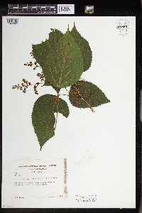 Laportea canadensis (L.) Weddell 961893[1340326] United States, Illinois |
MIN:Plants | 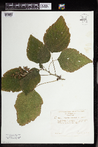 Laportea canadensis (L.) Weddell 961892[1340327] United States, Illinois |
MIN:Plants | 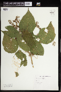 Laportea canadensis (L.) Weddell 961891[1340328] United States, South Dakota |
MIN:Plants | 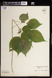 Laportea canadensis (L.) Weddell 961890[1340329] United States, Indiana |
MIN:Plants |  Laportea canadensis (L.) Weddell 965595[1371105]Sarah Dimick Gray 2021-07-25 United States, Minnesota, Anoka, Locke County Park, 45.0973739 -93.2545562, 255m |
MIN:Plants | Laportea canadensis (L.) Weddell []Timothy J. S. Whitfeld 33942022-07-18 United States, Minnesota, Washington, Crystal Spring Scientific and Natural Area, 0.4 miles northeast of the intersection of Scandia Trail North and Hwy 95, 45.25655 -92.764068, 228m |
MIN:Plants |  Laportea canadensis (L.) Weddell 970816[1394297]Smith, Welby R WRS357592017-07-09 United States, Minnesota, Anoka, Rice Creek Chain of Lakes Park Reserve. On a penninsula at the north end of George Watch Lake, about 3 km (1.9 miles) north of the approximate center of Centerville at a heading of 133 degrees., 45.1809167 -93.0831389 |
MIN:Plants |  Laportea canadensis (L.) Weddell 974561[1396925]Smith, Welby R WRS364192019-08-07 United States, Minnesota, McLeod, Liable Woods (Nature Conservancy preserve), about 4.8 km (3 miles) east of Biscay at a heading of 80 degrees., 44.834664 -94.215364 |
MIN:Plants |  Laportea canadensis (L.) Weddell 974653[1396983]Smith, Welby R WRS364482019-08-13 United States, Minnesota, Wright, Grass Lake State Wildlife Management Area, about 7 km (4.4 miles) southeast of the approximate center of Cokato at a heading of 142 degrees., 45.027775 -94.135255 |
MIN:Plants | 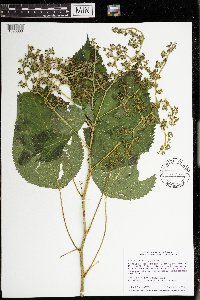 Laportea canadensis (L.) Weddell 974496[1396860]Smith, Welby R WRS365662019-09-14 United States, Minnesota, Dakota, Spring Lake Regional Park, about 10.4 km (6.5 miles) west of the Mississippi River Bridge in Hastings., 44.757208 -92.982797 |
MIN:Plants | 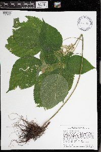 Laportea canadensis (L.) Weddell 976085[1373638]Smith, Welby R WRS367882020-08-05 United States, Minnesota, Wabasha, Upper Mississippi River National Fish and Wildlife Refuge, about 4.3 km (2.7 miles) due east of Kellogg., 44.31045 -91.94193 |
MIN:Plants | Boehmeria cylindrica (L.) Swartz 911007[]Smith, Welby 245781994-07-09 United States, Minnesota, Benton, Benton County...At the public access to Little Rock Lake; about two miles north of Watab...T 37N R 31W NE1/4 of NE1/4 of Sec 15. 037N 31W 15, 45.6133333 -93.82 |
MIN:Plants | Boehmeria cylindrica (L.) Swartz 908526[]Lee, Michael MDL41562005-09-08 United States, Minnesota, Benton, Benton County...Graham's Island in the Mississippi River at the State Hwy 15 bridge in Sartell / Sauk Rapids...T36N R31W SW1/4 of NE1/4 of NW1/4 sec. 22. 036N 31W 22, 45.598931 -94.181748 |
MIN:Plants | Boehmeria cylindrica (L.) Swartz 474221[]Moore, John 5481971-08-29 United States, Minnesota, Sherburne, SW1/4 S-32 Blue Hill Tshp. [Sherburne National Wildlife Refug];Sherburne National Wildlife Refuge;T035N R27W S32, 45.479795 -93.726179 |
MIN:Plants | Boehmeria cylindrica (L.) Swartz 479517[]Kaul, R.; et al. 61991988-08-05 United States, Minnesota, Steele, Steele County...along the Straight River just upstream from Morehouse Park.;;107N;20W;, 44.084579 -93.230139 |
MIN:Plants | Boehmeria cylindrica (L.) Swartz 270257[]Sandberg, John 1841889-06-00 United States, Minnesota, Hennepin, [no further data];;;;, 45 -93.47 |
MIN:Plants | Boehmeria cylindrica (L.) Swartz 345563[]Moyle, J. 30931937-10-01 United States, Minnesota, Hennepin, In Minnesota River Bottoms near the mouth of Nine Mile Creek;;N;;, 44.827152 -93.311782 |
MIN:Plants | Boehmeria cylindrica (L.) Swartz 372977[]Moore, John; et al. 146161941-07-05 United States, Minnesota, Wright, 1 mi NW of Annandale, Wright Co.;;121N;28W;, 45.28286 -94.19955 |
MIN:Plants | Boehmeria cylindrica (L.) Swartz 383714[]Moore, John 160501943-09-01 United States, Minnesota, Washington, Bank along the back water of the Mississippi river; NW1/4 Sec. 24 Cottage Grove Twp.;;027N;21W;34, 44.81525 -92.999127 |
MIN:Plants | Boehmeria cylindrica (L.) Swartz 430154[]Smith, Welby 139291987-09-01 United States, Minnesota, Scott, Scott Co. Murphy-Hanrahan Regional Park, about 2 mi W of Burnsville; SW1/4 NW1/4 sec.34, T115N R21W;Murphy-Hanrahan County Park Reserve;115N;21W;34, 44.727068 -93.336154 |
MIN:Plants | Boehmeria cylindrica (L.) Swartz 441820[]Lee, Michael MDL14201996-07-26 United States, Minnesota, Wabasha, Upper Mississippi National Wildlife Refuge. Wabasha County ... Mississippi River floodplain along Halfmoon Lake 1/2 mile south of West Newton ... on small island ... T109N R9W SE1/4 NW1/4 Sec. 9. 109N 09W 9, 44.257175 -91.899792 |
MIN:Plants | Boehmeria cylindrica (L.) Swartz 921194[]Lee, Michael MDL34602003-07-15 United States, Minnesota, Todd, Todd County...Along the Crow Wing River 1/2-mile downstrema from the Wadena County line, three miles east of downtown Staples...west side of the river...T133N R32W NE1/4 of SW1/4 Sec. 4. 133N 32W 4, 46.368148 -95.068781 |
MIN:Plants | Boehmeria cylindrica (L.) Swartz 509905[]Lee, Michael MDL23391998-08-04 United States, Minnesota, Wright, Wright County ... In old channel of Crow River 3-1/2 miles south-southwest of St. Michael ... T120N R24W NW1/4 of SE1/4 Sec. 35. 120N 24W 35, 45.080368 -93.740949 |
MIN:Plants | Boehmeria cylindrica (L.) Swartz 460350[]Mensing, D. 95-13681995-09-07 United States, Minnesota, Isanti, Isanti Co. T34N R23W SW1/4 of the SE1/4 of S21; floodplain of Cedar Creek;Cedar Creek National History Area;034N;23W;21, 45.415887 -93.21256 |
MIN:Plants | Boehmeria cylindrica (L.) Swartz 488757[]Moore, John; et al. 198791947-10-03 United States, Minnesota, Mower, At Horace Austin State Scenic Wayside Park;;;;, 43.66663 -92.974637 |
MIN:Plants | Boehmeria cylindrica (L.) Swartz 514321[]Smith, Welby 211701992-07-31 United States, Minnesota, Le Sueur, Le Sueur County ... at the S end of Fish Lake, about 2 miles N of Elysian ... T109N R24W SE1/4 of SE1/4 of Sec 23;;109N;24W;23, 44.2244453 -93.6699982 |
MIN:Plants | Boehmeria cylindrica (L.) Swartz 515548[]Smith, Welby 180761990-09-22 United States, Minnesota, Steele, Pogones Wildlife Management Area. Steele County ... Pogones State Wildlife Management Area, about 12 miles south-southeast of Owatonna ... T 105N R 19W NW1/4 of SE1/4 of Sec 18. 105N 19W 18, 43.8977776 -93.2783356 |
MIN:Plants | Boehmeria cylindrica (L.) Swartz 542460[]Moore, John; et al. 217831953-09-12 United States, Minnesota, Washington, Washington County ... Along the St. Croix River bank 1.5 mi N of Stillwater;Saint Croix National Riverway;030N;20W;, 45.078077 -92.806041 |
Google Map
Google Maps is a web mapping service provided by Google that features a map that users can pan (by dragging the mouse) and zoom (by using the mouse wheel). Collection points are displayed as colored markers that when clicked on, displays the full information for that collection. When multiple species are queried (separated by semi-colons), different colored markers denote each individual species.