University of Minnesota
http://www.umn.edu/
612-625-5000
http://www.umn.edu/
612-625-5000
Minnesota Biodiversity Atlas
Bell Museum
Dataset: MIN-Plants
Taxa: Urticaceae
Search Criteria: excluding cultivated/captive occurrences
Bell Museum plants | |
 MIN:Plants | Boehmeria cylindrica (L.) Swartz 566216[]Moore, John; Bernardini, J. 242461958-09-17 United States, Minnesota, Blue Earth, Along creek 3 mi W of Mankato;;N;;, 44.163533 -94.10035 |
MIN:Plants | Boehmeria cylindrica (L.) Swartz 583882[]Gunderson, R. 5691961-08-06 United States, Minnesota, Washington, St. Croix River, 3 mi N of Stillwater;Saint Croix National Riverway;030N;20W;, 45.09983 -92.80583 |
MIN:Plants | Boehmeria cylindrica (L.) Swartz 615905[]Moore, John; et al. 273221969-09-30 United States, Minnesota, Anoka, Anoka County...S of Cedar Bog Lake, Cedar Creek Natural History Area; Bethel Twp.;Cedar Creek National History Area;034N;23W;, 45.40217 -93.199397 |
MIN:Plants | Boehmeria cylindrica (L.) Swartz 681179[]Swanson, Steven 10281975-07-30 United States, Minnesota, Houston, Mississippi River (Navigation Pool #8). Houston Co, Site 71, N of a island, on the N 1/2 of island;Upper Mississippi National Wildlife Refuge;N;;, 43.575557 -91.264979 |
MIN:Plants | Boehmeria cylindrica (L.) Swartz 681577[]Swanson, Steven 15591975-07-17 United States, Minnesota, Houston, Mississippi River (Navigation Pool #8), Houston Co. Site 36;Upper Mississippi National Wildlife Refuge;N;;, 43.575557 -91.264979 |
MIN:Plants | Boehmeria cylindrica (L.) Swartz 681615[]Swanson, Steven 12891975-07-08 United States, Minnesota, Houston, Mississippi River (Navigation Pool #8). Houston Co, Site 74, island along main channel;Upper Mississippi National Wildlife Refuge;N;;, 43.575557 -91.264979 |
MIN:Plants | Boehmeria cylindrica (L.) Swartz 697912[]Ownbey, Gerald 55221976-09-10 United States, Minnesota, Dakota, Dakota Co. At bridge across the Vermillion River, rte 54 (91), Hastings, S side of hwy E of bridge; T115N R17W SE1/4 Sec Dakota Co. At bridge across the Vermillion River, rte 54 (91), Hastings, S side of hwy E of bridge; T115N R17W SE1/4 Sec. 27. 115N 17W 27, 44.735209 -92.838136 |
MIN:Plants | Boehmeria cylindrica (L.) Swartz 708222[]Ownbey, Gerald 64231979-09-07 United States, Minnesota, Washington, Washington County ... About 1.5 mi northeast of Stillwater, St. Croix River floodplain ... T30N R20W SE1/4 Sec. 15;Saint Croix National Riverway;030N;20W;15, 45.083773 -92.787583 |
MIN:Plants | Boehmeria cylindrica (L.) Swartz 709801[]Wheeler, Gerald 48161979-08-10 United States, Minnesota, Houston, Houston Co. Approx. 2 mi S of Reno on rte 26, adjacent to the Mississippi River; T101N R4W Sec. 2;Dorer Memorial Hardwood State Forest;101N;04W;2, 43.579834 -91.282915 |
MIN:Plants | Boehmeria cylindrica (L.) Swartz 709961[]Wheeler, Gerald 49901979-09-17 United States, Minnesota, Washington, Saint Croix National Riverway. Washington County ... About 4 mi NE of Stillwater on route 95, St. Croix River ... T30N R19W [should be R20] Sec 11 Sec. 11. 030N 20W 11, 45.100814 -92.771062 |
MIN:Plants | Boehmeria cylindrica (L.) Swartz 728639[]Wheeler, Gerald 53611980-07-18 United States, Minnesota, Ramsey, Roseville, Little Lake Josephine (between Lake Josephine and Lake Owasso), on the E side of the lake; T29N R23W Sec. 2;;029N;23W;2, 45.030163 -93.143669 |
MIN:Plants | Boehmeria cylindrica (L.) Swartz 729567[]Converse, C. 6001980-08-13 United States, Minnesota, Pine, Pine Co. St. Croix Natural Area, 21 mi E of Hinckley; SE1/4 NE1/4 Sec. 5 T40N R17W;Saint Croix State Park;040N;17W;5, 45.980424 -92.496049 |
MIN:Plants | Boehmeria cylindrica (L.) Swartz 729838[]Converse, C. 6501980-08-29 United States, Minnesota, Pine, Pine Co. Kettle River Natural Area, 5.5 mi E of Hinckley; NW1/4 SW1/4 Sec. 23 T41N R20W;Kettle River Scientific Natural Area / Sandstone National Wildlife Refuge;041N;20W;23, 46.01861 -92.8358 |
MIN:Plants | Boehmeria cylindrica (L.) Swartz 730286[]Phelps, V. 981980-08-19 United States, Minnesota, Chisago, Goose Creek Natural Area, 5 mi SE of Rush City, Goose Creek streamside; SE1/4 NW1/4 Sec. 24 T36N R21W;Wild River State Park;036N;21W;24, 45.595236 -92.911611 |
MIN:Plants | Boehmeria cylindrica (L.) Swartz 745398[]Smith, Welby 57031981-09-04 United States, Minnesota, Wright, Wright Co.; North Fork Crow River, at the co. hwy 4 crossing near Albright; NE1/4 SW1/4 Sec. 12 T119N R28W;;119N;28W;12, 45.131765 -94.000356 |
MIN:Plants | Boehmeria cylindrica (L.) Swartz 745401[]Smith, Welby 57511981-09-12 United States, Minnesota, Wright, Wright Co. Lake Marie State Park, about 1.5 mi E of Silver Creek; SW1/4 SW1/4 Sec. 121N R26W;Lake Maria State Park;121N;26W;3, 45.313964 -94.073115 |
MIN:Plants | Boehmeria cylindrica (L.) Swartz 745414[]Smith, Welby 56821981-09-04 United States, Minnesota, Wright, Wright Co. About 3.5 mi S of Montrose; SE1/4 NE1/4 Sec. 24 T118N R26W;;118N;26W;24, 45.015059 -93.892669 |
MIN:Plants | Boehmeria cylindrica (L.) Swartz 745415[]Smith, Welby 48901981-07-19 United States, Minnesota, Wright, Wright Co.; At the northeast end of a small unnamed lake in Hanover; NW1/4 SE1/4 Sec. 35 T 120N R 24W;;120N;24W;35, 45.156744 -93.673683 |
MIN:Plants | Boehmeria cylindrica (L.) Swartz 745444[]Smith, Welby 53711981-08-09 United States, Minnesota, Wright, Wright Co. On the S side of Lake Caroline, about 2 mi NNE of South Haven; NE1/4 SW1/4 Sec. 3 T121N R28W;;121N;28W;3, 45.316437 -94.197978 |
MIN:Plants | Boehmeria cylindrica (L.) Swartz 745469[]Smith, Welby 56971981-09-04 United States, Minnesota, Wright, Wright Co.; North Fork Crow River, at the co. hwy 3 crossing near French Lake; SW1/4 NW1/4 Sec. 22 T120N R28W;;120N;28W;22, 45.191575 -94.193286 |
MIN:Plants | Boehmeria cylindrica (L.) Swartz 747213[]Galatowitsch, S. 6941982-08-20 United States, Minnesota, Wabasha, Wabasha County...Weaver Dunes: T109N R9WSE1/4 and E1/2 NE1/4 of sec 7; NW1/4 and W1/2 NE1/4 of sec 8;Kellogg-Weaver Dunes Scientific Natural Area / Kellogg-Weaver Dunes, The Nature Conservancy;109N;09W;00, 44.258107 -91.938909 |
MIN:Plants | Boehmeria cylindrica (L.) Swartz 781046[]Smith, Welby 58561981-09-29 United States, Minnesota, Wright, Wright Co. On the E bank of the Clearwater River, about 1/4 mi S of its confluence with the Mississippi River; NW1/4 SW1 Wright Co. On the E bank of the Clearwater River, about 1/4 mi S of its confluence with the Mississippi River; NW1/4 SW1/4 Sec. 35 T123N R27W. 123N 27W 35, 45.423625 -94.052761 |
MIN:Plants | Boehmeria cylindrica (L.) Swartz 800271[]Cholewa, A.; et al. 17481989-07-14 United States, Minnesota, Washington, Carpenter Nature Center. Washington Co, T26N R20W S4...North ravine, near mouth of ravine;Carpenter Nature Center;026N;20W;04, 44.768259 -92.812758 |
MIN:Plants | Boehmeria cylindrica (L.) Swartz 817022[]Delaney, B. 890751989-07-07 United States, Minnesota, Isanti, 0.5 mi SW of Crown; SE1/4 NE1/4 Sec. 17 T34N R25W;;034N;25W;17, 45.43726 -93.473699 |
MIN:Plants | Boehmeria cylindrica (L.) Swartz 817575[]Delaney, B. 890841989-07-17 United States, Minnesota, Sherburne, 2.7 mi W, 0.3 mi S of downtown Zimmerman; SW1/4 NW1/4 Sec. 23 T34N R27W;;034N;27W;23, 45.423685 -93.670127 |
MIN:Plants | Boehmeria cylindrica (L.) Swartz 827550[]Almendinger, J.; et al. s.n.1989-07-10 United States, Minnesota, Anoka, Anoka County...SE of Linwood Lake. Carlos Avery Wildlife Mgmt Area. SE1/4 sec.17, T33N, R22W;Carlos Avery Wildlife Management Area;033N;22W;17, 45.347965 -93.113022 |
MIN:Plants | Boehmeria cylindrica (L.) Swartz 836035[]Smith, Welby 172541990-07-17 United States, Minnesota, Morrison, Camp Ripley Military Reservation. Camp Ripley Military Reservation. Morrison Co.; between East Boundary Road and the Mississippi River; UTM: 394800E 51077 Camp Ripley Military Reservation. Morrison Co.; between East Boundary Road and the Mississippi River; UTM: 394800E 5107700N T131N R30W SE1/4 of NW1/4 of Sec 32. 131N 30W 32, 46.114584 -94.484628 |
MIN:Plants | Boehmeria cylindrica (L.) Swartz 839285[]Smith, Welby 183401990-09-05 United States, Minnesota, Faribault, Pihls County Park. Faribault County ... Pihls County Park. On the W side of Rice Lake, about 6 mi S of Wells... T102N R24W SW1/4 of NW1/4 of Sec 16. 102N 24W 16, 43.6402779 -93.7258301 |
MIN:Plants | Boehmeria cylindrica (L.) Swartz 841557[]Smith, Welby 150931988-09-14 United States, Minnesota, Goodhue, Frontenac State Park. Goodhue County ... In Frontenac State Park, about 8 mi E-SE of Red Wing ... Mississippi River ... NE1/4 of NW1/4 sec.2, T112N R13W. 112N 13W 2, 44.5397224 -92.3399963 |
MIN:Plants | Boehmeria cylindrica (L.) Swartz 841619[]Smith, Welby 137601987-08-06 United States, Minnesota, Washington, Washington Co.; Island in Conoly Lake on the Mississippi River Bottoms, about 2 mi west of Point Douglas; SE1/4 SW1/4 sec.8, T 26N R 20W. 026N 20W 8, 44.747414 -92.835247 |
MIN:Plants | Boehmeria cylindrica (L.) Swartz 841700[]Smith, Welby 136621987-07-31 United States, Minnesota, Washington, Washington Co. On Upper Grey Cloud Island in the Mississippi River, about 3 mi S of St. Paul Park, NE1/4 NW1/4 sec.35, T Washington Co. On Upper Grey Cloud Island in the Mississippi River, about 3 mi S of St. Paul Park, NE1/4 NW1/4 sec.35, T27N R22W. 027N 22W 35, 44.785973 -93.007573 |
MIN:Plants | Boehmeria cylindrica (L.) Swartz 99705[]Aiton, G. s.n.1889-09-00 United States, Minnesota, Hennepin, [no further data];;;;, 45 -93.47 |
MIN:Plants | Boehmeria cylindrica (L.) Swartz 460122[]Myhre, K. 24371992-06-29 United States, Minnesota, Cass, Cass County...Located on the north bank of the Crow Wing River...T 133N R 29W SW1/4 of SW1/4 of sec 2;;133N;29W;29, 46.356523 -94.304037 |
MIN:Plants | Boehmeria cylindrica (L.) Swartz 920799[]Lee, Michael MDL34602003-07-15 United States, Minnesota, Todd, Todd County...Along the Crow Wing River 1/2-mile downstream from the Wadena County line, three miles east of downtown Staples...west side of the river...T133N R32W NE1/4 of SW1/4 Sec. 4. 133N 32W 4, 46.368148 -95.068781 |
MIN:Plants | Boehmeria cylindrica (L.) Swartz 910886[]Smith, Welby 244461994-06-21 United States, Minnesota, Isanti, Spectacle Lake Wildlife Management Area. Isanti County...Spectacle Lake State Wildlife Management Area; about 8 miles west of Cambridge...T 36N R 25W NW1/4 of SE1/4 of Sec 35. 036N 25W 35, 45.5611111 -93.4133333 |
MIN:Plants | Boehmeria cylindrica (L.) Swartz 473386[]Lee, Michael MDL18691997-07-23 United States, Minnesota, Stearns, Between Zimmer, Ketten, and Morden Lakes six miles southeast of Avon. SE1/4 of NW1/4 of NE1/4 of section;<No data>;124N;30W;25, 45.609131 -94.451667 |
MIN:Plants | Boehmeria cylindrica (L.) Swartz 475217[]Lee, Michael MDL16011996-09-20 United States, Minnesota, Kandiyohi, Kandiyohi County ... On narrow peninula of land between Kasota & Little Kandiyohi Lakes eight miles southeast of Willmar T119N R34W NE1/4 NE1/4 Sec. 36. 119N 34W 36, 45.073568 -94.890137 |
MIN:Plants | Boehmeria cylindrica (L.) Swartz 912782[]Lee, Michael; et al. MDL45182007-08-09 United States, Minnesota, Wadena, Wadena County...Along the Crow Wing River, 1/4-mile north of Bullard Bluff campsite, seven miles north of downtown north-northwest of downstream Staples...along small overflow channels on river floodplain just off the main Staples...T135N R33W W1/2 of NW1/4 of SW1/4 Sec. 36...UTM: 5146822N 361840E. 135N 33W 36, 46.497767 -94.799957 |
MIN:Plants | Boehmeria cylindrica (L.) Swartz 930987[]Smith, Welby R. 159021989-07-25 United States, Minnesota, Freeborn, At the public access on Freeborn Lake; about 4 miles north of Alden. NE1/4 of SW1/4 of section;Arrowhead Point County Park;103N;23W;11, 43.739831 -93.554765 |
MIN:Plants | Boehmeria cylindrica (L.) Swartz 936825[]Smith, Welby R. 297832006-08-09 United States, Minnesota, Martin, A marshy habitat at the south end of South Silver Lake, about 10 miles south of Fairmont. NW of NW of section;;101N;30W;32, 43.5123511 -94.4634429 |
MIN:Plants | 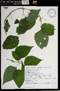 Boehmeria cylindrica (L.) Swartz 965598[1371102]Sarah Dimick Gray 9655982021-07-25 United States, Minnesota, Anoka, Locke County Park, 45.0973739 -93.2545562, 255m |
MIN:Plants | Boehmeria cylindrica (L.) Swartz MPCA_Dummy46[]Mark Gernes 2021-07-01 United States, Minnesota, Nicolet, Collected as part of the US Environmental Protection Agency National Wetland Condition Assessment (EPA siteID NWC21-MN-10019) and MN Pollution Control Agency MN Wetland Condition Assessment (MPCA siteID 21NICO019), 44.42643243 -93.94718632 |
MIN:Plants | 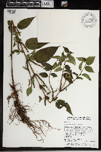 Boehmeria cylindrica (L.) Swartz 968162[1368801]Timothy J. S. Whitfeld 16292017-08-16 United States, Rhode Island, Washington, Frying Pan Pond, Wood River, 0.75 miles north-northwest of dam on Arcadia Road., 41.54914 -71.70397 |
MIN:Plants | 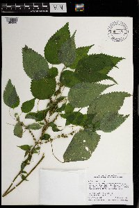 Boehmeria cylindrica (L.) Swartz 970878[1394346]Smith, Welby R WRS358172017-09-04 United States, Minnesota, Ramsey, On the east side of Sucker Lake in Shoreview., 45.072825 -93.0954861 |
MIN:Plants | 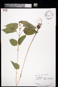 Boehmeria cylindrica (L.) Swartz 973713[1397268]Dunevitz, Hannah L. 11981996-07-09 United States, Minnesota, Rice, in the Cannon River Wilderness Area county park. On the west side of the Cannon River, 44.37 -93.22 |
MIN:Plants |  Boehmeria cylindrica (L.) Swartz 974635[1396965]Smith, Welby R WRS364152019-08-08 United States, Minnesota, McLeod, Liable Woods (Nature Conservancy preserve), about 5 km (3.1 miles) east of Biscay at a heading of 80 degrees., 44.835019 -94.213697 |
MIN:Plants |  Boehmeria cylindrica (L.) Swartz 976019[1373572]Smith, Welby R WRS367212020-06-23 United States, Minnesota, Dakota, Lake Rebecca Park; on the north side of Hastings just south of Lock and Dam #2 on the Mississippi River., 44.75391 -92.8702 |
MIN:Plants |  Boehmeria cylindrica (L.) Swartz 976099[1373652]Smith, Welby R WRS368252020-08-15 United States, Minnesota, Wright, On the northeast side of Pelican Lake, about 7 km (4.35 miles) southeast of the approximate center of Monticello., 45.252978 -93.748712 |
MIN:Plants |  Boehmeria cylindrica (L.) Swartz 975878[1373431]Smith, Welby R WRS368622020-08-19 United States, Minnesota, Ramsey, Snail Lake Regional Park in Shoreview. Along the shore of a shallow marshy bay of Grass Lake (west side)., 45.05717 -93.12055 |
MIN:Plants | Pilea fontana (Lunell) Rydberg 896530[]Rowe, Erika ERR20060907012006-09-07 United States, Minnesota, Becker, Becker County...East side of Rock Lake; west of Buffalo River; ~180 m north of NE Rock Lake Rd. ... NESW S21 T140NR40W;;140N;40W;21, 46.9247222 -95.7419444 |
MIN:Plants | Pilea fontana (Lunell) Rydberg 678991[]Gerdes, Lynden 52912006-08-10 United States, Minnesota, Itasca, Chippewa National Forest. T57N R26W S17NWSENE Itasca County ... Chippewa National Forest. Bowstring State Forest. Approximately 8.70 miles NE of Deer River, MN ... SE of Little Cottonwood Lake.. 057N 26W 17, 47.423566 -93.66588 |
MIN:Plants | Pilea fontana (Lunell) Rydberg 920619[]Smith, Welby 183811990-09-13 United States, Minnesota, Morrison, Camp Ripley Military Reservation. Camp Ripley Military Reservation. Morrison County...About 2 km NW of Crow Wing Lake...floodplain of the Mississippi River...UTM: 394500E 5122500N. T 132 R 29 SW1/4 of NW1/4 of Sec 17. 132N 29W 17, 46.2497222 -94.3686111 |
MIN:Plants | Pilea fontana (Lunell) Rydberg 903811[]Lee, Michael MDL41192005-08-26 United States, Minnesota, Becker, Becker County...Along the Straight River (Straight Lake Creek) 1/2 mile upstream from Straight Lake, 3.5 miles north-northwest of Osage...immediately upstream from a narrow township road (minimum maintenance) bridge crossing...T140N R36W SW1/4 of SE1/4 of NW1/4 Sec. 6. 140N 36W 6, 46.972841 -95.282007 |
MIN:Plants | Pilea fontana (Lunell) Rydberg 909927[]Lee, Michael MDL43082006-08-02 United States, Minnesota, Wadena, Wadena County...Along the Crow Wing River downstream from Knob Hill, 3.5 miles south of Oylen...T135N R33W SE1/4 of NW1/4 of NE1/4 Sec. 11...UTM: 5153962N 361443E. 135N 33W 11, 46.499962 -94.807535 |
MIN:Plants | Pilea fontana (Lunell) Rydberg 910767[]Smith, Welby 217211992-08-27 United States, Minnesota, Brown, Boesch Wildlife Management Area. Brown County...Boesch State Wildlife Management Area, about 3 miles northwest of New Ulm, in the Minnesota River Valley...T 110N R 31W SW1/4 of NW1/4 of Sec 3. 110N 31W 3, 44.3625 -94.5494444 |
MIN:Plants | Pilea fontana (Lunell) Rydberg 478342[]Lee, Michael MDL24511998-09-10 United States, Minnesota, Mille Lacs, Mille Lacs Kathio State Park. Mille Lacs County ... Mille Lacs - Kathio State Park. Rolling terrain along the south side of Tamarack Road three miles north-northeast of Onamia ... T42N R27W NE1/4 of NW1/4 Sec. 24. 042N 27W 24, 46.105618 -93.694119 |
MIN:Plants | Pilea fontana (Lunell) Rydberg 276049[]Grant, Martin 32851929-09-06 United States, Minnesota, Clearwater, Itasca Park, Morrison Lake, NW-SW-34, T143, R36;Itasca State Park;143N;36W;34, 47.159943 -95.222518 |
MIN:Plants | Pilea fontana (Lunell) Rydberg 366555[]Rosendahl, C. s.n.1939-08-00 United States, Minnesota, Clearwater, along Lake Side Trail, Itasca Park;Itasca State Park;143N;36W;, 47.197458 -95.201964 |
MIN:Plants | Pilea fontana (Lunell) Rydberg 370654[]Moore, John; Moore, Marjorie 136241940-09-28 United States, Minnesota, Ramsey, Ramsey Co.; [Round] lake, NE1/4 of S21, Moundsview Twp.;;030N;23W;21, 45.075793 -93.173251 |
MIN:Plants | Pilea fontana (Lunell) Rydberg 370706[]Moore, John; Moore, Marjorie 137191940-10-01 United States, Minnesota, Isanti, W shore of Lory Lake, Maple Ridge Twp;;037N;24W;, 45.721917 -93.362545 |
MIN:Plants | Pilea fontana (Lunell) Rydberg 373864[]Moore, John; et al. 151411941-09-19 United States, Minnesota, Dakota, 1 1/2 mi S of Nicols, Dakota Co.;;027N;23W;30, 44.79746 -93.21776 |
MIN:Plants | Pilea fontana (Lunell) Rydberg 385676[]Moyle, J. 39431945-08-29 United States, Minnesota, Winona, Winona Co, along Money Creek [near St. Charles or near Witoka?];;;;, 43.847304 -92.032671 |
MIN:Plants | Pilea fontana (Lunell) Rydberg 396825[]Stevens, O. 10591948-09-12 United States, Minnesota, Clay, just W of N.P. RR sta, Muskoda [historic RR station near Hawley];;139N;45W;17, 46.861627 -96.406734 |
MIN:Plants | Pilea fontana (Lunell) Rydberg 430156[]Smith, Welby 139231987-09-01 United States, Minnesota, Scott, Scott Co. Murphy-Hanrahan Regional Park, about 2 mi W of Burnsville; SW1/4 NW1/4 sec.34, T115N R21W;Murphy-Hanrahan County Park Reserve;115N;21W;34, 44.727068 -93.336154 |
MIN:Plants | Pilea fontana (Lunell) Rydberg 440745[]Smith, Welby 149911988-08-30 United States, Minnesota, Washington, Saint Croix National Riverway. Washington County ... About 2 mi NE of Stillwater ... on the W bank of the St. Croix River ... NE1/4 NW1/4 sec.14 T30N R20W. 030N 20W 14, 45.0922241 -92.7763901 |
MIN:Plants | Pilea fontana (Lunell) Rydberg 440815[]Smith, Welby 138481987-08-13 United States, Minnesota, Washington, Washington Co. Corries Swamp, about 8 mi NW of Marine on St. Croix; NW1/4 NE1/4 sec.35, T32N R21W;;032N;21W;35, 45.222682 -92.924742 |
MIN:Plants | Pilea fontana (Lunell) Rydberg 442221[]Moore, John; Huff, N. 190161946-08-13 United States, Minnesota, Stearns, W of Collegeville, Stearns Co.;;125N;29W;, 45.594409 -94.363053 |
MIN:Plants | Pilea fontana (Lunell) Rydberg 448356[]Moore, John; Huff, N. 189831946-08-07 United States, Minnesota, Clearwater, Peace Pipe Springs;Itasca State Park;143N;36W;, 47.195125 -95.225997 |
MIN:Plants | Pilea fontana (Lunell) Rydberg 448534[]Moore, John; Huff, N. 180941945-08-02 United States, Minnesota, Pine, Near the W bank of the St. Croix River, near the NE corner of St. Croix State Park;Saint Croix State Park;;;, 45.958273 -92.51719 |
MIN:Plants | Pilea fontana (Lunell) Rydberg 457055[]Boe, J.; et al. 940822051994-08-22 United States, Minnesota, Cass, Cass County...Nushka Lake...T145N R27W NE1/4 of SE1/4 of Sec 33;Chippewa National Forest / Leech Lake Indian Reservation;145N;27W;33, 47.331171 -94.097822 |
MIN:Plants | Pilea fontana (Lunell) Rydberg 457221[]Smith, Welby 211741992-07-31 United States, Minnesota, Le Sueur, Le Seur Co.; At the south end of Fish Lake, aobut 2 miles north of Elysian; T 109N R 24W SE1/4 of SE1/4 of Sec 23 Le Seur Co.; At the south end of Fish Lake, aobut 2 miles north of Elysian; T 109N R 24W SE1/4 of SE1/4 of Sec 23.. 109N 24W 23, 44.2272224 -93.6699982 |
MIN:Plants | Pilea fontana (Lunell) Rydberg 458822[]Smith, Welby 147171988-08-04 United States, Minnesota, Benton, Sartell Wildlife Management Area. Benton County...Sartell State Wildlife Management Area, about 2 miles northeast of Rice; along Little Rock Creek; SW1/4 SW1/4 sec.15, T 38N R 31W. 038N 31W 15, 45.792503 -94.19045 |
MIN:Plants | Pilea fontana (Lunell) Rydberg 475434[]Mensing, D. 95-10151995-08-04 United States, Minnesota, Clearwater, Clearwater Co. T144N R36W SW1/4 of the NE1/4 of S34; floodplain of the Mississippi River near the headwaters.;;144N;36W;34, 47.209387 -95.200297 |
MIN:Plants | Pilea fontana (Lunell) Rydberg 475435[]Schik, K. 96-1721996-09-09 United States, Minnesota, Brown, Brown Co. T110N R31W SE1/4 of the NW1/4 of S3; Floodplain forest of the Minnesota River;;110N;31W;3, 44.364033 -94.545489 |
MIN:Plants | Pilea fontana (Lunell) Rydberg 475436[]Mensing, D. 95-701995-09-08 United States, Minnesota, Chisago, Chisago Co. T36N R20W SE1/4 of the NW1/4 of S30; floodplain of Goose Creek;Wild River State Park;036N;20W;30, 45.58032 -92.89218 |
MIN:Plants | Pilea fontana (Lunell) Rydberg 475634[]Husveth, J. 96-2951996-09-05 United States, Minnesota, Hennepin, Hennepin Co. T119N R25W SE1/4 of the NE1/4 of S2 [this legal locality would be in Wright Co.?];;;;, 45.004576 -93.476884 |
MIN:Plants | Pilea fontana (Lunell) Rydberg 506769[]Smith, Welby 180711990-09-22 United States, Minnesota, Steele, Pogones Wildlife Management Area. Steele Co.; Pogones State Wildlife Management Area, about 12 mi S-SE of Owatonna; Steele Co.; Pogones State Wildlife Management Area, about 12 mi S-SE of Owatonna; T105N R19W NW1/4 of SE1/4 of Sec 18. 105N 19W 18, 43.8977776 -93.2783356 |
MIN:Plants | Pilea fontana (Lunell) Rydberg 514546[]Myhre, K. 31161992-08-17 United States, Minnesota, Cass, Crow Wing State Park. Cass Co.; located NE of the Crow Wing River and Crow Wing State Park; in the Crow Wing River floodplain; T133N R29W NW1/ Cass Co.; located NE of the Crow Wing River and Crow Wing State Park; in the Crow Wing River floodplain; T133N R29W NW1/4 of NW1/4 of Sec 33. 133N 29W 33, 46.294791 -94.346288 |
MIN:Plants | Pilea fontana (Lunell) Rydberg 518765[]Dana, R. 940161994-07-30 United States, Minnesota, Clay, Clay Co.; Haugtvedt Waterfowl Productiona Area; T137N R44W SE1/4 of SE1/4 of sEc 32;Haugtvedt Wildlife Management Area;137N;44W;32, 46.6311111 -96.257225 |
MIN:Plants | Pilea fontana (Lunell) Rydberg 518793[]Smith, Welby 148461988-08-12 United States, Minnesota, Washington, Belwin Outdoor Education Laboratory. Washington Co. Belwin Outdoor Education Laboratory, about 1/2 mile west of St. Mary's Point; (Trails End Marsh); NE1/4 NE1/4 sec. 15, T 28N R 20W. 028N 20W 15, 44.9213889 -92.7833333 |
MIN:Plants | Pilea fontana (Lunell) Rydberg 525690[]Lakela, Olga 194091955-08-31 United States, Minnesota, Saint Louis, shore of Floodwood River, above the dam at headwaters, hwy 73;;;;, 47.1667 -93.0333 |
MIN:Plants | Pilea fontana (Lunell) Rydberg 551210[]Cotter, Shirley 3199C1951-08-28 United States, Minnesota, Washington, S of Forest Lake;;;;, 45.265371 -92.954218 |
MIN:Plants | Pilea fontana (Lunell) Rydberg 566547[]Moore, John 243371958-10-06 United States, Minnesota, Blue Earth, point at Rapidan Lake;;;;, 44.091631 -94.108568 |
MIN:Plants | Pilea fontana (Lunell) Rydberg 574620[]Moore, John 247241959-07-29 United States, Minnesota, Kittson, below the dam at Bronson State Park;Lake Bronson State Park;161N;46W;, 48.735534 -96.662822 |
MIN:Plants | Pilea fontana (Lunell) Rydberg 615908[]Moore, John; Moore, Marjorie 273191969-09-30 United States, Minnesota, Anoka, S of Cedar Bog Lake, Bethel Twp, Cedar Creek Natural History Area;Cedar Creek National History Area;034N;23W;, 45.40217 -93.199397 |
MIN:Plants | Pilea fontana (Lunell) Rydberg 616790[]Moore, John; Moore, Marjorie 4841969-09-30 United States, Minnesota, Crow Wing, S end of Chandler Lake, SW1/4, S22, Garrison Twp;Crow Wing Natural Area;044N;28W;22, 46.278961 -93.86289 |
MIN:Plants | Pilea fontana (Lunell) Rydberg 704614[]Smith, Welby 16651979-08-16 United States, Minnesota, Wabasha, T109N, R9W; SE1/4 NW1/4 S18; 100 meters due W of co rd 84.;;109N;09W;18, 44.243599 -91.939111 |
MIN:Plants | Pilea fontana (Lunell) Rydberg 708440[]Ownbey, Gerald 64561979-09-13 United States, Minnesota, Washington, Washington County ... T 30 N, R 20 W, S14, NW1/4, 1.5 - 2.0 mi northeast of Stillwater;Saint Croix National Riverway;030N;20W;14, 45.091182 -92.778083 |
MIN:Plants | Pilea fontana (Lunell) Rydberg 722540[]Lustig, K. 10671979-08-31 United States, Minnesota, Anoka, 18 mi SE of Cambridge;Boot Lake Scientific Natural Area;033N;22W;, 45.34066 -93.08146 |
MIN:Plants | Pilea fontana (Lunell) Rydberg 722832[]Lustig, K. 9141979-08-13 United States, Minnesota, Anoka, 18 mi SE of Cambridge;Boot Lake Scientific Natural Area;033N;22W;, 45.34066 -93.08146 |
MIN:Plants | Pilea fontana (Lunell) Rydberg 728426[]Wheeler, Gerald 53861980-07-18 United States, Minnesota, Ramsey, Ramsey co.; Roseville. Little Lake Josephine (between Lake Josephine and Lake Owasso). E side of lake. T29N, R23W, S2;;029N;23W;2, 45.034228 -93.14839 |
MIN:Plants | Pilea fontana (Lunell) Rydberg 730413[]Phelps, V. 1331980-09-08 United States, Minnesota, Chisago, Goose Creek Natural Area: 5 mi SE of Rush City. NW1/4 NW1/4 S18, T36N, R21W;Wild River State Park;036N;21W;18, 45.612045 -93.017753 |
MIN:Plants | Pilea fontana (Lunell) Rydberg 730421[]Phelps, V. 1441980-08-25 United States, Minnesota, Chisago, Goose Creek Natural Area: 5 mi SE of Rush City. SE1/4 SE1/4 S12, T36N, R21W;Wild River State Park;036N;21W;12, 45.617568 -92.901538 |
MIN:Plants | Pilea fontana (Lunell) Rydberg 741273[]Converse, C. 21171982-08-25 United States, Minnesota, Pope, Moe Woods: T123N, R36W, SE1/4 SW1/4 S34.;Moe Woods, The Nature Conservancy;123N;36W;34, 45.41981 -95.183337 |
MIN:Plants | Pilea fontana (Lunell) Rydberg 741334[]Converse, C. 19791982-08-09 United States, Minnesota, Pope, Ordway Prairie: T123N, R36W, SE1/4 NE1/4 S30.;Ordway Prairie, The Nature Conservancy;123N;36W;30, 45.434262 -95.245019 |
MIN:Plants | Pilea fontana (Lunell) Rydberg 741585[]Converse, C. 19171982-07-29 United States, Minnesota, Pope, Ordway Prairie: T123N, R36W, NE1/4 NW1/4 S30.;Ordway Prairie, The Nature Conservancy;123N;36W;30, 45.434262 -95.245019 |
MIN:Plants | Pilea fontana (Lunell) Rydberg 758657[]Smith, Welby 69501982-07-29 United States, Minnesota, Mower, Cartney Wildlife Management Area. Cartney State Wildlife Management Area. About 5 mi NNW of LeRoy. Adjacent to the West Branch Little Iowa River. NW1/4 N Cartney State Wildlife Management Area. About 5 mi NNW of LeRoy. Adjacent to the West Branch Little Iowa River. NW1/4 NE1/4 S5, T101N, R14W. 101N 14W 5, 43.580049 -92.539234 |
MIN:Plants | Pilea fontana (Lunell) Rydberg 758969[]Smith, Welby 74251982-08-20 United States, Minnesota, Mower, Cartney Wildlife Management Area. Cartney State Wildlife Management Area. About 5 mi NNW of LeRoy. Adjacent to the West Branch Little Iowa River. NW1/4 N Cartney State Wildlife Management Area. About 5 mi NNW of LeRoy. Adjacent to the West Branch Little Iowa River. NW1/4 NE1/4 S5, T101N, R14W. 101N 14W 5, 43.580049 -92.539234 |
MIN:Plants | Pilea fontana (Lunell) Rydberg 759000[]Smith, Welby 73971982-08-20 United States, Minnesota, Mower, Brandt-Larson State Wildlife Management Area. About 4 mi NE of Lyle. Along Otter Creek. NE1/4 SW1/4 S16, T101N, R17W;Brandt-Larson Wildlife Management Area;101N;17W;16, 43.55122 -92.879061 |
MIN:Plants | Pilea fontana (Lunell) Rydberg 813559[]Wheeler, Gerald 119071988-08-19 United States, Minnesota, Norman, Ca 3 mi E of Fossum; about 0.7 mi W of Rte 40; W1/2 SW1/4 S35, T144N, R43W; (Fossum Twp);;144N;43W;35, 47.246072 -96.0989 |
Google Map
Google Maps is a web mapping service provided by Google that features a map that users can pan (by dragging the mouse) and zoom (by using the mouse wheel). Collection points are displayed as colored markers that when clicked on, displays the full information for that collection. When multiple species are queried (separated by semi-colons), different colored markers denote each individual species.