University of Minnesota
http://www.umn.edu/
612-625-5000
http://www.umn.edu/
612-625-5000
Minnesota Biodiversity Atlas
Bell Museum
Dataset: MIN-Plants
Taxa: Urticaceae
Search Criteria: excluding cultivated/captive occurrences
Bell Museum plants | |
 MIN:Plants | Pilea fontana (Lunell) Rydberg 816899[]Delaney, B. 893381989-09-05 United States, Minnesota, Sherburne, 2.2 mi E of Lake Fremont, SW1/4 NE1/4 S12, T34N, R26W;;034N;26W;12, 45.45306 -93.516983 |
MIN:Plants | Pilea fontana (Lunell) Rydberg 816969[]Delaney, B. 891891989-08-15 United States, Minnesota, Sherburne, 5 mi NNW of the city of Elk River, NE1/4 NE1/4 S8, T33N, R26W;;033N;26W;8, 45.369869 -93.595553 |
MIN:Plants | Pilea fontana (Lunell) Rydberg 834251[]Smith, Welby 198881991-07-31 United States, Minnesota, Todd, Todd Co. About 2 mi S of Grey Eagle, public access at the NW end of Big Birch Lake; Todd Co. About 2 mi S of Grey Eagle, public access at the NW end of Big Birch Lake; T127N R32W NE1/4 of SE1/4 of Sec 19.. 127N 32W 19, 45.7952766 -94.7508316 |
MIN:Plants | Pilea fontana (Lunell) Rydberg 836122[]Monson, Paul 46461964-08-23 United States, Minnesota, Mahnomen, Mahnomen Co. R-40, T-143, S-27; S side Hwy.113, 9.6 mi E of jnc. with Hwy.59;White Earth Indian Reservation / White Earth State Forest;143N;40W;27, 47.172265 -95.731915 |
MIN:Plants | Pilea fontana (Lunell) Rydberg 841729[]Smith, Welby 137131987-08-04 United States, Minnesota, Washington, Washington Co. About 7 mi W of Marine on St. Croix; NW1/4 SE1/4 sec.11, T31N R21W;;031N;21W;11, 45.1877785 -92.9208298 |
MIN:Plants | Pilea fontana (Lunell) Rydberg 842019[]Smith, Welby 150411988-09-06 United States, Minnesota, Washington, Washington Co. About 1 mi NE of Woodbury; NE1/4 SE1/4 sec.8, T28N R21W;;028N;21W;8, 44.9261093 -92.9472198 |
MIN:Plants | Pilea fontana (Lunell) Rydberg 99931[]Holzinger, John 641886-06-00 United States, Minnesota, Winona, Winona Co.;;;;, 43.98685 -91.779129 |
MIN:Plants | Pilea fontana (Lunell) Rydberg 475663[]Husveth, J. 95-17421995-09-04 United States, Minnesota, Goodhue, Goodhue Co, MN. T113N R15W SE1/4 of the NE1/4 of S19...along Cannon River;Dorer Memorial Hardwood State Forest;113N;15W;19, 44.578883 -92.662146 |
MIN:Plants | Pilea fontana (Lunell) Rydberg 816579[]Welling, C. 90106A1990-08-28 United States, Minnesota, Ramsey, Wetland immediately N of Minnesota State Hwy 96 and 0.6 km E of Hwy 61, Section 12 of White Bear Twp. Ramsey Co.;;030N;22W;12, 45.098474 -92.995672 |
MIN:Plants | Pilea fontana (Lunell) Rydberg 903830[]Lee, Michael MDL40892005-08-18 United States, Minnesota, Becker, Two Inlets State Forest. Becker County...north side of Two Inlets Lake, one mile southeast of Two Inlets...lower reaches of Dinner Creek, immediately upstream from the County Road 50 bridge...T141N R36W SW1/4 of NE1/4 of SE1/4 Sec.11. 141N 36W 11, 47.041131 -95.195423 |
MIN:Plants | Pilea fontana (Lunell) Rydberg 479430[]DeMink, L. 22182001-09-28 United States, Minnesota, Sherburne, Sherburne National Wildlife Refuge; SWNE 13-34-27;Sherburne National Wildlife Refuge;T034N R27W S13, 45.436474 -93.642941 |
MIN:Plants | Pilea fontana (Lunell) Rydberg 482421[]Lee, Michael; et al. MDL23791998-08-18 United States, Minnesota, Stearns, Stearns Co.; Six miles south of St. Augusta; T122N R28W SE1/4 of SE1/4 Sec. 12;;122N;28W;12, 45.391357 -94.148595 |
MIN:Plants | Pilea fontana (Lunell) Rydberg 510386[]Dziuk, P. PD 10162012-09-02 United States, Minnesota, Ramsey, Between asphalt path and Long Lake, approx. 60 yards Se of wood margin at swimming beach. SE1/4 NW1/4 of section;Long Lake Regional Park;030N;23W;20, 45.0738611 -93.1979861 |
MIN:Plants | Pilea fontana (Lunell) Rydberg 456207[]Rowe, Erika ERR1352005-09-09 United States, Minnesota, Becker, Tamarac National Wildlife Refuge. Becker County ... 0.3 miles west of County Hwy 35; 0.6 miles SW of Little Bemidji Lake on the northern border of Tamarac NWR ... 1/4SW 1/4SWW S26 T142N R39W. 142N 39W 26, 46.906743 -95.707484 |
MIN:Plants | Pilea fontana (Lunell) Rydberg 402199[]Anderson, Derek S. 23672014-08-28 United States, Minnesota, Polk, Dorr Wildlife Management Area, approximately 6.5km southwest of Erskine. South 4.5km on County Road 34, then west on County Road 41 about 3km. Continue additional 1.5km west on gravel road. T148N R43W NE 1/4 of NE 1/4 Sec. 24., 47.628787 -96.069975 |
MIN:Plants | 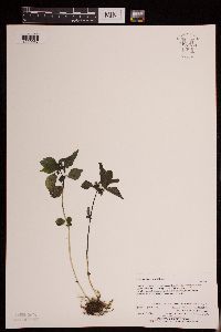 Pilea fontana (Lunell) Rydberg 950730[1290067]Perry, Ethan F. 140252014-08-15 United States, Minnesota, Saint Louis, T57N R16W NW1/4 of NE1/4 of Sec6; 3.1 miles southeast of Gilbert; about 100m south of Highway 97, 47.458065 -92.418166 |
MIN:Plants | 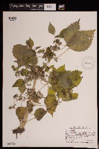 Pilea fontana (Lunell) Rydberg 945927[1291537]Smith, Welby R. WRS348492013-09-24 United States, Minnesota, Nicollet, On the south bank of the Minnesota River about 1.3 km (0.8 mile) south of Courtland. SW of SE of section; T109N R29W sec08, 44.2568833 -94.3406 |
MIN:Plants | 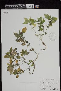 Pilea fontana (Lunell) Rydberg 943573[1297131]Smith, Welby R. 342772012-09-11 United States, Minnesota, Sibley |
MIN:Plants | 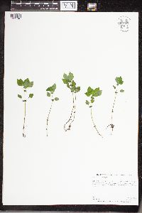 Pilea fontana (Lunell) Rydberg 960816[1329748]Perry, Ethan F. 180192018-08-07 United States, Minnesota, Koochiching, 5.9 miles northeast of Mizpah., 48 -94.15 |
MIN:Plants | 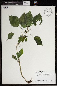 Pilea fontana (Lunell) Rydberg 966799[1359518]Anderson, Derek S. 27312017-08-22 United States, Minnesota, Wilkin, About 12.5 km southeast of Breckenridge on the Otter Tail River., 46.22 -96.43 |
MIN:Plants | Pilea fontana (Lunell) Rydberg []Bourdaghs, Michael 2022-09-08 United States, Minnesota, Isanti, Site ID: 16ISAN299; Visit Number: 2717, 45.70582788 -93.18432639 |
MIN:Plants | 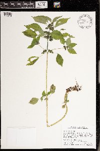 Pilea fontana (Lunell) Rydberg 976173[1373712]Smith, Welby R WRS368922020-08-22 United States, Minnesota, Anoka, Carlos Avery State Wildlife Management Area. At the control structure of pool 9, about 4.5 km (2.8 miles) W-SW of the town of Wyoming., 45.31981 -93.05747 |
MIN:Plants | 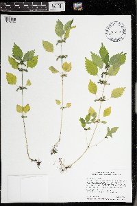 Pilea fontana (Lunell) Rydberg 976279[1373832]Smith, Welby R WRS369512020-08-28 United States, Minnesota, Ramsey, In a small shallow marsh along Rice Creek in Arden Hills., 45.106921 -93.184168 |
MIN:Plants | 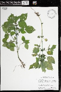 Pilea fontana (Lunell) Rydberg 976308[1373861]Smith, Welby R WRS369832020-09-05 United States, Minnesota, Ramsey, Tony Schmidt Regional Park in New Brighton., 45.0579 -93.17948 |
MIN:Plants | 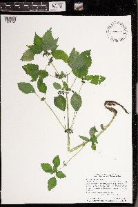 Pilea fontana (Lunell) Rydberg 976206[1373759]Smith, Welby R WRS370102020-09-09 United States, Minnesota, Dakota, Chub Lake State Wildlife Area. Specimen collected along Grenada Avenue where it crosses a narrow portion of Chub Lake, about 11 km (6.8 miles) south of Lakeville., 44.553703 -93.224567 |
MIN:Plants | 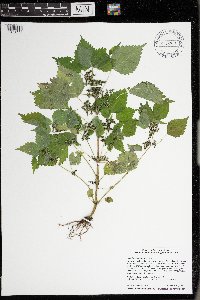 Pilea fontana (Lunell) Rydberg 976218[1373771]Smith, Welby R WRS370222020-09-10 United States, Minnesota, Goodhue, Specimen collected along a side channel of the Mississippi River about 8 km (5 miles) NW of the approximate center of Red Wing., 44.602758 -92.616747 |
MIN:Plants | 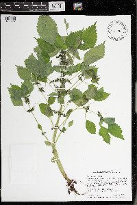 Pilea fontana (Lunell) Rydberg 976234[1373787]Smith, Welby R WRS370442020-09-15 United States, Minnesota, Dakota, Lake Rebecca Park; on the north side of Hastings just south of Lock and Dam #2 on the Mississippi River., 44.75391 -92.8702 |
MIN:Plants | Pilea pumila (L.) A. Gray 913991[]Smith, Welby 255351994-09-13 United States, Minnesota, Yellow Medicine, Upper Sioux Agency State Park, about 7 miles southwest of Sacred Heart; In the Minnesota Valley. SE1/4 of SE1/4 of section;Upper Sioux Agency State Park;115N;38W;29, 44.735 -95.4425 |
MIN:Plants | Pilea pumila (L.) A. Gray 912219[]Smith, Welby 216361992-08-26 United States, Minnesota, Nicollet, Seven Mile Creek County Park. Nicollet County.. In Seven Mile Creek County Park, about 7 miles north of Mankato...Seven Mile Creek...T109N R27W NW1/4 of NE1/4 of Sec 11. 109N 27W 11, 44.2680556 -94.0344444 |
MIN:Plants | Pilea pumila (L.) A. Gray 479211[]Kaul, R.; et al. 59931987-08-21 United States, Minnesota, Steele, Steele County...along Maple Creek at Mineral Springs;;107N;20W;, 44.094946 -93.228484 |
MIN:Plants | Pilea pumila (L.) A. Gray 479520[]Kaul, R. 62041988-08-06 United States, Minnesota, Rice, Rice Co.; Lake Mazaska;;111N;21W;, 44.354264 -93.296679 |
MIN:Plants | Pilea pumila (L.) A. Gray 511329[]Wheeler, Gerald 178111997-09-18 United States, Minnesota, Renville, Renville County ... Ca. 6 mi. SE of Franklin on rte. 5, S of road; County Park No. 4 ... SW1/4 SE1/4 Sec. 34 T112N R33W;Renville County Park #4;112N;33W;34, 44.464857 -94.792824 |
MIN:Plants | Pilea pumila (L.) A. Gray 436781[]McNaughton, Lynn 1402003-09-07 United States, Minnesota, Waseca, Maplewood Park: Waseca County ... SE1/4 of SW1/4 of Sect.9, T107N, R22W.;Maplewood County Park;107N;22W;09, 44.087663 -93.476763 |
MIN:Plants | Pilea pumila (L.) A. Gray 920342[]Smith, Welby 240271993-09-28 United States, Minnesota, Stearns, Partch Woods Scientific Natural Area. Stearns County ... Partch Woods State Scientific and Natural Area, about 3 miles south of St. Wendel ... T125N R29W SW1/4 of NE1/4 of Sec 19. 125N 29W 19, 45.625 -94.375 |
MIN:Plants | Pilea pumila (L.) A. Gray 281365[]Roberts, Thomas s.n.1878-08-05 United States, Minnesota, Hennepin, Lake Minnetonka;;;;, 44.917794 -93.610061 |
MIN:Plants | Pilea pumila (L.) A. Gray 334569[]Anonymous 991895-08-00 United States, Minnesota, Ramsey, St. Paul;;;;, 44.960694 -93.076799 |
MIN:Plants | Pilea pumila (L.) A. Gray 348385[]Buell, Murray; Buell, Helen 6241933-07-30 United States, Minnesota, Anoka, Decodon Pond;Cedar Creek National History Area;034N;23W;, 45.40217 -93.199397 |
MIN:Plants | Pilea pumila (L.) A. Gray 362651[]Butters, F.; Moore, John 135851940-09-18 United States, Minnesota, Chisago, 3 mi N of Taylors Falls;;;;, 45.445347 -92.652429 |
MIN:Plants | Pilea pumila (L.) A. Gray 367346[]Moore, John; Moore, Marjorie 105821938-09-17 United States, Minnesota, Fillmore, On hwy 74, ca. 4 mi N of Spring Valley, Fillmore Co.;;103N;13W;, 43.744847 -92.389059 |
MIN:Plants | Pilea pumila (L.) A. Gray 373999[]Linnaean Club, U of M, 2181940-10-13 United States, Minnesota, Rice, Nerstrand Woods, Rice Co, along stream below falls;Nerstrand Woods State Park;110N;19W;, 44.341172 -93.111247 |
MIN:Plants | Pilea pumila (L.) A. Gray 381349[]Moore, John; et al. 157101942-09-24 United States, Minnesota, Fillmore, 2.5 mi NW of Wykoff, Fillmore Co.;;103N;12W;, 43.722548 -92.289474 |
MIN:Plants | Pilea pumila (L.) A. Gray 383671[]Moore, John 160121943-08-25 United States, Minnesota, Winona, Winona Co.; Creek below Gwinn's Bluff;Great River Bluffs State Park;106N;05W;, 43.942065 -91.4667 |
MIN:Plants | Pilea pumila (L.) A. Gray 440169[]Smith, Welby 163611989-09-05 United States, Minnesota, Mille Lacs, Mille Lacs Co. About 11 mi N of Milaca; SW1/4 SE1/4 sec.26, T40N R27W;;040N;27W;26, 45.929793 -93.673183 |
MIN:Plants | Pilea pumila (L.) A. Gray 446763[]Moore, John; Huff, N. 192411946-09-11 United States, Minnesota, Renville, Joseph R. Brown State Park [historic site], Renville Co.;;114N;37W;5, 44.676446 -95.263858 |
MIN:Plants | Pilea pumila (L.) A. Gray 447667[]Husveth, J. 95-43161995-08-29 United States, Minnesota, Wabasha, Wabasha Co. T110N R11W SE1/4 of the SW1/4 of S22; Bank of the Zumbro River;Dorer Memorial Hardwood State Forest;110N;11W;22, 44.249964 -91.954363 |
MIN:Plants | Pilea pumila (L.) A. Gray 448408[]Moore, John; Huff, N. 189511946-08-03 United States, Minnesota, Benton, along the S bank of May Hew Creek, 5 mi E of East St. Cloud;;;;, 45.608364 -93.93811 |
MIN:Plants | Pilea pumila (L.) A. Gray 448661[]Moore, John; Huff, N. 193321946-10-03 United States, Minnesota, Jackson, along small creek at Kilen Woods State Park;Kilen Woods State Park;103N;35W;17, 43.72505 -95.064623 |
MIN:Plants | Pilea pumila (L.) A. Gray 457849[]Sandberg, John s.n.1889-09-00 United States, Minnesota, Hennepin, Hennepin Co.;;N;;, 45.004576 -93.476884 |
MIN:Plants | Pilea pumila (L.) A. Gray 475433[]Husveth, J. 95-32381995-09-04 United States, Minnesota, Goodhue, Goodhue Co. T113N R15W SE1/4 of the NE1/4 of S19; bank of the Cannon River adjacent to road construction.;Dorer Memorial Hardwood State Forest;113N;15W;19, 44.578883 -92.661746 |
MIN:Plants | Pilea pumila (L.) A. Gray 501643[]Stevens, O. 15171954-09-17 United States, Minnesota, Big Stone, Along stream, Ortonville;;N;;, 45.304687 -96.444779 |
MIN:Plants | Pilea pumila (L.) A. Gray 507390[]Moore, John 208971950-09-26 United States, Minnesota, Lincoln, Along the shore of Lake Shaokatan;;111N;46W;, 44.404779 -96.358106 |
MIN:Plants | Pilea pumila (L.) A. Gray 507425[]Moore, John 209111950-09-27 United States, Minnesota, Rock, Along Beaver Creek at Manley;;N;;, 43.592731 -96.429419 |
MIN:Plants | Pilea pumila (L.) A. Gray 526564[]Merrell, Ted s.n.1947-09-28 United States, Minnesota, Rice, Northfield, N of St. O;;;;, 44.458298 -93.161604 |
MIN:Plants | Pilea pumila (L.) A. Gray 542402[]Moore, John 214151951-10-10 United States, Minnesota, Steele, At Clinton Falls;;N;;, 44.138852 -93.246879 |
MIN:Plants | Pilea pumila (L.) A. Gray 549840[]Moore, John 221011954-09-15 United States, Minnesota, Sherburne, Along the banks of the Mississippi River 3 mi SW of Clear Lake;;N;;, 45.412794 -94.017419 |
MIN:Plants | Pilea pumila (L.) A. Gray 550097[]Moore, John; et al. 223261954-09-23 United States, Minnesota, Lincoln, 1 mi W of Lake Benton;;109N;45W;, 44.24108 -96.26172 |
MIN:Plants | Pilea pumila (L.) A. Gray 554462[]Moore, John; Hsi, Yu-tseng [Eugene] 233261957-08-05 United States, Minnesota, Blue Earth, On S shore of Lake George;;N;;, 44.233086 -93.870634 |
MIN:Plants | Pilea pumila (L.) A. Gray 558258[]Moore, John 236191957-09-24 United States, Minnesota, Clay, Along the Wild Rice River at Ulen;;N;;, 47.07885 -96.258949 |
MIN:Plants | Pilea pumila (L.) A. Gray 57012[]Wheeler, William 3271899-07-11 United States, Minnesota, Houston, Crooked Creek, Houston Co.;Dorer Memorial Hardwood State Forest;;;, 43.592621 -91.284352 |
MIN:Plants | Pilea pumila (L.) A. Gray 585898[]Stevens, O. 26851963-09-05 United States, Minnesota, Clay, along river, Buffalo River State Park;Buffalo River State Park;139N;46W;10, 46.86404 -96.46709 |
MIN:Plants | Pilea pumila (L.) A. Gray 585901[]Stevens, O. 26741963-08-10 United States, Minnesota, Clay, S of headquarters, Buffalo River State Park;Buffalo River State Park;139N;46W;10, 46.863699 -96.472855 |
MIN:Plants | Pilea pumila (L.) A. Gray 888832[]Stevens, O. 27571964-09-03 United States, Minnesota, Clay, [no further data];Buffalo River State Park;139N;46W;10, 46.863699 -96.472855 |
MIN:Plants | Pilea pumila (L.) A. Gray 598480[]Lee, Michael MDL15931996-09-19 United States, Minnesota, Kandiyohi, Sibley State Park. Kandiyohi Co.; Sibley State Park. Seven miles WNW of New London; between Swan & Middle Lakes; T121N R35W SW1/4 NE1/4 Sec Kandiyohi Co.; Sibley State Park. Seven miles WNW of New London; between Swan & Middle Lakes; T121N R35W SW1/4 NE1/4 Sec. 4. 121N 35W 4, 45.318501 -95.081073 |
MIN:Plants | Pilea pumila (L.) A. Gray 611441[]Lammers, Roberta s.n.1967-08-02 United States, Minnesota, Anoka, SW of Cedar Bog Lake, Cedar Creek Natural History Area;Cedar Creek National History Area;034N;23W;, 45.40217 -93.199397 |
MIN:Plants | Pilea pumila (L.) A. Gray 657099[]Scanlan, M. 2441973-09-13 United States, Minnesota, Big Stone, Collected in BI-284 (Sec. 10 T122N R47W) a ravine with an intermittent stream;;122N;47W;10, 45.391851 -96.544248 |
MIN:Plants | Pilea pumila (L.) A. Gray 681949[]Clemants, Steven 9081977-09-01 United States, Minnesota, Olmsted, Olmsted Co. Simpson's bluff, 4.5 mi S of town of Simpson on Co Rd 1. North Branch Root River. T105N, R13W, S20 E1/2;Dorer Memorial Hardwood State Forest;105N;13W;20, 43.88118 -92.404217 |
MIN:Plants | Pilea pumila (L.) A. Gray 687671[]Wheeler, Gerald; Glaser, Paul 21171977-07-17 United States, Minnesota, Itasca, Coll. site no 123. SE1/4 SW1/4 S25, T54N, R25W; ca 7.5 mi SE of Grand Rapids;Golden Anniversary State Forest;054N;25W;25, 47.125674 -93.334695 |
MIN:Plants | Pilea pumila (L.) A. Gray 697765[]Ownbey, Gerald 53971976-08-29 United States, Minnesota, Washington, Washington Co.; T28N, R20W, SE1/4 S26 ca 1.3 mi SE of Afton village along St. Croix River where rr trestle crosses dry s Washington Co.; T28N, R20W, SE1/4 S26 ca 1.3 mi SE of Afton village along St. Croix River where rr trestle crosses dry stream bed. 028N 20W 26, 44.879215 -92.770494 |
MIN:Plants | Pilea pumila (L.) A. Gray 708243[]Ownbey, Gerald 63291979-08-10 United States, Minnesota, Wabasha, Wabasha Co.; U.S. Rte 61, 1.8 mi W of Maple Springs, ca. 2 mi SE of jnc co. #4 with U.S. 61, at Lake City; T111N R12W Se Wabasha Co.; U.S. Rte 61, 1.8 mi W of Maple Springs, ca. 2 mi SE of jnc co. #4 with U.S. 61, at Lake City; T111N R12W Sec. 13 SW1/4. 111N 12W 13, 44.417673 -92.199332 |
MIN:Plants | Pilea pumila (L.) A. Gray 708371[]Ownbey, Gerald 65161979-09-16 United States, Minnesota, Rice, Co. rt. 20, ca. 2.5 mi S of Dundas. Park along Cannon River, E side. Sec. SW1/4;Cannon River Wilderness Park;111N;20W;26, 44.389825 -93.200024 |
MIN:Plants | Pilea pumila (L.) A. Gray 708381[]Ownbey, Gerald 65481979-09-17 United States, Minnesota, Washington, Washington Co.; T32N, R19, S31, NE1/4. Wm. O'Bien State Park along St. Croix River.;William O'Brien State Park;032N;19W;31, 45.220499 -92.758661 |
MIN:Plants | Pilea pumila (L.) A. Gray 708425[]Ownbey, Gerald 6443b1979-09-07 United States, Minnesota, Washington, Washington County ... T 30 N, R 20 W, Sec. 15, SE1/4 about 1.5 mi northeast of Stillwater ... St. Croix River;Saint Croix National Riverway;030N;20W;15, 45.083591 -92.788613 |
MIN:Plants | Pilea pumila (L.) A. Gray 708429[]Ownbey, Gerald 6443a1979-09-07 United States, Minnesota, Washington, Washington County ... T 30 N, R 20 W, Sec. 15, SE1/4 about 1.5 mi northeast of Stillwater ... St. Croix River;Saint Croix National Riverway;030N;20W;15, 45.083591 -92.788613 |
MIN:Plants | Pilea pumila (L.) A. Gray 711627[]Smith, Welby 15801979-08-28 United States, Minnesota, Goodhue, T112N, R13W; NW1/4 NE1/4 S7; 2.5 mi NW of Frontenac;;112N;13W;7, 44.520177 -92.419923 |
MIN:Plants | Pilea pumila (L.) A. Gray 711660[]Smith, Welby 17381979-08-30 United States, Minnesota, Dakota, T115N, R17W; NW1/4 S35; Within the municipal boundaries of Hastings. Just S of hwy 54 and W of hwy 91;;115N;17W;35, 44.743301 -92.852427 |
MIN:Plants | Pilea pumila (L.) A. Gray 723794[]Smith, Welby 36691980-09-08 United States, Minnesota, Wright, Wright Co. S bank of the North Fork Crow River, 1/2 mi SW of jnc st. hwy 25 and co. hwy 115; T119N R25W NE1/4 NE1/4 Sec. Wright Co. S bank of the North Fork Crow River, 1/2 mi SW of jnc st. hwy 25 and co. hwy 115; T119N R25W NE1/4 NE1/4 Sec. 30. 119N 25W 30, 45.087909 -93.764385 |
MIN:Plants | Pilea pumila (L.) A. Gray 723800[]Smith, Welby 36831980-09-09 United States, Minnesota, Wright, Wright Co.; on E bank of North Fork Crow River at crossing of co. rd 3, ca. 1/2 mi S of French Lake; T120N R28W NE1/4 SW Wright Co.; on E bank of North Fork Crow River at crossing of co. rd 3, ca. 1/2 mi S of French Lake; T120N R28W NE1/4 SW1/4 Sec. 22. 120N 28W 22, 45.191877 -94.187536 |
MIN:Plants | Pilea pumila (L.) A. Gray 729580[]Cutler, S. 1741980-08-07 United States, Minnesota, Pine, Pine Co. St. Croix Natural Area: 21 mi E of Hinckley, NE1/4 SW1/4 S4, T40N, R17W;Saint Croix State Park;040N;17W;4, 45.978993 -92.477277 |
MIN:Plants | Pilea pumila (L.) A. Gray 729915[]Converse, C. 5561980-07-23 United States, Minnesota, Pine, Pine Co. Kettle River Natural Area: 5.5 mi E of Hinckley, NW1/4 SW1/4 S23, T41N, R20W;Kettle River Scientific Natural Area / Sandstone National Wildlife Refuge;041N;20W;23, 46.013408 -92.841832 |
MIN:Plants | Pilea pumila (L.) A. Gray 730282[]Phelps, V. 1021980-08-19 United States, Minnesota, Chisago, Goose Creek Natural Area, 5 mi SE of Rush City, near Goose Creek-Black Ash swamp; SE1/4 NW1/4 Sec. 24 T36N R21W;Wild River State Park;036N;21W;24, 45.594996 -92.911783 |
MIN:Plants | Pilea pumila (L.) A. Gray 743896[]Ownbey, Gerald 66661980-09-20 United States, Minnesota, Houston, Twin Bluffs, 1.8 mi N of Iowa line at New Albin, E of bluffs;Dorer Memorial Hardwood State Forest;101N;04W;, 43.52775 -91.283745 |
MIN:Plants | Pilea pumila (L.) A. Gray 744986[]Smith, Welby 54111981-08-13 United States, Minnesota, Wright, Wright Co.; near the SW shore of Schmidt Lake; NW1/4 SE1/4 Sec. 25 T120N R25W;M Schmidt Crawford Woods Scientific Natural Area;120N;25W;25, 45.171303 -93.773325 |
MIN:Plants | Pilea pumila (L.) A. Gray 745442[]Smith, Welby 56851981-09-04 United States, Minnesota, Wright, Wright Co.; about 3.5 mi S of Montrose; SE1/4 NE1/4 Sec. 24 T118N R26W;;118N;26W;24, 45.015484 -93.892497 |
MIN:Plants | Pilea pumila (L.) A. Gray 745470[]Smith, Welby 56961981-09-04 United States, Minnesota, Wright, Wright Co.; floodplain of North Fork Crow River, about 1/4 mi W of the Co Hwy 7 crossing at Highland, T119N, R27W; NE1/4 Wright Co.; floodplain of North Fork Crow River, about 1/4 mi W of the Co Hwy 7 crossing at Highland, T119N, R27W; NE1/4 SE1/4 S11. T119N R27W S11, 45.131765 -94.000356 |
MIN:Plants | Pilea pumila (L.) A. Gray 747018[]Galatowitsch, S. 8221982-09-12 United States, Minnesota, Houston, Caledonia Oaks; T102N R5W E1/2 SW1/4 Sec. 24;Caledonia Oaks, The Nature Conservancy;102N;05W;24, 43.623103 -91.382423 |
MIN:Plants | Pilea pumila (L.) A. Gray 764359[]Taylor, B. s.n.1892-08-00 United States, Minnesota, Chisago, Center City;;;;, 45.389814 -92.821151 |
MIN:Plants | Pilea pumila (L.) A. Gray 778294[]Duxbury, Alexis 21541983-08-12 United States, Minnesota, Redwood, Redwood Co. Wahpeton Prairie; S1/2 NW1/4 Sec. 29 T110N R38W;Wahpeton Prairie, The Nature Conservancy;110N;38W;29, 44.304783 -95.440814 |
MIN:Plants | Pilea pumila (L.) A. Gray 782474[]Tenney, M. 5191982-08-10 United States, Minnesota, Winona, Whitewater State Park, Winona Co, T107N, R10W, S19, SW1/4 SE1/4 NW1/4;Whitewater State Park;107N;10W;19, 44.056381 -92.069193 |
MIN:Plants | Pilea pumila (L.) A. Gray 799190[]Almendinger, J. MCBS-91988-09-30 United States, Minnesota, Washington, Washington Co.; Hastings, T27N, R20W, N1/2 SE1/4 of Sec 33; along creek bottom ca 2 mi N Point Douglas;;027N;20W;33, 44.781931 -92.806909 |
MIN:Plants | Pilea pumila (L.) A. Gray 800292[]Cholewa, A.; et al. 17851989-08-30 United States, Minnesota, Washington, Carpenter Nature Center, Washington Co, T26N, R20W, S4...North Ravine at waterfall;Carpenter Nature Center;026N;20W;04, 44.768807 -92.813616 |
MIN:Plants | Pilea pumila (L.) A. Gray 813033[]Wheeler, Gerald 121591988-09-11 United States, Minnesota, Traverse, Traverse Co.; Browns Valley (NE side); W of Rte 2. NW1/4 NW1/4 S34, T125N, R49W (Folsom Twp);;125N;49W;34, 45.595226 -96.833504 |
MIN:Plants | Pilea pumila (L.) A. Gray 814156[]Wheeler, Gerald 123241988-09-24 United States, Minnesota, Lac Qui Parle, Lac Qui Parle Wildlife Management Area. Lac Qui Parle Co.; ca 6 mi NNE of Bellingham; Lac Qui Parle WMA, bordering the Minnesota River, N1/2 S12, T120N, R45W (A Lac Qui Parle Co.; ca 6 mi NNE of Bellingham; Lac Qui Parle WMA, bordering the Minnesota River, N1/2 S12, T120N, R45W (Agassiz Twp). 120N 45W 12, 45.217486 -96.237154 |
MIN:Plants | Pilea pumila (L.) A. Gray 815783[]Wheeler, Gerald 119931988-09-02 United States, Minnesota, Wilkin, Wilkin Co.; Breckenridge (W side); Welles Memorial Park, along Otter Tail River. NW1/4 S9, T132N, R47W (Breckenridge Twp Wilkin Co.; Breckenridge (W side); Welles Memorial Park, along Otter Tail River. NW1/4 S9, T132N, R47W (Breckenridge Twp). 132N 47W 9, 46.2567 -96.594353 |
MIN:Plants | Pilea pumila (L.) A. Gray 815897[]Wheeler, Gerald 119651988-08-21 United States, Minnesota, Norman, Norman Co.; Ca. 1.5 mi N of Hendrum, W of rte 75, along Wild Rice River (S bank); S1/2 NW1/4 Sec. 18 T144N R48W (Hendrum Norman Co.; Ca. 1.5 mi N of Hendrum, W of rte 75, along Wild Rice River (S bank); S1/2 NW1/4 Sec. 18 T144N R48W (Hendrum Twp.). 144N 48W 18, 47.286488 -96.809298 |
MIN:Plants | Pilea pumila (L.) A. Gray 817182[]Delaney, B. 891321989-07-25 United States, Minnesota, Isanti, Isanti Co.; 2.5 mi N of downtown Cambridge, W side Hwy 65. SE1/4 NE1/4 S16, T36N, R23W;;036N;23W;16, 45.610974 -93.206332 |
MIN:Plants | Pilea pumila (L.) A. Gray 817772[]Delaney, B. 891251989-07-20 United States, Minnesota, Sherburne, Sherburne co.; Between Hidden and Thompson Lakes, NW of Big Lake; NE1/4 SE1/4 Sec. 11 T33N R28W;;033N;28W;11, 45.365093 -93.789016 |
MIN:Plants | Pilea pumila (L.) A. Gray 825680[]Vuke, G. 1111948-08-00 United States, Minnesota, Hubbard, Itasca State Park, off La Salle Trail;Itasca State Park;143N;35W;, 47.19592 -95.107697 |
MIN:Plants | Pilea pumila (L.) A. Gray 828546[]Delaney, B. 902321990-09-08 United States, Minnesota, Isanti, Isanti Co.; along Rum River on levee bank by small, isolated backwater wetland; about 4 mi W of Cambridge. SW1/4 NE1/4 N Isanti Co.; along Rum River on levee bank by small, isolated backwater wetland; about 4 mi W of Cambridge. SW1/4 NE1/4 NE1/4 sec.27, T36N, R24W. 036N 24W 27, 45.584617 -93.312959 |
MIN:Plants | Pilea pumila (L.) A. Gray 833415[]Juhnke, C. 3211991-09-09 United States, Minnesota, Fillmore, Forestville State Park. Fillmore Co. T102N R12W Sec.13 SW NW NE. Picnic area along Root River;Forestville State Park;102N;12W;13, 43.637724 -92.219269 |
MIN:Plants | Pilea pumila (L.) A. Gray 835453[]Myhre, K. 43971993-08-08 United States, Minnesota, Pine, Pine Co. Located 1 mi N of the town of Sandstone; T42N R20W SW1/4 of SW1/4 of Sec 3;Banning State Park;042N;20W;3, 46.150727 -92.855553 |
Google Map
Google Maps is a web mapping service provided by Google that features a map that users can pan (by dragging the mouse) and zoom (by using the mouse wheel). Collection points are displayed as colored markers that when clicked on, displays the full information for that collection. When multiple species are queried (separated by semi-colons), different colored markers denote each individual species.