University of Minnesota
http://www.umn.edu/
612-625-5000
http://www.umn.edu/
612-625-5000
Minnesota Biodiversity Atlas
Bell Museum
Dataset: MIN-Plants
Taxa: Quercus
Search Criteria: excluding cultivated/captive occurrences
Bell Museum plants | |
 MIN:Plants |  Quercus chrysolepis Liebmann 827806[1005462;1005461]Moyle, J. 42381947-09-29 United States, California, Los Angeles, Los Angeles Co, San Gabriel Mts, Big Rock Canyon;;;;, 34.12667 -118.08333 |
MIN:Plants |  Quercus ellipsoidalis E.J. Hill 511009[1004944]Smith, Welby 290442000-08-24 United States, Minnesota, Sherburne, Sherburne National Wildlife Refuge. Sherburne County ... Sherburne National Wildlife Refuge. Along the Mahnomen Trail on the north side if Rice Lake ... T 35N R 27W NW1/4 of NW1/4 of Sec 26. 035N 27W 26, 45.4980556 -93.6511111 |
MIN:Plants |  480630[1005366]Smith, Welby 289612000-08-10 United States, Minnesota, Aitkin, Aitkin County ... On north side of Co Hwy 2, 1.2 miles east of jct with State Hwy 65 in Pliny ... T45N R23W SE1/4 of SW1/4 of Sec 34. 045N 23W 34, 46.3333333 -93.2322222 |
MIN:Plants |  Quercus macrocarpa Michaux 918198[1005063]Smith, Welby 223491993-06-08 United States, Minnesota, Carver, Carver County...Carver Park Reserve; about 5 miles west of Chanhassen...T 116N R 24W SE1/4 of NE1/4 of Sec 11;Carver Park Reserve County Park;116N;24W;11, 44.8716667 -93.6644444 |
MIN:Plants | Quercus falcata Michaux 680235[]US Nat. Arboretum staff s.n.1975-09-08 United States, District of Columbia, US National Arboretum. Cultivated |
MIN:Plants |  477422[1005273]Lee, Michael MDL15871996-09-19 United States, Minnesota, Kandiyohi, Sibley State Park. Kandiyohi County ... Sibley State Park. 7 miles WNW of New London ... between Swan & Middle Lakes ... T121N R35W SW1/4 NE1/4 Sec. 4. 121N 35W 4, 45.3185 -95.08107 |
MIN:Plants |  Quercus ellipsoidalis E.J. Hill 904068[1004803]Smith, Welby 28317A1999-09-15 United States, Minnesota, Nicollet, Nicollet County ... New Ulm Quartzite Quarry. In the Minnesota Valley, about 2 miles SE of New Ulm ... T110N R30W NE1/4 of SW1/4 of Sec 35. 110N 30W 35, 44.2866667 -94.4033333 |
MIN:Plants |  Quercus macrocarpa Michaux 919982[1005244]Smith, Welby 221931993-05-25 United States, Minnesota, Meeker, Meeker County...On the south side of T.H. 12, about 2 miles southeast of Darwin...T119N R30W NW1/4 of SE1/4 of Sec 25;;119N;30W;25, 45.0872222 -94.3916667 |
MIN:Plants |  Quercus macrocarpa Michaux 907718[1005206]Smith, Welby 308592008-05-30 United States, Minnesota, Stevens, Stevens County...along the southwest shore of Long Lake, about 6 mi east of Morris...T 124 R 41 SE1/4 of SE1/4 of Sec 3;;124N;41W;03, 45.5738889 -95.7927778 |
MIN:Plants |  Quercus macrocarpa Michaux 920228[1005243]Smith, Welby 222151993-05-25 United States, Minnesota, McLeod, Piepenburg CP. McLeod County...Piepenberg County Park, on the east side of Belle Lake about 6 miles northwest of Hutchinson...T117N R 30W SE1/4 of NE1/4 of Sec 3. 117N 30W 3, 44.9736111 -94.4211111 |
MIN:Plants |  480892[1005333]Smith, Welby 250701994-08-12 United States, Minnesota, Steele, Steele County ... Kaplan Woods City Park, on the south side of Owatonna ... T 107N R 20W NE1/4 of NW1/4 of Sec 21. 107N 20W 21, 44.0644444 -93.235 |
MIN:Plants |  Quercus vaccinifolia Kellogg ex Curran 794799[1005474]Schaaf, J. 1391983-08-28 United States, California, Alpine, Alpine Co. ... Toiyabe Nat'l. Forest. Grover Hot Springs;;;;, 38.69556 -119.8425, 2438m |
MIN:Plants |  477288[1283128]Smith, Welby 291512001-05-11 United States, Minnesota, Wright, Wright County ... Harry Larson County Forest, about 7 miles W-NW of Monticello ... T 122N R 26W SW1/4 of SW1/4 of Sec 35;Harry Larson County Forest;122N;26W;35, 45.3352778 -93.9280556 |
MIN:Plants |  Quercus ellipsoidalis E.J. Hill 903334[1004794]Smith, Welby 290032000-08-17 United States, Minnesota, Anoka, Anoka County...In the City of Blaine, just south of 95th street, and east of I35W...T 31N R 23W SW1/4 of SW1/4 of Sec 26;;031N;23W;26, 45.14 -93.1713889 |
MIN:Plants | Quercus bicolor Willdenow 914306[1004740]Smith, Welby United States, Minnesota, Winona, Detailed locality information protected. This is typically done to protect rare or threatened species localities. |
MIN:Plants |  484310[1005388]Lee, Michael MDL25371999-07-06 United States, Minnesota, Lake, Lake County...two miles east-northeast of Finland...T57N R7W NW1/4 of NE1/4 of NW1/4 Sec. 15;North Shore;057N;07W;15, 47.42219 -91.2038 |
MIN:Plants |  Quercus macrocarpa Michaux 476672[1005127]Kaul, R.; et al. 29261984-05-18 United States, Minnesota, Rice, Rice County...south shore of Shield's Lake.;;110N;22W;, 44.32669 -93.46404 |
MIN:Plants |  471998[1005423]Smith, Welby 289692000-08-10 United States, Minnesota, Kanabec, Kanabec County...At the public access on the west side of Knife lake, just off Hwy 65...T41NR23WSE1/4 of SE1/4 Sec 32;;041N;23W;32, 45.9847222 -93.2783333 |
MIN:Plants |  Quercus macrocarpa Michaux 478078[1005141]Smith, Welby 254841994-09-08 United States, Minnesota, Polk, Polk County ... At Nancy Sather's farm, about 1.25 miles west of the Polk-Clearwater county line ... T 147N R 39W NE1/4 of SE1/4 of Sec 11. 147N 39W 11, 47.5633333 -95.5802778 |
MIN:Plants |  Quercus ellipsoidalis E.J. Hill 920236[1004977]Smith, Welby 222051993-05-25 United States, Minnesota, Meeker, Meeker County...On the south side of T.H. 12, about 2 miles southeast of Darwin...T119N R30W NW1/4 of SE1/4 of Sec 25;;119N;30W;25, 45.0872222 -94.3916667 |
MIN:Plants |  Quercus macrocarpa Michaux 477953[1005004]Smith, Welby 209211992-07-15 United States, Minnesota, Marshall, Old Mill State Park. Marshall County ... In Old Mill State Park, about 11 miles east of Argyle ... along the Middle River ... T 156N R 46W NW1/4 of SE1/4 of sec 4. 156N 46W 4, 48.3602778 -96.5702778 |
MIN:Plants |  Quercus ellipsoidalis E.J. Hill 477632[1004773]Smith, Welby 282251999-08-27 United States, Minnesota, Scott, Scott County ... Carver Rapids State Wayside, in the Minnesota Valley ... T 115N R 23W SE1/4 of NW1/4 of sec 32;Minnesota Valley State Park;115N;23W;32, 44.7286111 -93.6125 |
MIN:Plants |  511579[1005334]Smith, Welby 289922000-08-16 United States, Minnesota, Fillmore, Fillmore County ... Forestville State Park, about 3 miles SW of Carimona ... T 102N R11W SW1/4 of NW1/4 of Sec 18;Forestville State Park;102N;11W;18, 43.6402778 -92.2075 |
MIN:Plants |  916004[1096474]Smith, Welby 250701994-08-12 United States, Minnesota, Steele, Kaplan Woods City Park, on the south side of Owatonna. NE1/4 of NW1/4 of Sec;;107N;20W;21, 44.0644444 -93.235 |
MIN:Plants |  478118[1005374]Smith, Welby 289812000-08-15 United States, Minnesota, Washington, Afton State Park. Washington County ... Afton State Park; about 7 miles NE of Hastings ... bluff overlooking the St. Croix River ... T 27N R 20W NE1/4 of NW1/4 of Sec 11. 027N 20W 11, 44.846237 -92.773417 |
MIN:Plants |  Quercus macrocarpa Michaux 480857[1005073]Smith, Welby 289702000-08-13 United States, Minnesota, Wright, Harry Larson County Forest. Wright County ... In Harry Larson County Memorial Forest, about 3 miles northeast of Silver Creek ... T 122N R 26W SW1/4 of NW1/4 of Sec 35. 122N 26W 35, 45.3352778 -93.9266667 |
MIN:Plants |  Quercus macrocarpa Michaux 430184[1005252]Bright, R. 74-2391974-00-00 United States, Minnesota, Anoka, Coon Rapids;;;;, 45.12 -93.2875 |
MIN:Plants |  Quercus macrocarpa Michaux 426756[1005254]Juhnke, C. 177 CMJ FRO1999-05-05 United States, Minnesota, Goodhue, Frontenac State Park Goodhue County ... Along trail between prairie and woods to powerline prairie... T112N R13W NWNWSE2;Frontenac State Park;112N;13W;02, 44.53507 -92.33916 |
MIN:Plants |  Quercus ellipsoidalis E.J. Hill 489294[1004924]Smith, Welby 282221999-08-25 United States, Minnesota, Hubbard, Hubbard County ... At the north end of Long Lake, about 3 miles east of Park Rapids ...T 140N R 34W SE1/4 of NE1/4 of Sec 20. 140N 34W 20, 46.9291667 -94.9291667 |
MIN:Plants |  Quercus ellipsoidalis E.J. Hill 485022[1004796]Smith, Welby 276441999-05-02 United States, Minnesota, Chisago, Interstate State Park. Chisago County ... SE-facing bluff in Interstate State Park; about 1.5 miles SW of Taylor's Falls (town) ... T34N R 19W SE1/4 of SE1/4 of Sec 35. 034N 19W 35, 45.3866667 -92.6716667 |
MIN:Plants |  Quercus gambelii Nuttall 755945[1005466;1005465]Davis, Owen AZ76-111976-10-08 United States, Arizona, Coconino, Coconina Co, ca. 10 miles north of Sedona ... Oak Creek Canyon;;;;, 35.01479 -111.76028 |
MIN:Plants |  Quercus macrocarpa Michaux 124896[1005203]Smith, Welby 230661993-07-21 United States, Minnesota, McLeod, McLeod County... On the east side of Hook Lake, about 3 mi north of Hutchinson...between lake and County Road 61... T117N R29W SW1/4 of SW1/4 of Sec 9. 117N 29W 9, 44.9519444 -94.335 |
MIN:Plants |  905259[1005264]Gerdes, Lynden 45862002-08-01 United States, Minnesota, Lake, T56N R09W S21SWSE. Lake County...Approx. 21.35 miles NE of Two Harbors, MN and 1.75 miles ESE of Water Tank Lake.;Superior National Forest;056N;09W;21, 47.32152 -91.48422 |
MIN:Plants |  920238[1005263]Smith, Welby 222021993-05-25 United States, Minnesota, Meeker, Meeker County...On the south side of T.H. 12, about 2 miles southeast of Darwin...T119N R30W NW1/4 of SE1/4 of Sec 25;;119N;30W;25, 45.0872222 -94.3916667 |
MIN:Plants |  454137[1005335]Gerdes, Lynden 38882000-05-22 United States, Minnesota, Lake, Lake County ... Tettegouche State Park, Mt. Trudee ... T56N R07W S17SWNE;North Shore / Tettegouche State Park;056N;07W;17, 47.33614 -91.25087 |
MIN:Plants |  Quercus ellipsoidalis E.J. Hill 509627[1004943]Smith, Welby 275551998-08-28 United States, Minnesota, Wright, Wright County ... Lake Maria State Park, about 3 miles south-southwest of Hasty ... T121N R26W NE1/4 of NW1/4 of Sec 3;Lake Maria State Park;121N;26W;3, 45.3252792 -93.9430542 |
MIN:Plants |  Quercus ellipsoidalis E.J. Hill 454327[1004762]Smith, Welby 257971995-08-01 United States, Minnesota, Kandiyohi, Kandiyohi County ... Sibley State Park, about 5 miles west of New London ... T 121N R35W SW1/4 of NE1/4 of Sec 1;Sibley State Park;121N;35W;1, 45.3199997 -95.0161133 |
MIN:Plants |  Quercus macrocarpa Michaux 912878[1005119]Smith, Welby 240611994-05-10 United States, Minnesota, Yellow Medicine, Upper Sioux Agency State Park. Yellow Medicine County...Upper Sioux Agency State Park, about 7 miles southwest of Sacred Heart; in the Minnesota River Valley...T 115N R 38W SE1/4 of SE1/4 of Sec 29. 115N 38W 29, 44.735 -95.4425 |
MIN:Plants |  Quercus ellipsoidalis E.J. Hill 476673[1004767]Kaul, R. 27771983-08-11 United States, Minnesota, Hubbard, Hubbard Co.; One mile north of Park Rapids;;140N;35W;, 46.94745 -95.0592 |
MIN:Plants |  476907[1005346]Smith, Welby 290212000-08-22 United States, Minnesota, Pine, Saint Croix State Park. Pine County ... St. Croix State Park; where Sand Creek joins the St. Croix River ... T 40N R 18W SE1/4 of SW1/4 of Sec 19. 040N 18W 19, 45.9322205 -92.6399994 |
MIN:Plants |  Quercus maritima (Michaux) Willdenow 423259[1005468]Demaree, Delzie 283491949-08-23 United States, Mississippi, Harrison, P.O. Biloxi;;;;, 30.39583 -88.88528 |
MIN:Plants |  Quercus alba L. 508862[1004681]Smith, Welby 253931994-09-02 United States, Minnesota, Dodge, Vorce Wildlife Management Area. Dodge County ... Vorce State Wildlife Management Area, about 2 miles north-northeast of Claremont ... T 107N R 18W SE1/4 of SW1/4 of sec 15. 107N 18W 15, 44.0672226 -92.976387 |
MIN:Plants |  Quercus macrocarpa Michaux 898321[1005042]Smith, Welby 276431999-05-02 United States, Minnesota, Chisago, Interstate State Park. Chisago County...bluff in Interstate State Park; about 1.5 miles SW of Taylor's Falls...T34N R19W SE1/4 of SE1/4 of Sec 35. 034N 19W 35, 45.3866667 -92.6716667 |
MIN:Plants |  Quercus ellipsoidalis E.J. Hill 511517[1004942]Smith, Welby 290392000-08-23 United States, Minnesota, Rice, Rice County ... At the !35 north-bound rest stop, about 4 miles west of Dundas ... T 111N R 21W SE1/4 of SW1/4 of Sec 12;;111N;21W;12, 44.4308319 -93.2938919 |
MIN:Plants |  Quercus ellipsoidalis E.J. Hill 477805[1004831]Smith, Welby 289722000-08-13 United States, Minnesota, Wright, Harry Larson County Forest. Wright County ... In Harry Larson County Memorial Forest, about 3 miles northeast of Silver Creek ... T 122N R 26W SW1/4 of NW1/4 of Sec 35. 122N 26W 35, 45.3352776 -93.9266663 |
MIN:Plants |  Quercus macrocarpa Michaux 914179[1005211]Smith, Welby 225101993-06-18 United States, Minnesota, Douglas, Douglas County...Lake Carlos State Park, about 6 miles north of Alexandria...T 129N R 37W SE1/4 of SW1/4 of Sec 9;Lake Carlos State Park;129N;37W;09, 45.9958333 -95.3469444 |
MIN:Plants |  Quercus chrysolepis Liebmann 234531[1005463]Congdon, J. s.n.1890-06-01 United States, California, Mariposa, Snow Creek, Mariposa County;Yosemite National Park;;;, 37.48167 -119.87361, 1829m |
MIN:Plants | Quercus velutina Lamarck 430167[]Arboretum, Cary 73-341973-00-00 United States, New York, Dutchess, Dutchess Co. [cultivated ?] |
MIN:Plants |  Quercus alba L. 453874[1004695]Kaul, R.; et al. 27631983-07-14 United States, Minnesota, Rice, Rice County...Upper end of 14th St. ravine, along Shumway Avenue, Faribault.;;;;, 44.295 -93.26861 |
MIN:Plants |  482186[1005267]Wheeler, Gerald 160131997-06-09 United States, Minnesota, Brown, Brown Co.; Ca. 2.3 mi. NW of Rte. 13, NW of New Ulm; N1/2 NW1/4 SW1/4 Sec. 3 T110N R31W (Milford 3);;110N;31W;3, 44.36071 -94.54311 |
MIN:Plants |  Quercus macrocarpa Michaux 480856[1005213;1005212]Smith, Welby 290102000-08-18 United States, Minnesota, Winona, Whitewater Wildlife Management Area. Winona County ... Whitewater State Wildlife Management Area, about 5 miles SW of Weaver ... T 108N R 10W NE1/4 of NE1/4 of Sec 15. 108N 10W 15, 44.1597214 -92.0027771 |
MIN:Plants |  Quercus macrocarpa Michaux 461994[1005106]Smith, Welby 289932000-08-16 United States, Minnesota, Fillmore, Fillmore county ... Forestville State Park, about 3 mile SW of Carimona ... T102N R11W SW1/4 of NW1/4 of Sec 18;Forestville State Park;102N;11W;18, 43.6402779 -92.2074966 |
MIN:Plants |  Quercus alba L. 509655[1004683]Smith, Welby 289752000-08-14 United States, Minnesota, Ramsey, Ramsey County ... Battle Creek County Park, in St. Paul ... T 28N R 22W SE1/4 of SE1/4 of Sec 3;;028N;22W;03, 44.9361111 -93.0280556 |
MIN:Plants |  Quercus ellipsoidalis E.J. Hill 427093[1004931]Smith, Welby 275401998-08-18 United States, Minnesota, Pine, General C C Andrews State Forest. Pine County ... In General C.C. Andrews State Forest, about 3 miles east of Willow River (town) ... T44N R19W NW1/4 of SW1/4 of Sec 5. 044N 19W 5, 46.3213882 -92.7819443 |
MIN:Plants |  Quercus macrocarpa Michaux 912455[1005204]Smith, Welby 253601994-09-02 United States, Minnesota, Dodge, Dodge County...Dodge Center Creek City Park, about 1.5 miles west-northwest of Dodge Center...Dodge Center Creek... T107N R17W SW1/4 of SW1/4 of Sec 28. 107N 17W 28, 44.0405556 -92.8780556 |
MIN:Plants | 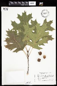 Quercus velutina Lamarck 462015[1005428]Smith, Welby 255741994-09-27 United States, Minnesota, Winona, In the Mississippi river bottoms about 0.75 mile N-NW of Minnesota City, on the east side of U.S. Hwy 61. NW1/4 o NW1/4 of section;Upper Mississippi National Wildlife Refuge;107N;08W;02, 44.1055556 -91.755 |
MIN:Plants | Quercus chenii Nakai 680261[]US Nat. Arboretum staff PI1206531975-09-08 United States, District of Columbia, US National Arboretum. Cultivated |
MIN:Plants | 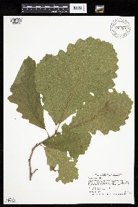 Quercus macrocarpa Michaux 909218[1005050]Smith, Welby 218641992-09-03 United States, Minnesota, Watonwan, Watonwan County...At the public access on the north side of Fedji Lake, about 2 miles northeast of Madelia...T 107N R 30W SW1/4 of SW1/4 of Sec 12. 107N 30W 12, 44.0816667 -94.3880556 |
MIN:Plants | 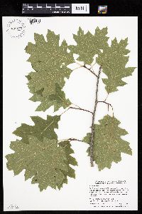 899125[1005268]Smith, Welby 273651998-07-10 United States, Minnesota, Otter Tail, Bluff Creek Wildlife Management Area. Otter Tail County...Bluff Creek State Wildlife Management Area, about 11 miles west of Sebeka...T136N R37W NE1/4 of NW1/4 of Sec 2. 136N 37W 2, 46.6286111 -95.3144444 |
MIN:Plants | 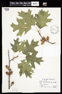 Quercus ellipsoidalis E.J. Hill 488790[1004945]Smith, Welby 264181996-09-11 United States, Minnesota, Wadena, Wadena County ... About 5 miles southeast of Nimrod, on the north side of County Road 139 ... T 136N R33W SW1/4 of SE1/4 of Sec 1. 136N 33W 1, 46.6188889 -94.788887 |
MIN:Plants |  Quercus alba L. 453892[1004720]Kaul, R.; et al. 29241984-05-18 United States, Minnesota, Rice, Rice County...Along Shumway Avenue, Faribault, near the ravine at 14th St.;;;;, 44.295 -93.26861 |
MIN:Plants |  Quercus borealis Michx. 484633[1005345]Kaul, Robert B. 29201984-05-18 United States, Minnesota, Steele, at Mineral Springs, Owatonna [T107N;R20W], 44.08389 -93.22583 |
MIN:Plants |  454824[1005269]Smith, Welby 290122000-08-18 United States, Minnesota, Winona, Whitewater Wildlife Management Area. Winona County ... Whitewater State Wildlife Management Area; about 5 miles SW of Weaver ... T108N R10W NE1/4 of NE1/4 of Sec 15. 108N 10W 15, 44.1597214 -92.0027771 |
MIN:Plants |  Quercus ellipsoidalis E.J. Hill 429354[1004763]Smith, Welby 267861997-08-13 United States, Minnesota, Saint Louis, Voyageurs National Park. St. Louis County ... Voyageurs National Park. On the trail to Cruiser Lake from Lost Bay of Kabetogama Lake ...T69N R19W SE1/4 of SW1/4 of Sec 5. 069N 19W 5, 48.4841652 -92.7988892 |
MIN:Plants |  493185[1005270]Anderson, Chel 20342003-10-18 United States, Minnesota, Cook, Cook County...Spring Beauty SNA...100m west of Hovland fire tower...T621N R3E NE1/4 of SE1/4 of Sec. 1;North Shore / Spring Beauty Northern Hardwoods Scientific Natural Area;062N;03E;01, 47.88141 -90.0077 |
MIN:Plants |  477485[1005400]Lake, Roger 00182000-08-13 United States, Minnesota, Koochiching, Koochiching State Forest. Koochiching County ... From Valley River 3.2 km north on Holmstrom Spur, then 250 m W ... T 63N R 23W SW1/4 of NE1/4 of Sec 34. 063N 23W 34, 47.90102 -93.26383 |
MIN:Plants | 430162[]US Nat. Arboretum staff s.n.1981-00-00 United States, Maryland, Allegany, Alleghany Co. |
MIN:Plants |  462025[1004760]Smith, Welby 253531994-09-01 United States, Minnesota, Houston, Houston County ... Upper Mississippi River Wildlife & Fish Refuge, about 1.5 miles east of La Crosse ... Mississippi etc;Upper Mississippi National Wildlife Refuge;104N;08W;14, 43.8175011 -91.2755585 |
MIN:Plants |  Quercus alba L. 507670[1004680]Smith, Welby 289942000-08-16 United States, Minnesota, Fillmore, Fillmore County ... Forestville State Park, about 3 miles SW of Carimona ... T 102N R 11W SW1/4 of NW1/4 Sec. 18;Forestville State Park;102N;11W;18, 43.6402779 -92.2074966 |
MIN:Plants |  Quercus ellipsoidalis E.J. Hill 491668[1004820]Lake, Roger 00222000-08-13 United States, Minnesota, Itasca, Itasca County ... North side of Snake Trail, 100 m west of St. Louis County ... T 61N R 22W SE1/4 of N1!/4 of Sec 36;George Washington State Forest;061N;22W;36, 47.72799 -93.09299 |
MIN:Plants |  Quercus macrocarpa Michaux 476644[1005126]Kaul, R. 51051985-07-26 United States, Minnesota, Steele, Steele Co.; along US 216 southeast of Owatonna.;;107N;20W;, 44.06611 -93.22607 |
MIN:Plants |  509610[1005367]Smith, Welby 289742000-08-14 United States, Minnesota, Ramsey, Ramsey County ...Battle Creek County Park, in St. Paul ... T 28N R 22W SE1/4 of SE1/4 of Sec 3;Battle Creek County Park;028N;22W;03, 44.9361111 -93.0280556 |
MIN:Plants | Quercus bicolor Willdenow 454954[1004731]Smith, Welby United States, Minnesota, Wabasha, Detailed locality information protected. This is typically done to protect rare or threatened species localities. |
MIN:Plants |  462336[1005308]Smith, Welby 249451994-07-26 United States, Minnesota, Aitkin, About 2.5 miles northwest of the town of Glen. NW1/4 of NW1/4 of section;Rabbit Lake Wildlife Management Area;046N;25W;30, 46.4452778 -93.5555556 |
MIN:Plants | Quercus macrocarpa Michaux 430182[]Bright, R. 76-91976-00-00 United States, Wyoming, Crook, Crook Co. |
MIN:Plants |  Quercus vaccinifolia Kellogg ex Curran 234513[1005476]Congdon, J. s.n.1890-08-21 United States, California, Mariposa, Little Yosemite, Mariposa County;Yosemite National Park;;;, 37.7328 -119.5203, 1829m |
MIN:Plants |  Quercus macrocarpa Michaux 476875[1005142]Smith, Welby 290132000-08-20 United States, Minnesota, Ramsey, Ramsey County ... Snail Lake Regional Park, in Shoreview ... T 30N R 23W SW1/4 of SE1/4 of Sec 24;Snail Lake Vadnais Lake County Park;030N;23W;24, 45.0633333 -93.1161111 |
MIN:Plants |  Quercus ellipsoidalis E.J. Hill 914925[1004793]Smith, Welby 250641994-08-11 United States, Minnesota, Olmsted, Oxbow County Park. Olmsted County...Oxbow Country Park, about 2 miles north of Byron. On the floodplain of the South Branch Middle Fork Zumbro River...T 107N R 15W NW1/4 of NW1/4 of Sec 17.. 107N 15W 17, 44.0769444 -92.6538889 |
MIN:Plants |  Quercus macrocarpa Michaux 494847[1005043]DeMink, L. 3751999-08-20 United States, Minnesota, Morrison, Crane Meadows National Wildlife Refuge; SWSE 19-T40N-R31W;Crane Meadows National Wildlife Refuge;040N;31W;19, 45.9485166 -94.2511247 |
MIN:Plants |  Quercus ellipsoidalis E.J. Hill 897142[1004965]Smith, Welby 274351998-07-23 United States, Minnesota, Renville, Town & Country County Park. Renville County...Town and Country County Park, about 4 miles N of Delhi, in the Minnesota River valley...T 114N R 36W NE1/4 of NW1/4 of Sec 30. 114N 36W 30, 44.6538889 -95.2277778 |
MIN:Plants |  Quercus ellipsoidalis E.J. Hill 477162[1004832]Smith, Welby 289582000-08-10 United States, Minnesota, Sherburne, Aitkin County ... On the west side of Farm Island Lake ... T 46N R 27W NW1/4 of SW1/4 of Sec 32;;046N;27W;32, 45.4241667 -93.7883333 |
MIN:Plants | 680238[]US Nat. Arboretum staff s.n.1975-09-08 United States, District of Columbia, US National Arboretum ... [cultivated] |
MIN:Plants |  438014[1005416]McNaughton, Lynn 1442003-09-23 United States, Minnesota, Waseca, Maplewood Park Waseca County ... NE1/4 of SW1/4 of Sect.9, T107N R22W;Maplewood County Park;107N;22W;09, 44.08766 -93.47676 |
MIN:Plants | Quercus macrocarpa Michaux 430185[]US Nat. Arboretum staff 1151978-00-00 United States, Minnesota, Crow Wing, Crow Wing Co.;;;;, 46.482372 -94.070879 |
MIN:Plants |  477867[1005275]Lee, Michael MDL16091996-09-19 United States, Minnesota, Kandiyohi, Sibley State Park. Kandiyohi County ... Along the south side of Timber Lake 8 miles northwest of New London ... T122N R35W SE1/4 SW1/4 SE1/4 Sec. 35. 122N 35W 35, 45.33294 -95.03988 |
MIN:Plants | 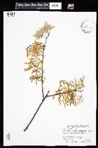 Quercus ellipsoidalis E.J. Hill 453912[1004795]Smith, Welby 291432001-05-08 United States, Minnesota, Freeborn, Freeborn County ... Helmer Myhre State Park, about 4 miles southeast of Albert Lea (town) ... T102N R20W NW1/4 of NW1/4 of Sec 19. 102N 20W 19, 43.6258333 -93.2861111 |
MIN:Plants | 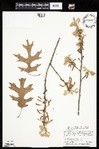 Quercus ellipsoidalis E.J. Hill 509706[1004958]Smith, Welby 283882000-05-02 United States, Minnesota, Chisago, Carlos Avery Wildlife Management Area. Chisago County ... Carlos Avery State Wildlife Management Area, about 3 miles N-NE of Stacy ... T 34N R 21W NE1/4 of NE1/4 of Sec 26. 034N 21W 26, 45.4097222 -92.9161111 |
MIN:Plants | 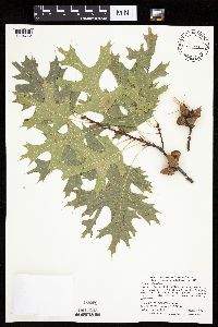 Quercus ellipsoidalis E.J. Hill 477157[1004772]Smith, Welby 290152000-08-20 United States, Minnesota, Ramsey, Ramsey County ... Snail Lake Regional Park, in Shoreview ...T 30N R23W SW1/4 of SE1/4 of Sec 24;Snail Lake Vadnais Lake County Park;030N;23W;24, 45.0633333 -93.1161111 |
MIN:Plants | 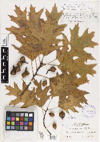 Quercus ellipsoidalis var. kaposianensis John W. Moore 375541[1002117]Moore, John 152161941-10-10 United States, Minnesota, Dakota, Kaposia Park, South St. Paul;;;;, 44.9083 -93.061474 |
MIN:Plants |  Quercus alba L. 509647[1004723]Smith, Welby 291172000-09-18 United States, Minnesota, Anoka, Anoka County ... Pioneer Path Park, in the city of Blaine ... T 31N R 23W SE1/4 of SE1/4 of Sec 4;;031N;23W;04, 45.1991667 -93.2075 |
MIN:Plants |  473135[1004797]Nation, R. 94-2611994-07-18 United States, Minnesota, Mower, Lake Louise State Park. Mower Co.; Tract #1B. T101N R14W W1/2 SE1/4 of Sec. 21;Lake Louise State Park;101N;14W;21, 43.53658 -92.51904 |
MIN:Plants |  Quercus macrocarpa Michaux 479229[1005257]Anderson, Chel 99251999-07-03 United States, Minnesota, Cook, Cook Co.; North Shore Highlands; T62N R2E SE 1/4 of SE 1/4 of SW 1/4 of Sec. 33;North Shore / Superior National Forest;062N;02E;33, 47.80933 -90.20067 |
MIN:Plants |  Quercus velutina Lamarck 429030[1005430]Smith, Welby 290052000-08-18 United States, Minnesota, Wabasha, Dorer Memorial Hardwood State Forest. Wabasha County ... Kruger State Recreation Area. In the Zumbro River Valley about 4 miles N-NW of Kellogg ... T 110N R 11W SE1/4 of SE1/4 of Sec 12. 110N 11W 12, 44.3397217 -92.0763855 |
MIN:Plants |  Quercus macrocarpa Michaux 509004[1005123]Smith, Welby 264191996-09-11 United States, Minnesota, Wadena, Wadena County ... About 5 miles southeast of Nimrod, on the north side of County Road 139 ... T 136N R 33W SW1/4 of sE1/4 of sec 1. 136N 33W 1, 46.6188889 -94.788887 |
MIN:Plants |  Quercus macrocarpa Michaux 896908[1005096]Haferman, J. 2941996-08-25 United States, Minnesota, Scott, Approximately 0.1 miles north-northeast of intersection of State Highway 13 and County Road 44, north side of highway. SW of SW of section;;115N;22W;36, 44.7245862 -93.4090306 |
MIN:Plants |  Quercus macrocarpa Michaux 909997[1005205]Smith, Welby 244991994-06-27 United States, Minnesota, Hubbard, Crow Wing Chain Wildlife Management Area. Hubbard County ... Crow Wing Chain State Wildlife Management Area; about 11 miles southeast of Park Rapids ... T139N R33W NE1/4 of SE1/4 of Sec 15. 139N 33W 15, 46.8536111 -94.8366667 |
MIN:Plants |  Quercus macrocarpa Michaux 462002[1005107]Smith, Welby 289762000-08-14 United States, Minnesota, Ramsey, Ramsey County ... Battle Creek County Park, in St. Paul ... T28N R22W SE1/4 of SE1/4 of Sec 3;Battle Creek County Park;028N;22W;03, 44.9361115 -93.0280533 |
MIN:Plants |  438156[1005282]Smith, Welby 273241998-07-09 United States, Minnesota, Becker, Becker County...Smokey Hills State Forest, about 4 miles W-SW of Osage...T 140N R 37W SE1/4 of NW1/4 of Sec 35;Smokey Hills State Forest;140N;37W;35, 46.8994444 -95.3202778 |
MIN:Plants |  Quercus macrocarpa Michaux 428972[1005099]Smith, Welby 280401999-07-21 United States, Minnesota, Lac Qui Parle, Lac Qui Parle County ... along the Lac Qui Parle River, about 3 air miles from its confluence with the Minnesota River ... T 118N R 42W SW1/4 of SW1/4 of sec 27. 118N 42W 27, 44.9944458 -95.922226 |
MIN:Plants |  487860[1005310]Lee, Michael MDL29402001-06-14 United States, Minnesota, Lake, Superior National Forest. Lake County ... North of the mining tunnel, two miles northeast of Cramer ... above the Caribou River valley southeast of Paccini Lake ... T59N R6W NE1/4 of SW1/4 and SW1/4 of SW1/4 Sec. 35; T58N R6W NE1/4 of NE1/4 Sec.3. 059N 06W 35, 47.55143 -91.05461 |
Google Map
Google Maps is a web mapping service provided by Google that features a map that users can pan (by dragging the mouse) and zoom (by using the mouse wheel). Collection points are displayed as colored markers that when clicked on, displays the full information for that collection. When multiple species are queried (separated by semi-colons), different colored markers denote each individual species.