University of Minnesota
http://www.umn.edu/
612-625-5000
http://www.umn.edu/
612-625-5000
Minnesota Biodiversity Atlas
Bell Museum
Dataset: MIN-Plants
Taxa: Astragalus
Search Criteria: excluding cultivated/captive occurrences
Bell Museum plants | |
 MIN:Plants | 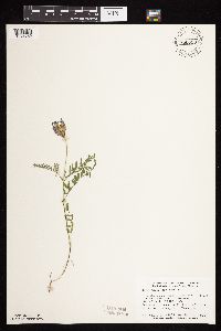 Astragalus agrestis Douglas ex G. Don 758033[1074762]Smith, Welby 65531982-07-01 United States, Minnesota, Yellow Medicine, Sioux Nation State Wildlife Management Area, ca 8 mi WSW of Canby, NW1/4 SW1/4 S17, T114N, R46W;Sioux Nationalion Wildlife Management Area;114N;46W;17, 44.681835 -96.4295916 |
MIN:Plants | 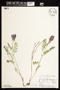 Astragalus agrestis Douglas ex G. Don 758223[1074827]Smith, Welby 62651982-06-10 United States, Minnesota, Becker, Ogema Springs Wildlife Management Area / White Earth Indian Reservation. Becker Co. Ogema Springs Wildlife Management Area, on the E side of US Hwy 59, ca 2 1/2 S of Ogema, SW1/4 NE1/4 S6, T141 Becker Co. Ogema Springs Wildlife Management Area, on the E side of US Hwy 59, ca 2 1/2 S of Ogema, SW1/4 NE1/4 S6, T141N, R41W. 141N 41W 6, 47.0570941 -95.9229944 |
MIN:Plants | 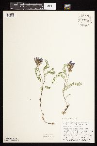 Astragalus agrestis Douglas ex G. Don 758427[1074820]Smith, Welby 60981982-05-30 United States, Minnesota, Renville, Renville Co.; right-of-way of the CMSP & P RR line, ca 300 ft W of Co Rd 61 and 2 mi W of Renville (town), SE1/4 SE1/4 S Renville Co.; right-of-way of the CMSP & P RR line, ca 300 ft W of Co Rd 61 and 2 mi W of Renville (town), SE1/4 SE1/4 S2, T115N, R37W. 115N 37W 2, 44.7961673 -95.2695407 |
MIN:Plants | 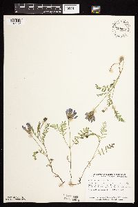 Astragalus agrestis Douglas ex G. Don 758447[1074763]Smith, Welby 60561982-05-26 United States, Minnesota, Murray, ca 7 1/2 mi SW of Slayton, NE1/4 SW1/4 S3, T105N, R42W;;105N;42W;3, 43.9281143 -95.8736696 |
MIN:Plants | 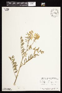 758462[1074961]Smith, Welby 6802A1982-07-19 United States, Minnesota, Marshall, About 2 mi SSW of Holt. NW1/4 SW1/4 of section;;155N;43W;08, 48.2615553 -96.2061538 |
MIN:Plants | 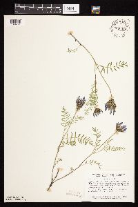 Astragalus agrestis Douglas ex G. Don 758506[1074761]Smith, Welby 60791982-05-29 United States, Minnesota, Kandiyohi, Kandiyohi Co.; About 3 1/2 mi NE of Raymond, between Burlington Northern RR tracks and State Hwy 23, about 40 ft about 40 ft NE of its junction with CO Hwy 1; SW1/4 NW1/4 S10, T118N, R36W. 118N 36W 10, 45.0440944 -95.1760679 |
MIN:Plants | 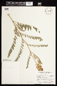 758633[1074951]Smith, Welby 68871982-07-28 United States, Minnesota, Mower, Prairie strip adjacent to the E side of US Trunk Hwy 63, about 2 mi N of Racine. NE1/4 NE1/4 of section;Racine Prairie Scientific Natural Area;104N;14W;22, 43.7976425 -92.4992666 |
MIN:Plants | 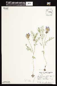 Astragalus agrestis Douglas ex G. Don 758834[1074746]Smith, Welby 61051982-05-30 United States, Minnesota, Meeker, Meeker Co.; About 3 mi ESE of Litchfield, right-of-way of the Burlington Northern RR, NE1/4 SW1/4 Sec. 17, T119N, R30W. 119N 30W 17, 45.1163224 -94.4720918 |
MIN:Plants | 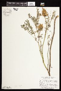 758910[1074960]Smith, Welby 75131982-08-24 United States, Minnesota, Jackson, On the N side of Co Hwy 4, about 1/2 mi E of its junction with State Hwy 86. NE1/4 SW1/4 ;Sangl Wildlife Management Area;101N;36W;21, 43.5373326 -95.1644274 |
MIN:Plants | 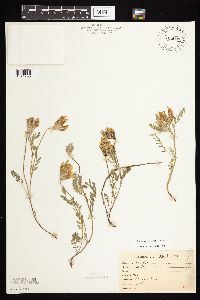 Astragalus agrestis Douglas ex G. Don 765005[1074780]Lugger, O. 63771900-06-08 United States, Minnesota, Nobles, Worthington;;102N;40W;00, 43.630153 -95.594338 |
MIN:Plants | 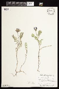 Astragalus agrestis Douglas ex G. Don 770347[1074798]Smith, Welby 80371983-06-07 United States, Minnesota, Becker, Becker Co. Becker Waterfowl Production Area, ca 6 mi NNW of Lake Park, SW1/4 NW1/4 S17, T140N, R43W;;140N;43W;17, 46.9423039 -96.1430873 |
MIN:Plants | 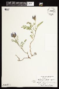 Astragalus agrestis Douglas ex G. Don 770481[1074799]Smith, Welby 77701983-06-01 United States, Minnesota, Swift, Swift Co.; between US Hwy 12 and the Burlington Northern RR tracks, ca 2.5 mi NW of DeGraff, SW1/4 NE1/4 S24, T121N, R39 Swift Co.; between US Hwy 12 and the Burlington Northern RR tracks, ca 2.5 mi NW of DeGraff, SW1/4 NE1/4 S24, T121N, R39W. 121N 39W 24, 45.2746411 -95.5106413 |
MIN:Plants | 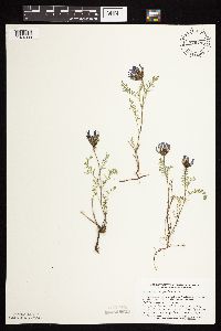 Astragalus agrestis Douglas ex G. Don 770495[1074800]Smith, Welby 77571983-06-01 United States, Minnesota, Swift, Swift Co.; between State Hwy 9 and the Burlington Northern RR tracks, ca 2.5 mi NW of Clontarf; NW1/4 SW1/4 S4, T122N, R Swift Co.; between State Hwy 9 and the Burlington Northern RR tracks, ca 2.5 mi NW of Clontarf; NW1/4 SW1/4 S4, T122N, R40W. 122N 40W 4, 45.4052 -95.6959837 |
MIN:Plants | 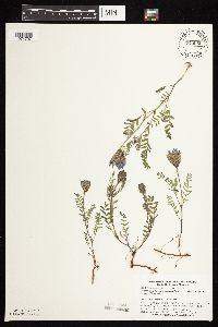 Astragalus agrestis Douglas ex G. Don 770565[1074797]Smith, Welby 80651983-06-08 United States, Minnesota, Polk, Polk County...Belgium State Wildlife Management Area, ca 4 mi ENE of Euclid, NW1/4 NE1/4 S16, T152N, R46W;Belgium Wildlife Management Area;152N;46W;16, 47.9851447 -96.5582728 |
MIN:Plants | 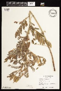 778059[1074930]Duxbury, Alexis 17001983-07-19 United States, Minnesota, Jackson, part of SW1/4 SE1/4 of section;Blue Gentian Prairie;103N;36W;13, 43.7249294 -95.1050766 |
MIN:Plants | 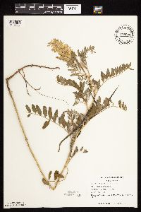 778080[1074928]Duxbury, Alexis 16211983-07-19 United States, Minnesota, Nobles, Part of SE1/4 SW1/4 of section;Compass Prairie Scientific Natural Area;101N;41W;03, 43.5801077 -95.7438528 |
MIN:Plants | 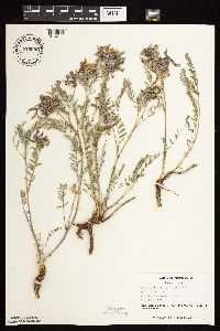 778086[1074929]Duxbury, Alexis 10271983-05-25 United States, Minnesota, Jackson, part of SW1/4 SE1/4 of section;Blue Gentian Prairie;103N;36W;13, 43.7249294 -95.1050766 |
MIN:Plants | 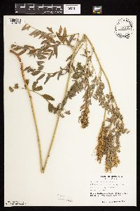 778105[1074931]Duxbury, Alexis 19101983-08-01 United States, Minnesota, Lincoln, portions of S1/2 S19, and SW1/4 S20;Hole-in-the-Mountain Prairie, The Nature Conservancy;109N;45W;, 44.233753 -96.3121788 |
MIN:Plants | 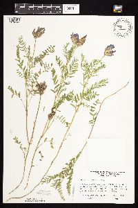 Astragalus agrestis Douglas ex G. Don 780455[1074744]Ownbey, Gerald 69461984-07-11 United States, Minnesota, Mahnomen, Mahnomen Co. T145N, R40W, S35, SW1/4, N side of Minn. Rt. 200, 7.9 mi W of its jnc with Clearwtaer Co Rt. 7 in Roy Lake;White Earth Indian Reservation;145N;40W;35, 47.3314314 -95.7104867 |
MIN:Plants | 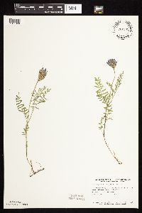 Astragalus agrestis Douglas ex G. Don 781332[1074833]Smith, Welby 89291984-05-30 United States, Minnesota, Lac Qui Parle, Hegland Wildlife Management Area. Lac Qui Parle Co.; In the Minnesota Valley, ca 5 mi E of Louisburg, in a National Waterfowl Production Area, NE1/4 SW1/4 S4, T119N, R43W. 119N 43W 4, 45.145671 -96.0523319 |
MIN:Plants | 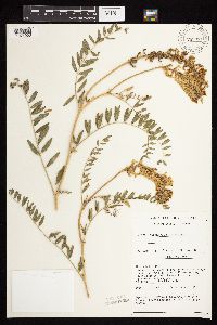 782371[1074953]Tenney, M. 4911982-07-29 United States, Minnesota, Fillmore, E1/2 SW1/4 NW1/4 NE1/4 of section;Forestville State Park;102N;12W;13, 43.6377242 -92.2192693 |
MIN:Plants | 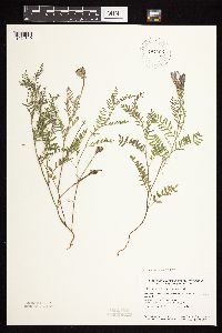 Astragalus agrestis Douglas ex G. Don 787665[1074819]Smith, Welby 105101985-06-27 United States, Minnesota, Clay, Clay County ... Barnesville State Wildlife Management Area, about 6 mi NE of Barnesville ... SE1/4 SE1/4 Sec1 T137N R45W;Barnesville Wildlife Management Area;137N;45W;1, 46.705463 -96.303411 |
MIN:Plants | 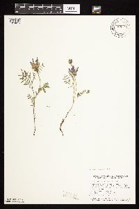 Astragalus agrestis Douglas ex G. Don 789727[1074821]Smith, Welby 102901985-05-30 United States, Minnesota, Cottonwood, Expandere Wildlife Management Area. Cottonwood County ... Expandere State Wildlife Management Area, about 13 mi W-NW of Windom ... SE1/4 SW1/4 Sec 1, T105N, R38W. 105N 38W 1, 43.9225006 -95.351944 |
MIN:Plants | 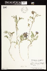 Astragalus agrestis Douglas ex G. Don 792192[1074831]Smith, Welby 102411985-05-29 United States, Minnesota, Lyon, Prairie Marshes State Wildlife Management Area, ca 4 mi NNW of Russell, SE1/4 SW1/4 S36, T11N, R43W;Prairie Marshes Wildlife Management Area;111N;43W;36, 44.3781193 -95.9681021 |
MIN:Plants | 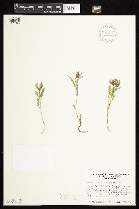 Astragalus agrestis Douglas ex G. Don 795473[1074825]Cholewa, A. 13401987-05-15 United States, Minnesota, Wilkin, Rothsay-Gronseth Prairie "set aside" unit on Hwy 169, 0.3 mi S of Hwy 26; T135N, R45W, S32 NW1/4.;;135N;45W;32, 46.4639383 -96.3752945 |
MIN:Plants | 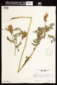 795539[1074938]Cholewa, A. 14481987-07-22 United States, Minnesota, Clay, Wildlife Management Area at jnc of hwys 26 & 113; adjacent to Hotsie Lake; beneath power lines. SE corner of section;<No data>;140N;45W;32, 46.898063 -95.7628681 |
MIN:Plants | 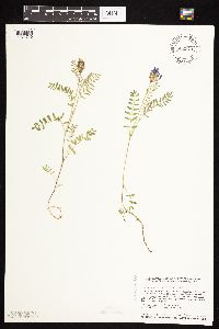 Astragalus agrestis Douglas ex G. Don 802924[1074749]Smith, Welby 117111986-06-12 United States, Minnesota, Pipestone, Prairie Coteau Scientific Natural Area. Prairie Coteau State Scientific and Natural Area (Aetna Prairie); on the NW side of State Hwy 23, ca 2 1/2 mi NE of Holland. NW1/4 SE1/4 S32, T108N, R44W. 108N 44W 32, 44.1152763 -96.1522217 |
MIN:Plants | 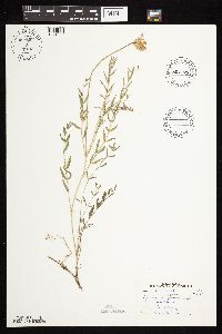 Astragalus agrestis Douglas ex G. Don 804775[1074832]Gerbig, R. s.n.1972-06-23 United States, Minnesota, Pope, Strandness Prairie;Strandness Prairie, The Nature Conservancy;125N;38W;6, 45.6651515 -95.5001117 |
MIN:Plants | 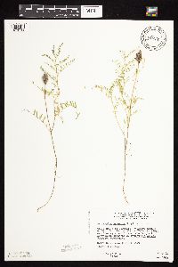 Astragalus agrestis Douglas ex G. Don 815938[1074743]Wheeler, Gerald 112421988-07-21 United States, Minnesota, Big Stone, Krogsrud Wildlife Management Area. Big Stone Co.; Ca 6 mi N of Correll; waterfowl area N of Rte 64; SW1/4 SW1/4 S2, T121N, R44W (Akron Twp), overlooking a small lake (W side). 121N 44W 2, 45.3193641 -96.1480904 |
MIN:Plants | 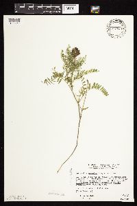 Astragalus agrestis Douglas ex G. Don 815940[1074750]Ownbey, Gerald 112281988-07-19 United States, Minnesota, Traverse, Geyer Wildlife Management Area. Traverse Co.; ca 17 mi E of Browns Valley; waterfowl area N of Rte 2, overlooking small lake (E side), S1/2 SE1/4 S32, T125N, R46W (Tara Twp). 125N 46W 32, 45.5926254 -96.479571 |
MIN:Plants | 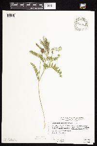 Astragalus agrestis Douglas ex G. Don 815943[1074742]Wheeler, Gerald 115301988-07-27 United States, Minnesota, Lac Qui Parle, Lac Qui Parle Co.; ca 10.5 mi E of Bellingham; waterfowl area N of Rte 207; SW1/4 S5, T119N, R43W (Hantho Twp);Hastad Wildlife Management Area;119N;43W;5, 45.145667 -96.0730757 |
MIN:Plants | 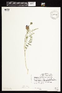 Astragalus agrestis Douglas ex G. Don 816341[1074751]Wheeler, Gerald 106461988-06-05 United States, Minnesota, Norman, Norman County...Ca 3.2 mi W of Syre; S of Rte 39...S1/2 NE1/4 NE1/4 S25, T143N, R45W (Rockwell Twp);Twin Valley Wildlife Management Area;143N;45W;25, 47.1730267 -96.3328246 |
MIN:Plants | 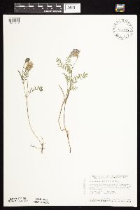 Astragalus agrestis Douglas ex G. Don 841016[1074748]Smith, Welby 127151987-05-20 United States, Minnesota, Pipestone, Altona Wildlife Management Area. Pipestone County ... Altona State Wildlife Management Area, about 1.5 mi southeast of Verdi ... NW1/4 NW1/4 sec.1 T108N R46W. 108N 46W 1, 44.1966667 -96.3249969 |
MIN:Plants | 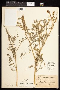 133978[1075046]Ballard, C. B4881891-07-00 United States, Minnesota, Scott, Prior Lake;;N;;, 44.724031 -93.43234 |
MIN:Plants | 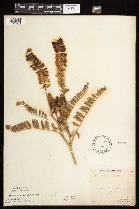 134471[1074978]Manning, Sara s.n.1883-07-13 United States, Minnesota, Wabasha, Lake City;;N;;, 44.449412 -92.266844 |
MIN:Plants | 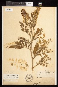 134472[1075000]Leonard, W. s.n1886-00-00 United States, Minnesota, Chippewa, Montevideo;;117N;40W;, 44.953148 -95.715397 |
MIN:Plants | 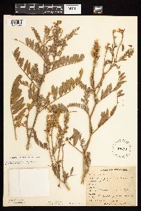 134473[1074895]Rosendahl, C. 23501909-08-11 United States, Minnesota, Ft. Snelling Reservation [old regional park spanning junction of Minnesota and Mississippi rivers];;028N;23W;, 44.891664 -93.18101 |
MIN:Plants | 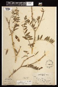 134475[1074974]Skinner, S. 2441902-06-28 United States, Minnesota, Jackson, Lake Shetek. Heron Lake Region.;;N;;, 43.794404 -95.322499 |
MIN:Plants | 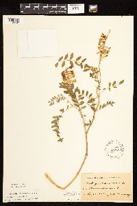 134476[1122592]Pomeroy, J. s.n.1880-08-00 United States, Minnesota, Hennepin, [no further data];;;;, 45 -93.47 |
MIN:Plants | 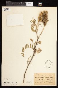 134477[1075044]Sheldon, Edmund S34151892-08-00 United States, Minnesota, Otter Tail, Eagle Lake;;N;;, 46.1728347 -95.6976807 |
MIN:Plants | 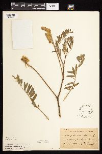 134478[1075045]Frost, W. F2331892-07-00 United States, Minnesota, Kandiyohi, Willmar;;119N;35W;, 45.12194 -95.04306 |
MIN:Plants | 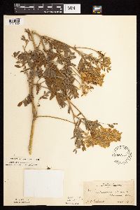 134479[1074856]Ballard, C. 29491908-08-05 United States, Minnesota, Clay, Moorhead;;N;;, 46.869627 -96.747325 |
MIN:Plants | 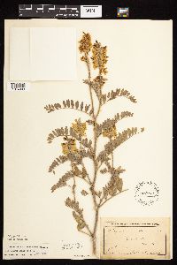 134480[1074903]Ballard, A. AB271893-07-00 United States, Minnesota, Goodhue, Zumbrota;;N;;, 44.2894248 -92.6611953 |
MIN:Plants | 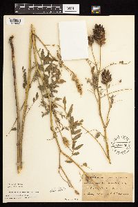 134482[1074902]Sheldon, Edmund S35981892-08-00 United States, Minnesota, Otter tail, Battle Lake;; T133N R40W S00, 46.280278 -95.713056 |
MIN:Plants | 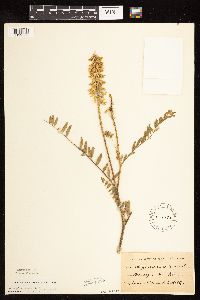 134483[1122588]Holtz, T. s.n.1891-06-00 United States, Minnesota, Hennepin, [no further data];;;;, 45 -93.47 |
MIN:Plants | 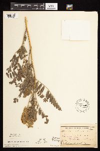 134484[1075016]Sheldon, Edmund S32751892-07-00 United States, Minnesota, Mille Lacs, Bridgeman [other collections by Sheldon indicated Mille Lacs Co.; original name for current town of Foreston];;037N;27W;33, 45.6560302 -93.7079902 |
MIN:Plants | 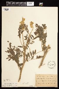 134485[1075036]Ballard, C. B10821892-07-00 United States, Minnesota, Nicollet, Courtland;;109N;29W;, 44.2559381 -94.3475946 |
MIN:Plants | 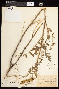 134486[1075037]Taylor, B. T7151891-07-00 United States, Minnesota, Faribault, Minnesota Lake;;N;;, 43.8406168 -93.7180717 |
MIN:Plants | 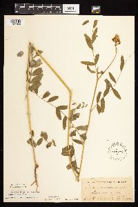 134490[1074855]Taylor, B. T9121891-07-00 United States, Minnesota, Pope, Glenwood;;N;;, 45.652639 -95.382892 |
MIN:Plants | 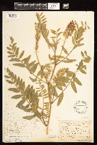 134493[1122593]Sandberg, John s.n.1890-07-00 United States, Minnesota, Hennepin, [no further data];;;;, 45 -93.47 |
MIN:Plants | 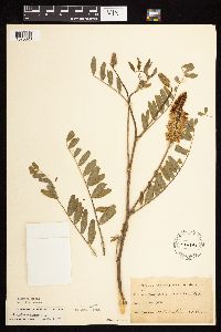 134495[1075028]Herrick, C. s.n.1878-06-00 United States, Minnesota, Hennepin, Minneapolis;;N;;, 44.970736 -93.268643 |
MIN:Plants | 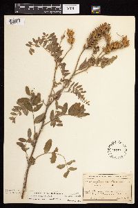 134497[1075038]MacMillan, C.; et al. 661900-08-00 United States, Minnesota, Polk, Crookston;;150N;46W;30, 47.782 -96.60007 |
MIN:Plants |  134499[1122594]Holzinger, John s.n.1886-07-00 United States, Minnesota, Winona, [no further data];;N;;, 43.978945 -91.713211 |
MIN:Plants |  134500[1122591]Holzinger, John s.n.1886-07-00 United States, Minnesota, Winona, Winona Co.;;N;;, 43.978945 -91.713211 |
MIN:Plants |  134501[1122590]Aiton, G. s.n.1889-08-00 United States, Minnesota, Hennepin, [no further data];;;;, 45 -93.47 |
MIN:Plants |  134502[1074962]Lyon, H. 2571899-07-20 United States, Minnesota, Houston, Jefferson;Dorer Memorial Hardwood State Forest;101N;04W;35, 43.50806 -91.28287 |
MIN:Plants |  134503[1122595]Burglehaus, F. s.n.1891-06-00 United States, Minnesota, Hennepin, [no further data];;;;, 45 -93.47 |
MIN:Plants |  226413[1075015]Sheldon, Edmund s.n.1893-07-30 United States, Minnesota, Mille Lacs, Bridgeman [other collections by Sheldon indicated Mille Lacs Co.; original name for current town of Foreston];;037N;27W;33, 45.6560302 -93.7079902 |
MIN:Plants |  265546[1075023]Stevenson, J. 1781912-07-16 United States, Minnesota, Beltrami, Bemidji;;N;;, 47.479828 -94.863111 |
MIN:Plants |  267101[1074979]Anonymous 771912-07-00 United States, Minnesota, Kandiyohi, Willmar;;119N;35W;, 45.12194 -95.04306 |
MIN:Plants |  267174[1074881]Anonymous 771912-07-00 United States, Minnesota, Kandiyohi, Willmar;;119N;35W;, 45.12194 -95.04306 |
MIN:Plants |  276069[1074898]Grant, Martin 28661929-07-21 United States, Minnesota, Hubbard, Itasca Park. La Salle Springs.;Itasca State Park;143N;35W;7, 47.2178446 -95.1612028 |
MIN:Plants |  276070[1074899]Grant, Martin 30801929-08-13 United States, Minnesota, Clearwater, Itasca Park. Morrison Lake. SW1/4 SW1/4 Sec. 34, T143N, R36W.;Itasca State Park;143N;36W;34, 47.154347 -95.230638 |
MIN:Plants |  278133[1074969]Roberts, Thomas s.n.1877-08-00 United States, Minnesota, Hennepin, Minneapolis;;N;;, 44.970736 -93.268643 |
MIN:Plants | 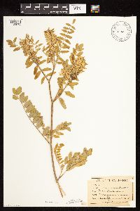 281660[1122589]Sandberg, John 1541890-06-00 United States, Minnesota, Hennepin, [no further data];;;;, 45 -93.47 |
MIN:Plants | 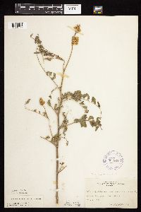 306963[1074999]Cottrell, R. s.n.1935-07-18 United States, Minnesota, Anoka, Fridley;;030N;24W;, 45.079531 -93.266372 |
MIN:Plants | 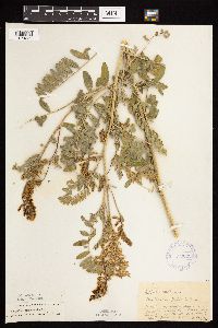 332333[1074880]Roberts, Thomas s.n.1925-07-30 United States, Minnesota, Saint Louis, Burntside Lake.;Superior National Forest;063N;13W;00, 47.93205 -91.98786 |
MIN:Plants | 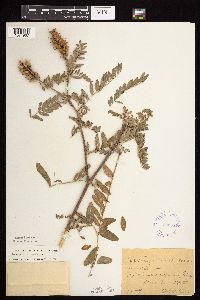 333551[1074967]Oestlund, O. 132-41888-08-10 United States, Minnesota, Hennepin, Minneapolis;;N;;, 44.970736 -93.268643 |
MIN:Plants | 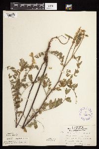 347265[1074980]Lakela, Olga 20671937-07-24 United States, Minnesota, Saint Louis, Near the Sec. line. 19 & 20, Duluth.;;N;;, 46.771047 -92.123058 |
MIN:Plants | 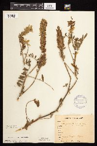 357247[1074998]Stevenson, J. 3211912-08-15 United States, Minnesota, Itasca, Grand Rapids;;055N;25W;, 47.225976 -93.523348 |
MIN:Plants | 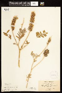 365212[1122598]Holzinger, John s.n.1901-08-01 United States, Minnesota, Winona, Winona Co.;;N;;, 43.978945 -91.713211 |
MIN:Plants | 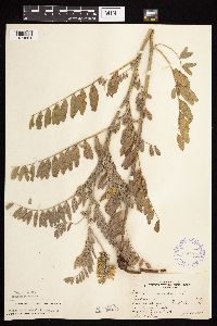 366408[1074861]Butters, F.; et al. 72491939-07-20 United States, Minnesota, Faribault, Near Iowa - Minn. State Line, S of Blue Earth.;;;;, 43.513092 -94.100809 |
MIN:Plants | 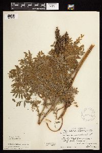 367482[1074968]Moore, John; et al. 104771938-09-13 United States, Minnesota, Traverse, Mud Lake, upper end of Lake Traverse. Traverse Co.;;;;, 45.804025 -96.587684 |
MIN:Plants | 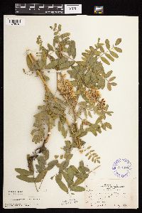 371493[1075042]Moore, John; et al. 147761941-07-07 United States, Minnesota, Becker, Becker County...SE shore of Cotton Lake, Erie Twp.;;139N;40W;12, 46.8684858 -95.6779656 |
MIN:Plants | 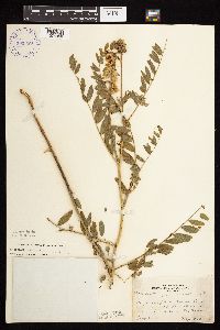 393389[1074966]Lakela, Olga 69921947-07-29 United States, Minnesota, Saint Louis, Moose Line Road, near the St. Louis River, White Twp.;;N;;, 47.473351 -92.123349 |
MIN:Plants | 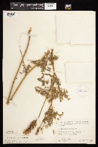 412240[1074944]Moore, John; et al. 117811939-08-15 United States, Minnesota, Koochiching, Koochiching County...2 mi. east of Tilson Bay, Rainy Lake;;071N;22W;, 48.597559 -93.196581 |
MIN:Plants | 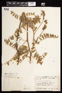 412853[1074939]Moore, John; et al. 116271939-08-10 United States, Minnesota, Kittson, N section line of Sec. 15, Poppeeton Twp, 3.9 mi. E of Lancaster. Kittson Co.;;;;, 48.858283 -96.718432 |
MIN:Plants | 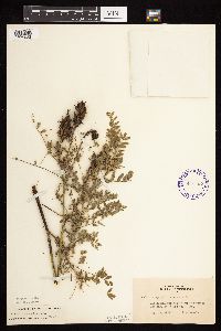 416733[1075022]Lakela, Olga 94811949-08-27 United States, Minnesota, Saint Louis, Kabetogama Springs on road to Gappas Landing;Voyageurs National Park;N;;, 48.426761 -93.027374 |
MIN:Plants | 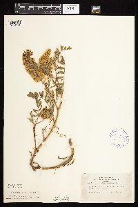 420036[1075001]Lakela, Olga 110991950-08-04 United States, Minnesota, Saint Louis, White Face River dam, along the trail.;;N;;, 47.04127 -92.73627 |
MIN:Plants | 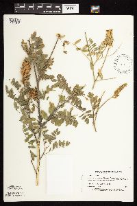 439477[1074917]Myhre, K. 30681992-08-14 United States, Minnesota, Cass, Cass Co. Located 1 mi NW of Lake Ada; T139N R29W NE1/4 of NW1/4 of Sec 21;;139N;29W;21, 46.8418763 -94.352798 |
MIN:Plants | 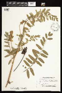 439752[1074916]Myhre, K. 39751993-06-28 United States, Minnesota, Pine, Pine Co. Located on the island in Pokegema Lake; T39N R22W NE1/4 of SW1/4 of Sec 24;;039N;22W;24, 45.8535626 -93.0315117 |
MIN:Plants | 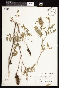 440043[1074920]Myhre, K. 32421992-09-01 United States, Minnesota, Cass, Cass Co. Located 1/4 mi N of Ten Mile Lake; Portage Lake; T141N R31W SE1/4 of NE1/4 of Sec 26;Chippewa National Forest;141N;31W;26, 47.002988 -94.567126 |
MIN:Plants | 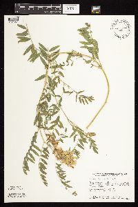 440499[1075031]Smith, Welby 148851988-08-17 United States, Minnesota, Meeker, Meeker Co.; At the SW end of Round Lake, about 3 mi S-SE of Litchfield; at the public access; NW1/4 NE1/4 sec. 36, T119N R31W. 119N 31W 36, 45.0777779 -94.5105591 |
MIN:Plants | 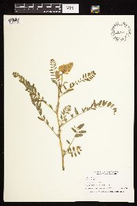 441828[1075033]Nation, R.; Bolin, Kathy 94-2191994-07-05 United States, Minnesota, Mower, Lake Louise State Park. Mower Co.; Tract 6. T101N R14W SW1/4 of NE1/4 of sec. 29;Lake Louise State Park;101N;14W;29, 43.5220732 -92.5388826 |
MIN:Plants | 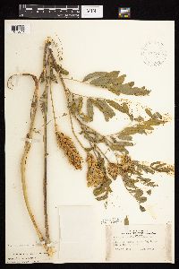 442561[1075047]Lakela, Olga 134211951-07-19 United States, Minnesota, Saint Louis, Shore of Namakan Lake at Big Island;Voyageurs National Park;N;;, 48.422582 -92.600589 |
MIN:Plants | 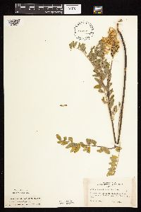 443189[1075025]Lakela, Olga 130811915-07-11 United States, Minnesota, Saint Louis, On Namakan Lake, 4 mi. from Kettle Falls.;Voyageurs National Park;N;;, 48.504446 -92.636764 |
MIN:Plants | 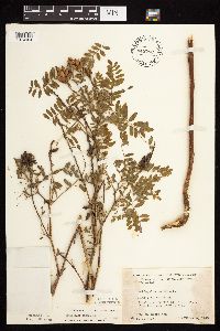 445783[1074964]Moore, John; Huff, N. 183161945-10-04 United States, Minnesota, Pine, Along the St. Croix River, 11 mi. E of Pine City;;N;;, 45.827753 -92.777059 |
MIN:Plants | 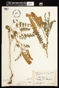 446757[1074981]Moore, John; Huff, N. 178331945-07-24 United States, Minnesota, Morrison, Along the r.r. 1 1/2 mi. NW of Little Falls;;N;;, 46.009079 -94.397685 |
MIN:Plants | 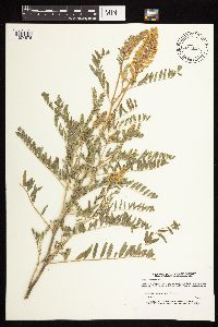 447606[1074876]Lee, Michael MDL2651993-07-20 United States, Minnesota, Dakota, Dakota Co.; 3 miles NW of Stanton; T 112N R 19W SW1/4 of SW1/4 of Sec 24;;112N;19W;24, 44.4936608 -93.0493718 |
MIN:Plants | 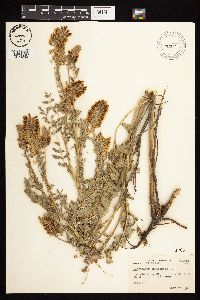 459631[1074892]Abbott, Robinson s.n.1968-07-17 United States, Minnesota, Wilkin, Wilkin Co.; along Gt. Northern RR track about 1 mi. S. of Doran.;;131N;46W;, 46.171966 -96.471841 |
MIN:Plants | 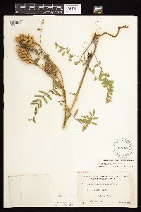 462996[1074906]Lakela, Olga 148791952-07-13 United States, Minnesota, Saint Louis, Shore of Pine Island, Kabetogama Lake;Voyageurs National Park;N;;, 48.448524 -92.930707 |
MIN:Plants | 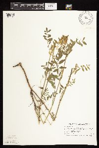 473791[1075017]Smith, Welby 207761992-07-13 United States, Minnesota, Wadena, Wadena County ... Between Trunk Highway 10 and the Burlington Northern railroad tracks, about 3 miles southeast of Wadena ... T 134N R 35W SE1/4 of SW1/4 of Sec 14.. 134N 35W 14, 46.4158325 -95.0627747 |
MIN:Plants | 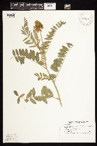 473795[1074912]Smith, Welby 208731992-07-15 United States, Minnesota, Marshall, Marshall County ... In Old Mill State Park, about 11 miles east of Argyle ... T 156N R 46W NW1/4 of SE1/4 of Sec 4.;Old Mill State Park;156N;46W;4, 48.3602791 -96.5702744 |
MIN:Plants | 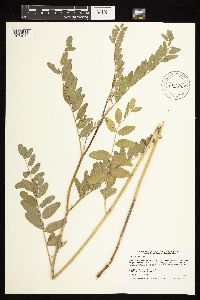 475745[1074972]Smith, Welby 205551992-06-24 United States, Minnesota, Brown, Boesch Wildlife Management Area. Brown County ... Boesch State Wildlife Management Aea, about 3 miles northwest of New Ulm in the Minnesota River Valley ... T 110N R 31W SW1/4 of NW1/4 of Sec 3. 110N 31W 3, 44.3624992 -94.5494461 |
MIN:Plants | 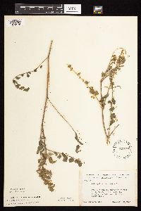 499902[1074975]Ball, E. 181946-07-22 United States, Minnesota, Marshall, Mud Lake Nat'l Wildlife Refuge. R41W, T156N, Sec. 14.;Agassiz National Wildlife Refuge;156N;41W;14, 48.3311945 -95.8845366 |
MIN:Plants | 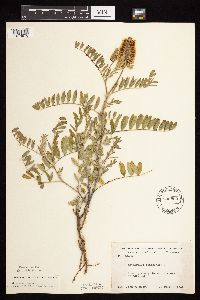 500805[1074976]Moore, John 204191949-07-06 United States, Minnesota, Otter Tail, Along the north shore of Wall Lake;;N;;, 46.290793 -95.964777 |
MIN:Plants |  501646[1074945]Stevens, O. s.n.1954-09-14 United States, Minnesota, Pipestone, Pipestone National Monument;Pipestone National Monument;106N;46W;, 44.013519 -96.325442 |
MIN:Plants |  508697[1075032]Smith, Welby 143991988-07-01 United States, Minnesota, Nobles, Nobles County ... About 2 mi SW of Worthington ... on the right-of-way of the C&NW Railroad ... SW1/4 SE1/4 sec.32 T102N R40W. 102N 40W 32, 43.5877762 -95.6616669 |
MIN:Plants |  515987[1074940]Smith, Welby 210331992-07-20 United States, Minnesota, Redwood, Redwood County ... in the Minnesota River Valley, about 3 mi NE of Belview ... T114N R37W NE1/4 of NW1/4 of Sec 27;;114N;37W;27, 44.6563873 -95.2977753 |
MIN:Plants |  516140[1074986]Butts, A. 351996-08-07 United States, Minnesota, Lyon, Camden State Park; Lyon Co. - Lyons Township. NW 1/4 of SE 1/4, sect. 7, T110N R42W;Camden State Park;110N;42W;7, 44.3487268 -95.9476934 |
Google Map
Google Maps is a web mapping service provided by Google that features a map that users can pan (by dragging the mouse) and zoom (by using the mouse wheel). Collection points are displayed as colored markers that when clicked on, displays the full information for that collection. When multiple species are queried (separated by semi-colons), different colored markers denote each individual species.