University of Minnesota
http://www.umn.edu/
612-625-5000
http://www.umn.edu/
612-625-5000
Minnesota Biodiversity Atlas
Bell Museum
Dataset: MIN-Plants
Taxa: Carex
Search Criteria: excluding cultivated/captive occurrences
Bell Museum plants | |
 MIN:Plants |  Carex siccata Dewey 477843[1016273]Wheeler, Gerald 168361997-07-25 United States, Minnesota, Benton, Benton County ... Ca. 0.7 mi. SSW of Watab on Rte. 55 ... W1/2 NW1/4 SE1/4 Sec. 27 T37N R31W (Watab 27);;037N;31W;27, 45.668416 -94.184846 |
MIN:Plants |  483920[1113692]Anderson, Craig 12862001-06-21 United States, Minnesota, Pope, Pope Co.; T123N R36W: 1/4 of NE1/4 of SW1/4 of Sect. 30 [sic];Ordway Prairie, The Nature Conservancy;123N;36W;30, 45.434262 -95.245018 |
MIN:Plants | Carex sterilis Willdenow 476802[1118169]Whitfeld, T.J.S. United States, Minnesota, Kandiyohi, Detailed locality information protected. This is typically done to protect rare or threatened species localities. |
MIN:Plants |  Carex lasiocarpa subsp. americana (Fernald) Hultén 903694[1012629]Smith, Welby 295782006-06-10 United States, Minnesota, Ramsey, Ramsey County...Poplar Lake County Park in Shoreview...T 30N R 23W SE1/4 of NE1/4 of Sec 1;Poplar Lake County Park;030N;23W;01, 45.1191667 -93.1105556 |
MIN:Plants |  Carex lupulina Willdenow 915999[1013214]Smith, Welby 250731994-08-12 United States, Minnesota, Steele, Steele County...Kaplan Woods City Park, on the south side of Owatonna...Straight River...T107N R20W NE1/4 of NW1/4 of Sec 21. 107N 20W 21, 44.0644444 -93.235 |
MIN:Plants |  Carex radiata (Wahlenberg) Small 913562[1015296]Smith, Welby 243511994-06-14 United States, Minnesota, Lyon, Lyon County... Camden State Park, about 3 miles N-NE of Russell... T110N R42W NE1/5 of SW1/4 of Sec 5;Camden State Park;110N;42W;05, 44.36 -95.9294444 |
MIN:Plants |  Carex stricta Lamarck 917178[1017047]Lee, Michael MDL36482004-06-22 United States, Minnesota, Benton, Englund Ecotone, The Nature Conservancy. Benton County ... Englund Ecotone Nature Conservancy Preserve, five miles southeast of Rice ... Southeast of Little Rock Lake ... T37N R31W SW1/4 of SW1/4 Sec. 13. 037N 31W 13, 45.698563 -94.143452 |
MIN:Plants |  Carex peckii Howe 482276[1014200]Wheeler, Gerald 159011997-06-05 United States, Minnesota, Renville, Ca. 3.5 mi. N of Delhi on Rte. 6, 0.2 mi. W of Rte. 6 on unmarked county road; NE1/4 SE1/4 Sec. 24 T114N R36W (Swedes Forest 24). 114N 36W 24, 44.66514 -95.127147 |
MIN:Plants |  539759[1008456]Viereck, Les 15431956-07-26 United States, Alaska, Mt. McKinley Nat. Park ... N.W. slope to summit of Mt. Eielson (Copper Mt.);Denali National Park;;;, 63.4166679 -150.3333282, 152m |
MIN:Plants |  Carex lachenalii Schkuhr 400772[1012293]Spetzman, L. 5501948-07-08 United States, Alaska, Arctic North Slope ... Lake Schrader;Arctic National Wildlife Refuge;;;, 69.4166667 -145, 914m |
MIN:Plants |  Carex gravida L.H. Bailey 913606[1011056]Smith, Welby 229121993-07-14 United States, Minnesota, Sibley, Sibley County... On the north side of Indian Lake, about 4 miles west of Gaylord... T113N R29W NW1/4 of SW1/4 of Sec 21;;113N;29W;21, 44.5791667 -94.3341667 |
MIN:Plants |  Carex foenea Willdenow 480715[1010536]Gerdes, Lynden 40122000-07-06 United States, Minnesota, Lake, North Shore. T57N R07W S24SWNE. Lake County ... Little Marais, MN. Small, northeast-facing cliff feature approx. 1/8 mile SE of the Superior Hiking Trail and County 6 junction. Approx. 1/4 mile SE of the Finland Cemetary.. 057N 07w 24, 47.408026 -91.161327 |
MIN:Plants |  Carex NULL 435553[1106828]Judziewicz, E. 106381993-06-09 United States, Minnesota, Pine, Saint Croix State Park. St. Croix River opposite the mouth of the Clam River. NE1/4 of SE1/4 of section of the Clam River.. 040N 18W 14, 45.95558 -92.560512 |
MIN:Plants |  Carex radiata (Wahlenberg) Small 488028[1015292]Lee, Michael MDL28912000-08-03 United States, Minnesota, Lake, North Shore. Lake County...Along the East Branch Beaver River one mile west of Silver Bay...approximately 20 yards from the river...T56N R8W NE1/4 of NE1/4 of SW1/4 Sec. 35. 056N 08W 35, 47.293083 -91.314414 |
MIN:Plants |  Carex retrorsa Schweinitz 484322[1015361]Mensing, D. 96-2181996-07-15 United States, Minnesota, Carlton, Carlton Co, T48N R21W NE1/4 of the NE1/4 of S4...floodplain of Ramarack River;;048N;21W;04, 46.672584 -93.012101 |
MIN:Plants |  921301[1015172]Lee, Michael MDL34422003-06-27 United States, Minnesota, Todd, Todd County...west of County Road 11...six miles northwest of Long Prairie...T130N R34W E1/2 of NW1/4 of SE1/4 Sec. 33;;130N;34W;33, 46.026755 -94.969725 |
MIN:Plants | Carex deflexa var. deflexa Hornemann 477844[]Gerdes, Lynden 40122000-07-06 United States, Minnesota, Lake, North Shore. T57N R07W S24SENE. Lake County ... Little Marais, MN. Small, NE-facing cliff feature approx. 1/8 mile SE of the Superior Hiking Trail and County 6 junction. Approx. 1/4 mile SE of the Finland Cemetary.. 057N 07W 24, 47.408026 -91.161327 |
MIN:Plants |  Carex gynocrates Wormskj̦ld ex Drejer 920873[1110174]Lee, Michael MDL33752003-06-03 United States, Minnesota, Todd, Todd County...near the upper reaches of the Swan River, seven miles southwest of Cushing, ten miles east-southeast of Browerville...T130N R32W NE1/4 of NW1/4 of NW1/4 Sec. 25, SE1/4 of SW1/4 of SW1/4 Sec. 24...UTM: 5100900N 371280E. 130N 32W 0, 46.0494444 -94.6638889 |
MIN:Plants |  298348[1015961]Mexia, Ynes 22501928-08-16 United States, Alaska, McKinley Nat. Park ... Near center of N. Boundary of Park ... Wonder Lake. Outlet.;Denali National Park;;;, 63.45884 -150.86412, 700m |
MIN:Plants | 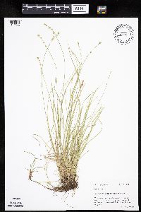 Carex radiata (Wahlenberg) Small 436788[1015286]Mason, Harriet; et al. NSP98-061998-05-13 United States, Minnesota, Rice, SW corner of sec. 16 in Nerstrand Big Woods State Park. Two-thirds the way north along the west boundary.;Nerstrand Woods State Park;110N;19W;16, 44.334371 -93.111203 |
MIN:Plants | 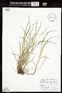 Carex woodii Dewey 493450[1018522]Zager, S.; et al. 960523-21996-05-05 United States, Minnesota, Fillmore, Fillmore County...In Shattuck Creek...T102N R08W SE1/4 of SE1/4 of SE1/4 of Section 06...MCBS Site F90;Dorer Memorial Hardwood State Forest;102N;08W;06, 43.666683 -91.839903 |
MIN:Plants |  Carex disperma Dewey 478232[1009868]Anderson, Craig 8632000-06-09 United States, Minnesota, Douglas, Douglas County ... Spruce Center WMA ... T130N R36W: 1/4 of SW1/4 of NE1/4 of Sect. 16;Spruce Creek Wildlife Management Area;130N;36W;16, 46.070448 -95.218593 |
MIN:Plants |  Carex podocarpa R. Brown ex Richardson 548545[1014854]Spetzman, L. s.n.1951-07-20 United States, Alaska, Arctic North Slope ... Katakturuk River, Ignek Valley;Arctic National Wildlife Refuge;;;, 69.5833333 -145.5833333, 610m |
MIN:Plants |  Carex podocarpa R. Brown ex Richardson 408271[1113561]Spetzman, L. 19361949-07-17 United States, Alaska, Arctic North Slope ... Kanayut Lake;Gates of the Arctic National Park;;;, 68.3333359 -151, 914m |
MIN:Plants |  Carex crawfordii Fernald 454843[1008893]Gerdes, Lynden; et al. 26441998-06-08 United States, Minnesota, Cook, Approx. 3/4 mile NE of Mayhew Lake; beaver drainage north of the hiking trail. NW1/4 SW1/4 of section;Boundary Waters Canoe Area Wilderness / Superior National Forest;065N;02W;26, 48.084268 -90.54412 |
MIN:Plants | Carex flava L. 477849[1109914]Gerdes, Lynden United States, Minnesota, Lake, Detailed locality information protected. This is typically done to protect rare or threatened species localities. |
MIN:Plants |  Carex grisea Wahlenberg 510111[1011105]Wheeler, Gerald 190891998-06-13 United States, Minnesota, Le Sueur, Chamberlain Woods Scientific Natural Area. Le Sueur County ... Ca. 2 mi. N of Ottawa; 0.7 mi. W of Rte. 36; Chamberlain Woods SNA ... bluff overlooking the Minnesota River valley ... W1/2 NW1/4 Sec. 22 T111N R26W (Ottawa 22). 111N 26W 22, 44.406012 -93.939414 |
MIN:Plants |  Carex nardina Fries 600038[1110990]Cooper, William 2041929-07-15 United States, Alaska, Glacier Bay;Glacier Bay National Park;;;, 58.797428 -136.838127 |
MIN:Plants |  Carex siccata Dewey 233196[1016341]Congdon, J. s.n.1899-08-28 United States, California, Mariposa, Indian Canon Camp, above Yosemite;Yosemite National Park |
MIN:Plants |  Carex stipata var. stipata Muhlenberg ex Willdenow 913917[1016756]Lee, Michael MDL39852005-06-22 United States, Minnesota, Becker, Becker County...moraine just east of Collet Lake, two miles south-southeast of Evergreen, six miles southwest of the town of Wolf Lake...T138N R38W NW1/4ofNW1/4SW1/4 Sec. 25; NE1/4ofNE1/4ofSE1/4 Sec. 26.. 138N 38W 0, 46.759757 -95.477627 |
MIN:Plants |  511102[1018110]Wheeler, Gerald 159361997-06-06 United States, Minnesota, Brown, Brown County ... Ca. 15 mi. NW of Sleepy Eye; 0.4 mi. NE of Rte. 10; Morgan Sportsman Club Recreation Area ... NE1/4 SW1/4 Sec. 19 T112N R33W (Eden 19). 112N 33W 19, 44.48977 -94.857039 |
MIN:Plants |  555482[1008522]Moir, D. 21831953-07-29 Canada, Ontario, Kenora, about 1-1/2 miles inland from coast ... Vicinity of the mouth of Black Duck River;;;;, 56.7761 -89.105082 |
MIN:Plants |  Carex chordorrhiza Ehrhart ex L. f. 476214[1009335]Smith, Welby 158281989-07-20 United States, Minnesota, Mille Lacs, Mille Lacs Kathio State Park. Mille Lacs County...Mille Lacs Kathio State Park, about 5 miles northwest of Onamia...NE1/4 SE1/4 sec. 10, T 42N R 27W. 042N 27W 10, 46.1336111 -93.7272222 |
MIN:Plants |  Carex gravida L.H. Bailey 429099[1011053]Juhnke, C. 338 CMJ FRO1999-06-09 United States, Minnesota, Goodhue, Frontenac State Park. Frontenac State Park Goodhue County ... Along Cty. Rd. 2 near woods 100 meters north of monument wayside on Hwy. 61 T112N R13W SW SE NW 13. 112N 13W 13, 44.505359 -92.319092 |
MIN:Plants |  Carex woodii Dewey 478969[1018528]Carlson, Bruce 008021999-07-07 United States, Minnesota, Mille Lacs, Mille Lacs Co.; Rum River State Forest. 7/8 mile east of the West Branch Groundhouse River; T040N R26W NWSW27;Rum River State Forest;040N;26W;27, 45.929789 -93.570875 |
MIN:Plants |  Carex oligosperma Michaux 454333[1013882]Lee, Michael MDL13821996-07-11 United States, Minnesota, Carlton, Fond du Lac Indian Reservation / Fond du Lac State Forest. Carlton County ... Fon du Lac [sic] State Forest. 4.5 miles west of Sawyer ... along HWY 210 ... T48N R19W NW1/4 SW1/4 SE1/4 Sec. 3. 048N 19W 3, 46.671595 -92.734595 |
MIN:Plants | 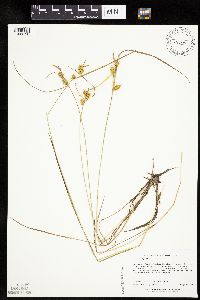 Carex cryptolepis Mackenzie 491481[1009190]Lee, Michael; et al. MDL27041999-09-01 United States, Minnesota, Lake, Finland State Forest. Lake County ... On the margin of Lookout Lake in the Finland State Forest, three miles north of Finland ... at south side of lake ... primitive landing in front of lone (old) cabin ... T58N R7W SW1/4 of NE1/4 of SE1/4 Sec. 32. 058N 07W 32, 47.465082 -91.246068 |
MIN:Plants | Carex media R. Brown ex Richardson 914785[1013469]Gerdes, Lynden; et al. United States, Minnesota, Cook, Detailed locality information protected. This is typically done to protect rare or threatened species localities. |
MIN:Plants |  Carex aquatilis Wahlenberg 905438[1006749]Gerdes, Lynden 47352003-07-02 United States, Minnesota, Lake, Superior National Forest. T58N R09W S32NWNE. Lake County...Superior National Forest. Crown Lake, approx. 4.06 miles SSW of Isabella, MN. Near the southwest corner of the lake.. 058N 09W 32, 47.465763 -91.502062 |
MIN:Plants | 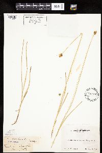 Carex pachystachya Chamisso ex Steudel 233452[1013961]Congdon, J. s.n.1899-08-27 United States, California, Tuolumne, Tuolumne Meadows, Tuolumne County;Yosemite National Park |
MIN:Plants | 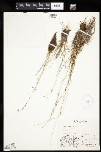 417344[1008487]Spetzman, L. 41241950-07-17 United States, Alaska, Arctic North Slope ... Noatak & Kugururok Rivers;Noatak National Preserve;;;, 67.9666672 -161.9166718, 152m |
MIN:Plants | 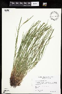 Carex oligocarpa Willdenow 511501[1013834]Wheeler, Gerald 188231998-06-04 United States, Minnesota, Sibley, Ca. 1 mi. WSW of jct. of Rte. 25 and Rte. 6. NW1/4 NW1/4 of section;;114N;25W;36, 44.632945 -93.776858 |
MIN:Plants | 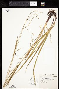 Carex gracillima Schweinitz 599315[1010827]Tryon, R. 9941935-06-21 United States, Indiana, Porter, Road at E end of Dunes State Park, Porter Co.;Indiana Dunes National Lakeshore;;;, 41.663093 -87.032128 |
MIN:Plants | Carex jamesii Schweinitz 477712[]Lee, Michael United States, Minnesota, Wabasha, Detailed locality information protected. This is typically done to protect rare or threatened species localities. |
MIN:Plants | Carex brunnescens subsp. sphaerostachya (Tuckerman) Kalela 436033[1008112]Smith, Michael 1171996-08-16 United States, Minnesota, Saint Louis, Voyageurs National Park. St. Louis County ... Plot name: Voya 14 DNR # 5772 ... Cranberry Bay;Voyageurs National Park;070N;21W;, 48.5672226 -93.043335 |
MIN:Plants | 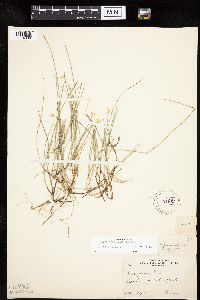 Carex pauciflora Lightfoot 221967[1014030]Cooper, William 311909-07-06 United States, Michigan, Keweenaw, Rock Harbor, Isle Royale;Isle Royale National Park |
MIN:Plants | 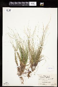 Carex eburnea Boott 283520[1010143]Moore, J.; et al. 35751931-07-22 United States, Texas, Culberson, Guadelupe Mountains. Culberson County ... McKittrick Canyon;Guadalupe Mountains National Park, 1980m |
MIN:Plants | 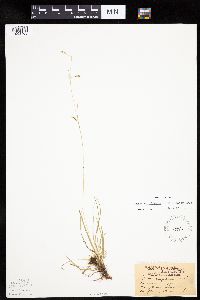 75964[1008468]Aiton, G. s.n.1891-06-00 United States, Minnesota, Clearwater, Lake Itasca;Itasca State Park;143N;36W;, 47.19557 -95.233216 |
MIN:Plants | 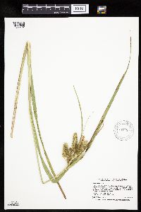 Carex comosa Boott 912350[1008732]Smith, Welby 230101993-07-21 United States, Minnesota, Meeker, Meeker County...At the north end of Little Swan Lake, about 3 mi north of Dassel...T 119N R 29W SW1/4 of NW1/4 of sec 11;;119N;29W;11, 45.1344444 -94.2919444 |
MIN:Plants | 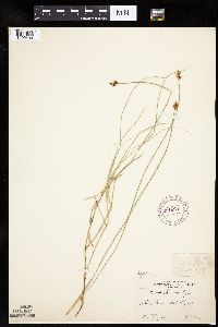 Carex chordorrhiza Ehrhart ex L. f. 221824[1009403]Cooper, William 1531909-07-22 United States, Michigan, Keweenaw, Tobins Harbor, Isle Royale;Isle Royale National Park |
MIN:Plants | 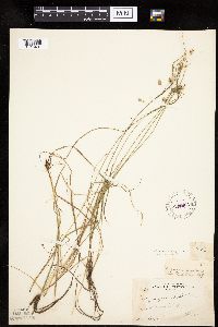 Carex magellanica subsp. irrigua (Wahlenburg) Hiitonen 221964[1013431]Cooper, William 3031909-08-06 United States, Michigan, Keweenaw, Near Rock Trail, Isle Royale;Isle Royale National Park |
MIN:Plants | Carex michauxiana Boeckeler 479341[1013603]Scott, P. United States, Minnesota, Lake, Detailed locality information protected. This is typically done to protect rare or threatened species localities. |
MIN:Plants | 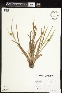 Carex granularis Muhlenberg ex Willdenow 508991[1110056]Wheeler, Gerald 189331998-06-06 United States, Minnesota, Redwood, Redwood County ... Ca. 4.5 mi. NE of Belview; 0.4 mi. E of jct. of Rte(s). 19 and 58 ... NE1/4 NE1/4 NW1/4 Sec. 27 T114N R37W (Swedes Forest 27). 114N 37W 27 |
MIN:Plants |  Carex pensylvanica Lamarck 599303[1014819]Tryon, R. 45891936-04-18 United States, Indiana, Porter, Indiana Dunes State Park, 3 miles N of Chesterton, Porter Co.;Indiana Dunes National Lakeshore;;;, 41.663093 -87.032128 |
MIN:Plants |  Carex pellita Willdenow 488916[1113350]Gerdes, Lynden 45602002-07-08 United States, Minnesota, Lake, T60N R09W S35NENW. Lake County...Fish Fry Pond, Isabella;Superior National Forest;060N;09W;35, 47.639221 -91.437962 |
MIN:Plants |  Carex echinodes (Fernald) Rothrock, Reznicek & Hipp 899194[1010280]Smith, Welby 256481995-06-03 United States, Minnesota, Carver, Carver County...On the N side of State Hwy 7, 0.5 mile W of its jct with State Hwy 25, and one mile N of the town of Mayer...T 117N R 25W SE1/4 of SW1/4 of Sec 30. 117N 25W 30, 44.9061111 -93.8813889 |
MIN:Plants |  Carex comosa Boott 454620[1008668]Lee, Michael MDL15081996-08-29 United States, Minnesota, Aitkin, Two miles north of Sheshebee. SE1/4 NW1/4 NE1/4 of section;Savanna State Forest;049N;23W;15, 46.731563 -93.244333 |
MIN:Plants |  Carex projecta Mackenzie 493151[1113647]Gerdes, Lynden; et al. 36461999-07-27 United States, Minnesota, Cook, T65N R03E S33SWNW Cook County ... Superior National Forest, John Lake area, BWCAW... west end of lake.;Boundary Waters Canoe Area Wilderness / Superior National Forest;065N;03E;33, 48.071844 -90.06797 |
MIN:Plants |  Carex diandra Schrank 914146[1009751]Lee, Michael MDL43972007-06-19 United States, Minnesota, Wadena, Wadena County...2.5 miles south of Nimrod...west of County Highway 26...T136N R33W W1/2 of NE1/4 of NE1/4 Sec. 18... UTM: 5162411N 355300E. 136N 33W 18, 46.593835 -94.894978 |
MIN:Plants |  Carex hystericina Muhlenberg ex Willdenow 504989[1011803]Lee, Michael MDL12821996-06-12 United States, Minnesota, Dakota, Dakota County ... Macalester College Field Station 2 miles north of Pine Bend ... along the Mississippi River at River Lake ... T27N R22W SW1/4 NW1/4 SW1/4 Sec. 23. 027N 22W 23, 44.809161 -93.006793 |
MIN:Plants |  Carex disperma Dewey 79824[1009963]Nelson, Aven; et al. 61131899-07-24 United States, Wyoming, Park, Obsidian Creek;Yellowstone National Park |
MIN:Plants |  Carex lacustris Willdenow 497588[1012309]Gerdes, Lynden; et al. 27331998-06-17 United States, Minnesota, Cook, Superior National Forest. T65N R04W S27NESE. Cook County ... Superior National Forest. Cross River, approx. 0.2 mile SE of the Gunflint Trail (Cty. 12) and Round Lake Road (Cty. 47) junction; north side of Cty 12.. 065N 04W 27, 48.084242 -90.825443 |
MIN:Plants | Carex michauxiana Boeckeler 914773[1110905]Gerdes, Lynden; et al. United States, Minnesota, Cook, Detailed locality information protected. This is typically done to protect rare or threatened species localities. |
MIN:Plants |  Carex aquatilis Wahlenberg 408374[1006848]Spetzman, L. 19691949-07-17 United States, Alaska, Arctic North Slope ... Kanayut Lake;Gates of the Arctic National Park;;;, 68.3333359 -151, 914m |
MIN:Plants |  Carex chordorrhiza Ehrhart ex L. f. 427337[1109419]Lee, Michael; et al. MDL21341998-06-16 United States, Minnesota, Wright, Wright Co.; floating mat severed by Hwy 55 on the southeast side of Maple Lake; T120N R26W SW1/4 of SW1/4 Sec. 4, NW1/4 of NW1/4 Sec. 9, SE1/4 of NE1/4 Sec. 8. 120N 26W , 45.194895 -93.951207 |
MIN:Plants |  Carex aquatilis Wahlenberg 79719[1006854]Wheeler, William 7271900-08-00 United States, Michigan, Keweenaw, Tobin's Harbor, Isle Royale;Isle Royale National Park |
MIN:Plants |  Carex podocarpa R. Brown ex Richardson 408330[1113563]Spetzman, L. 18211949-07-10 United States, Alaska, Arctic North Slope ... Anaktuvuk Pass.;Gates of the Arctic National Park;;;, 68.2833333 -151.4166667, 610m |
MIN:Plants |  Carex brunnescens subsp. sphaerostachya (Tuckerman) Kalela 435340[1008145]Boe, J. 970617031997-06-17 United States, Minnesota, Aitkin, North of Wolf Lake; In releve 97-03. SW1/4 of SW1/4 of section;Savanna Portage State Park;051N;22W;32, 46.86039 -93.154338 |
MIN:Plants |  Carex stricta Lamarck 903630[1017056]Smith, Welby 295612006-06-04 United States, Minnesota, Anoka, Lamprey Pass Wildlife Management Area. Anoka County...Lamprey Pass State Wildlife Management Area, about 2 miles SW of Forest Lake (town)...T32N R22W SW1/4 of NE1/4 of Sec 13. 032N 22W 13, 45.29 -93.1225 |
MIN:Plants |  Carex buxbaumii Wahlenberg 898254[1008282]Smith, Welby 291782001-06-13 United States, Minnesota, Pipestone, Pipestone County...Altona State Wildlife Management Area, about 2 mi SE of Verdi...T108N R46W NE1/4 of NW1/4 of Sec 1;Altona Wildlife Management Area;108N;46W;01, 44.1966667 -96.3219444 |
MIN:Plants |  Carex lacustris Willdenow 484283[1012420]Husveth, J. 96-0611996-05-31 United States, Minnesota, Hennepin, Hennepin County ... T118N R23W SW1/4 of the NE1/4 of S27;;118N;23W;27, 44.999919 -93.573712 |
MIN:Plants |  Carex magellanica subsp. irrigua (Wahlenburg) Hiitonen 921287[1013409]Lee, Michael MDL34252003-06-19 United States, Minnesota, Todd, Grey Eagle Wildlife Management Area. Todd County...Grey Eagle Wildlife Management Area...along Prairie Creek, 4.5 miles west of Grey Eagle...northwest of Bunker Lake...T127N R33W W1/2 of SW1/4 of SW1/4 Sec. 9. 127N 33W 9, 45.828659 -94.84209 |
MIN:Plants |  Carex projecta Mackenzie 493199[1015153]Gerdes, Lynden; Walewski, Joe W. 37541999-08-06 United States, Minnesota, Cook, Small pond approximately .25 mile southwest of the Gunflint Trail (Cty. 12) and Round Lake road (Cty. 47) junction. NWSE of section;Superior National Forest;065N;04W;27, 48.084242 -90.825443 |
MIN:Plants |  Carex molesta Mackenzie ex Bright 475233[1013658]Wheeler, Gerald 47091979-08-03 United States, Minnesota, Lac Qui Parle, Lac Qui Parle County .... Lac Qui Parle State Park ... slope overlooking the Minnesota River. T118N R42W Sec. 14;Lac Qui Parle State Park;118N;42W;14, 45.028651 -95.890681 |
MIN:Plants |  Carex fuliginosa Schkuhr 548523[1010650]Spetzman, L. 38641951-07-15 United States, Alaska, Arctic North Slope ... Canning R. & Ignek Cr.;Arctic National Wildlife Refuge;;;, 69.5833359 -146.25, 305m |
MIN:Plants |  Carex magellanica subsp. irrigua (Wahlenburg) Hiitonen 915033[1013374]Smith, Welby; et al. 314592009-09-10 United States, Minnesota, Cook, Boundary Waters Canoe Area Wilderness / Superior National Forest. Cook County...Boundary Waters Canoe Area Wilderness, Superior National Forest...just north of John Lake...T64N R3E NE1/4 of NE1/4 of Sec 33. 064N 03E 33, 47.9886111 -90.0597222 |
MIN:Plants |  Carex fuliginosa Schkuhr 408266[1109959]Spetzman, L. 18191949-07-10 United States, Alaska, Arctic North Slope ... Anaktuvuk Pass;Gates of the Arctic National Park;;;, 68.2833333 -151.4166667, 610m |
MIN:Plants |  Carex sprengelii Dewey ex Sprengel 907787[1016525]Smith, Welby 308902008-06-12 United States, Minnesota, Benton, Michaelson Farm Wildlife Management Area. Benton County ... Michaelson Farm State Wildlife Management Area, about 2 miles S-SW of Rice ... T38N R31W SW1/4 of SE1/4 of Sec 32. 038N 31W 32, 45.7377778 -94.2233333 |
MIN:Plants |  Carex backii W. Boott 432318[1007256]Lee, Michael MDL27342000-06-21 United States, Minnesota, Lake, Superior National Forest. Lake County...Superior National Forest two miles north-northeast of Cramer...above Paccini Lake...T59N R6W NW1/4 of NE1/4 Sec. 34.. 059N 06W 34, 47.551556 -91.07583 |
MIN:Plants |  Carex vaginata Tausch 915858[1018064]Whitfeld, T.J.S. 6712006-06-08 United States, Minnesota, Hubbard, Paul Bunyan State Forest. Hubbard County...3/4 mile northeast of West Gulch Forest Trail; 1/4 mile north of Gulch Creek...UTM (NAD83): E362136 N5226138. 143N 33W 26, 47.1741667 -94.8188889 |
MIN:Plants |  490510[1010220]Lee, Michael MDL26281999-07-28 United States, Minnesota, Lake, Lake County...Seven miles northeast of Toimi...south of Alseth Lake...T58N R11W NE1/4 of NE1/4 Sec. 36;Superior National Forest;058N;11W;36, 47.466158 -91.666551 |
MIN:Plants |  Carex blanda Dewey 903362[1007596]Smith, Welby 295402006-06-02 United States, Minnesota, Wright, Wright County...Ney County Park, about two miles north of Maple Lake (town)...T121N R26W SE1/4 of NE1/4 of Sec 30;Ney County Park;121N;26W;30, 45.2627778 -93.9969444 |
MIN:Plants |  221924[1018187]Cooper, William 3111909-08-23 United States, Michigan, Keweenaw, Passage Id, Isle Royale;Isle Royale National Park |
MIN:Plants |  Carex foenea Willdenow 488176[1010544]Gerdes, Lynden 46942003-06-11 United States, Minnesota, Lake, Superior National Forest. T60N R06W S32NENW. Lake County...Superior National Forest. Charity Lake area, approximately 11.16 miles ENE of Isabella, MN and 0.11 miles south of Charity Lake. Southwestern knob of two topped rock outcrop feature.. 060N 06W 32, 47.637686 -91.1185 |
MIN:Plants | Carex ormostachya Wiegand 437934[1013956]Lee, Michael United States, Minnesota, Lake, Detailed locality information protected. This is typically done to protect rare or threatened species localities. |
MIN:Plants |  Carex richardsonii R. Brown 919470[1015533]Smith, Welby 221271993-05-19 United States, Minnesota, Becker, Becker County...Two Inlets State Forest; 7 miles northeast of Ponsford...T141N R36W NW1/4 of SE1/4 of Sec 16;Two Inlets State Forest;141N;36W;16, 47.025 -95.2425 |
MIN:Plants |  Carex woodii Dewey 492527[1118786]Lee, Michael MDL8071994-08-12 United States, Minnesota, Fillmore, Fillmore County ... Along Spring Valley Creek 1-1/2 miles northwest of Wykoff ... T 103N R 12W NE1/4 of SE1/4 of Sec 17;Dorer Memorial Hardwood State Forest / Wykoff Balsam Fir Scientific Natural Area;103N;12W;17, 43.724807 -92.299345 |
MIN:Plants |  Carex gynandra Schweinitz 904670[1011251]Gerdes, Lynden 45142001-09-27 United States, Minnesota, Lake, North Shore. T56N R07W S16NENE. Lake County...Silverr Bay, MN. Just outside the Tettegouche State Park boundary. Snowmobile trail, approximately 1.1 mile west of the State Park Headquarters.. 056N 07W 16, 47.336179 -91.229406 |
MIN:Plants |  Carex gynandra Schweinitz 493446[1011231]Lee, Michael MDL30222001-07-12 United States, Minnesota, Lake, North Shore. Lake County ... Along the shore of Lake Superior at Little Marais, 1/2 mile southwest of the mouth of the Little Marais River ... T57N R6W NW1/4 of SW1/4 of NW1/4 Sec.21 (small, irregular section). 057N 06W 21, 47.413976 -91.102986 |
MIN:Plants |  Carex umbellata Schkuhr ex Willdenow 511495[1017786]Wheeler, Gerald 171071997-08-11 United States, Minnesota, Chippewa, Chippewa County ... Ca. 2.2 mi. SE of Granite Falls, E of Pete's Pt. Rd. SE ... W1/2 SE1/4 SW1/4 Sec. 12 T115N R39W;;115N;39W;12, 44.781521 -95.492683 |
MIN:Plants |  508993[1018132]Lee, Michael MDL20611998-05-24 United States, Minnesota, Cook, Boundary Waters Canoe Area Wilderness / Superior National Forest. Cook County ... Boundary Waters Canoe Area Wilderness. Saganaga Lake ... Red Rock Bay ... T66N R5W Sec. 22, NW1/4 Sec. 27, NE1/4 Sec. 28. 066N 05W , 48.185424 -90.95709 |
MIN:Plants |  Carex jonesii L.H. Bailey 232748[1012279]Congdon, J. s.n.1898-08-01 United States, California, Mariposa, Chilnualna Falls, Mariposa County;Yosemite National Park |
MIN:Plants |  Carex rariflora (Wahlenberg) Smith 408746[1113723]Spetzman, L. s.n.1949-07-15 United States, Alaska, Arctic North Slope ... Anaktuvuk Pass;Gates of the Arctic National Park;;;, 68.2833333 -151.4166667, 610m |
MIN:Plants | Carex hallii Olney 588220[1011351]Willard, B. United States, Colorado, Larimer, Detailed locality information protected. This is typically done to protect rare or threatened species localities. |
MIN:Plants |  Carex tetanica Schkuhr 473207[1017390]Nation, R. 94-0391994-05-26 United States, Minnesota, Mower, Lake Louise State Park. Mower Co.; Tract 1A. T101N R14W NW1/4 of SW1/4 of Sec. 21;Lake Louise State Park;101N;14W;21, 43.536578 -92.519043 |
MIN:Plants |  Carex NULL 79541[1106829]Conard, Henry 1721902-06-26 United States, Washington, Grays Harbor, trail, 1/4 m. W. of Quiniault [sic];Olympic National Park;;;, 47.468093 -123.84669 |
MIN:Plants |  Carex merritt-fernaldii Mackenzie 221968[1013561]Cooper, William 51909-07-03 United States, Michigan, Keweenaw, McCargoes, Isle Royele;Isle Royale National Park |
MIN:Plants | Carex sterilis Willdenow 910120[1016698]Rowe, Erika United States, Minnesota, Becker, Detailed locality information protected. This is typically done to protect rare or threatened species localities. |
MIN:Plants |  906398[1010217]Gerdes, Lynden; et al. 50202005-07-12 United States, Minnesota, Saint Louis, Superior National Forest. T58N R12W S31NWNW. St. Louis County...Superior National Forest. SE of Skibo, MN. Approx. 1.60 miles SW of Stone Lake on the south side of river.. 058N 12W 31, 47.466934 -91.907768 |
MIN:Plants |  Carex conoidea Willdenow 473138[1008777]Nation, R. 94-0091994-05-26 United States, Minnesota, Mower, Tract #13S. SE1/4 of SE1/4 of Sec;Lake Louise State Park;101N;14W;21, 43.536578 -92.519043 |
Google Map
Google Maps is a web mapping service provided by Google that features a map that users can pan (by dragging the mouse) and zoom (by using the mouse wheel). Collection points are displayed as colored markers that when clicked on, displays the full information for that collection. When multiple species are queried (separated by semi-colons), different colored markers denote each individual species.