University of Minnesota
http://www.umn.edu/
612-625-5000
http://www.umn.edu/
612-625-5000
Minnesota Biodiversity Atlas
Bell Museum
Dataset: MIN-Plants
Taxa: Carex
Search Criteria: excluding cultivated/captive occurrences
Bell Museum plants | |
 MIN:Plants |  Carex petasata Dewey 621831[1014827]Weber, W.; Grove, T. 140761970-07-08 United States, Colorado, Rocky Mountain National Park ... inside the park entrance east of Horseshoe Park.;Rocky Mountain National Park |
MIN:Plants |  Carex brunnescens subsp. sphaerostachya (Tuckerman) Kalela 454950[1008074]Gerdes, Lynden 26661998-06-11 United States, Minnesota, Cook, T65N R01W S34SWNW. Cook County ... Superior National Forest. Caribou Rock Hiking trail, N of NW end of West Bearskin Lak;Superior National Forest;065N;01W;34, 48.069863 -90.438211 |
MIN:Plants |  Carex arcta Boott 906382[1006884]Gerdes, Lynden 50432005-07-26 United States, Minnesota, Saint Louis, Superior National Forest. T60N R12W S25SESESW. St. Louis County...Superior National Forest. SE of Babbit, MN. Small unnamed pond, approx. 3.27miles south down FR 112 from its junction with FR 434. East side of FR 112.. 060N 12W 25, 47.651272 -91.805106 |
MIN:Plants |  400843[1015958]Spetzman, L. 8761948-07-29 United States, Alaska, Arctic North Slope...Sadlerochit River;Arctic National Wildlife Refuge;;;, 69.4166667 -149.1666667, 762m |
MIN:Plants |  Carex gracillima Schweinitz 221933[1010828]Cooper, William 3731909-08-18 United States, Michigan, Keweenaw, Sargent Lake trail, Isle Royale;Isle Royale National Park |
MIN:Plants |  Carex retrorsa Schweinitz 510731[1015384]Wheeler, Gerald 190001998-06-10 United States, Minnesota, Scott, Minnesota Valley National Wildlife Refuge. Scott County ... Ca. 4.5 mi. NNE of Jordan; 1.1 mi W of Rte. 169. Louisville Swamp; Adjacent to Mazomani Trail ... E1/2 NW1/4 Sec. 33 T115N R23W (Louisville 33). 115N 23W 33, 44.725651 -93.592284 |
MIN:Plants |  Carex foenea Willdenow 221959[1010629]Cooper, William 831909-07-11 United States, Michigan, Keweenaw, Rock Harbor, Isle Royale;Isle Royale National Park |
MIN:Plants |  Carex utriculata Boott in W.J. Hooker 907088[1017871]Smith, Welby; et al. 310202008-07-21 United States, Minnesota, Saint Louis, Boundary Waters Canoe Area Wilderness / Superior National Forest. St. Louis County...In a small bay at the northwest end of Fountain Lake in the Boundary Waters Canoe Area Wilderness Superior National Forest...T 65N R 12W SW1/4 of SE1/4 of Sec 24. 065N 12W 24, 48.0958333 -91.8058333 |
MIN:Plants | 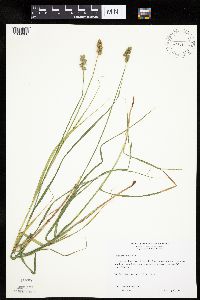 Carex cristatella Britton 492382[1009066]Wheeler, Gerald 165701997-07-17 United States, Minnesota, Stearns, Stearns County ... Ca. 6 mi. N of Melrose; Birch Lakes State Forest ... NE1/4 SW1/4 Sec. 36 T127N R33W;Birch Lakes State Forest;127N;33W;36, 45.766948 -94.777658 |
MIN:Plants | 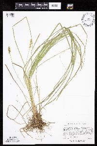 Carex arcta Boott 498983[1006896]Lee, Michael MDL31232001-09-18 United States, Minnesota, Lake, Superior National Forest. Lake County ... Superior National Forest ... Between Thunderbird and Shoepack Lakes, 4 1/2 miles north-northwest of Cramer ... Just east of Shoepack Lake ... T59N R6W NW1/4 of SE1/4 of NE1/4 Sec. 17. 059N 06W 17, 47.594586 -91.118039 |
MIN:Plants | 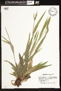 Carex albursina E. Sheldon 913543[1106871]Smith, Welby 228811993-07-14 United States, Minnesota, Sibley, Vale Wildlife Management Area. Sibley County...Vale State Wildlife Management Area, ca 2.5 miles N-NW of Henderson; in the valley of High Island Creek, ca 2.5 miles SW of its confluence with the Minn R...T 113N R 26W NE1/4 of SW1/4 of Sec 27. 113N 26W 27, 44.5625 -93.9427778 |
MIN:Plants | 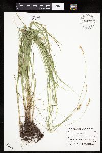 Carex tenera var. tenera Dewey 920830[1017233]Smith, Welby 172661990-07-17 United States, Minnesota, Morrison, Between East Boundary Road and the Mississippi River. UTM: 394800E 5107700N. SE1/4 of NW1/4 of section;Camp Ripley Military Reservation;131N;30W;32, 46.1147669 -94.3614283 |
MIN:Plants | 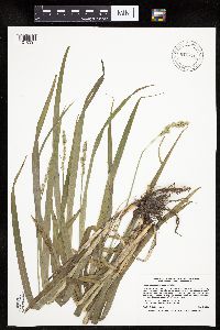 Carex sparganioides Muhlenberg ex Willdenow 916876[1016397]Smith, Welby 223251993-06-03 United States, Minnesota, Sibley, Vale Wildlife Management Area. Sibley County...Vale State Wildlife Management Area; in the valley of High Island Creek, about 2.5 miles southwest of its confluence with the Minnesota River ... T113N R26W NE1/4 of SW1/4 of Sec 27. 113N 26W 27, 44.5625 -93.9427778 |
MIN:Plants | Carex obtusata Liljeblad 400781[1013830]Spetzman, L. United States, Alaska, Detailed locality information protected. This is typically done to protect rare or threatened species localities. |
MIN:Plants | 477491[1012553]Smith, Welby United States, Minnesota, Winona, Detailed locality information protected. This is typically done to protect rare or threatened species localities. |
MIN:Plants | 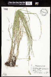 Carex normalis Mackenzie 477016[1013748]Smith, Welby 168911990-06-18 United States, Minnesota, Waseca, Goose Lake County Park. Waseca County ... Goose Lake County Park; at the southwest end of Goose Lake, about 2 miles east of Waseca ... T 107N R 22W NW1/4 of SW1/4 of Sec 14. 107N 22W 14, 44.0705556 -93.4436111 |
MIN:Plants | 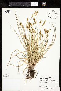 Carex foenea Willdenow 431300[1010553]Lee, Michael MDL27252000-06-12 United States, Minnesota, Lake, Lake County...along the Superior Hiking Trail 4-1/2 miles east of Finland...T57N R7W N1/2 of SE1/4 of NE1/4 Sec. 13;North Shore;057N;07W;13, 47.422384 -91.161398 |
MIN:Plants | 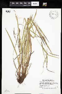 Carex granularis Muhlenberg ex Willdenow 912340[1010917]Smith, Welby 229111993-07-14 United States, Minnesota, Sibley, Sibley County... On the north side of Indian Lake, about 4 miles west of Gaylord... T113N R29W NW1/4 of SW1/4 of Sec 21;;113N;29W;21, 44.5791667 -94.3341667 |
MIN:Plants |  Carex oligosperma Michaux 906062[1013917]Lee, Michael MDL37062004-07-02 United States, Minnesota, Becker, White Earth Indian Reservation. Becker County...On a large island on the western side of Big Rush Lake, three miles northwest of the town of Pine Point...T141N R38W SW1/4 of SE1/4 Sec. 24. 141N 38W 24, 47.01374 -95.434589 |
MIN:Plants |  Carex lupulina Willdenow 921223[1013212]Lee, Michael MDL34572003-07-15 United States, Minnesota, Todd, Todd County...Along the Crow Wing River 1/2-mile downstrema from the Wadena County line, three miles east of downtown Staples...west side of the river...T133N R32W NE1/4 of SW1/4 Sec. 4. 133N 32W 4, 46.360578 -94.733082 |
MIN:Plants |  Carex sprengelii Dewey ex Sprengel 921245[1118135]Lee, Michael MDL34032003-06-13 United States, Minnesota, Todd, Oak Ridge Wildlife Management Area. Todd County...Oak Ridge Wildlife Management Area...between Mound and Cedar Lakes, four miles east of Grey Eagle... southeast of Stump Lake...T127N R32W SE1/4 of SE1/4 of NW1/4 Sec. 12. 127N 32W 12, 45.824273 -94.65419 |
MIN:Plants |  Carex pensylvanica Lamarck 426930[1014805]Rowe, Erika ERR282004-07-09 United States, Minnesota, Becker, Becker County...1/2 mile north of the Becker/Ottertail county line; 3-1/2 miles west of Frazee...near a power line cut...T138N R41W NWSE36. 138N 41W 36, 46.723836 -95.805612 |
MIN:Plants |  Carex oligosperma Michaux 251088[1013940]Umbach, L. s.n.1900-06-16 United States, Indiana, Porter, Dune Park;Indiana Dunes National Lakeshore;;;, 41.663093 -87.032128 |
MIN:Plants |  Carex NULL 484096[1106814]Kaul, R. 67241990-05-02 United States, Minnesota, Jackson, Jackson County ... above the Des Moines River, Kilen Woods.;Kilen Woods State Park;103N;35W;, 43.717588 -95.034813 |
MIN:Plants | Carex exilis Dewey 454415[1010459]Lee, Michael United States, Minnesota, Lake, Detailed locality information protected. This is typically done to protect rare or threatened species localities. |
MIN:Plants |  Carex magellanica Lamarck 456485[1013372]Lee, Michael MDL17651997-06-25 United States, Minnesota, Stearns, Stearns Co.; 2-1/2 miles west-southwest of St. Stephen; T126N R29W NW1/4 of SW1/4 Sec. 27;;126N;29W;27, 45.695687 -94.315637 |
MIN:Plants |  Carex siccata Dewey 439037[1016218]Gerdes, Lynden 48322004-05-26 United States, Minnesota, Lake, Superior National Forest. T60N R10W S27SESE. Lake County...Superior National Forest. Approximately 10.8 miles WNW of Isabella, MN. Sandy mixed upland west and north of Stony River.. 060N 10W 27, 47.654294 -91.586637 |
MIN:Plants |  Carex eburnea Boott 461205[1010098]Harris, Fred 960081996-05-09 United States, Minnesota, Sibley, Sibley Co.; ravine on edge of High Island Creek valley 2 miles north of Henderson; T 113N R 26W NE1/4 of SE1/4 of Sec 28;;113N;26W;28, 44.564981 -93.9602 |
MIN:Plants | Carex aperta Boott in W.J. Hooker 75306[]Cusick, W. 29911902-08-14 United States, Oregon, Summit of the Cascades [Mts.] |
MIN:Plants |  Carex pauciflora Lightfoot 511433[1014026]Carlson, Bruce 005311998-07-30 United States, Minnesota, Mille Lacs, Mille Lacs Kathio State Park. Mille Lacs Co. ... Mille Lacs Kathio State Park, 0.5 miles WNW of the Stark Road dead end. DNR Releve 7645 voucher. T42N R27W NESW21. 042N 27W 21, 46.106434 -93.755805 |
MIN:Plants |  Carex nigromarginata Schweinitz 461670[1013746]Hyatt, Philip 58461994-04-10 United States, Arkansas, Searcy, Searcy Co. ... Buffalo National River, T16N, R15W, S4, NW4ofNE4. Bluff top south of Arkansas Hwy 14 & bridge;Buffalo National River;016N;15W;04 |
MIN:Plants |  Carex podocarpa R. Brown ex Richardson 408732[1014847]Spetzman, L. 10101948-08-03 United States, Alaska, Arctic North Slope...Sadlerochit River;Arctic National Wildlife Refuge;;;, 69.5 -145, 610m |
MIN:Plants |  Carex deflexa var. deflexa Hornemann 907594[1009283]Gerdes, Lynden 53942007-06-11 United States, Minnesota, Lake, Superior National Forest. T61N R08W S19NESE Lake County ... Superior National Forest. Approximately 9.0 miles NNW of Isabella ... ~0.21 miles east of the Northwest Road (FR373) ... NAD 83 / 621027 / 5289593. 061N 08W 19, 47.7483333 -91.3852778 |
MIN:Plants |  Carex rostrata Stokes 599673[1015825]Cooper, William 711935-07-30 United States, Alaska, Glacier Bay, Station 7E.;Glacier Bay National Park;;;, 58.607862 -135.84184 |
MIN:Plants |  Carex nardina Fries 548599[1013727]Spetzman, L. 36851951-07-20 United States, Alaska, Arctic North Slope ... Katakturuk River, Ignek Valley;Arctic National Wildlife Refuge;;;, 69.5833359 -145.5833282, 610m |
MIN:Plants |  Carex assiniboinensis W. Boott 912886[1006968]Smith, Welby 240701994-05-10 United States, Minnesota, Yellow Medicine, Upper Sioux Agency State Park. Yellow Medicine County...Upper Sioux Agency State Park, about 7 miles southwest of Sacred Heart; in the Minnesota River Valley...T 115N R 38W SE1/4 of SE1/4 of Sec 29. 115N 38W 29, 44.735 -95.4425 |
MIN:Plants |  Carex diandra Schrank 914232[1009752]Lee, Michael MDL39472005-06-09 United States, Minnesota, Becker, Two Inlets State Forest. Becker County...Two Inlets State Forest. In peatland northeast of One Acre Lake and southeast of Ten Acre Lake, 3 3/4 miles south-southeast of Two Inlets...T141N R36W SW1/4 of NE1/4 of SE1/4 Sec. 26. 141N 36W 26, 46.99982 -95.201476 |
MIN:Plants |  897110[1109345]Zager, S. 116a2004-06-25 United States, Minnesota, Roseau, Roseau County...T 161 N R 37W 1/4 of 1/4 SENE Section 29;Beltrami Island State Forest;161N;37W;29, 48.7361111 -95.44 |
MIN:Plants |  Carex assiniboinensis W. Boott 437799[1006957]Smith, Welby 166571990-05-21 United States, Minnesota, Waseca, Goose Lake County Park. Waseca County ... Goose Lake County Park; at the southwest end of Goose Lake, about 2 miles east of Waseca ... T107N R22W NW1/4 of SW1/4 of Sec 14. 107N 22W 13, 44.0705556 -93.4436111 |
MIN:Plants |  Carex aquatilis Wahlenberg 599674[1006851]Cooper, William 741935-07-30 United States, Alaska, Glacier Bay, Station 7E.;Glacier Bay National Park;;;, 58.607862 -135.84184 |
MIN:Plants |  Carex radiata (Wahlenberg) Small 903648[1015304]Smith, Welby 295552006-06-04 United States, Minnesota, Anoka, about 2 miles SW of Forest Lake (town)...SW1/4 of NE1/4 of Sec ;Lamprey Pass Wildlife Management Area;032N;22W;13, 45.29 -93.1225 |
MIN:Plants | Carex pensylvanica Lamarck 477692[]Gerdes, Lynden 39582000-06-04 United States, Minnesota, Lake, T56N R07W S07SWNW. Lake County ... Tettegouche State Park. Approx. 0.25 mile NW of Tettegouche Lake adjacent to etc.;North Shore / Tettegouche State Park;056N;07W;07, 47.350541 -91.272185 |
MIN:Plants |  Carex assiniboinensis W. Boott 907592[1006973]Gerdes, Lynden 54462007-06-28 United States, Minnesota, Itasca, Chippewa National Forest / Leech Lake Indian Reservation. T146N R27W S11SWNW. Itasca County, MN. Leech Lake Reservation. Chippewa National Forest. Battle Point NRA. Approximately 0.04 miles north of the Bowens Road (Cty. Rd. 148) and just east of the access trail...NAD83 / 418997 / 5258928. 146N 27W 11, 47.476534 -94.066235 |
MIN:Plants |  Carex assiniboinensis W. Boott 435809[1006963]Judziewicz, E. 106391993-06-09 United States, Minnesota, Pine, Saint Croix State Park. Pine Co.; T40N-R18W, sec. 14, NE of SE. St. Croix State Park; on bank of St. Croix River opposite the mouth of the Clam River.. 040N 18W 14, 45.95558 -92.560512 |
MIN:Plants |  Carex emoryi Dewey 913587[1109868]BioBlitz volunteers s.n.2009-06-13 United States, Minnesota, Ramsey, Ramsey Co, St. Paul, Crosby Farm Regional Park, north side of the Mississippi River. T28N R13W Sec. 22;Hidden Falls - Crosby Farm Regional Park;028N;23W;22, 44.896902 -93.16521 |
MIN:Plants |  Carex vaginata Tausch 539819[1018091]Viereck, Les 17201956-08-05 United States, Alaska, Denali National Park. Mt. McKinley Nat. Park ... River bar on the north side of the McKinley River, 1-2 mi. S. of Wonder Lake (known locally as McKinley Bar or Big Timber). , 63.4166679 -150.75, 579m |
MIN:Plants |  Carex echinata Murray 79688[1010249]Wheeler, William 8241900-08-00 United States, Michigan, Keweenaw, Tobin's Harbor, Isle Royele;Isle Royale National Park |
MIN:Plants |  Carex blanda Dewey 913603[1109104]Smith, Welby 227981993-07-09 United States, Minnesota, Faribault, Faribault County...On the south side of Interstate 90, about one mile northwest of Blue Earth...along Blue Earth River...T 102N R 27W SE1/4 of SW1/4 Section 6. 102N 27W 6, 43.6597222 -94.1186111 |
MIN:Plants |  Carex eburnea Boott 509662[1010112]Wheeler, Gerald 193501998-06-23 United States, Minnesota, Carver, Carver County ... Ca. 4 mi. SSW of East Union; between Kelly Lake and Hallquist Lake ... SW1/4 NE1/4 Sec. 21 T114N R24W;;114N;24W;21, 44.663581 -93.712406 |
MIN:Plants |  Carex communis var. communis L.H. Bailey 461933[1009407]Lee, Michael MDL25351999-07-06 United States, Minnesota, Lake, Lake County ... two miles eat-northeast of Finland ... T57N R7W NW1/4 of NE1/4 of NW1/4 Sec. 15;;057N;07W;15, 47.42219 -91.203798 |
MIN:Plants |  Carex cusickii Mackenzie ex Piper & Beattie 359545[1009246]Mason, Herbert 119231938-07-10 United States, California, Tuolumne, Yosemite National Park ... South island in Swamp Lake, west of Hetch Hetchy ... Tuolumne County;Yosemite National Park, 1585m |
MIN:Plants |  Carex projecta Mackenzie 477765[1015052]Gerdes, Lynden 41492000-07-26 United States, Minnesota, Lake, North Shore / Wolf Ridge Environmental Center. T57N R07W S34NESE. Lake County ... Wolf Ridge Environmental Learning Center, Finland, MN. West side of Wolf Lake near wetland study site.. 057N 07W 34, 47.378962 -91.203696 |
MIN:Plants |  Carex granularis Muhlenberg ex Willdenow 913602[1010935]Smith, Welby 228101993-07-12 United States, Minnesota, Freeborn, Freeborn County...Between CSAH 46 and the Soo Line Railroad tracks, about 8 miles east of Albert Lea...T 102N R 20W NW1/4 or SW1/4 of Section 1. T102N R20W S1, 43.666432 -93.179093 |
MIN:Plants |  Carex projecta Mackenzie 477836[1015057]Gerdes, Lynden 40412000-07-12 United States, Minnesota, Lake, North Shore. T57N R06W S19NWSW. Lake County ... Little Marais, MN. Small, isolated, ash [tree] pocket approx. 1/2 miles ESE Superior Hiking Trail and County 6 junction. Approx. 0.85 mile ESE of the Finland Cemetary.. 057N 06W 19, 47.408042 -91.140007 |
MIN:Plants |  Carex hassei L.H. Bailey 600050[1011352]Cooper, William 1421929-07-10 United States, Alaska, Glacier Bay, Station 27.;Glacier Bay National Park;;;, 58.797428 -136.838127 |
MIN:Plants |  Carex feta L.H. Bailey 233451[1010483]Congdon, J. s.n.1891-07-21 United States, California, Mariposa, Big Trees, Mariposa County;Yosemite National Park |
MIN:Plants |  Carex nebrascensis Dewey 447788[1118810;1277139]Bright, R.C. 73-3381973-00-00 United States, Idaho, Franklin, [no further data] |
MIN:Plants |  Carex NULL 233175[1106847]Congdon, J. s.n.1890-08-18 United States, California, Tuolumne, Soda Springs, Tuolumne Co.;Yosemite National Park |
MIN:Plants |  Carex utriculata Boott in W.J. Hooker 921162[1118555]Smith, Welby 231461993-07-28 United States, Minnesota, Grant, Berskow Wildlife Management Area. Grant County ... Berskow State Wildlife Management Area. On the northeast side of Thorstad Lake, about 5 miles east of Elbow Lake (town) ... T129N R41W NW1/4 of NW1/4 of Sec 17. 129N 41W 17, 45.9905556 -95.8716667 |
MIN:Plants |  Carex blanda Dewey 477579[1007590]Lee, Michael MDL12811996-06-12 United States, Minnesota, Dakota, Dakota County ... Macalester College Field Station 2 miles north of Pine Bend ... along the Mississippi River at River Lake ... T27N R22W SW1/4 NW1/4 SW1/4 Sec. 23. 027N 22W 23, 44.809161 -93.006793 |
MIN:Plants |  Carex cryptolepis Mackenzie 455114[1009182]Gerdes, Lynden 30691998-07-31 United States, Minnesota, Cook, T65N R02W S30SESE. Cook County ... Superior National Forest. North shore of Little Mayhew Lake.;Superior National Forest;065N;02W;30, 48.084458 -90.630526 |
MIN:Plants | Carex michauxiana Boeckeler 778154[1013620]Coffin, Barbara; Engstrom, D. United States, Wisconsin, Ashland, Detailed locality information protected. This is typically done to protect rare or threatened species localities. |
MIN:Plants |  Carex duriuscula C.A. Meyer 901001[1009982]Lee, Michael MDL39262005-06-02 United States, Minnesota, Todd, TODD COUNTY ... North of Feucht Lake, four miles west-northwest of Grey Eagle ...T128N R33W SE1/4 of SE1/4 Sec. 33;;128N;33W;33, 45.853603 -94.838718 |
MIN:Plants |  Carex scoparia var. scoparia Schkuhr ex Willdenow 473106[1113979]Nation, R. 94-4371994-06-21 United States, Minnesota, Mower, Lake Louise State Park. Mower Co.; Tract #13N. T101N R14W NE1/4 of SE1/4 of Sec. 21;Lake Louise State Park;101N;14W;21, 43.536578 -92.519043 |
MIN:Plants |  Carex subfusca W. Boott 233345[1017082]Congdon, J. s.n.1899-08-28 United States, California, Mariposa, Indian Canyon Camp, above Yosemite;Yosemite National Park |
MIN:Plants | Carex michauxiana Boeckeler 916518[1013581]Anderson, Chel United States, Minnesota, Cook, Detailed locality information protected. This is typically done to protect rare or threatened species localities. |
MIN:Plants |  Carex pellita Willdenow 902913[1113340]Smith, Welby 296562006-07-07 United States, Minnesota, Wright, Suconnix Wildlife Management Area. Wright County...Succonix State Wildlife Management Area, about 5 miles south of Clearwater...T122N R27W SE1/4 of SW1/4 of sec 26. 122N 27W 26, 45.3430556 -94.0494444 |
MIN:Plants |  Carex crawfordii Fernald 915058[1008983]Smith, Welby; et al. 313822009-08-26 United States, Minnesota, Cook, Boundary Waters Canoe Area Wilderness / Superior National Forest. Cook County...Boundary Waters Canoe Area Wilderness, Superior National Forest. About 1/4 mile south of Winchell Lake along the outlet of Tremble Lake...T 64N R 2W SW1/4 of NE1/4 of Sec 32. 064N 02W 32, 47.9863889 -90.6041667 |
MIN:Plants |  Carex pedunculata Muhlenberg ex Willdenow 435364[1014301]Wheeler, Gerald 156821997-05-23 United States, Minnesota, Renville, Renville Co.; Ca. 15 mi. S of Danube on Rte. 1, W of road; NW1/4 NE1/4 SW1/4 Sec. 20 T113N R35W (Beaver Falls 20);;113N;35W;20, 44.578346 -95.085406 |
MIN:Plants |  Carex nudata W. Boott 234237[1006722]Congdon, J. s.n.1899-08-28 United States, California, Mariposa, Indian Canyon Camp, above Yosemite;Yosemite National Park |
MIN:Plants |  Carex interior L.H. Bailey 480589[1110434]Smith, Welby 171861990-07-11 United States, Minnesota, Dodge, Wasioja Wildlife Management Area. Dodge County ... In Wasioja State Wildlife Management Area, about 4 miles west of Wasioja ... T 107N R 17W SE1/4 of SW1/4 of Sec 17. 107N 17W 17, 44.0672226 -92.8916702 |
MIN:Plants |  Carex lenticularis Michaux 233786[1012768]Congdon, J. s.n.1898-08-01 United States, California, Mariposa, Chilnualna Trail, Mariposa County;Yosemite National Park |
MIN:Plants |  Carex NULL 472690[1106811]Nation, R. 94-0301994-05-26 United States, Minnesota, Mower, Lake Louise State Park. Mower County ... Tract 1A. T101N R14W NW1/4 of SW1/4 of Sec. 21;Lake Louise State Park;101N;14W;21, 43.536578 -92.519043 |
MIN:Plants |  Carex vulpinoidea Michaux 461751[1018343]Wheeler, Gerald 172501997-08-15 United States, Minnesota, Yellow Medicine, Yellow Medicine Co.; S side of Granite Falls, Memorial Park; on S bank of Minnesota River. S1/2 NE1/4 NW1/4 Sec. 3 T115N R39W (Minnesota Falls 3). 115N 39W 3, 44.795997 -95.533931 |
MIN:Plants |  Carex aurea Nuttall 919268[1007192]Perry, Ethan 090102009-07-10 United States, Minnesota, Cass, Cass County...On Itasca County lin 1.75 miles S of Mississippi R. ...T143N R25W SE1/4 of SE1/4 of Sec24;Chippewa National Forest;143N;25W;24, 47.1816667 -93.7747222 |
MIN:Plants |  Carex utriculata Boott in W.J. Hooker 902909[1018035]Smith, Welby 297252006-07-27 United States, Minnesota, Pipestone, Woodstock Wildlife Area. Pipestone County...Woodstock State Wildlife Management Area, about 14 mi northeast of Pipestone (town)...T107N R44W SE1/4 of SW1/4 of Sec 1. 107N 44W 1, 44.0977778 -96.0777778 |
MIN:Plants | Carex sterilis Willdenow 472654[1016645]Lee, Michael United States, Minnesota, Stearns, Detailed locality information protected. This is typically done to protect rare or threatened species localities. |
MIN:Plants |  Carex retrorsa Schweinitz 484290[1015399]Lee, Michael MDL25981999-07-21 United States, Minnesota, Lake, Crosby Manitou State Park / North Shore. Lake County...George H. Crosby-Manitou State Park...along lower Manitou River three miles northeast of Little Marais...south side of river, at mouth of small tributary...T57N R6W SE1/4 of SE1/4 of SW1/4 Sec. 3.. 057N 06W 3, 47.450015 -91.079872 |
MIN:Plants |  Carex emoryi Dewey 681286[1109835]Swanson, Steven 7271975-06-20 United States, Wisconsin, La Crosse, La Crosse Co, site 21;Upper Mississippi National Wildlife Refuge |
MIN:Plants |  Carex geyeri Boott 568115[1010659]Hunnewell, F. 43371916-08-09 United States, Washington, Pierce, Mount Rainier National Park;Mount Rainier National Park, 1372m |
MIN:Plants |  Carex aquatilis Wahlenberg 477433[1006755]Myhre, K. 69531997-07-22 United States, Minnesota, Mille Lacs, Mille Lacs County ... Rum River ... Boat landing on the river in Kathio State Park ...T42N R27W SE1/4 of NW1/4 of Sec 16;Mille Lacs Kathio State Park;042N;27W;16, 46.12084 -93.755553 |
MIN:Plants |  Carex buxbaumii Wahlenberg 491128[1008265]Gerdes, Lynden 49782005-05-31 United States, Minnesota, Lake, Superior National Forest. T60N R09W S35NWNW Lake County ... Superior National Forest. Fish Fry Lakes area northwest of Isabella ... Southerly end of a north-south trending drainage approximately 0.19 miles south of Hwy 1.. 060N 09W 35, 47.639222 -91.437962 |
MIN:Plants |  Carex gynandra Schweinitz 904671[1110151]Gerdes, Lynden 43932001-07-13 United States, Minnesota, Lake, North Shore. T56N R08W S26SESW. Lake County...Silver Bay, MN. Approx. 1.3 miles NW of town along ski trail. 0.25 mile west of Tettegouche State Park.. 056N 08W 26, 47.307427 -91.31451 |
MIN:Plants |  Carex intumescens Rudge 77463[1012262]Umbach, L. s.n.1900-06-16 United States, Indiana, Porter, Dune Park;Indiana Dunes National Lakeshore;;;, 41.663093 -87.032128 |
MIN:Plants |  Carex radiata (Wahlenberg) Small 473328[1015289]Nation, R.; Bolin, Kathy 94-0451994-06-02 United States, Minnesota, Mower, Lake Louise State Park. Mower Co.; Tract #2. T101N R14W NE1/4 of NE1/4 of Sec 29;Lake Louise State Park;101N;14W;29, 43.522073 -92.538883 |
MIN:Plants |  Carex sparganioides Muhlenberg ex Willdenow 437863[1016387]Smith, Welby 167161990-05-29 United States, Minnesota, Dodge, Dodge County ... About 3 miles northwest of Byron ... South Branch Middle Fork Zumbro River ... T107N R16W NE1/4 SW1/4 of Sec 13. 107N 16W 13, 44.0708333 -92.6858333 |
MIN:Plants |  920053[1109290]Smith, Welby 186031991-05-23 United States, Minnesota, Morrison, Camp Ripley Military Reservation. Camp Ripley Military Reservation. Morrison County...On the east side of Luzon road, at the southwest corner of Goose Pond...UTM: 389600E 5108500N. T 131N R 30W NW1/4 of NW1/4 of Sec 35. 131N 30W 35, 46.1230556 -94.4288889 |
MIN:Plants |  Carex umbellata Schkuhr ex Willdenow 909967[1017767]Smith, Welby 242461994-06-01 United States, Minnesota, Saint Louis, St. Louis County...McCarthy Beach State Park; on the north side of Sturgeon Lake...T 60N R 21W SW1/4 of SE1/4 of Sec 18;McCarthy Beach State Park;060N;21W;18, 47.6922222 -93.0263889 |
MIN:Plants |  Carex crawfordii Fernald 489382[1008979]Gerdes, Lynden; et al. 37501999-08-06 United States, Minnesota, Cook, Superior National Forest. T65N R03W S36NWNE. Cook County...Superior National Forest. Wetland riparian/drainage entering the southeastern end of Look Lake.. 065N 03W 36, 48.070251 -90.652459 |
MIN:Plants |  Carex sparganioides Muhlenberg ex Willdenow 916909[1016398]Smith, Welby 223421993-06-08 United States, Minnesota, Carver, Carver County...Carver Park Reserve; about 5 miles west of Chanhassen...T 116N R 24W SE1/4 of NE1/4 of Sec 11;Carver Park Reserve County Park;116N;24W;11, 44.8716667 -93.6644444 |
MIN:Plants |  Carex gynocrates Wormskj̦ld ex Drejer 489351[1011288]Gerdes, Lynden; et al. 34951999-06-24 United States, Minnesota, Cook, Superior National Forest. T65N R02W S17SWSE. Cook County...Superior National Forest. Thuja/Picea swamp south of small drainage entering the northeastern most bay of Gunflint Lake.. 065N 02W 17, 48.11124 -90.60924 |
MIN:Plants |  Carex utriculata Boott in W.J. Hooker 913010[1017965]Smith, Welby 244191994-06-21 United States, Minnesota, Sherburne, Sand Prairie Wildlife Management Area. Sherburne County...Sand Prairie State Wildlife Management Area; about one mile east of the municipal boundaries of St. Cloud...T 35N R 30W NE1/4 of SW1/4 Section 4. 035N 30W 4, 45.55 -94.0811111 |
MIN:Plants |  561311[1008500]Calder, J.; et al. 195941956-08-02 Canada, British Columbia, Near west end of Quiniscoe Lake in the Ashnola Range;;;;, 49.0666667 -120.2, 2316m |
MIN:Plants | Carex michauxiana Boeckeler 461757[1013598]Hulvershorn, T.; et al. United States, Minnesota, Saint Louis, Detailed locality information protected. This is typically done to protect rare or threatened species localities. |
MIN:Plants |  Carex eburnea Boott 221958[1010145]Cooper, William 591909-07-08 United States, Michigan, Keweenaw, Rock Harbor, Isle Royale;Isle Royale National Park |
MIN:Plants |  Carex meadii Dewey 455441[1013444]Wheeler, Gerald 162841997-06-26 United States, Minnesota, Renville, Renville Co.; Ca. 10.5 mi. S of Renville; NW1/4 SW1/4 NE1/4 Sec. 33 T114N R36W (Flora 33);;114N;36W;33, 44.631448 -95.196114 |
MIN:Plants |  794407[1008481]Glaser, Paul 14651980-08-22 United States, Minnesota, Koochiching, Nett Lake Indian Reservation / Nett Lake Peatland Scientific Natural Area. Koochiching County ... Nett Lake channell [sic] near Releve 88. NW1/4 NE1/4 Sec.33 T. 65N, R. 22W, Nett Lake Spring-Fen ... South margin of Nett Lake approximately 6 miles north of Silverdale.. 065N 22W 33, 48.075085 -93.172301 |
MIN:Plants |  Carex spectabilis Dewey 75568[1016413]Allen, O. 1701895-08-26 United States, Washington, Pierce, Cascade Mountains...Mt. Rainier;Mount Rainier National Park, 2743m |
MIN:Plants |  Carex saximontana Mackenzie 508964[1113955]Wheeler, Gerald 196551999-05-16 United States, Minnesota, Murray, Murray County ... Ca. 2.5 mi. NW of Currie; Lake Shetek State Park ... S1/2 Sec. 6 T107N R40W (Murray 6);Lake Shetek State Park;107N;40W;6, 44.10183 -95.6934 |
MIN:Plants |  Carex lacustris Willdenow 910017[1012369]Smith, Welby 245281994-06-29 United States, Minnesota, Polk, Polk County ... Rydell National Wildlife Refuge, about 3 miles southeast of Mentor ... T148N R43W NW1/4 of SE1/4 of Sec2;Rydell National Wildlife Refuge;148N;43W;02, 47.6625 -96.0977778 |
Google Map
Google Maps is a web mapping service provided by Google that features a map that users can pan (by dragging the mouse) and zoom (by using the mouse wheel). Collection points are displayed as colored markers that when clicked on, displays the full information for that collection. When multiple species are queried (separated by semi-colons), different colored markers denote each individual species.