University of Minnesota
http://www.umn.edu/
612-625-5000
http://www.umn.edu/
612-625-5000
Minnesota Biodiversity Atlas
Bell Museum
Dataset: MIN-Plants
Taxa: Eleocharis
Search Criteria: excluding cultivated/captive occurrences
Bell Museum plants | |
 MIN:Plants | 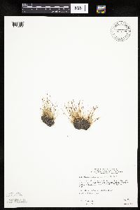 Eleocharis acicularis (Leiberg, J.B.) 815129[1019812]Wheeler, Gerald 105351988-05-27 United States, Minnesota, Norman, W1/2 NE1/4 Sec25 T145N R49W (Halstad Township) Ca. 1 mi W of Halstad; S of Rte 200. Near the Red River.;;145N;49W;25, 47.347671 -96.840153 |
MIN:Plants | 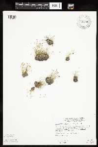 Eleocharis acicularis (Leiberg, J.B.) 815194[1019874]Wheeler, Gerald 114231988-07-26 United States, Minnesota, Big Stone, Big Stone Co.; Ca. 1.2 mi NW of Barry; about 0.3 mi E of Rte. 57; SE1/4 NW1/4 Sec.8 T124N R47W (Toqua Township);Barry Lake Wildlife Management Area;124N;47W;8, 45.565691 -96.586118 |
MIN:Plants | 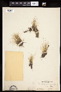 Eleocharis acicularis (Leiberg, J.B.) 81527[1019839]Skinner, S. 371902-06-06 United States, Minnesota, Jackson, Heron Lake;;N;;, 43.771287 -95.272522 |
MIN:Plants | 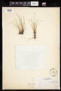 Eleocharis acicularis (Leiberg, J.B.) 81552[1019770]Rosendahl, C.; Butters, F. 36011918-07-09 United States, Minnesota, Crow Wing, 2 mi E of Fort Ripley;;N;;, 46.16607 -94.31847 |
MIN:Plants |  Eleocharis acicularis (Leiberg, J.B.) 81553[1019838]Moyer, Lycurgus 5871893-09-10 United States, Minnesota, Chippewa, Montevideo;;117N;40W;, 44.934626 -95.675774 |
MIN:Plants |  Eleocharis acicularis (Leiberg, J.B.) 81554[1102527]Ballard, C. 5871891-06-00 United States, Minnesota, Carver, Chaska;;N;;, 44.789407 -93.602179 |
MIN:Plants |  Eleocharis acicularis (Leiberg, J.B.) 81555[1019772]Burglehaus, F. 5871892-09-00 United States, Minnesota, Hennepin, Minneapolis;;N;;, 44.979965 -93.263836 |
MIN:Plants |  Eleocharis acicularis (Leiberg, J.B.) 81559[1019771]Johnson, A.; Rosendahl, C. s.n.1917-09-00 United States, Minnesota, Anoka, Moore Lake.;;030N;24W;, 45.080985 -93.255535 |
MIN:Plants |  Eleocharis acicularis (Leiberg, J.B.) 81558[1019773]Rosendahl, C.; Butters, F. 28711915-06-11 United States, Minnesota, Anoka, Moore Lake, S Anoka Co.;;030N;24W;, 45.080985 -93.255535 |
MIN:Plants |  Eleocharis acicularis (Leiberg, J.B.) 81560[1019799]Rosendahl, C. 34061916-09-18 United States, Minnesota, Ramsey, Along Larpentuer Ave, W of the [UM] College of Agriculture.;;029N;23W;, 44.992077 -93.166387 |
MIN:Plants |  Eleocharis acicularis (Leiberg, J.B.) 81561[1019903]Rosendahl, C.; Butters, F. 35871918-07-08 United States, Minnesota, Mille Lacs, Mille Lacs;;N;;, 45.910893 -93.63 |
MIN:Plants |  Eleocharis acicularis (Leiberg, J.B.) 81563[1102533]Oestlund, O. s.n.1884-06-19 United States, Minnesota, Ramsey, Ramsey Co.;;;;, 45.02 -93.1 |
MIN:Plants |  Eleocharis acicularis (Leiberg, J.B.) 81564[1019754]Sandberg, John s.n.1884-08-00 United States, Minnesota, Goodhue, Red Wing;;113N;14W;, 44.555216 -92.495543 |
MIN:Plants |  Eleocharis acicularis (Leiberg, J.B.) 81565[1102530]Sandberg, John s.n.1886-06-00 United States, Minnesota, Chisago, [no further data];;;;, 45.522134 -92.91 |
MIN:Plants |  Eleocharis acicularis (Leiberg, J.B.) 81566[1102529]Leiberg, John s.n.1883-00-00 United States, Minnesota, Blue Earth, [no further data];;;;, 44.05764 -94.101199 |
MIN:Plants |  Eleocharis acicularis (Leiberg, J.B.) 81568[1019855]Sheldon, Edmund S8171891-07-00 United States, Minnesota, Brown, Sleepy Eye;;N;;, 44.325885 -94.684758 |
MIN:Plants |  Eleocharis acicularis (Leiberg, J.B.) 81569[1019887]Ballard, C. B2811891-06-00 United States, Minnesota, Scott, Jordan;;114N;23W;, 44.674435 -93.582701 |
MIN:Plants |  Eleocharis acicularis (Leiberg, J.B.) 81570[1019758]MacMillan, C.; et al. 141Sk1900-08-00 United States, Minnesota, Polk, Maple Lake;;148N;43W;, 47.629357 -96.131143 |
MIN:Plants |  Eleocharis acicularis (Leiberg, J.B.) 81571[1019801]Ballard, C. 26151900-08-00 United States, Minnesota, Kittson, Humboldt.;;163N;50W;, 48.93381 -97.128306 |
MIN:Plants |  Eleocharis acicularis (Leiberg, J.B.) 81572[1019837]Ballard, C. B7901891-07-30 United States, Minnesota, Swan Lake.;;;;, 45.3167 -93.2667 |
MIN:Plants |  Eleocharis acicularis (Leiberg, J.B.) 81573[1019757]Arthur, J.; et al. B1501886-07-22 United States, Minnesota, Saint Louis, Vermilion Lake;;;;, 47.879148 -92.351718 |
MIN:Plants |  Eleocharis acicularis (Leiberg, J.B.) 81574[1019804]Sheldon, Edmund S37941892-08-00 United States, Minnesota, Otter Tail, Sand Lake;;137N;43W;36, 46.637443 -96.056558 |
MIN:Plants |  Eleocharis acicularis (Leiberg, J.B.) 81575[1019760]MacMillan, C.; et al. M&S521890-08-00 United States, Minnesota, Crow Wing, Brainerd;;133N;28W;03, 46.34845 -94.24059 |
MIN:Plants |  Eleocharis acicularis (Leiberg, J.B.) 81576[1019755]Taylor, B. T741891-06-00 United States, Minnesota, Le Sueur, Elysian;;109N;24W;, 44.239498 -93.707142 |
MIN:Plants |  Eleocharis acicularis (Leiberg, J.B.) 81577[1019901]Ballard, C. B791900-06-11 United States, Minnesota, Carver, Chaska;;116N;23W;34, 44.812043 -93.571507 |
MIN:Plants | 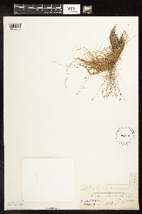 Eleocharis acicularis (Leiberg, J.B.) 81578[1102545]S., J. s.n. United States, Minnesota, Blue Earth, [no further data];;;;, 44.05764 -94.101199 |
MIN:Plants |  Eleocharis acicularis (Leiberg, J.B.) 81579[1019768]Rosendahl, C.; et al. 40181921-06-17 United States, Minnesota, Yellow Medicine, Granite Falls.;;;;, 44.809958 -95.545575 |
MIN:Plants |  Eleocharis acicularis (Leiberg, J.B.) 81580[1019886]Sheldon, Edmund S1611891-06-00 United States, Minnesota, Blue Earth, Madison Lake;;N;;, 44.204412 -93.815508 |
MIN:Plants |  Eleocharis acicularis (Leiberg, J.B.) 81581[1102532]Sandberg, John s.n.1886-06-00 United States, Minnesota, Chisago, [no further data];;;;, 45.522134 -92.91 |
MIN:Plants | 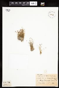 Eleocharis acicularis (Leiberg, J.B.) 81582[1019902]Sheldon, Edmund S36471892-08-00 United States, Minnesota, Otter Tail, Fergus Falls;;N;;, 46.283015 -96.077558 |
MIN:Plants | 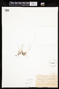 Eleocharis acicularis (Leiberg, J.B.) 81583[1019756]Sheldon, Edmund S24161892-06-00 United States, Minnesota, Aitkin, Nichols;;044N;27W;04, 46.32387 -93.75721 |
MIN:Plants | 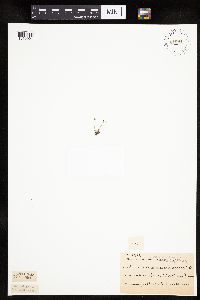 Eleocharis acicularis (Leiberg, J.B.) 81584[1019904]Sheldon, Edmund S33881892-08-00 United States, Minnesota, Otter Tail, Silver Lake.;;N;;, 46.698868 -95.659449 |
MIN:Plants | 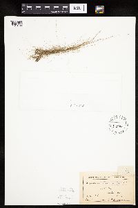 Eleocharis acicularis (Leiberg, J.B.) 81585[1019798]Anderson, A. An7791893-08-00 United States, Minnesota, Goodhue, Burnside;;N;;, 44.580189 -92.618293 |
MIN:Plants |  Eleocharis acicularis (Leiberg, J.B.) 81586[1019853]Sheldon, Edmund s.n.1894-09-00 United States, Minnesota, Hennepin, Meeker Island, on Mississippi R near Milwaukee bridge;;N;;, 44.92913 -93.564124 |
MIN:Plants |  Eleocharis acicularis (Leiberg, J.B.) 81587[1019878]Kassube, J. s.n.1878-06-00 United States, Minnesota, Hennepin, Minneapolis;;N;;, 44.979965 -93.263836 |
MIN:Plants |  Eleocharis acicularis (Leiberg, J.B.) 81588[1019764]Wheeler, William 5271899-08-16 United States, Minnesota, Houston, Jefferson;Dorer Memorial Hardwood State Forest;101N;04W;35, 43.50806 -91.28287 |
MIN:Plants |  Eleocharis acicularis (Leiberg, J.B.) 81589[1102534]Burglehaus, F. s.n.1891-08-00 United States, Minnesota, Hennepin, [no further data];;;;, 45 -93.47 |
MIN:Plants | 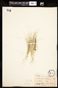 Eleocharis acicularis (Leiberg, J.B.) 81590[1019875]Frost, W. F2441892-07-00 United States, Minnesota, Kandiyohi, Willmar;;N;;, 45.121908 -95.043342 |
MIN:Plants | 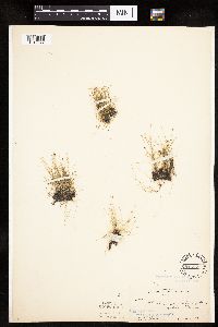 Eleocharis acicularis (Leiberg, J.B.) 81592[1019877]Ballard, C. 28511901-06-11 United States, Minnesota, Clay, Sabin;;N;;, 46.779684 -96.653133 |
MIN:Plants | 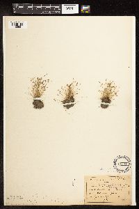 Eleocharis acicularis (Leiberg, J.B.) 81594[1102531]Sandberg, John s.n.1890-06-00 United States, Minnesota, Chisago, [no further data];;;;, 45.522134 -92.91 |
MIN:Plants | 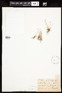 Eleocharis acicularis (Leiberg, J.B.) 81595[1019884]Taylor, B. T12161892-06-00 United States, Minnesota, Chisago, Center City;;N;;, 45.42608 -92.83619 |
MIN:Plants | 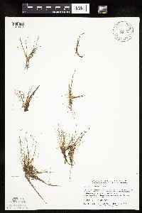 Eleocharis acicularis (Leiberg, J.B.) 817136[1019873]Delaney, B. 892991989-08-25 United States, Minnesota, Isanti, Lakeshore, small bog lake 2 mi NE of the crossroads known as Springvale, at the Springvale Campground; NW1/4 NE1/4 Sec. Lakeshore, small bog lake 2 mi NE of the crossroads known as Springvale, at the Springvale Campground; NW1/4 NE1/4 Sec. 1 T36N R24W. 036N 24W 1, 45.637606 -93.275955 |
MIN:Plants |  Eleocharis acicularis (Leiberg, J.B.) 81556[1019766]Rosendahl, C. s.n.1917-10-07 United States, Minnesota, Ramsey, St. Anthony Park [neighborhood near U of M], St. Paul.;;028N;23W;, 44.992077 -93.166387 |
MIN:Plants |  Eleocharis acicularis (Leiberg, J.B.) 828190[1019745]Dana, R. s.n.1990-07-02 United States, Minnesota, Kittson, Kittson Co.; SE1/4 SW1/4 Sec.1 T159N R46W;;159N;46W;1, 48.618 -96.5289993 |
MIN:Plants |  Eleocharis acicularis (Leiberg, J.B.) 832197[1019797]Benson, Robert 1041941-08-14 United States, Minnesota, Scott, Scott Co. Minn. R. bottoms - Savage. T115 R21 S9;;115N;21W;9, 44.780948 -93.353693 |
MIN:Plants |  Eleocharis acicularis (Leiberg, J.B.) 832198[1019881]Benson, Robert 1251941-08-19 United States, Minnesota, Kandiyohi, Kandiyohi Co. State Game Refuge T121 R33 [prob. Dietrich Lange Wildlife Management Area];Dietrich Lange Wildlife Management Area;121N;33W;, 45.282569 -94.824825 |
MIN:Plants |  Eleocharis acicularis (Leiberg, J.B.) 833644[1019810]Smith, Welby 142811988-06-20 United States, Minnesota, Washington, Washington Co. At the S end of Oneka Lake, about 2 mi NE Hugo. SW1/4 SE1/4 sec 9, T31N R21W;;031N;21W;9, 45.1833344 -92.9694443 |
MIN:Plants |  Eleocharis acicularis (Leiberg, J.B.) 833816[1019832]Smith, Welby 142101988-06-19 United States, Minnesota, Washington, Washington Co. About 2.5 mi E-NE of Scandia. NE1/4 SE1/4 sec 7, T32N R19W;;032N;19W;7, 45.273759 -92.765475 |
MIN:Plants |  Eleocharis acicularis (Leiberg, J.B.) 834001[1019788]Smith, Welby 200491991-08-24 United States, Minnesota, Lake, Superior National Forest. Lake County...In the Superior National Forest, about 4.5 mi NW of Isabella. Fish Fry Lake (ponds); T 60N R 9W SW1/4 of SW1/4 of Sec 26. 060N 09W 26, 47.6491661 -91.441391 |
MIN:Plants | 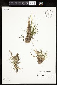 Eleocharis acicularis (Leiberg, J.B.) 834068[1019787]Smith, Welby 201041991-08-30 United States, Minnesota, Cook, Cook Co. About 9 mi N of Hovland; Swamp River. T64N R4E SW1/4 of SW1/4 of Sec.33;Grand Portage State Forest;064N;04E;33, 47.9752769 -89.952774 |
MIN:Plants | 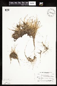 Eleocharis acicularis (Leiberg, J.B.) 837332[1019744]Smith, Welby 173741990-07-18 United States, Minnesota, Morrison, Camp Ripley Military Reservation. Camp Ripley Military Reservation Morrison Co. On the E side of Luzon Road. UTM: 389600E 5108500N T131N R30W NW1/4 of NW1 Camp Ripley Military Reservation Morrison Co. On the E side of Luzon Road. UTM: 389600E 5108500N T131N R30W NW1/4 of NW1/4 of Sec 35. 131N 30W 35, 46.114708 -94.42168 |
MIN:Plants |  Eleocharis acicularis (Leiberg, J.B.) 838335[1019789]Smith, Welby 177531990-08-07 United States, Minnesota, Red Lake, Red Lake County ... At 'Old Crossing Treaty State Wayside Park'. On the N bank of the Red Lake River, about 6 miles W of the town of Red Lake Falls ... T151N R45W SE1/4 of SW1/4 of Sec. 27. 151N 45W 27, 47.8666649 -96.4113922 |
MIN:Plants |  Eleocharis acicularis (Leiberg, J.B.) 841295[1019829]Smith, Welby 145201988-07-12 United States, Minnesota, Washington, Washington Co. At the N end of Big Marine Lake, about 5 mi NW of Marine on St. Croix; NW1/4 SE1/4 sec.20, T32N R20W;;032N;20W;20, 45.2425003 -92.8611145 |
MIN:Plants | 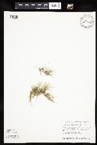 Eleocharis acicularis (Leiberg, J.B.) 841692[1019826]Smith, Welby 145421988-07-20 United States, Minnesota, Washington, Washington Co. At the SW end of Lake Elmo, about 1 mi S of the town of Lake Elmo; NW1/4 NE1/4 sec.26, T29N R21W;Lake Elmo County Park;029N;21W;25, 44.9833336 -92.8874969 |
MIN:Plants | 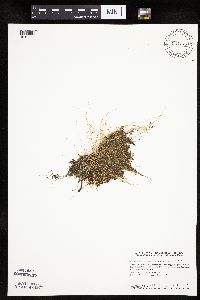 Eleocharis acicularis (Leiberg, J.B.) 841776[1019830]Smith, Welby 137201987-08-04 United States, Minnesota, Washington, Washington Co. About 7 mi W of Marine on St. Croix; NW1/4 SE1/4 sec.11, T31N R21W;;031N;21W;11, 45.1877785 -92.9208298 |
MIN:Plants | 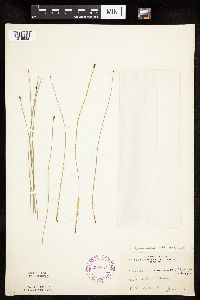 Eleocharis compressa Sullivant 265694[1019932]Ballard, C. B28521901-06-11 United States, Minnesota, Clay, Sabin.;;138N;47W;, 46.761139 -96.610232 |
MIN:Plants | 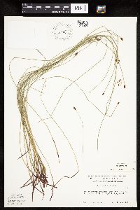 Eleocharis compressa Sullivant 270793[1019953]Delaney, B. 1985-07-11 United States, Minnesota, Anoka, Anoka Co. Cedar Creek Natural History Area. SW1/4 SE1/4 sec.35;Cedar Creek National History Area;034N;23W;35, 45.392318 -93.172984 |
MIN:Plants |  Eleocharis compressa Sullivant 362545[1019934]Rosendahl, C.; et al. 70561938-09-04 United States, Minnesota, Marshall, 2 mi. S of Holt.;;;;, 48.26297 -96.192531 |
MIN:Plants |  Eleocharis compressa Sullivant 366486[1019942]Rosendahl, C.; et al. 72741939-07-21 United States, Minnesota, Freeborn, Between U.S. 16 & Milwaukee R.R. right-of-way, 10 mi E of Albert Lea, Freeborn Co.;;;;, 43.647838 -93.168088 |
MIN:Plants |  Eleocharis compressa Sullivant 366494[1019933]Butters, F.; et al. 72401939-07-20 United States, Minnesota, Freeborn, Along the Minnesota-Iowa border, E of Emmons.;;;;, 43.54296 -93.468448 |
MIN:Plants |  Eleocharis compressa Sullivant 370734[1019950]Rosendahl, C.; Moore, John 133081940-06-27 United States, Minnesota, McLeod, On the N side of the Chicago, Milwaukee and St. Paul Railroad tracks, 1 mi. W of Sumter.;;115N;29W;, 44.761269 -94.314984 |
MIN:Plants | 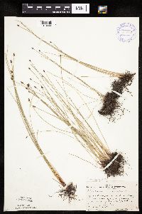 Eleocharis compressa Sullivant 370740[1019939]Rosendahl, C. 133141940-06-27 United States, Minnesota, McLeod, 4 mi. W of Brownton.;;N;;, 44.731878 -94.431801 |
MIN:Plants |  Eleocharis compressa Sullivant 370741[1019958]Rosendahl, C.; Moore, John 133151940-06-27 United States, Minnesota, McLeod, 4 mi. W of Brownton.;;N;;, 44.731878 -94.431801 |
MIN:Plants |  Eleocharis compressa Sullivant 391776[1019956]Lakela, Olga 61031945-07-15 United States, Minnesota, Saint Louis, Woodland Ave. at Elizabeth St, Duluth.;;N;;, 46.81945 -92.07519 |
MIN:Plants |  Eleocharis compressa Sullivant 393417[1019957]Lakela, Olga 70871947-07-31 United States, Minnesota, Saint Louis, Hwy. 53, ca. 1 mi. N of Cotton.;;N;;, 47.183855 -92.4763 |
MIN:Plants |  Eleocharis compressa Sullivant 437061[1019952]Moore, John; Hall, Robert 162731944-06-07 United States, Minnesota, Martin, 1 mi. W of Fairmont.;;N;;, 43.652176 -94.481102 |
MIN:Plants |  Eleocharis compressa var. acutisquamata (Buckley) S.G. Smith 437284[1019955]Moore, John; Hall, Robert 165111944-06-12 United States, Minnesota, Murray, 1-1/2 miles south-east of Slayton on Highway 59.;;106N;41W;, 43.978604 -95.76348 |
MIN:Plants |  Eleocharis compressa var. acutisquamata (Buckley) S.G. Smith 437302[1020008]Moore, John; Hall, Robert 165891944-06-14 United States, Minnesota, Renville, Renville County ... near bridge; Highway 19 at Morton.;;113N;34W;, 44.585501 -94.934085 |
MIN:Plants |  Eleocharis compressa var. compressa Sullivant 441044[1020018]Puchalski, L. 2701993-07-08 United States, Minnesota, Mahnomen, Mahnomen County...in a small prairie remnant about 50-75 yds west of Hwy 59...T 146N R 42W SE1/4 of NE1/4 of Sec 3;Nelson Prairie / White Earth Indian Reservation;146N;42W;03, 47.491995 -95.986889 |
MIN:Plants |  Eleocharis compressa var. compressa Sullivant 448481[1020020]Hall, Robert 164011944-06-10 United States, Minnesota, Pipestone, Pipestone County ... 1/2 mile north of Pipestone.;;106N;46W;, 43.979723 -96.367859 |
MIN:Plants |  Eleocharis compressa Sullivant 458794[1019993]Puchalski, L. 4441993-09-07 United States, Minnesota, Polk, Polk Co.; in undulating terrain just N of Lake Agassiz beach ridge; T149N R43W NE1/4 of NE1/4 of Sec 8;;149N;43W;8, 47.737766 -96.191481 |
MIN:Plants |  Eleocharis compressa var. acutisquamata (Buckley) S.G. Smith 460866[1020003]Smith, Welby 148231988-08-09 United States, Minnesota, Pipestone, Burke Wildlife Management Area. Pipestone County ... Burke State Wildlife Management Area, about 3 miles east of Hatfield ... SE1/4 SE1/4 sec.28, T 106N R 44W. 106N 44W 28, 43.9522209 -96.1275024 |
MIN:Plants |  Eleocharis compressa Sullivant 464394[1019983]Smith, Michael 4961997-08-11 United States, Minnesota, Koochiching, East Rat Root River Peatland Scientific Natural Area. Voyageurs National Park. Koochiching Co.; Plot name: Voya 91, DNR #7280; Location: Rat Root Peatland, Voyageurs National Park. Koochiching Co.; Plot name: Voya 91, DNR #7280; Location: Rat Root Peatland, [this locale not in the national park]. 069N 22W , 48.4919434 -93.1636124 |
MIN:Plants |  Eleocharis compressa var. acutisquamata (Buckley) S.G. Smith 475918[1020004]Smith, Welby 210161992-07-20 United States, Minnesota, Redwood, Redwood County...Minnesota River Valley, about 3 miles northeast of Belview...T 114N R 37W NE1/4 of NW1/4 of Sec 27 Sec 27. 114N 37W 27, 44.6563873 -95.2977753 |
MIN:Plants |  Eleocharis compressa Sullivant 507194[1019940]Moore, John 206421950-06-20 United States, Minnesota, Martin, 1/2 mi. W of Fairmont.;;N;;, 43.652176 -94.481102 |
MIN:Plants |  Eleocharis compressa var. compressa Sullivant 515698[1020014]Schik, K. 96-1111996-06-25 United States, Minnesota, Wilkin, Wilkin Co. T135N R46W SW1/4 of the NW1/4 of S12...at Western Prairie South Nature Conservancy Preserve.;Western Prairie South Scientific Natural Area;135N;46W;12, 46.521816 -96.414416 |
MIN:Plants |  Eleocharis compressa Sullivant 564885[1019947]Cotter Tucker, Shirley 41311957-06-19 United States, Minnesota, Polk, Along the Great Northern right-of-way near the Northwest School of Agriculture, Crookston.;;N;;, 47.774138 -96.608121 |
MIN:Plants |  Eleocharis compressa Sullivant 564956[1019949]Cotter, Shirley 18751951-06-09 United States, Minnesota, Renville, Renville Co.; between Hwy. 212 and the railroad, 3 mi. W of Hector.;;115N;323;, 44.743834 -94.776716 |
MIN:Plants |  Eleocharis compressa Sullivant 565117[1019938]Cotter Tucker, Shirley 40791957-06-10 United States, Minnesota, Polk, Near the Northwest School of Agriculture, Crookston.;;N;;, 47.774138 -96.608121 |
MIN:Plants |  Eleocharis compressa Sullivant 584513[1019961]Ownbey, Gerald 35401963-07-09 United States, Minnesota, Clearwater, 5.6 mi. N of Clearbrook. T150N R37W SE1/4 Sec 30.;;150N;37W;30, 47.782628 -95.441271 |
MIN:Plants |  Eleocharis compressa Sullivant 585659[1019951]Moore, John 260631963-06-27 United States, Minnesota, Kittson, 4 mi. W of Karlstad.;;N;;, 48.577443 -96.608094 |
MIN:Plants |  Eleocharis compressa Sullivant 590407[1019948]Ownbey, Gerald 38421965-08-18 United States, Minnesota, Polk, Malberg Prairie, 2 mi. W, 2.5 mi. N of Eldred. T149N R48W W1/2 NW1/4 Sec 16;Malmberg Prairie Scientific Natural Area;149N;48W;16, 47.72417 -96.813965 |
MIN:Plants |  Eleocharis compressa Sullivant 619133[1019937]Westkaemper, Remberta s.n.1969-06-00 United States, Minnesota, Stearns, Stearns Co. St. Joseph.;;124N;29W;, 45.543642 -94.322053 |
MIN:Plants |  Eleocharis compressa Sullivant 670121[1019936]Westkaemper, Remberta s.n.1970-07-00 United States, Minnesota, Stearns, Stearns Co. St. Joseph.;;124N;29W;, 45.543642 -94.322053 |
MIN:Plants |  Eleocharis compressa Sullivant 670160[1019935]Westkaemper, Remberta s.n.1974-08-00 United States, Minnesota, Stearns, Stearns Co. St. Joseph.;;124N;29W;, 45.543642 -94.322053 |
MIN:Plants | 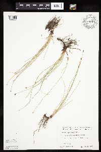 Eleocharis compressa Sullivant 693950[1019967]Roefer, Florence s.n.1978-06-11 United States, Minnesota, Cottonwood, Jeffers Petroglyph Historic Site. T107N R35W NW1/4 Sec.9;Jeffers Petroglyphs Historical Site;107N;35W;9, 44.086452 -95.049966 |
MIN:Plants | 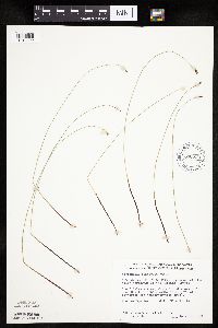 Eleocharis compressa Sullivant 698224[1019992]Wheeler, Gerald; Glaser, Paul 30241978-06-22 United States, Minnesota, Beltrami, Ca. 13.5 mi. NW of Waskish. Ovoid Islands Area; ca. 0.5 mi. W of Camp No. 1. Site 24. NE1/4 SW1/4 Sec.25 T156N R32W.;;156N;32W;25, 48.303133 -94.695865 |
MIN:Plants | 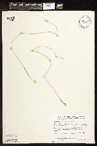 Eleocharis compressa Sullivant 698501[1102561]Wheeler, Gerald; Glaser, Paul 33051978-07-17 United States, Minnesota, Beltrami, Ca. 25 mi. NW of the Waskish Airport. Western Water Track. Site 75.;Beltrami Island State Forest / Red Lake Wildlife Management Area;155N;34W;4, 48.273655 -95.021912 |
MIN:Plants | 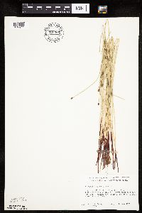 Eleocharis compressa Sullivant 700569[1019944]Ownbey, Gerald 58561978-06-14 United States, Minnesota, Clearwater, 1.7 mi. NW of the jct. of Rte. 92 and 5 in Clearbrook, on Rte. 92.;;N;;, 47.709985 -95.463117 |
MIN:Plants |  Eleocharis compressa Sullivant 700627[1019988]Ownbey, Gerald 59711978-06-21 United States, Minnesota, Beltrami, Rte. 89, 1.8 mi. SE of its jct. with Rte. 44 at Fourtown. W side of the roadway. T155N R36W SW1/4 Sec. 5.;;155N;36W;5, 48.273478 -95.303515 |
MIN:Plants |  Eleocharis compressa Sullivant 722301[1019987]Wheeler, Gerald 53351980-08-10 United States, Minnesota, Anoka, Anoka County...Ham Lake...eadow adjacent to the lake on the S side. T32N R23W Sec.21;;032N;23W;21, 45.247884 -93.214062 |
MIN:Plants |  Eleocharis compressa Sullivant 730501[1019969]Cross-Cella, J. 1371980-06-16 United States, Minnesota, Wilkin, Western Prairie North: 8 mi. N of Rothsay. SW1/4 SE1/4 Sec 17 T139N R45W;Western Prairie North, The Nature Conservancy;139N;45W;17, 46.594689 -96.376132 |
MIN:Plants |  Eleocharis compressa Sullivant 730917[1019960]Cross-Cella, J. 091980-06-02 United States, Minnesota, Clay, Audubon Prairie: 16.5 mi. E-SE of Moorhead. SW1/4 Sec 22, T139N R45W;Audubon Prairie, The Nature Conservancy;139N;45W;22, 46.840678 -96.354951 |
MIN:Plants | 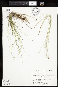 Eleocharis compressa Sullivant 730932[1019982]Cross-Cella, J. 2261980-07-08 United States, Minnesota, Clay, Audubon Prairie: 16.5 mi. E-SE of Moorhead. NE1/4 SE1/4 Sec.31 T139N R45W;Audubon Prairie, The Nature Conservancy;139N;45W;31, 46.811065 -96.414695 |
MIN:Plants | 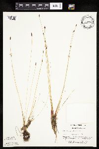 Eleocharis compressa Sullivant 744720[1019968]Converse, C. 9811982-06-03 United States, Minnesota, Pope, Moe Woods. SE1/4 SW1/4 Sec.34 T123N R36W;Moe Woods, The Nature Conservancy;123N;36W;34, 45.41981 -95.183338 |
MIN:Plants |  Eleocharis compressa Sullivant 744740[1019946]Converse, C. 14641982-07-06 United States, Minnesota, Otter Tail, Otter Tail Preserve. T131N R44W E1/2 of Sec 17;Ottertail Prairie Scientific Natural Area;131N;44W;17, 46.159244 -96.235363 |
MIN:Plants |  Eleocharis compressa Sullivant 745966[1019984]Smith, Welby 46571981-07-02 United States, Minnesota, Clay, Ca. 3 mi. E-SE of the jct. of Hwy. 9 and Hwy. 34 in Felton. NE1/4 SE1/4 Sec.36 T142N R46W.;;142N;46W;36, 47.071261 -96.447104 |
MIN:Plants | 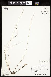 Eleocharis compressa var. acutisquamata (Buckley) S.G. Smith 745985[1020000]Smith, Welby 53891981-08-11 United States, Minnesota, Carlton, Carlton County ... About 2-1/2 miles south of Wright ... Section 22 T 48N R 21W.;;048N;21W;22, 46.629293 -92.989598 |
MIN:Plants |  Eleocharis compressa Sullivant 746179[1102560]Smith, Welby 51511981-07-31 United States, Minnesota, Norman, On the E side of Hwy. 40, ca. 2 1/2 mi. S of Faith. SW1/4 NW1/4 sec.25 T144N R43W.;;144N;43W;25, 47.260368 -96.077573 |
MIN:Plants | 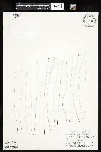 Eleocharis compressa Sullivant 746248[1019986]Smith, Welby 53161981-08-06 United States, Minnesota, Jackson, Ca. 6 1/2 mi. NE of Lakefield. On a NE-facing bluff in the Des Moines River Valley. NE1/4 NE1/4 sec.7 T103N R35W.;;103N;35W;7, 43.739341 -95.084917 |
Google Map
Google Maps is a web mapping service provided by Google that features a map that users can pan (by dragging the mouse) and zoom (by using the mouse wheel). Collection points are displayed as colored markers that when clicked on, displays the full information for that collection. When multiple species are queried (separated by semi-colons), different colored markers denote each individual species.