University of Minnesota
http://www.umn.edu/
612-625-5000
http://www.umn.edu/
612-625-5000
Minnesota Biodiversity Atlas
Bell Museum
Dataset: MIN-Plants
Taxa: Myrsinaceae
Search Criteria: excluding cultivated/captive occurrences
Bell Museum plants | |
 MIN:Plants |  449928[1188809]Soper, J. H. 3912 Canada, Ontario, Northumberland |
MIN:Plants |  594983[1188810]Baldwin, W. K. W. 9178 Canada, Ontario, Kenora |
MIN:Plants |  170388[1188811]Brown, H. E. 640 United States, California, Siskiyou |
MIN:Plants |  522907[1188812]Cooper, W. S. s.n. United States, Michigan, Oakland |
MIN:Plants | 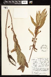 541047[1188813]Iltis, H. H. 922 United States, Wisconsin, Chippewa |
MIN:Plants | 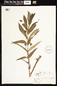 573819[1188814]Stevens, O. A. 2400 United States, North Dakota, Bottineau |
MIN:Plants | 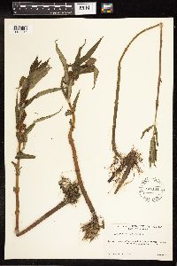 546141[1188815]Scoggan, H. J. 2798 Canada, Manitoba |
MIN:Plants | 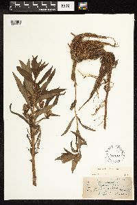 365523[1188816]Cotter, R. V. s.n. United States, Utah, Cache |
MIN:Plants |  170386[1188817]Umbach, L.M. s.n. United States, Indiana, Lake, Miller's |
MIN:Plants |  170385[1188818]Nelson, N. L. T. s.n. United States, Illinois, Cook |
MIN:Plants |  569449[1188819]Thieret, J. W. 7238 Canada, Northwest Territories |
MIN:Plants |  154515[1188746]Fernald, M. L. s.n. United States, Maine, Aroostook |
MIN:Plants |  947999[1188749]Sandberg, J. H. 250 United States, Washington, Okanogan |
MIN:Plants |  947989[1188755]Fink, B. s.n. United States, Iowa, Fayette |
MIN:Plants |  963115[1346816]Whitfeld, T.J.S. 22522019-06-23 United States, Minnesota, Itasca, Us Army Corps of Engineers Winnibigoshish Recreation Area, point, 47.43237 -94.052647 |
MIN:Plants |  963124[1346806]Whitfeld, T.J.S. 24732019-06-22 United States, Minnesota, Cass, US Army Corps of Engineers Winnibigoshish Recreation Area, dam-roadside, 47.429813 -94.049797 |
MIN:Plants |  0963200[1348071]Stork, H. E. s. n.1925-00-00 United States, Minnesota, Itasca, Bowstring, 47.543003 -93.796597 |
MIN:Plants |  0963201[1348072]KenKnight, Glenn s. n.1952-00-00 United States, Minnesota, Clearwater |
MIN:Plants |  0963202[1348073] s. n.1885-05-00 United States, Minnesota, Minnetonka Lake, 44.788694 -93.342167 |
MIN:Plants |  0963203[1348074]Stork, H. E. s. n.1925-00-00 United States, Minnesota, Itasca, Bowstring, 47.543003 -93.796597 |
MIN:Plants |  0963204[1348075]Stork, H. E. s. n.1925-00-00 United States, Minnesota, Itasca, Bowstring, 47.543003 -93.796597 |
MIN:Plants |  0963216[1348087] United States, Wisconsin |
MIN:Plants |  0963217[1348088] United States, Wisconsin |
MIN:Plants |  0963218[1348089] United States, Wisconsin |
MIN:Plants |  0963219[1348090] United States, Wisconsin |
MIN:Plants |  0963220[1348091] United States, Wisconsin |
MIN:Plants |  0963221[1348092] United States, Wisconsin |
MIN:Plants | MPCA_Dummy53[]Michael Bourdaghs 2021-06-22 United States, Minnesota, Aitkin, Collected as part of the US Environmental Protection Agency National Wetland Condition Assessment (EPA siteID NWC21-MN-10029) and MN Pollution Control Agency MN Wetland Condition Assessment (MPCA siteID 21AITK029), 46.86336304 -93.28492202 |
MIN:Plants |  969812[1371400]J. Vigness-Pint 232003-07-03 United states, Minnesota, Ramsey, Drainage Area: BL-113, 44.988146 -92.999849 |
MIN:Plants | []Bourdaghs, Michael 2022-09-08 United States, Minnesota, Isanti, Site ID: 16ISAN299; Visit Number: 2717, 45.70582788 -93.18432639 |
MIN:Plants |  974460[1396824]Smith, Welby R WRS364082019-08-06 United States, Minnesota, Anoka, Carlos Avery State Wildlife Management Area, about 11.2 km (7 miles) southwest of the approximate center of Stacy at a heading of 225 degrees., 45.32775 -93.089 |
MIN:Plants |  974647[1396977]Smith, Welby R WRS364392019-08-07 United States, Minnesota, McLeod, Stahls Lake County Park. About 7.5 km (4.7 miles) northwest of the approximate center of Hutchinson at a heading of 324 degrees., 44.949016 -94.426506 |
MIN:Plants | []Timothy J. S. Whitfeld 36082023-07-06 United States, Minnesota, Marshall, Agassiz National Wildlife Refuge, Agassiz Wilderness Area, south of Whiskey Lake, 4.8 miles north of main administration building, 48.3708 -95.9656, 346m |
MIN:Plants | []Timothy J. S. Whitfeld 36582023-07-07 United States, Minnesota, Marshall, New Maine Wildlife Management Area, 0.3 miles north northeast of intersection of 390th St NW and Center Ave N., 48.4464 -96.2803, 341m |
MIN:Plants |  976389[1403119]Dunevitz, Hannah L. 7711992-06-19 United States, Minnesota, Winona, In the Whitewater Wildlife Management Area. 5 miles northeast of St. Charles, in a wetland in an isolated 3/4 acre bowl-shaped depression on a broad mid-bluff terrace along the South Fork Whitewater River., 44.01 -91.97 |
MIN:Plants |  909956[1144056]Gerdes, Lynden 56672008-08-20 United States, Minnesota, Lake, Boundary Waters Canoe Area Wilderness / Superior National Forest. T65N R11W S02NESW. Lake County, MN. Superior National Forest. Boundary Waters Canoe Area Wilderness. Crooked Lake; approximately 0.43 miles east of Circle Lake.. 065N 11W 2, 48.1437784 -91.7064878 |
MIN:Plants |  509314[1144102]Roitsch, C. 5402000-07-31 United States, Minnesota, Morrison, [no further data];Crane Meadows National Wildlife Refuge;;;, 45.9667 -94.3667 |
MIN:Plants |  452961[1144101]Wheeler, Gerald 202421999-08-03 United States, Minnesota, Le Sueur, Le Sueur Co.; Ca. 2 mi. NE of St. Peter on Rte. 23; N1/2 SW1/4 Sec. 14 T110N R26W;;110N;26W;14, 44.3338469 -93.9190813 |
MIN:Plants |  913553[1144012]Smith, Welby 254781994-09-08 United States, Minnesota, Beltrami, Beltrami County... At the Waskish Municipal Campground...T154N R30W SE1/4 of NE1/4 of Sec8;;154N;30W;08, 48.1722222 -94.5116667 |
MIN:Plants |  297457[1188913]Benner, F.; et al. 1401928-08-01 United States, Wisconsin, Polk, 5 mi. N. St. Croix Falls, Wis. on river Road;Saint Croix National Riverway;;;, 45.470949 -92.681073 |
MIN:Plants |  335540[1188914]Lakela, Olga s.n.1936-08-13 United States, Wisconsin, Douglas, about 2 mi. out [=west of?]. Superior. |
MIN:Plants |  427605[1144241]Cholewa, A. 25892006-07-11 United States, Minnesota, Ramsey, along the Mississippi River, across from the international airport; along trail on the north side of Upper Lake.;Hidden Falls - Crosby Farm Regional Park;028N;23W;22, 44.900733 -93.158601 |
MIN:Plants |  898022[1144195]Scott, P. 17842004-07-23 United States, Minnesota, Lake, Lake Co. ... by pond near SE corner of Hwy 1 and Tomahawk Tr.;Superior National Forest;061N;10W;31, 47.7260881 -91.6518509 |
MIN:Plants |  170847[1144239]Taylor, B. T.14261892-07-00 United States, Minnesota, Chisago, [no further data];;;;, 45.506109 -92.911575 |
MIN:Plants |  435182[1144100]Boe, J. 970718021997-07-18 United States, Minnesota, Aitkin, Aitkin Co.; pinery east of Prairie River Flowage in Savanna Portage State Park; T 49N R 23W NW1/4 of NW1/4 of sec 2;Savanna Portage State Park;049N;23W;2, 46.7597155 -93.2232713 |
MIN:Plants |  170854[1144230]Skinner, S. 2931902-00-00 United States, Minnesota, Murray, near Lake Shetek. Heron Lake Region.;;108N;40W;00, 44.1521528 -95.6427962 |
MIN:Plants |  911748[1144151]Cholewa, A. 26812009-08-07 United States, Minnesota, Anoka, Anoka County, Linwood Lake County Park, along road leading to public boat ramp at northeast end of lake. T33N R22W Sec 9;Martin-Island-Linwood Lakes County Park;033N;22W;09, 45.3627837 -93.0915675 |
MIN:Plants |  681590[1188911]Swanson, Steven 16411975-07-21 United States, Wisconsin, La Crosse, Mississippi River, (Navigation Pool #8)...La Crosse Co, Site 40, old spit;Upper Mississippi National Wildlife Refuge |
MIN:Plants | 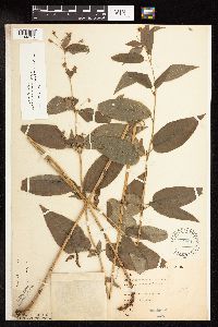 170815[1144115]Goldsmith, G. G1511912-00-00 United States, Minnesota, Rice, Northfield;;N;;, 44.458298 -93.161604 |
MIN:Plants | 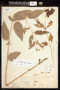 170833[1144116]Bergman, H. 31181914-08-28 United States, Minnesota, Hubbard, Quadrat 2A, Benedict;;143N;32W;35, 47.1572871 -94.6956984 |
MIN:Plants | 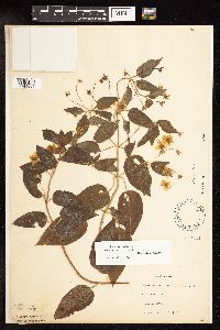 170834[1144005]G. & L. 6161885-07-00 United States, Minnesota, Chippewa, Montevideo.;;117N;40W;, 44.9346263 -95.6757744 |
MIN:Plants | 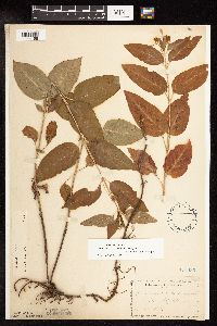 170835[1144196]Manning, Sara s.n.1892-08-20 United States, Minnesota, Wabasha, Lake City, Minn.;;N;;, 44.449412 -92.266844 |
MIN:Plants |  170836[1144023]Moyer, Lycurgus 28161906-08-03 United States, Minnesota, Pope, Pope Co.;;;;, 45.586015 -95.444479 |
MIN:Plants |  170837[1144104]Rosendahl, C. 6301902-06-26 United States, Minnesota, Houston, Spring Grove;;101N;07W;, 43.5439231 -91.6707002 |
MIN:Plants |  170839[1144047]Campbell, Jennie 1895-07-00 United States, Minnesota, Stearns, Waite Park;;124N;28W;, 45.541667 -94.2051259 |
MIN:Plants |  170840[1144119]Sandberg, John s.n.1885-07-00 United States, Minnesota, Goodhue, Red Wing;;113N;14W;, 44.5552164 -92.4955428 |
MIN:Plants |  170841[1144061]Sandberg, John 1890-07-00 United States, Minnesota, Hennepin, [no further data];;;;, 45 -93.47 |
MIN:Plants |  170842[1144227]Aiton, G. s.n.1891-07-00 United States, Minnesota, Clearwater, Lake Itasca.;Itasca State Park;143N;36W;, 47.19557 -95.2332161 |
MIN:Plants |  170843[1144105]Herrick, C. s.n.1884-07-03 United States, Minnesota, Carlton, St. Louis River [prob near WI state line];Jay Cooke State Park;048N;15W;, 46.649665 -92.330748 |
MIN:Plants |  170844[1144228]Campbell, Jennie s.n.1895-07-00 United States, Minnesota, Dakota, Minnesota River bottoms.;;N;;, 44.83699 -93.215027 |
MIN:Plants |  170845[1144064]Herrick, C. 315-41877-07-21 United States, Minnesota, Hennepin, Minneapolis;;N;;, 44.979965 -93.263836 |
MIN:Plants |  170846[1144066]Herrick, C. s.n.1876-07-00 United States, Minnesota, Hennepin, Minneapolis;;N;;, 44.979965 -93.263836 |
MIN:Plants |  170849[1144007]Ballard, C. B15781893-07-00 United States, Minnesota, Cass, Gull Lake.;;N;;, 46.431425 -94.339083 |
MIN:Plants |  170850[1144236]Menzel, Max s.n.1895-08-00 United States, Minnesota, Pipestone, Pipestone [assuming the quarry area; town generally noted as "Pipestone City" by collector];Pipestone National Monument;106N;46W;01, 44.01585 -96.31767 |
MIN:Plants |  170851[1144077]Frost, W. F2771892-07-00 United States, Minnesota, Kandiyohi, Willmar, Kandiyohi Co.;;N;;, 45.122778 -95.048611 |
MIN:Plants |  170852[1144063]Aiton, G. s.n.1896-07-00 United States, Minnesota, Hennepin, near Minneapolis;;N;;, 44.979965 -93.263836 |
MIN:Plants |  170855[1144117]Ainslie, G. 28161901-07-08 United States, Minnesota, Olmsted, Rochester;;106N;14W;, 43.97834 -92.49834 |
MIN:Plants |  170856[1144072]MacMillan, C.; et al. 16sk United States, Minnesota, Polk, Crookston;;150N;46W;30, 47.782 -96.60007 |
MIN:Plants |  170857[1144071]Ballard, C. 27761900-08-00 United States, Minnesota, Marshall, Warren;;N;;, 48.196642 -96.77284 |
MIN:Plants |  170858[1144060]Rosendahl, C. 22041909-07-03 United States, Minnesota, Ft Snelling Reservation [old regional park spanning junction of Minnesota and Mississippi rivers];;028N;23W;, 44.9051624 -93.1664625 |
MIN:Plants |  170859[1144052]Sheldon, Edmund S28851892-07-00 United States, Minnesota, Kanabec, Mora, Kanabec Co.;;039N;24W;, 45.8606833 -93.3275287 |
MIN:Plants |  170860[1144091]Ballard, C. B10571892-07-00 United States, Minnesota, Nicollet, Courtland, Nicollet Co.;;109N;29W;, 44.2393825 -94.3113763 |
MIN:Plants |  170861[1144062]Kassube, J. s.n.1878-06-00 United States, Minnesota, Hennepin, Minneapolis;;N;;, 44.979965 -93.263836 |
MIN:Plants |  170862[1144093]Sheldon, Edmund S30391892-06-00 United States, Minnesota, Mille Lacs, Milaca, Minn.;;N;;, 45.755799 -93.654408 |
MIN:Plants |  170863[1144118]Campbell, Jennie c1051896-07-00 United States, Minnesota, Stearns, Rockville;;123N;29W;, 45.4574203 -94.3224782 |
MIN:Plants |  170864[1144051]Taylor, B. T8481891-07-00 United States, Minnesota, Pope, Glenwood;;N;;, 45.650239 -95.389758 |
MIN:Plants |  170865[1144247]Sheldon, Edmund S7261891-07-00 United States, Minnesota, Brown, Sleepy Eye, Minn.;;N;;, 44.297183 -94.72415 |
MIN:Plants |  170866[1144111]Taylor, B. T14261892-07-00 United States, Minnesota, Chisago, Lent;;N;;, 45.425103 -92.96058 |
MIN:Plants |  170867[1144103]Campbell, Jennie C491896-07-04 United States, Minnesota, Stearns, St. Cloud;;N;;, 45.55811 -94.164038 |
MIN:Plants |  170868[1144113]Ballard, C. B5691891-07-00 United States, Minnesota, Scott, Prior Lake;;N;;, 44.713297 -93.422727 |
MIN:Plants |  170869[1144069]Sheldon, Edmund S30281892-07-00 United States, Minnesota, Mille Lacs, Milaca;;N;;, 45.755799 -93.654408 |
MIN:Plants |  170870[1144095]Aiton, G. s.n.1889-08-00 United States, Minnesota, Rice, Rice Co.;;N;;, 44.36571 -93.272875 |
MIN:Plants |  170871[1144065]Herrick, C. s.n.1878-07-00 United States, Minnesota, Hennepin, Minneapolis;;N;;, 44.979965 -93.263836 |
MIN:Plants |  170872[1144231]Moyer, Lycurgus s.n.1885-07-00 United States, Minnesota, Chippewa, Montevideo.;;117N;40W;, 44.9346263 -95.6757744 |
MIN:Plants |  170873[1144253]Roberts, J. s.n.1878-08-00 United States, Minnesota, Saint Louis, Duluth;;N;;, 46.783273 -92.106579 |
MIN:Plants |  170874[1144085]Arthur, J.; et al. 71A1886-07-20 United States, Minnesota, Saint Louis, Vermilion Lake;Superior National Forest;;;, 47.891581 -92.366824 |
MIN:Plants |  227844[1144194]Stevenson, J. 1311912-07-12 United States, Minnesota, Beltrami, Bemidji.;;N;;, 47.473563 -94.880277 |
MIN:Plants |  227845[1144109]Roberts, Thomas s.n.1904-07-16 United States, Minnesota, Wabasha, Brook Lodge;;N;;, 44.383856 -92.032945 |
MIN:Plants |  264400[1144029]Holzinger, John s.n.1897-07-00 United States, Minnesota, Winona, [no further data];;;;, 43.973695 -91.731232 |
MIN:Plants |  264401[1141998]Holzinger, John s.n.1897-07-00 United States, Minnesota, Winona, Winona Co.;;N;;, 43.983795 -91.738192 |
MIN:Plants |  264402[1141999]Holzinger, John s.n.1901-07-00 United States, Minnesota, Winona, Winona Co.;;N;;, 43.983795 -91.738192 |
MIN:Plants |  264403[1144028]Holzinger, John s.n.1901-07-00 United States, Minnesota, Winona, Winona Co.;;N;;, 43.983795 -91.738192 |
MIN:Plants |  264406[1144031]Holzinger, John s.n.1901-00-00 United States, Minnesota, Winona, [no further data];;;;, 43.973695 -91.731232 |
MIN:Plants |  276166[1144221]Grant, Martin 28221929-07-19 United States, Minnesota, Clearwater, Headwaters of the Mississippi River. NW-NE of section;Itasca State Park;143N;36W;02, 47.2319733 -95.201528 |
MIN:Plants |  270041[1144088]Wheeler, William 661896-07-18 United States, Minnesota, Houston, Winnebago Valley, Houston Co.;Dorer Memorial Hardwood State Forest;N;;, 43.537379 -91.40119 |
MIN:Plants |  271068[1144197]Vuke, G. 211948-07-00 United States, Minnesota, Clearwater, LaSalle Trail;Itasca State Park;143N;36W;, 47.19557 -95.2332161 |
MIN:Plants |  277333[1144238]Rosendahl, C. 56951902-07-00 United States, Minnesota, Clearwater, School of Forestry [Univ. of Minn.] grounds;Itasca State Park;143N;36W;, 47.19557 -95.2332161 |
MIN:Plants |  277971[1144059]Roberts, Thomas s.n.1889-08-02 United States, Minnesota, Hennepin, Minneapolis;;N;;, 44.979965 -93.263836 |
MIN:Plants |  281416[1144067]Roberts, Thomas s.n.1878-00-00 United States, Minnesota, Hennepin, Minneapolis;;029N;24W;25, 44.9699591 -93.2370211 |
MIN:Plants |  281417[1144068]Roberts, Thomas s.n.1878-06-00 United States, Minnesota, Hennepin, Minneapolis;;N;;, 44.979965 -93.263836 |
Google Map
Google Maps is a web mapping service provided by Google that features a map that users can pan (by dragging the mouse) and zoom (by using the mouse wheel). Collection points are displayed as colored markers that when clicked on, displays the full information for that collection. When multiple species are queried (separated by semi-colons), different colored markers denote each individual species.