University of Minnesota
http://www.umn.edu/
612-625-5000
http://www.umn.edu/
612-625-5000
Minnesota Biodiversity Atlas
Bell Museum
Dataset: MIN-Plants
Taxa: Myrsinaceae
Search Criteria: excluding cultivated/captive occurrences
Bell Museum plants | |
 MIN:Plants |  528363[1188836]Garton, C. 18581952-07-15 Canada, Ontario, Thunder Bay, North bank of Pigeon River, at International Bridge, Devon Township. |
MIN:Plants |  541989[1188832]Bennett, H. s.n.1956-06-24 United States, Indiana, Porter, Dunes Creek west of Wilson Shelter, Indiana Dunes State Park, Porter County;Indiana Dunes National Lakeshore;;;, 41.663093 -87.032128 |
MIN:Plants |  360927[1188912]Horton, E. s.n.1936-08-13 United States, Wisconsin, Douglas, Wisconsin Point...Douglas County |
MIN:Plants |  435898[1144233]Anderson, Craig 7051999-08-18 United States, Minnesota, Stevens, Stevens Co.; Mud Creek WPA; T124N R42W: NW1/4 of NE1/4 of SW1/4 of sect. 17;Mud Creek Wildlife Management Area;124N;42W;17, 45.5498179 -95.9636655 |
MIN:Plants |  448087[1144220]Abbott, Robinson s.n.1961-08-01 United States, Minnesota, Stevens, Stevens County...off rt. 9, S. just S. of Morris.;;124N;42W;02, 45.578583 -95.9020811 |
MIN:Plants | 509993[]US Nat. Arboretum staff 1381974-00-00 United States, District of Columbia, Washington |
MIN:Plants |  805617[1188835]Garton, C. 237581987-07-02 Canada, Ontario, Thunder Bay, H. 593, along Pigeon River in Stuart Location 3 km. W. of Pigeon River customs;;;;, 48.0166667 -89.6666667 |
MIN:Plants |  913794[1144032]Smith, Welby 228921993-07-14 United States, Minnesota, Sibley, Sibley County... On the north side of Indian Lake, about 4 miles west of Gaylord... T113N R29W NW1/4 of SW1/4 of Sec 21;;113N;29W;21, 44.5791667 -94.3341667 |
MIN:Plants |  362462[1188915]Horton, E. s.n.1936-08-13 United States, Wisconsin, Douglas, Wisconsin Point, Douglas County |
MIN:Plants |  544535[1188837]Bennett, H. s.n.1957-07-07 United States, Indiana, Porter, Dunes Creek west of Wilson Shelter, Indiana Dunes State Park, Porter County;Indiana Dunes National Lakeshore;;;, 41.663093 -87.032128 |
MIN:Plants |  268806[1188833]Moore, John 121924-08-00 United States, South Dakota, Brookings, Brookings;;;;, 44.31139 -96.79806 |
MIN:Plants |  575670[1188834]Garton, C. 86351961-07-06 Canada, Ontario, Rainy River, Oak Point on Rainy River, 2-1/2 mi. below Rainy River Town, Atwood Twp. |
MIN:Plants |  904370[1144055]Gerdes, Lynden 54252007-06-22 United States, Minnesota, Lake, Fish Fry Lake approximately 4.68 miles NW of Isabella NE of boat landing. SESW of section;Superior National Forest;060N;09W;26, 47.6535424 -91.4380225 |
MIN:Plants |  921165[1144033]Smith, Welby 231441993-07-28 United States, Minnesota, Grant, Berskow Wildlife Management Area. Grant County ... Berskow State Wildlife Management Area. On the northeast side of Thorstad Lake, about 5 miles east of Elbow Lake (town) ... T129N R41W NW1/4 of NW1/4 of Sec 17. 129N 41W 17, 45.9905556 -95.8716667 |
MIN:Plants |  922916[1144122]Smith, Welby 237571993-08-28 United States, Minnesota, Cottonwood, About 6 miles west of Comfrey...T 107N R 35W NW1/4 of NE1/4 of Sec 10;;107N;35W;10, 44.0916667 -95.0233333 |
MIN:Plants |  922932[1144123]Smith, Welby 239261993-09-15 United States, Minnesota, Faribault, On the south side of Interstate 90, about one mile northwest of Blue Earth. SE1/4 of SW1/4 of section;;102N;27W;06, 43.6597222 -94.1186111 |
MIN:Plants |  931545[1144015]Gerdes, Lynden B. 63252011-08-02 United States, Minnesota, Lake, Superior National Forest. Fish Fry Lakes West. Approximately 4.96 miles WNW of Isabella, MN. The SW bay/shoreline of west Fish Fry Lake. NWSWSWSW. 060N 09W 26, 47.6477778 -91.4488889 |
MIN:Plants |  937698[1144219]Gerdes, Lynden B. 66622012-08-01 United States, Minnesota, Lake, Birch Lake dam area, approximately 6.51 miles SE of Ely, MN and 0.07 miles NNW of the dam.;Superior National Forest;062N;11W;31, 47.816944 -91.785 |
MIN:Plants |  933488[1144017]Smith, Welby R. 21350A1992-08-11 United States, Minnesota, Marshall, about 5 mi W of Middle River (town), on the N side of CSAH 6. SW1/4 SW1/4 of sec.;;157N;44W;01, 48.4097222 -96.275 |
MIN:Plants |  921028[1144242]Smith, Welby R. 248941994-07-26 United States, Minnesota, Aitkin, about one mile west of Shumway Lake. W1/4 of SE1/4 of section;Savanna Portage State Park;050N;22W;07, 46.8286111 -93.1744444 |
MIN:Plants |  932692[1144016]Lee, Michael MDL46992008-07-09 United States, Minnesota, Wadena, Along the Crow Wing River 3.5 miles south of Oylen, 8 miles south-southeast of Nimrod. On the west side of the river downstream from Knob Hill. N1/2 of SW1/4 of NE1/4 of section;;135N;33W N;11, 46.5238365 -94.8086203 |
MIN:Plants |  745474[1144163]Smith, Welby R. 45461981-06-28 United States, Minnesota, Wright, Dickinson Springs Wayside Park. About 5 miles southeast of Buffalo on State Highway 55. NW1/4 NE1/4 of section;;119N;25W;15, 45.1157732 -93.817185 |
MIN:Plants |  729985[1188909]Smith, Welby R. 318972010-07-27 United States, Minnesota, Dakota, Along the Vermillion River about 7 miles southeast of Hastings. SE of NE of section;;114N;16W;21, 44.6682304 -92.7360854 |
MIN:Plants |  942049[1188910]Smith, Welby R. 319752010-07-29 United States, Minnesota, Koochiching, Along Highway 30, about 6 miles west of Big Falls. NW of SE of section;;155N;26W;26, 48.2131032 -93.9355907 |
MIN:Plants |  824112[1188020]Thompson, S. A. 6451 United States, West Virginia, Wetzel |
MIN:Plants |  595529[1188021]Welsh, S. L. 3261 United States, Utah, Utah |
MIN:Plants |  170813[1188022]Durand, E. J. s.n. United States, New York |
MIN:Plants |  170822[1188023]Gaety, H. H. s.n. Canada, Alberta |
MIN:Plants |  333754[1188024]Neal, O. M. 387 United States, Maine, York |
MIN:Plants |  303319[1188025]Demaree, D. 11367 United States, Arkansas, Crittenden |
MIN:Plants |  303529[1188026]Bright, J. 6808 United States, Pennsylvania, Butler |
MIN:Plants |  257362[1188027]Lunell, J. 800 United States, North Dakota, Rolette |
MIN:Plants |  257368[1188028]Lunell, J. 800 United States, North Dakota, Ramsey |
MIN:Plants |  170830[1188029]Fallass, C. W. s.n. United States, Michigan, Kent |
MIN:Plants | 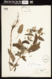 522410[1188030]Cooper, W. S. s.n. Canada, Ontario, Kent |
MIN:Plants | 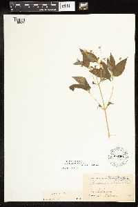 451281[1188031]Wilcox s.n. United States, Nebraska |
MIN:Plants | 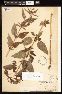 170820[1188032]Watson, J. R. s.n. United States, Ohio, Cuyahoga |
MIN:Plants | 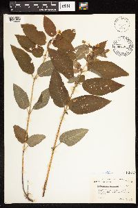 448088[1188033]Abbott, R. S. s.n. United States, New York, Tompkins |
MIN:Plants |  545630[1188034]Rugel, F. 143 United States, Texas, Washington |
MIN:Plants |  403261[1188035]Wadmond, S. C. [3534] United States, Wisconsin, Walworth |
MIN:Plants |  424465[1188036]Hayden, A. 7209 United States, Iowa, Boone |
MIN:Plants |  376968[1188037]Pammel, L. H. s.n. United States, Iowa, Lyon |
MIN:Plants |  414660[1188038]Jones, G. N. 5600 United States, Washington, Pend Oreille |
MIN:Plants |  345800[1188039]Kennedy, G. G. s.n. Canada, Quebec |
MIN:Plants |  386609[1188040]Senn, H. A. 1611 Canada, Ontario, Prescott |
MIN:Plants |  364367[1188041]Jacobs, D. L. 44 Canada, Ontario, Thunder Bay |
MIN:Plants |  605500[1188042]Boivin, B. 9958 Canada, Saskatchewan, Swift Current |
MIN:Plants |  356843[1188043]Elwell, L. H. s.n. United States, Massachusetts, Hampshire |
MIN:Plants |  357020[1188044]Blanchard, W. H. s.n. United States, Massachusetts, Hampshire |
MIN:Plants |  357019[1188045]Blanchard, W. H. s.n. United States, Massachusetts, Hampshire |
MIN:Plants |  170818[1188046]Biltmore Herbarium 3477b United States, North Carolina, Buncombe |
MIN:Plants |  170817[1188047]Fernald, M. L. 289 United States, Maine, Piscataquis |
MIN:Plants |  170832[1188048]Topping, D. L. s.n. United States, District of Columbia |
MIN:Plants |  170831[1188049]Topping, D. L. s.n. United States, District of Columbia |
MIN:Plants |  403260[1188050]Wadmond, S. C. 2816 United States, Wisconsin, Racine |
MIN:Plants |  379658[1188051]Moldenke, E. T. 9932 United States, Vermont, Windham |
MIN:Plants |  170798[1188052]Aiton, G. B. s.n. United States, Idaho, Kootenai |
MIN:Plants |  549098[1188053]Umbach, L.M. 6682 United States, Illinois, DuPage |
MIN:Plants |  487517[1188054]Deane, W. s.n. United States, New Hampshire, Coos |
MIN:Plants |  591041[1188055]Nielsen, E. L. 73 United States, Illinois, Jackson |
MIN:Plants |  480337[1188056]Russell, N. H. 7205221 United States, Iowa, Poweshiek |
MIN:Plants |  487521[1188057]Churchill, J.R. s.n. United States, Illinois, Cook |
MIN:Plants |  551586[1188058]Cotter, S. 1136 United States, Montana, Lake |
MIN:Plants |  170823[1188059]Nelson, A. 1582 United States, Wyoming, Albany |
MIN:Plants |  406237[1188060]Jones, G. N. 17155 United States, Massachusetts, Berkshire |
MIN:Plants |  546360[1188061]Scoggan, H. J. 9172 Canada, Manitoba |
MIN:Plants |  546388[1188062]Scoggan, H. J. 3935 Canada, Manitoba |
MIN:Plants |  170786[1188063]Crandall, C. S. 1011 United States, Colorado, Larimer |
MIN:Plants |  170799[1188064]Camp, S. H. s.n. United States, Michigan, Jackson |
MIN:Plants |  264891[1188065]Pammel, L. H. s.n. United States, Iowa, Clayton |
MIN:Plants |  257364[1188066]Lunell, J. 801 United States, North Dakota, Rolette |
MIN:Plants |  170821[1188067]Ashcroft, G. B. s.n. United States, Ohio, Cuyahoga |
MIN:Plants |  487518[1188068]Deane, W. s.n. United States, New Hampshire, Coos |
MIN:Plants |  305132[1188069]Lunell, J. s.n. United States, North Dakota, Benson |
MIN:Plants |  564660[1188070]Harris, M. E. s.n. United States, Massachusetts, Hampshire |
MIN:Plants |  625266[1188071]Ahles, H. E. 75692 United States, Massachusetts, Hampshire |
MIN:Plants |  656258[1188072]Abair, C. 262-8 United States, Idaho, Minidoka |
MIN:Plants |  451824[1188073]Richards, C. D. 3824 United States, Michigan, Houghton |
MIN:Plants |  570943[1188074]Malte, M. O. 333/22 Canada, Ontario |
MIN:Plants |  578959[1188075]Kaul, R. B. 1428 United States, Montana, Lake |
MIN:Plants |  455044[1188076]Trelease, W. s.n. United States, Connecticut, New Haven |
MIN:Plants |  452449[1188077]Love, D. 5073 Canada, Manitoba |
MIN:Plants |  531441[1188078]Birkenholz, D. s.n. United States, Iowa, Marion |
MIN:Plants |  531477[1188079]Fults, J. L. s.n. United States, Iowa, Lee |
MIN:Plants |  531457[1188080]Fults, J. L. s.n. United States, Iowa, Lee |
MIN:Plants |  278819[1188081]Carpenter, D. S. s.n. United States, Vermont, Rutland |
MIN:Plants |  530822[1188082]Campbell, R. J. s.n. United States, Ohio, Portage |
MIN:Plants |  257387[1188083]Fernald, M. L. 289 United States, Maine, Piscataquis |
MIN:Plants |  385167[1188084]Thatcher, E. P. 44 United States, South Dakota, Lawrence |
MIN:Plants |  170810[1188085]Nelson, A. 7392 United States, Wyoming, Albany |
MIN:Plants |  479499[1188086]Taylor, C. 61 United States, South Carolina, Lexington |
MIN:Plants |  257329[1188087]Lunell, J. 470 United States, North Dakota, Benson |
MIN:Plants |  257385[1188088]Greene, L. s.n. United States, Connecticut, Litchfield |
MIN:Plants |  572371[1188089]Hsi, E. 596 United States, Wisconsin, Ashland |
MIN:Plants |  452389[1188090]Love, D. 5275 Canada, Manitoba |
MIN:Plants |  170789[1188091]Pratt, A. D. s.n. United States, South Dakota, Meade |
MIN:Plants |  170826[1188092]Hardwich, E. J. s.n. United States, Washington, Whitman |
MIN:Plants |  170809[1188093]Lunell, J. s.n. United States, North Dakota, Benson |
MIN:Plants |  257446[1188094]Osterhout, G. E. s.n. United States, Colorado, Weld |
MIN:Plants |  300269[1188095]Lunell, J. 465 United States, North Dakota, Benson |
Google Map
Google Maps is a web mapping service provided by Google that features a map that users can pan (by dragging the mouse) and zoom (by using the mouse wheel). Collection points are displayed as colored markers that when clicked on, displays the full information for that collection. When multiple species are queried (separated by semi-colons), different colored markers denote each individual species.