University of Minnesota
http://www.umn.edu/
612-625-5000
http://www.umn.edu/
612-625-5000
Minnesota Biodiversity Atlas
Bell Museum
Dataset: MIN-Plants
Taxa: Myrsinaceae
Search Criteria: excluding cultivated/captive occurrences
Bell Museum plants | |
 MIN:Plants |  698943[1144139]Sather, Nancy; et al. 2221976-07-02 United States, Minnesota, Saint Louis, Plot 13 St. Louis Co. NE1/4 SW1/4 NW1/4 Sec. 33 T58N R14W;Superior National Forest;058N;14W;33, 47.5115671 -92.0611357 |
MIN:Plants |  698944[1144138]Sather, Nancy; et al. 1261976-06-23 United States, Minnesota, Saint Louis, Skibo Mill; NE1/4 SW1/4 NW1/4 Sec. 36 T58N R13W;;058N;13W;36, 47.4668295 -91.9298347 |
MIN:Plants |  698946[1144140]Sather, Nancy; et al. 2561976-07-15 United States, Minnesota, Saint Louis, Along parking area at Norway Point. St. Louis Co. SW1/4 NW1/4 NE1/4 Sec. 8 T57N R14W;Superior National Forest;057N;14W;08, 47.4367699 -92.1442241 |
MIN:Plants |  699523[1144137_1;1144137_2]Ziegler, S.; et al. 18981975-07-21 United States, Minnesota, Houston, Mississippi River Nav Pool #8, Island 19, Mississippi River-mile #694.6, large island W side of main channel;Upper Mississippi National Wildlife Refuge;104N;03W;31, 43.7687908 -91.250087, 194m |
MIN:Plants |  701131[1144208]Moore, John; Dorio, J. 5161977-07-13 United States, Minnesota, Morrison, Ripley Esker, ca. 3 mi NE of Camp Ripley junction, near ditch N of old field;Ripley Esker Scientific Natural Area;042N;31W;19, 46.1062834 -94.30299 |
MIN:Plants |  701327[1141997]Dorio, J. 3481977-06-23 United States, Minnesota, Benton, Benton Co. Englund Ecotone, ca. 5 mi. SE of Rice. T37N, R31W, Sec. 13.;Englund Ecotone, The Nature Conservancy;037N;31W;13, 45.6985631 -94.1434524 |
MIN:Plants |  701362[1144207]Moore, John; Dorio, J. 3821977-06-28 United States, Minnesota, Morrison, Co.: Morrison ... Sandhill Crane Meadow, 4.5 mi W of Buckman on hwy 34 ... T39N R31W Sec. 3 and 4;Crane Meadows National Wildlife Refuge;039N;31W;, 45.8675303 -94.1989191 |
MIN:Plants |  709398[1144199]Wheeler, Gerald 43901979-07-17 United States, Minnesota, Carver, Carver Co. Approx. 3.5 mi SSW of Carver, about 0.5 mi N of where rte 45 crosses the Minnesota River; T114N R24W Sec. 12;;114N;24W;12, 44.6915235 -93.654586 |
MIN:Plants |  709798[1144198]Wheeler, Gerald 48131979-08-10 United States, Minnesota, Houston, Houston Co. Approx. 2 mi S of Reno on rte 26, adjacent to the Mississippi River; T101N R4W Sec. 2;Upper Mississippi National Wildlife Refuge;101N;04W;2, 43.5798336 -91.2829156 |
MIN:Plants |  711688[1144212]Smith, Welby 17651979-08-30 United States, Minnesota, Dakota, Gores Pool Wildlife Management Area. Dakota Co. 7 mi SE of jnc of hwy 61 and 47 in Hastings, on floodplain of Vermillion River, Gores Pool#3 Wildlife Managem Dakota Co. 7 mi SE of jnc of hwy 61 and 47 in Hastings, on floodplain of Vermillion River, Gores Pool#3 Wildlife Management Area; T114N R16W SE1/4 NE1/4 Sec. 21. 114N 16W 21, 44.6654988 -92.7422849 |
MIN:Plants |  712065[1144213]Smith, Welby 12141979-08-13 United States, Minnesota, Wright, Wright Co.; between Burlington Northern tracks and co. hwy 75, 2.5 mi SE of its jnc with st. hwy 24 in Clearwater; T122N Wright Co.; between Burlington Northern tracks and co. hwy 75, 2.5 mi SE of its jnc with st. hwy 24 in Clearwater; T122N R26W NW1/4 SW1/4 Sec. 11. 122N 26W 11, 45.3847574 -93.9261969 |
MIN:Plants |  715233[1144020]Severson, M.; et al. 761979-07-23 United States, Minnesota, Polk, Malmberg Prairie: 4.5 mi. S of Fischer;Malmberg Prairie Scientific Natural Area;149N;48W;16, 47.7241699 -96.8139653 |
MIN:Plants |  715671[1144134]Keller, C. 991979-07-19 United States, Minnesota, Beltrami, Pennington Orchid Bog SNA, 1 mi N of Pennington; NW1/4 Sec. 3 T146N R30W;Leech Lake Indian Reservation / Pennington Bog Scientific Natural Area;146N;30W;3, 47.491615 -94.4690408 |
MIN:Plants |  717156[1144210]Heitlinger, M. 8571975-08-13 United States, Minnesota, Anoka, Anoka Co. Allison Savanna, in the N central portion of the tract; N1/2 NE1/4 Sec. 2 T33N R23W;Helen Allison Savanna Scientific Natural Area;033N;23W;2, 45.3777015 -93.1738785 |
MIN:Plants |  717506[1144133]Grimmelbein, G. 1161979-07-25 United States, Minnesota, Hubbard, Spearhead Lake Preserve;Spearhead Lake Preserve (Audubon);145N;34W;, 47.3680989 -94.9909661 |
MIN:Plants |  717706[1144211]Farrell, P. 1451979-08-06 United States, Minnesota, Norman, Frenchman's Bluff, 2.5 mi N of Flom; frac. of Sec. 18 T143N R43W;Frenchmans Bluff Scientific Natural Area;143N;43W;18, 47.201968 -96.183894 |
MIN:Plants |  720176[1144204]Ottoson, S.; et al. 1071979-07-16 United States, Minnesota, 2 miles southwest of Fertile.;Agassiz Dunes Scientific Natural Area;;;, 47.51564 -96.31032 |
MIN:Plants |  721113[1144027]Lustig, K. 7731979-07-26 United States, Minnesota, Sherburne, Clear Lake-Mississippi Scenic and Recreational River, SNA, 12 mi SE of St. Cloud; Sec. 14, 22, 23 T34N R30W;Clear Lake Scientific Natural Area;034N;30W;, 45.4463393 -94.0437833 |
MIN:Plants |  721388[1144203]Farrell, P. 1321979-07-18 United States, Minnesota, Polk, 7 mi. SE of Crookston. S1/2 of section;Pankratz Memorial Prairie, The Nature Conservancy;149N;45W;08, 47.73852 -96.44879 |
MIN:Plants |  724799[1144135]Smith, Welby 29251980-07-20 United States, Minnesota, Wright, Wright Co.; On the W bank of the Mississippi River; T121N R25W NE1/4 SE1/4 Sec. 3;;121N;25W;3, 45.3165235 -93.8195109 |
MIN:Plants |  727397[1144136]Ottoson, S. 691979-07-11 United States, Minnesota, Clay, Clay County Bicentennial Prairie, 4 mi SE of Felton; SW1/4 Sec. 5 T141N R45W;Felton Prairie-Bicentennial Prairie Scientific Natural Area;141N;45W;5, 47.0567136 -96.4173556 |
MIN:Plants |  727724[1144148]Lustig, K. 8061979-08-08 United States, Minnesota, Sherburne, Mississippi River Islands Scientific Natural Area. Sherburne & Wright Cos. ...Mississippi River Scenic and Recreational River Islands SNA: Mississippi River Islands between Monticello and Elk River, Sec2, 3, 4, T32N, R26, 27W; Sec7, 9, 18, T121N, R23, 24W. 032N 26W 3, 45.293483 -93.5562457 |
MIN:Plants |  727774[1144129]Severson, M. 1061979-07-25 United States, Minnesota, Polk, Pankratz Prairie South, 7 mi SE of Crookston; SE1/4 of Sec. 17, NE1/4 of Sec. 20 T149N R45W;Pankratz Memorial Prairie, The Nature Conservancy;149N;45W;, 47.7167669 -96.416687 |
MIN:Plants |  728005[1144145]Severson, M. 1741979-08-15 United States, Minnesota, Polk, Pankratz Prairie South: 7 mi SE of Crookston, SE1/4 of Sec17, NE1/4 of Sec20, T149N, R45W.;Pankratz Memorial Prairie, The Nature Conservancy;149N;45W;, 47.7167669 -96.416687 |
MIN:Plants |  728175[1144158]Eikum, B. 1551979-08-14 United States, Minnesota, Dakota, Hastings;Hastings Scientific Natural Area;115N;17W;, 44.73907 -92.86266 |
MIN:Plants |  728263[1144146]Farrell, P. 1011979-07-10 United States, Minnesota, Polk, Pembina Trail Preserve: 6 1/2 mi E of Harold, all Sec36, frac. Sec25, 30, 31, T149N, R45W, frac. Sec1, 2, T148N, R45W.;Pembina Trail Preserve Scientific Natural Area;N;;, 47.702107 -96.357761 |
MIN:Plants |  729476[1144147_1;1144147_2]Converse, C. 4361980-07-08 United States, Minnesota, Pine, Pine Co. St. Croix Natural Area: 21 mi E of Hinckley. SE1/4 NE1/4 Sec34, T41N, R17W.;Saint Croix State Park;041N;17W;34, 45.9906281 -92.4774997 |
MIN:Plants |  729994[1144130]Converse, C. 4751980-07-10 United States, Minnesota, Pine, Kettle River Natural Area, 5.5 mi E of Hinckley; NE1/4 SW1/4 Sec. 15 T41N R20W;Kettle River Scientific Natural Area / Sandstone National Wildlife Refuge;041N;20W;15, 46.0330046 -92.8566204 |
MIN:Plants |  734613[1144149]Severson, M. 6021980-07-29 United States, Minnesota, Clay, Clay County...Bluestem Prairie: 13 mi E of Moorhead. SW1/4 SE1/4 Sec15, T139N, R46W. Riverbank of the Buffalo River.;Bluestem Prairie Scientific Natural Area;139N;46W;15, 46.8549481 -96.4734033 |
MIN:Plants |  734768[1144240]Cross-Cella, J. 2931980-08-27 United States, Minnesota, Becker, Green Water Lake Natural Area: 5 mi W of Posford. NE1/4 NW1/4 Sec33, T141N, R38W.;Greenwater Lake Scientific Natural Area / White Earth Indian Reservation;141N;38W;33, 46.9838935 -95.4976994 |
MIN:Plants |  739417[1144058]Stackler, S. 17551976-07-02 United States, Minnesota, Carlton, Skunk Creek Basin, ca. 6 mi E, 1/2 mi S Barnum. (T45N, R17W, S6);;045N;17W;6, 46.4107361 -92.5413746 |
MIN:Plants |  739547[1144183]Converse, C. 18651982-07-28 United States, Minnesota, Pope, SW1/4 SW1/4 Sec34. Moe Woods: T123N, R36W;Moe Woods, The Nature Conservancy;123N;36W;34, 45.4198101 -95.1833376 |
MIN:Plants |  739552[1144186]Converse, C. 17611982-07-21 United States, Minnesota, Douglas, Staffanson Prairie: T127N, R40W NW1/4 NE1/4 and NE1/4 NW1/4 of Sec18.;Staffanson Prairie, The Nature Conservancy;127N;40W;18, 45.810665 -95.7480052 |
MIN:Plants |  740103[1144184]Converse, C. 16581982-07-14 United States, Minnesota, Pope, SE1/4 SW1/4 Sec34. Moe Woods: T123N, R36W;Moe Woods, The Nature Conservancy;123N;36W;34, 45.4198101 -95.1833376 |
MIN:Plants |  740243[1144185]Converse, C. 15841982-07-12 United States, Minnesota, Pope, SE1/4 NE1/4 Sec30. Ordway Prairie: T123N, R36W N1/2 and N1/2 SE1/4 of Sec30; SW1/4 and S1/2 S1/2 SE1/4 of Sec19.;Ordway Prairie, The Nature Conservancy;123N;36W;30, 45.4342616 -95.2450181 |
MIN:Plants |  741498[1144182]Converse, C. 15451982-07-09 United States, Minnesota, Chippewa, Chippewa / Swift Cos. SW1/4 NE1/4 Sec.13. Chippewa Prairie: T119N, R43W;Chippewa Prairie, The Nature Conservancy;119N;43W;13, 45.1102347 -95.9967661 |
MIN:Plants |  745074[1144187]Smith, Welby 46021981-06-30 United States, Minnesota, Steele, About 1 1/2 mi E-SE of Havana. Strip between U.S. Hwy 14 and the Chicago and Northwestern RR tracks. NE1/4 SW1/4 Sec21, About 1 1/2 mi E-SE of Havana. Strip between U.S. Hwy 14 and the Chicago and Northwestern RR tracks. NE1/4 SW1/4 Sec21, T107N, R19W.. 107N 19W 21, 44.059162 -93.1161483 |
MIN:Plants |  745168[1144188]Smith, Welby 55891981-08-26 United States, Minnesota, Mower, Wild Indigo Scientific Natural Area. Wild Indigo Scientific and Natural Area. About 1/2 mi SW of the jcn of State Hwy 56 and Co. Hwy 2 in Brownsdale. SE1/4 S Wild Indigo Scientific and Natural Area. About 1/2 mi SW of the jcn of State Hwy 56 and Co. Hwy 2 in Brownsdale. SE1/4 SW1/4 Sec9, T103N, R17W.. 103N 17W 9, 43.739626 -92.8792409 |
MIN:Plants |  747048[1144191]Galatowitsch, S. 3881982-07-08 United States, Minnesota, Wabasha, Wabasha County...Weaver Dunes: T109N, R9W Se1/4 and E1/2 NE1/4 of Sec 7; NW1/4 and W1/2 NE1/4 Sec 8.;Kellogg-Weaver Dunes Scientific Natural Area / Kellogg-Weaver Dunes, The Nature Conservancy;109N;09W;00, 44.2331079 -91.9172451 |
MIN:Plants |  747181[1144190]Galatowitsch, S. 4381982-07-14 United States, Minnesota, Houston, Caledonia Oaks: T102N, R5W, E1/2 SW1/4 Sec24.;Caledonia Oaks, The Nature Conservancy;102N;05W;24, 43.6231026 -91.3824233 |
MIN:Plants |  747453[1144189]Galatowitsch, S. 5231982-07-16 United States, Minnesota, Goodhue, Grace Nature Preserve: T109N, R18W parts of NW1/4 SW1/4 and SW1/4 SW1/4 of Sec8.;Grace Nature Preserve, The Nature Conservancy;109N;18W;8, 44.2620117 -93.0105438 |
MIN:Plants |  750222[1144150]Almendinger, J. 801979-10-20 United States, Minnesota, Becker, Becker Co. Just N of Blueberry Lake, NE of S 24, T139N, R36W.;;139N;36W;24, 46.839893 -95.165301 |
MIN:Plants |  750316[1144155]Almendinger, J. s.n.1980-07-27 United States, Minnesota, Hubbard, W shore of Shinker Lake, SW of NW S31, T140N, R33W.;;140N;33W;31, 46.8992099 -94.9022382 |
MIN:Plants |  750440[1144156]Almendinger, J. 57001982-08-15 United States, Minnesota, Hubbard, E of Lake Minnie and between Alcohol Creek and Schoolcraft River, NW of SE of S33, T144N, R34W.;;144N;34W;33, 47.2469969 -94.9944149 |
MIN:Plants |  753114[1144153]Boe, J. 19881983-07-06 United States, Minnesota, Kittson, NW1/4 NE1/4 Sec10. Norway Dunes: E1/2 Sec10; T160, R46W.;Norway Dunes, The Nature Conservancy;160N;46W;10, 48.6957357 -96.5727704 |
MIN:Plants |  753305[1144152]Boe, J. 19651983-07-06 United States, Minnesota, Kittson, SW1/4 SE1/4 SE1/4 Sec10. Norway Dunes: E1/2 Sec10; T160, R46W.;Norway Dunes, The Nature Conservancy;160N;46W;10, 48.6957357 -96.5727704 |
MIN:Plants |  753475[1144175]Duxbury, Alexis 21571983-08-12 United States, Minnesota, Redwood, Redwood Co. Wahpeton Prairie; S1/2 NW1/4 Sec. 29 T110N R38W;Wahpeton Prairie, The Nature Conservancy;110N;38W;29, 44.3047823 -95.4408133 |
MIN:Plants |  753476[1144245]Duxbury, Alexis 20711983-08-08 United States, Minnesota, Lyon, Glynn Prairie; S1/2 NE1/4 Sec. 7 T109N R40W;Glynn Prairie Scientific Natural Area;109N;40W;7, 44.2610945 -95.7045759 |
MIN:Plants |  753477[1144246]Duxbury, Alexis 16111983-07-19 United States, Minnesota, Nobles, Compass Prairie; part of SE1/4 SW1/4 Sec. 3 T101N R41W;Compass Prairie Scientific Natural Area;101N;41W;3, 43.5799411 -95.9835709 |
MIN:Plants |  753478[1144243]Duxbury, Alexis 18901983-08-01 United States, Minnesota, Lincoln, Hole-in-the-Mountain Prairie; portions of S1/2 Sec. 19 and SW1/4 Sec. 20 T109N R45W;Hole-in-the-Mountain Prairie, The Nature Conservancy;109N;45W;, 44.2410821 -96.2617206 |
MIN:Plants |  753480[1144244]Duxbury, Alexis 19541983-08-01 United States, Minnesota, Lincoln, Hole-in-the-Mountain Prairie; portions of S1/2 Sec. 19 and SW1/4 Sec. 20 T109N R45W;Hole-in-the-Mountain Prairie, The Nature Conservancy;109N;45W;, 44.2410821 -96.2617206 |
MIN:Plants | 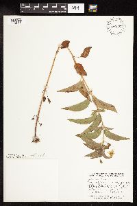 758577[1144160]Smith, Welby 68821982-07-24 United States, Minnesota, Mower, Strip between State Hwy 56 and the C.M.ST.P. & P. rr tracks, about 4 mi NW of LeRoy [Le Roy]. SE1/4 SW1/4 Sec13, T101N, Strip between State Hwy 56 and the C.M.ST.P. & P. rr tracks, about 4 mi NW of LeRoy [Le Roy]. SE1/4 SW1/4 Sec13, T101N, R15W.. 101N 15W 13, 43.5509437 -92.5787555 |
MIN:Plants | 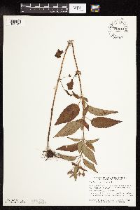 759010[1144159]Smith, Welby 75661982-09-08 United States, Minnesota, Mower, Racine Prairie Scientific Natural Area. Racine Prairie State Scientific and Natural Area. Strip adjacent to the E side of U.S. Trunk Hwy 63, about 2 mi N of Rac Racine Prairie State Scientific and Natural Area. Strip adjacent to the E side of U.S. Trunk Hwy 63, about 2 mi N of Racine. NE1/4 NE1/4 Sec22, T104N, R14W.. 104N 14W 22, 43.7976425 -92.4992666 |
MIN:Plants | 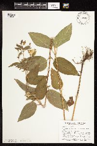 759132[1144161]Smith, Welby 70201982-07-30 United States, Minnesota, Mower, Lake Louise State Park. Lake Louise State Park, about 1 mi N-NW of LeRoy [Le Roy]. NW1/4 SE1/4 sec21, T101N, R14W; on the E side of the Little I Lake Louise State Park, about 1 mi N-NW of LeRoy [Le Roy]. NW1/4 SE1/4 sec21, T101N, R14W; on the E side of the Little Iowa River.. 101N 14W 21, 43.5365784 -92.5190432 |
MIN:Plants | 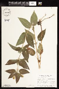 759292[1144157]Smith, Welby 67471982-07-17 United States, Minnesota, Dakota, Dakota Co. Fort Snelling State Park. In the Minnesota Valley 1/2 mi E of Gun Club Lake. SE1/4 NW1/4 Sec4, T27N, R23W.;Fort Snelling State Park;027N;23W;4, 44.8549971 -93.1772975 |
MIN:Plants |  763576[1144022]Lugger, O. s.n. United States, Minnesota, Hubbard, Park Rapids.;;140N;35W;, 46.9352073 -95.0998404 |
MIN:Plants |  765286[1144154]L., D. United States, Minnesota, Hubbard, Park Rapids;;;;, 46.922181 -95.058632 |
MIN:Plants |  766730[1144171]Nelson, Nels 301914-08-07 United States, Minnesota, Todd, Eagel Bend, Minn;;N;;, 46.164939 -95.039404 |
MIN:Plants |  770739[1144169]Smith, Welby 83781983-07-26 United States, Minnesota, Mower, Lake Louise State Park, ca. 1.5 mi NW of LeRoy, on the N bank of the Iowa River; NE1/4 NW1/4 Sec. 28 T101N R14W;Lake Louise State Park;101N;14W;28, 43.5220987 -92.5189584 |
MIN:Plants |  772199[1144174]Boe, J. 7311979-07-12 United States, Minnesota, Lake of the Woods, Near Norris Camp; T159N R35W Sec. 8;;159N;35W;8, 48.6053087 -95.1810755 |
MIN:Plants |  772617[1144164]Boe, J. 9361979-07-19 United States, Minnesota, Lake of the Woods, 6.0 mi SW of Range Line on Rapid River road, roadside near old homestead field;;157N;34W;29, 48.3879361 -95.048032 |
MIN:Plants |  772801[1144021]Boe, J. 8031979-07-15 United States, Minnesota, Lake of the Woods, Northwest Angle. Near Angle Inlet. N1/2 Sec. 31, R34W, T168N.;Northwest Angle;168N;34W;31, 49.3307275 -95.0815356 |
MIN:Plants |  773939[1144172]Boe, J. 6921979-07-10 United States, Minnesota, Lake of the Woods, Long Point, along shore of Lake of the Woods, rock outcrops; T164N R33W SW1/4 Sec. 31;;164N;33W;31, 48.9811938 -94.9492817 |
MIN:Plants |  773940[1144173]Boe, J. 6461979-07-10 United States, Minnesota, Lake of the Woods, Long Point, along shore of Lake of the Woods, rock outcrops; T164N R33W SW1/4 Sec. 31;;164N;33W;31, 48.9811938 -94.9492817 |
MIN:Plants |  774387[1144162]Monson, Paul 55241983-06-20 United States, Minnesota, Saint Louis, Voyageurs National Park. R19W, T69N, NE1/4, NE1/4, S12; Squaw Narrows, Lake Namakan. Island near number 4 day marker.;Voyageurs National Park;069N;19W;12, 48.4774487 -92.7142426 |
MIN:Plants |  774490[1144141]Monson, Paul 52291982-07-30 United States, Minnesota, Saint Louis, Voyageurs National Park. Voyageurs NP. R18W, T68N, SE1/4, NE1/4, S5; Junction Bay, Namakan Lake. Small bay at mouth of Johnson River. Near old ca Voyageurs NP. R18W, T68N, SE1/4, NE1/4, S5; Junction Bay, Namakan Lake. Small bay at mouth of Johnson River. Near old cabin.. 068N 18W 5, 48.404565 -92.6830663 |
MIN:Plants |  782426[1144124]Tenney, M. 3941982-07-07 United States, Minnesota, Fillmore, Forestville State Park. Fillmore Co. T102N R12W Sec. 13 NW1/4 SW1/4 SW1/4; near roadside;Forestville State Park;102N;12W;13, 43.6377242 -92.2192693 |
MIN:Plants |  782657[1144128]Tenney, M. 3711982-07-06 United States, Minnesota, Winona, Whitewater State Park, Winona Co. higher ground in meadow, S side of pond; T107N R10W Sec. 29 SE1/4 NE1/4 NW1/4;Whitewater State Park;107N;10W;29, 44.0420349 -92.0493334 |
MIN:Plants |  782753[1144127]Tenney, M. 4271982-07-15 United States, Minnesota, Fillmore, Forestville State Park. Fillmore Co. T102N R11W Sec. 18 NW1/4 SE1/4 NW1/4; edge of woods near trail;Forestville State Park;102N;11W;18, 43.6379265 -92.199183 |
MIN:Plants |  787623[1144126]Smith, Welby 106771985-07-11 United States, Minnesota, Goodhue, On the banks of the Cannon River, ca. 2.5 mi E of Welch; SW1/4 SW1/4 Sec. 25 T113N R16W;;113N;16W;25, 44.5648115 -92.6823817 |
MIN:Plants |  789507[1144121]Smith, Welby 108181985-07-19 United States, Minnesota, Mahnomen, Mahnomen Co. N side of State Hwy 200, 12 mi E of Mahnomen (town). SE1/4 SW1/4 Sec35, T145N, R40W.;White Earth Indian Reservation;145N;40W;35, 47.3314314 -95.7104867 |
MIN:Plants |  792305[1144125]Smith, Welby 107181985-07-13 United States, Minnesota, Fillmore, Fillmore Co. Deer Creek Valley, about 4.5 mi NW of Wykoff; NE1/4 SE1/4 Sec. 11 T103N R13W;;103N;13W;11, 43.7374992 -92.3491669 |
MIN:Plants |  800289[1144096]Cholewa, A.; et al. 17641989-08-14 United States, Minnesota, Washington, Carpenter Nature Center, Washington Co, T26N R20W S4...North Ravine, delta, S side of outlet stream.;Carpenter Nature Center;026N;20W;04, 44.7688067 -92.8136158 |
MIN:Plants |  800317[1144097]Cholewa, A.; et al. 17581989-07-14 United States, Minnesota, Washington, Carpenter Nature Center. Carpenter Nature Center. Washington Co, T26N R20W S4...North Unit, S end of dirt road along the E border just W of road edge.. 026N 20W 4, 44.7688067 -92.8136158 |
MIN:Plants |  800438[1144214]Smith, Welby 120521986-07-08 United States, Minnesota, Olmsted, Olmsted Co. About 2 mi SSE of Rock Dell (town), and 1/4 mi N of st. hwy 30; SW1/4 SE1/4 Sec. 16 T105N R15W;;105N;15W;16, 43.894722 -92.6255569 |
MIN:Plants |  801004[1144074]Smith, Welby 12477B1986-08-11 United States, Minnesota, Goodhue, Goodhue County...Hay Creek Recreation Area, about 3 mi. S of Red Wing. SW1/4 NE1/4 Sec. 13, T112N, R15W;Dorer Memorial Hardwood State Forest;112N;15W;13, 44.5069427 -92.5588913 |
MIN:Plants |  801222[1144075]Smith, Welby 119641986-07-02 United States, Minnesota, Sherburne, about 2 1/2 mi SE of Santiago. Along the St. Francis River. SW1/4 NW1/4 of section;Sherburne National Wildlife Refuge;035N;28W;23, 45.5075 -93.7938889 |
MIN:Plants |  801278[1144177]Smith, Welby 118501986-06-22 United States, Minnesota, Ramsey, Maplewood Nature Center. Ramsey County ... In the city of Maplewood, about 1/2 mi. S of Larpenteur Ave and 1/2 mi. E of McKnight Road. NW1/4 SE1/4 Sec. 24, T29W, R22W. 029N 22W 24, 44.9838905 -92.9936142 |
MIN:Plants |  804879[1144232]Ordway, E. 1986-07-28 United States, Minnesota, Pope, 4 mi. NE of Starbuck. N end of central marsh.;Strandness Prairie, The Nature Conservancy;125N;38W;06, 45.6651515 -95.5001117 |
MIN:Plants |  814759[1144234]Wheeler, Gerald 117801988-08-16 United States, Minnesota, Norman, Norman County...Ca. 7.5 mi. E of Twin Valley; wildlife area W of Rte. 40. SW1/4 NE1/4 Sec. 26, T144N, R43W, Fossum Twp.;Faith Wildlife Management Area;144N;43W;26, 47.2603473 -96.0987891 |
MIN:Plants |  815900[1144176]Wheeler, Gerald 120261988-09-02 United States, Minnesota, Wilkin, Breckenridge (W side); Welles Memorial Park. Bordering the Otter Tail River. NW1/4 Sec. 9, T132N, R47W (Breckenridge T Breckenridge (W side); Welles Memorial Park. Bordering the Otter Tail River. NW1/4 Sec. 9, T132N, R47W (Breckenridge Twp.).. 132N 47W 9, 46.2613098 -96.5847206 |
MIN:Plants |  817692[1141986]Engels, A. s.n.1991-06-30 United States, Minnesota, Aitkin, Aitkin Co. T49N, R25W, Sec. 33, NW1/4. Engels Farm, ca. 2 1/2 mi. SW of Palisade.;;049N;25W;33, 46.3411666 -93.5043355 |
MIN:Plants |  830035[1141990]Boe, J. 920703021992-07-03 United States, Minnesota, Roseau, Roseau Co.; SW of Badger; SW1/4 NW1/4 Sec 22 T161N R42W;;161N;42W;22, 48.7536239 -96.0628937 |
MIN:Plants |  830197[1144259]Myhre, K. 27951992-07-22 United States, Minnesota, Cass, Cass Co.; Ottertail Peninsula in Leech Lake; T144N R29W NW1/4 of NE1/4 of sec.30;Chippewa National Forest / Leech Lake Indian Reservation;144N;29W;30, 47.2596201 -94.3992237 |
MIN:Plants |  830981[1144057]Cholewa, A. 20431992-06-00 United States, Minnesota, Aitkin, Aitkin Co. Snake River County Park just N of Kanabec Co. line, hwy.95.;Snake River County Park;043N;23W;33, 46.1662966 -93.2519089 |
MIN:Plants |  831053[1144215]Cholewa, A. 20511992-06-00 United States, Minnesota, Aitkin, Aitkin Co. Hwy.65 at Snake River, canoe access on co.rd.61, T44N R23W Sec. 32.;;044N;23W;32, 46.2528633 -93.2721609 |
MIN:Plants |  833530[1144252]Juhnke, C. 1421991-06-24 United States, Minnesota, Fillmore, Forestville State Park. Fillmore Co. T102N R12W Sec.20 NE NE SE; road to Mystery Cave II;Forestville State Park;102N;12W;20, 43.6236562 -92.2986037 |
MIN:Plants |  834267[1144098]Monson, Paul 60591984-08-02 United States, Minnesota, Cook, Grand Portage National Monument; Cook Co, R-6E, T-64N, S-30, Trail intersect with old Hwy.61;Grand Portage National Monument / North Shore;064N;06E;30, 47.9980216 -89.7269288 |
MIN:Plants |  836093[1144255]Smith, Welby 199561991-08-08 United States, Minnesota, Redwood, Redwood Co. In the Minnesota Valley, about 3.5 mi N of Belview. T114N R37W NE1/4 of SE1 Redwood Co. In the Minnesota Valley, about 3.5 mi N of Belview; T114N R37W NE1/4 of SE1/4 of Sec 19. 114N 37W 19, 44.6630554 -95.461113 |
MIN:Plants |  837315[1141994]Smith, Welby 174571990-07-27 United States, Minnesota, Morrison, Picnic area #3, on the floodplain of the Mississippi River. UTM: 393800E 5108900N. SE1/4 of SE1/4 of Section;Camp Ripley Military Reservation;131N;29W;30, 46.12541 -94.3746344 |
MIN:Plants |  837354[1144256]Smith, Welby 183861990-09-13 United States, Minnesota, Morrison, about 2 km NW of Crow Wng Lake; floodplain of the Mississippi River; UTM: 394500E 5122500N. SW1/4 of NW1/4 of section;Camp Ripley Military Reservation;132N;29W;17, 46.2478839 -94.3686103 |
MIN:Plants |  838368[1141991]Smith, Welby 178101990-08-08 United States, Minnesota, Red Lake, Red Lake County ... At 'Old Crossing Treaty State Wayside Park'. On the N bank of the Red Lake River, about 6 miles W of the town of Red Lake Falls ... T151N R45W SE1/4 of SW1/4 of Sec. 27. 151N 45W 27, 47.8666649 -96.4113922 |
MIN:Plants |  839156[1141988]Smith, Welby 176701990-08-02 United States, Minnesota, Dodge, Dodge Co. On the N side of Dodge Center Creek in Dodge Center Creek Park, about 1 mi W of the town of Dodge Center; Dodge Co. On the N side of Dodge Center Creek in Dodge Center Creek Park, about 1 mi W of the town of Dodge Center; T107N R17W SW1/4 of SW1/4 of Sec 28.. 107N 17W 28, 44.040554 -92.8780518 |
MIN:Plants |  839344[1141989]Cholewa, A.; Engels, A. 23601995-07-27 United States, Minnesota, Aitkin, Savanna Portage State Park. Aitkin Co. Savanna Portage State Park, about 17 mi NE of McGregor, NW side of Wolf Lake along NW edge of old homesite, T Aitkin Co. Savanna Portage State Park, about 17 mi NE of McGregor, NW side of Wolf Lake along NW edge of old homesite, T50N R22W S6 NE1/4 of NE1/4.. 050N 22W 6, 46.845996 -93.1774497 |
MIN:Plants |  841130[1144043]Smith, Welby 134581987-07-13 United States, Minnesota, Scott, Murphy-Hanrahan County Park Reserve. Scott County...Murphy-Hanrahan Regional Park, on the S side of Hanrahan lake, about 2 mi W of Burnsville. SW1/4 NW1/4 sec. 34, T115N R21W. 115N 21W 34, 44.7277778 -93.3363889 |
MIN:Plants |  841648[1144042]Smith, Welby 133811987-07-07 United States, Minnesota, Washington, Falls Creek Scientific Natural Area. Washington Co. About 2 mi NE of Scandia; ravine that drains E into the St. Croix River. SE1/4 SE1/4 SW1/4 sec.7, T32N R1 Washington Co. About 2 mi NE of Scandia; ravine that drains E into the St. Croix River. SE1/4 SE1/4 SW1/4 sec.7, T32N R19W. 032N 19W 7, 45.2737586 -92.7654752 |
MIN:Plants |  438068[1144235]Juhnke, C. 424 CMJ FRO1999-07-04 United States, Minnesota, Goodhue, Frontenac State Park Goodhue County ... Along Hill Ave. west of bridge ... T112N R13W SWSWNE 5;Frontenac State Park;112N;13W;05, 44.5351964 -92.3999731 |
MIN:Plants |  913251[1144218]Smith, Welby 255051994-09-13 United States, Minnesota, Murray, Lake Shetek State Park. Murray County ... Lake Shetek State Park, about 3 miles northwest of Currie ... shore of Lake Shetek ... T107N R40W SW1/4 of SW1/4 of Sec 31. 107N 40W 31, 44.1111111 -95.7011111 |
MIN:Plants |  910091[1144076]Smith, Welby 246951994-07-13 United States, Minnesota, Polk, Polk County ... About 5 miles southwest of Erskine ... T148N R43W NE1/4 of NW1/4 of Sec 25;;148N;43W;25, 47.6094444 -96.0797222 |
MIN:Plants |  170811[1188916]White, Sidney s.n.1889-07-11 United States, Wisconsin, Buffalo, Fountain City |
Google Map
Google Maps is a web mapping service provided by Google that features a map that users can pan (by dragging the mouse) and zoom (by using the mouse wheel). Collection points are displayed as colored markers that when clicked on, displays the full information for that collection. When multiple species are queried (separated by semi-colons), different colored markers denote each individual species.