University of Minnesota
http://www.umn.edu/
612-625-5000
http://www.umn.edu/
612-625-5000
Minnesota Biodiversity Atlas
Bell Museum
Dataset: MIN-Plants
Taxa: Myrsinaceae
Search Criteria: excluding cultivated/captive occurrences
Bell Museum plants | |
 MIN:Plants |  527209[1144717]Lakela, Olga 178281954-07-12 United States, Minnesota, Saint Louis, St. Louis County...Trout River, above the falls, Trout Lake Portage between Trout and Vermillion Lake.;Boundary Waters Canoe Area Wilderness / Superior National Forest;063N;16W;24, 47.9243525 -92.3193738 |
MIN:Plants |  532620[1144656]Lakela, Olga 198321956-06-16 United States, Minnesota, Saint Louis, Seven Beaver Lake N end of the narrows.;;N;;, 47.507798 -91.806451 |
MIN:Plants |  532881[1144651]Lakela, Olga 200171956-06-24 United States, Minnesota, Saint Louis, Small lake S of Pelican Lake, Orr.;Kabetogama State Forest;N;;, 48.018332 -92.919684 |
MIN:Plants |  532934[1144848]Lakela, Olga 210241956-06-29 United States, Minnesota, Saint Louis, Prairie Lake.;;050N;20W;, 46.809279 -92.8706753 |
MIN:Plants |  533112[1144840]Lakela, Olga 199441956-06-21 United States, Minnesota, Saint Louis, Pine Lake, S of Seven Beaver Lake, Headwaters of St. Louis River.;;N;;, 47.494056 -91.845332 |
MIN:Plants |  542678[1144839]Moore, John 217611952-06-05 United States, Minnesota, Brown, S shore of Lake Hanska, Sec24, Albin Twp.;;108N;32W;24, 44.1452043 -94.629543 |
MIN:Plants |  550923[1144670]Cotter, Shirley 19431951-06-24 United States, Minnesota, Anoka, N side of Nursery road. Carlos Avery Game Refuge.;Carlos Avery Wildlife Management Area;N;;, 45.288565 -93.129351 |
MIN:Plants |  553918[1144785]Moore, John 225701955-06-03 United States, Minnesota, Sibley, Sibley Co. Along the E shore of Silver Lake, Jessenland Twp.;;113N;26W;, 44.586561 -93.9500898 |
MIN:Plants |  566473[1144812]Moore, John 239381958-06-14 United States, Minnesota, Kittson, 5 mi. NW of Lake Bronson.;;N;;, 48.786674 -96.7404 |
MIN:Plants |  568514[1144773]Moore, John 250221960-06-16 United States, Minnesota, Kittson, 1/2 mi. S of Twin churches NE of Lancaster.;;N;;, 48.851079 -96.804215 |
MIN:Plants |  568637[1144808]Moore, John; Ferguson, A. 249441960-06-07 United States, Minnesota, Blue Earth, At the base of Minnesota River bluffs, 3 mi. W of Mankato.;;N;;, 44.160657 -94.067139 |
MIN:Plants |  572848[1144779]Moore, John 255681961-07-06 United States, Minnesota, Isanti, S shore of Ice Lake, Cedar Creek Natural History Area.;Cedar Creek National History Area;034N;23W;, 45.4273233 -93.0810767 |
MIN:Plants |  574600[1144804]Moore, John 245901959-06-04 United States, Minnesota, Blue Earth, Judson.;;109N;28W;, 44.2396867 -94.1904919 |
MIN:Plants |  574720[1144809]Moore, John 247481959-07-30 United States, Minnesota, Kittson, 3 1/2 mi. NW of Lake Bronson.;;N;;, 48.771337 -96.717126 |
MIN:Plants |  582444[1144805]Isaak, Daniel s.n.1958-00-00 United States, Minnesota, Clearwater, Itasca State Park. Across the hwy. for the [UM Forestry] Biological Station.;Itasca State Park;143N;36W;, 47.19557 -95.2332161 |
MIN:Plants |  583847[1144741]Gunderson, R. 2511961-06-14 United States, Minnesota, Washington, St. Croix River, 3 mi N of Stillwater.;Saint Croix National Riverway;030N;20W;, 45.08498 -92.81735 |
MIN:Plants |  584723[1144821]Morean, Edith s.n.1962-06-10 United States, Minnesota, Dakota, Dakota Co. E of Savage. Kramer gravel pit.;;115N;21W;, 44.76556 -93.292704 |
MIN:Plants |  585289[1144768]Moore, John 259711962-05-30 United States, Minnesota, Pipestone, Pipestone Co.; along the railroad 2 mi. southwest of Ruthon.;;108N;44W;, 44.1533145 -96.1241036 |
MIN:Plants |  592039[1144829]Moore, John; et al. 267371965-06-16 United States, Minnesota, Isanti, E shore of Beckman Lake, Cedar Creek Natural History Area.;Cedar Creek National History Area;034N;23W;, 45.4280632 -93.2039968 |
MIN:Plants |  594499[1144720]Thorne, Robert 305871962-06-23 United States, Minnesota, Clearwater, Clearwater Co. NW part of Bear Paw Point, between the N and E arms of Lake Itasca, Itasca State Park.;Itasca State Park;143N;36W;11, 47.2175215 -95.2014955 |
MIN:Plants |  602217[1144721]Westkaemper, Remberta s.n.1966-08-00 United States, Minnesota, Stearns, Stearns Co. St. Joseph.;;124N;29W;, 45.543642 -94.322053 |
MIN:Plants |  611486[1144780]Lammers, Roberta s.n.1968-06-21 United States, Minnesota, Isanti, S of Beckman Lake, Cedar Creek Natural History Area.;Cedar Creek National History Area;034N;23W;, 45.4280632 -93.2039968 |
MIN:Plants |  616709[1144719]Moore, John; Moore, Marjorie 1561969-06-17 United States, Minnesota, Crow Wing, Along the E shore of Chandler Lake, SW1/4 Sec. 22, Garrison Twp.;Crow Wing Natural Area;044N;28W;22, 46.2789902 -93.8633363 |
MIN:Plants |  627735[1144659]Ownbey, Gerald 45791972-07-09 United States, Minnesota, Cass, Cass Co. Boy River Bog, 3 mi E of Boy River, N1/2 NE1/4 Sec23, T143N, R27W. Along drainage ditch, edge of road.;Chippewa National Forest;143N;27W;23, 47.1889536 -94.06198 |
MIN:Plants |  657115[1144828]Scanlan, M. 1531973-08-30 United States, Minnesota, Swift, Swift Co. Collected in SW-274 (Sec14, T120N, R43W) a 10 - acre forest on the E bank of the Pomme de Terre R.;;120N;43W;14, 45.2028241 -96.0106906 |
MIN:Plants |  669721[1144678]Wheeler, Gerald s.n.1974-07-22 United States, Minnesota, Meeker, 1 mi E of Lake Ripley; near Litchfield.;;N;;, 45.106813 -94.512777 |
MIN:Plants |  669829[1144774]Wheeler, Gerald s.n.1974-06-22 United States, Minnesota, Aitkin, 10 mi. N of Aitkin. Next to Hwy. 169 (on the E side of the road).;;N;;, 46.661708 -93.61326 |
MIN:Plants |  670686[1144674]Heitlinger, M. 3631971-08-29 United States, Minnesota, McLeod, SE1/4 of Sec 34, T115N, R29W. [2 sites and] SE corner of tract.;Schaefer Prairie, The Nature Conservancy;115N;29W;34, 44.7250496 -94.3049103 |
MIN:Plants |  672602[1144673]Wheeler, Gerald s.n.1972-07-16 United States, Minnesota, Meeker, Approximately 1/4 mi E of Lake Ripley near Litchfield.;;N;;, 45.107056 -94.522415 |
MIN:Plants |  679117[1144706]Newcomb, Eloise 1051941-05-25 United States, Minnesota, Anoka, Cedar Creek Bog.;Cedar Creek National History Area;034N;23W;, 45.4280632 -93.2039968 |
MIN:Plants |  680718[1144709]Clemants, Steven 7091977-05-27 United States, Minnesota, Crow Wing, Cross Lake. T137N, R27W, Sec. 30 NE1/4.;Crow Wing State Forest;137N;27W;30, 46.6531384 -94.1459091 |
MIN:Plants |  681105[1144708]Swanson, Steven 9221975-06-25 United States, Minnesota, Houston, Mississippi River (Navigation Pool #8). Houston Co, Site 29.;Upper Mississippi National Wildlife Refuge;N;;, 43.575557 -91.264979 |
MIN:Plants |  682026[1144707]Herje, S. s.n.1977-05-29 United States, Minnesota, Crow Wing, On an island, N end of Rush Lake, Whitefish chain.;;N;;, 46.695805 -94.130981 |
MIN:Plants |  687015[1144796]Wheeler, Gerald; Glaser, Paul 14411977-05-28 United States, Minnesota, Itasca, NW1/4 SW1/4 Sec. 24 T55N, R27W; ca. 7.5 mi. W of Grand Rapids.;;055N;27W;24, 47.2321543 -93.7132723 |
MIN:Plants |  687168[1144797]Wheeler, Gerald; Glaser, Paul 15961977-06-04 United States, Minnesota, Itasca, SW1/4 SE1/4 Sec. 18, T57N, R25W; ca. 12.5 mi. N-NW of Grand Rapids.;Chippewa National Forest;057N;25W;18, 47.4219717 -93.5676448 |
MIN:Plants |  690553[1144765]Siemers, Ross 361977-06-16 United States, Minnesota, Stearns, Stearns Co. Roscoe Prairie. 2 mi SE of Roscoe on Hwy. 16. T123N, R32W, Sec. 35.;Roscoe Prairie Scientific Natural Area;123N;32W;35, 45.4195202 -94.6709243 |
MIN:Plants | 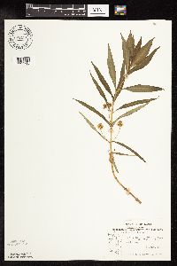 691181[1144710]Sperling, C. 2271976-06-06 United States, Minnesota, Douglas, 2 mi. S, 1 mi. W of Garfield.;;N;;, 45.911835 -95.512797 |
MIN:Plants | 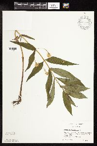 691462[1144711]Clemants, Steven 13341978-06-20 United States, Minnesota, Crow Wing, Ca. 3 mi. N of Cuyuna. 1.5 mi. E of CO. Rd. 6 on Co. Rd. 11.;;136N;26W;26, 46.5649894 -93.9214244 |
MIN:Plants | 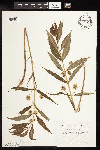 696551[1144827]Smith, Welby 8411978-06-11 United States, Minnesota, Wright, Wright Co. T119N, R25W, SW1/4 Sec28; Near N fork of Crow River.;;119N;25W;28, 45.0866538 -93.8381016 |
MIN:Plants | 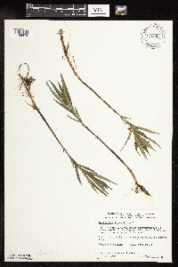 698063[1144675]Wheeler, Gerald; Glaser, Paul 28631978-05-31 United States, Minnesota, Beltrami, Approximately 14.5 mi N of the Waskish Airport on Rte 72, about 0.5 mi W of the road. Coll. Site No. 1.;Red Lake Peatland Scientific Natural Area;156N;31W;1, 48.3236699 -94.6182791 |
MIN:Plants |  698131[1144743]Wheeler, Gerald; Glaser, Paul 29311978-06-08 United States, Minnesota, Beltrami, Ca. 12 mi. N of the Washkish Airport on Rte. 72, ca. 0.1 mi. W of the road.;Red Lake Peatland Scientific Natural Area;156N;31W;13, 48.3306232 -94.5647671 |
MIN:Plants |  698942[1144672]Sather, Nancy; et al. 4101977-06-16 United States, Minnesota, Lake, Lake Co, Denley Lake, SE1/4 NE1/4, S2, T60N, R11W.;Superior National Forest;060N;11W;02, 47.7123343 -91.6865432 |
MIN:Plants |  700623[1144668]Ownbey, Gerald 59521978-06-21 United States, Minnesota, Clearwater, Red Lake Indian Reservation. T151N, R36W, NW1/4 Sec22; SW corner of Lower Red Lake, along Minn. rtes. 1 & 89, 1 mi N of its jcn with Clearbrook hwy. T151N, R36W, NW1/4 Sec22; SW corner of Lower Red Lake, along Minn. rtes. 1 & 89, 1 mi N of its jcn with Clearbrook hwy. W side of hwy.. 151N 36W 22, 47.8810163 -95.2495156 |
MIN:Plants |  709028[1144740]Wheeler, Gerald 40161979-06-22 United States, Minnesota, Washington, Saint Croix National Riverway. Washington County ... Approx. 3 mi. S of Marine on St. Croix ... 1 mi. N of the St. Croix Islands Scenic Overlook on Rte. 95. Near the St. Croix River.. 031N 19W , 45.1572286 -92.7645945 |
MIN:Plants |  709806[1144795]Wheeler, Gerald 48211979-08-10 United States, Minnesota, Houston, Houston Co. Approx. 2 mi. S of Reno on Rte. 26, adjacent to the Mississippi River. T10N, R4W, Sec. 2.;Upper Mississippi National Wildlife Refuge;101N;04W;2, 43.5798336 -91.2829156 |
MIN:Plants |  715187[1144766]Severson, M. 361979-06-25 United States, Minnesota, Polk, 4.5 mi. S of Fischer, W1/2 of NW1/4 of Sec;Malmberg Prairie Scientific Natural Area;149N;48;16, 47.7241699 -96.8139653 |
MIN:Plants |  715410[1144817]Farrell, P. 501979-06-28 United States, Minnesota, Beltrami, Lake Bemidji Bog SNA: 1 mi. NW of Lake Bemidji, N1/2 of NW1/4 of Sec. 24, T147N, R33W.;Lake Bemidji State Park;147N;33W;24, 47.5332086 -94.810311 |
MIN:Plants |  715589[1144816]Kellner, C. 431979-06-28 United States, Minnesota, Beltrami, Pennington Orchid Bog SNA: 1 mi. N of Pennington, NW1/4 Sec. 3, T146N, R30W.;Leech Lake Indian Reservation / Pennington Bog Scientific Natural Area;146N;30W;3, 47.491615 -94.4690408 |
MIN:Plants |  715644[1144815]Kellner, C. 591979-07-05 United States, Minnesota, Beltrami, Pennington Orchid Bog SNA: 1 mi. N of Pennington, NW1/4 Sec. 3, T146N, R30W.;Leech Lake Indian Reservation / Pennington Bog Scientific Natural Area;146N;30W;3, 47.491615 -94.4690408 |
MIN:Plants |  717184[1144819]Heitlinger, M. 6831975-06-27 United States, Minnesota, McLeod, Schaefer Prairie. On th e W side of an area in NE and E central portion of the tract. SE1/4 of Sec. 34, T115N, R29W.;Schaefer Prairie, The Nature Conservancy;115N;29W;34, 44.7250496 -94.3049103 |
MIN:Plants |  717546[1144818]Mathisen, Ron 1001979-07-05 United States, Minnesota, Hubbard, Spearhead Lake Reserve.;Spearhead Lake Preserve (Audubon);145N;34W;, 47.3680989 -94.9909661 |
MIN:Plants |  722634[1144671]Lustig, K. 4131979-06-06 United States, Minnesota, Anoka, Anoka County...Boot Lake SNA: 18 mi SE of Cambridge, sec. 17, 18, 19, 20, T33N, R22W.;Boot Lake Scientific Natural Area;033N;22W;00, 45.3479647 -93.1130211 |
MIN:Plants |  722698[1144658]Lustig, K. 4971979-06-14 United States, Minnesota, Anoka, Anoka County...Boot Lake SNA: 18 mi SE of Cambridge, sec. 17, 18, 19, 20, T33N, R22W.;Boot Lake Scientific Natural Area;033N;22W;00, 45.3479647 -93.1130211 |
MIN:Plants |  724000[1144669]Smith, Welby 24091980-06-10 United States, Minnesota, Douglas, T127N, R39W, NW1/4 SW1/4 NE1/4 Sec32.;;127N;39W;32, 45.7666602 -95.603289 |
MIN:Plants |  724243[1144698]Smith, Welby 22831980-06-01 United States, Minnesota, Wright, Wright Co.; T121N, R28W, NW1/4 NE1/4 Sec. 25. N side of Hwy. 55, 1 mi. W of Annandale.;;121N;28W;25, 45.2605911 -94.1472522 |
MIN:Plants |  724276[1144697]Smith, Welby 36451980-09-07 United States, Minnesota, Wright, Wright Co.; T122N, R27W, NE1/4 SE1/4 sec. 34. Succonix State Wildlife Management Area. About 5 1/2 mi. S of Clearwater.;Suconnix Wildlife Management Area;122N;27W;34, 45.3329325 -94.0659822 |
MIN:Plants |  724741[1144679]Smith, Welby 23901980-06-05 United States, Minnesota, Stevens, Pepperton Wildlife Management Area. Stevens Co.; T 125N, R 43W; NW1/4 SE1/4 SW1/4 Sec. 15. About 3/4 mi. west of County Road 9 and 1/8 mi. N of the gravel road.. 125N 43W 15, 45.6362769 -96.0571399 |
MIN:Plants |  727149[1144732]Herman, J. 381979-06-21 United States, Minnesota, Norman, Twin Valley Prairie: 5 mi. W of Syre, NW1/4 E1/2 SW1/4 of Sec. 23, T143N, R45W (TNC).;Twin Valley Prairie Scientific Natural Area;143N;45W;23, 47.1875161 -96.3538078 |
MIN:Plants |  727279[1144700]Smith, Welby 24921980-06-12 United States, Minnesota, Saint Louis, On the N side of Co. Rd. 8, ca. 13 mi. due E of Floodwood.;;051N;18W;4, 46.9341965 -92.628406 |
MIN:Plants |  727485[1144667]Smith, Welby 22881980-06-01 United States, Minnesota, Wright, Wright Co.; T120N, R26W, SE1/4 NE1/4 Sec8; 1/4 mi S of State Hwy 55, and about 1 1/2 mi E-SE of the town of Maple Lake.;;120N;26W;8, 45.2167078 -93.9810292 |
MIN:Plants |  727502[1144699]Severson, M. 741979-06-26 United States, Minnesota, Polk, Pembina Trail Preserve Scientific Natural Area. Polk County...Pembina Trail Preserve...6 1/2 mi. E of Harold, all sec. 36, frac. sec. 25, 30, 31, T149N, R45W, frac. sec. 1, 2, T148N, R45W.., 47.702107 -96.357761 |
MIN:Plants |  728032[1144694]Severson, M. 391979-06-22 United States, Minnesota, Polk, Pankratz Prairie South: 7 mi. SE of Crookston, SE1/4 of Sec. 17, NE1/4 of Sec. 20, T149N, R45W.;Pankratz Memorial Prairie, The Nature Conservancy;149N;45W;, 47.7167669 -96.416687 |
MIN:Plants |  728121[1144681]Ottoson, S. 551979-06-21 United States, Minnesota, Mahnomen, Mahnomen Co. Santee Prairie: 3 mi SE of Bejou, Sec. 6, 7, T145N, R41W;Santee Prairie Scientific Natural Area / White Earth Indian Reservation;145N;41W;, 47.3684247 -95.8691217 |
MIN:Plants |  728652[1144696]Wheeler, Gerald 53621980-07-18 United States, Minnesota, Ramsey, Ramsey Co.; Roseville. E side of Little Lake Josephine (between Lake Josephine and Lake Owasso). T29W, R23W, Sec. 2.;;029N;23W;2, 45.0282825 -93.1365457 |
MIN:Plants |  729053[1144693]Converse, C. 821980-06-02 United States, Minnesota, Chisago, Goose Creek Natural Area: 5 mi. SE of Rush City. SE1/4 SW1/4 Sec. 6, T36, R20W.;Wild River State Park;036N;20W;, 45.6366816 -92.8932544 |
MIN:Plants |  729446[1144691]Phelps, V. 181980-06-19 United States, Minnesota, Pine, Pine Co. St. Croix Natural Area: 21 mi. N of Hinckley. NW1/4 NW1/4 Sec. 34, T41N, R17W.;Saint Croix State Park;041N;17W;34, 45.9906281 -92.4774997 |
MIN:Plants |  729610[1144692_1;1144692_2]Cutler, S. 51980-06-09 United States, Minnesota, Pine, Pine Co. St. Croix Natural Area: 21 mi. E of Hinckley. NE1/4 NW1/4 Sec. 4, T040N, R17W.;Saint Croix State Park;040N;17W;4, 46.0628066 -92.4984637 |
MIN:Plants |  729708[1144685_1;1144685_2]Converse, C. 1331980-06-04 United States, Minnesota, Pine, Pine Co. Kettle River Natural Area: 5.5 mi. E of Hinckley. NW1/4 SW1/4 Sec. 23, T41N, SW1/4.;Kettle River Scientific Natural Area / Sandstone National Wildlife Refuge;041N;20W;23, 46.0186087 -92.8357974 |
MIN:Plants |  730126[1144695]Converse, C. 1061980-06-03 United States, Minnesota, Chisago, Rush Lake Island Natural Area: 7 mi. W-SW of Rush City. SE1/4 SW1/4 Sec. 21, T37N, R22W.;Rush Lake Island Scientific Natural Area;037N;22W;21, 45.6805023 -93.0936302 |
MIN:Plants |  730646[1144686]Petron, T. 621980-06-09 United States, Minnesota, Wilkin, Western Prairie South: 6.5 mi. NW of Rothsay. SE1/4 NW1/4 Sec. 12, T135N, R46W..;Western Prairie South Scientific Natural Area;135N;46W;12, 46.5218159 -96.4144162 |
MIN:Plants |  730738[1144688]Benson, Douglas 851981-06-11 United States, Minnesota, Wilkin, Anna Gronseth Prairie: T134N, R45W, NW1/4 NW1/4, SW corner Sec. 9.;Anna Gronseth Prairie, The Nature Conservancy;134N;45W;9, 46.4348561 -96.3542192 |
MIN:Plants |  730744[1144687]Benson, Douglas 1401981-06-24 United States, Minnesota, Wilkin, Kettledrummer: T133N, R45W, NW1/4 NW1/4 NW1/4 Sec. 12.;Kettledrummer Prairie, The Nature Conservancy;133N;45W;12, 46.3479066 -96.2909818 |
MIN:Plants |  730768[1144680]Benson, Douglas 1621981-06-29 United States, Minnesota, Wilkin, Town Hall Prairie. NE corner of SE1/4 SW1/4 Sec. 15, T134N, R45W.;Town Hall Prairie, The Nature Conservancy;134N;45W;15, 46.4203322 -96.3331826 |
MIN:Plants |  732562[1144689]Cross-Cella, J. 991980-06-06 United States, Minnesota, Becker, Zimmerman Prairie: 10 mi. W of Ogema. E 1/2 SW1/4 Sec. 16, T142N, R43W.;Zimmerman Prairie [TNC];142N;43W;16, 47.1150258 -96.1414196 |
MIN:Plants |  734645[1144684]Severson, M. 2521980-06-03 United States, Minnesota, Clay, Bluestem Prairie: 13 mi. E of Moorhead. NW1/4 NE1/4 Sec. 15, T139N, R46W.;Bluestem Prairie Scientific Natural Area;139N;46W;15, 46.8549481 -96.4734033 |
MIN:Plants |  740031[1144683]Converse, C. 10641982-06-08 United States, Minnesota, Pope, Ordway Prairie: T123N, R36W, E1/2 NW1/4 Sec. 30.;Ordway Prairie, The Nature Conservancy;123N;36W;30, 45.4342616 -95.2450181 |
MIN:Plants |  740066[1144690]Converse, C. 11331982-06-13 United States, Minnesota, Douglas, Staffanson Prairie: T127N, R40W, NW1/4 NE1/4 and NE1/4 NW1/4 of Sec. 18.;Staffanson Prairie, The Nature Conservancy;127N;40W;18, 45.810665 -95.7480052 |
MIN:Plants |  740158[1144682]Converse, C. 9841982-06-03 United States, Minnesota, Pope, Moe Woods. SE1/4 SW1/4 Sec. 34, T123N, R36.;Moe Woods, The Nature Conservancy;123N;36W;34, 45.4198101 -95.1833376 |
MIN:Plants |  741524[1144742]Converse, C. 11231982-06-11 United States, Minnesota, Otter Tail, Otter Tail Preserve. SW1/4 SE1/4 Sec. 17, T131N, R44W, E1/2 of Sec. 17.;Ottertail Prairie Scientific Natural Area;N;;, 46.1592444 -96.2353633 |
MIN:Plants |  744940[1144748]Smith, Welby 41211981-06-06 United States, Minnesota, Wright, Wright Co.; at the NE end of a small unnamed lake in Hanover. NW1/4 SE1/4 Sec. 35, T120N, R24W.;;120N;24W;35, 45.1533533 -93.6683201 |
MIN:Plants |  745075[1144746]Smith, Welby 45781981-06-30 United States, Minnesota, Steele, Ca. 3 mi. NW of Bixby and 200 meters NW of the Turtle Creek crossing. Prairie strip between Hwy. 218 and the Chicago, M Ca. 3 mi. NW of Bixby and 200 meters NW of the Turtle Creek crossing. Prairie strip between Hwy. 218 and the Chicago, Milwaukee, St. Paul and Pacific R.R. tracks. SE1/4 SE1/4 Sec. 17, T106N, R19W.. 106N 19W 17, 43.9864174 -93.1360604 |
MIN:Plants |  745190[1144747]Smith, Welby 43001981-06-16 United States, Minnesota, Chippewa, Lac Qui Parle Wildlife Management Area. Chippewa Co. Just SW of the jct. of Co. Rd. 32 and Hwy. 12, about 2 1/2 mi. SE of Milan. SW1/4 NW1/4 Sec. 36, T119N, R4 Chippewa Co. Just SW of the jct. of Co. Rd. 32 and Hwy. 12, about 2 1/2 mi. SE of Milan. SW1/4 NW1/4 Sec. 36, T119N, R42W.. 119N 42W 36, 45.072358 -95.8678484 |
MIN:Plants |  745437[1144745]Smith, Welby 42401981-06-13 United States, Minnesota, Wright, Wright Co.; about 1 3/4 mi. SE of Silver Creek, and S of Hwy. 39. NW1/4 NW1/4 Sec. 15, T121N, R26W.;;121N;26W;15, 45.2894056 -93.9432038 |
MIN:Plants |  745438[1144744]Smith, Welby 42561981-06-13 United States, Minnesota, Wright, Wright Co.; about 1/2 SW of Hasty. SW1/4 NE1/4 Sec. 20, T122N, R26W.;;122N;26W;20, 45.3621729 -93.9836744 |
MIN:Plants |  753497[1144737]Duxbury, Alexis 11951983-06-16 United States, Minnesota, Murray, Lundblad Prairie.;Lundblad Prairie Scientific Natural Area;105N;41W;1, 43.9278165 -95.7133858 |
MIN:Plants |  758820[1144749]Smith, Welby 65131982-06-29 United States, Minnesota, Le Sueur, LeSueur Co. On the W side of Hwy. 23, about 2 mi NE of St. Peter, in the Minnesota Valley. NE1/4 NW1/4 Sec. 11, R26W.;;110N;26W;11, 44.348192 -93.9191723 |
MIN:Plants |  759201[1144750_1;1144750_2]Smith, Welby 73021982-08-15 United States, Minnesota, Wright, Wright Co.; on the S side of Hwy. 12, about 1 mi. E of Howard Lake. NW1/4 NW1/4 Sec. 2, T118N, R27W.;;118N;27W;2, 45.0582483 -94.0429651 |
MIN:Plants |  759335[1144751]Smith, Welby 61311982-06-06 United States, Minnesota, McLeod, Ras-Lynn Wildlife Management Area. Ras-Lynn State Wildlife Management Area. On the W side of Eagle Lake, ca. 7 mi. SW of Hutchinson. NW1/4 SW1/4 Sec. 33, Ras-Lynn State Wildlife Management Area. On the W side of Eagle Lake, ca. 7 mi. SW of Hutchinson. NW1/4 SW1/4 Sec. 33, T116N, R30W.. 116N 30W 33, 44.8124739 -94.4471087 |
MIN:Plants |  759370[1144752]Smith, Welby 60671982-05-26 United States, Minnesota, Nicollet, Nicollet Co.; in the Minnesota Valley. On the E side of Hwy. 169, ca. 2 1/2 mi. S-SW of Le Sueur. NE1/4 NE1/4 Sec. 16, Nicollet Co.; in the Minnesota Valley. On the E side of Hwy. 169, ca. 2 1/2 mi. S-SW of Le Sueur. NE1/4 NE1/4 Sec. 16, T111N, R26W.. 111N 26W 16, 44.4205382 -93.9597699 |
MIN:Plants |  763578[1144756]Lugger, O. s.n.1892-06-02 United States, Minnesota, Hennepin, Lake Minnetonka.;;N;;, 44.919339 -93.593969 |
MIN:Plants |  764018[1144757]Foote, Lewis s.n.1899-06-18 United States, Minnesota, Nobles, Worthington.;;N;;, 43.619964 -95.596398 |
MIN:Plants |  764652[1144755]Ballard, C. s.n.1892-06-00 United States, Minnesota, Nicollet, Nicollet.;;109N;28W;, 44.2396867 -94.1904919 |
MIN:Plants |  772304[1144753]Boe, J. 2981979-06-21 United States, Minnesota, Lake of the Woods, 7 Mile Corner W of Norris Camp. T159N, R36W, SE1/4 Sec. 18 and NE1/4 Sec. 19.;;159N;36W;, 48.5907149 -95.3316964 |
MIN:Plants |  773481[1144754]Boe, J. 3981979-06-26 United States, Minnesota, Lake of the Woods, Brown's Lake State Waterfowl Refuge.;Beltrami Island State Forest;159N;35W;11, 48.6052662 -95.1157807 |
MIN:Plants |  781448[1144738]Smith, Welby 97551984-07-28 United States, Minnesota, Roseau, Pinecreek Peatland, ca. 12 mi. NW of Roseau. NE1/4 SW1/4 Sec. 25, T164N, R41W.;Pine Creek Peatland Scientific Natural Area;164N;41W;25, 48.9963626 -95.8881673 |
MIN:Plants |  781766[1144739]Smith, Welby 90111984-06-11 United States, Minnesota, Morrison, Morrison Co.; Pellager Peatland, about 4 mi. south-west of Pellager [sic]. NW1/4 NW1/4 Sec. 36, T133N, R31W.;;133N;31W;36, 46.2896628 -94.5274558 |
MIN:Plants |  787570[1144734]Smith, Welby 104991985-06-27 United States, Minnesota, Clay, Barnesville State Wildlife Management Area, ca. 6 mi. NE of Barnesville. SE1/4 SE1/4 Sec. 1, T137N, R45W;Barnesville Wildlife Management Area;137N;45W;1, 46.705169 -96.30281 |
MIN:Plants |  787705[1144736]Smith, Welby 104651985-06-15 United States, Minnesota, Marshall, Ca. 1/8 mi. N of the Marshall-Pennington Co. line, and 3 mi. S-SE of Viking. SW1/4 NE1/4 Sec. 12, T154N, R45W;;154N;45W;12, 48.1755562 -96.3777771 |
MIN:Plants |  789655[1144735]Smith, Welby 101961985-05-28 United States, Minnesota, Jackson, Sangl Wildlife Management Area. Sangle State Wildlife Management Area. On the N side of Hwy. 4, ca. 1/2 mi. E of its jct. with Hwy. 86. NE1/4 SW1/4 se Sangle State Wildlife Management Area. On the N side of Hwy. 4, ca. 1/2 mi. E of its jct. with Hwy. 86. NE1/4 SW1/4 sec. 21, T101N, R36W.. 101N 36W 21, 43.5373326 -95.1644274 |
MIN:Plants |  794016[1144790]Wheeler, Gerald 65281982-08-12 United States, Minnesota, Marshall, Thief Lake Wildlife Management Area. Thief Lake Wildlife Management Area; 3.6 mi. N of the jct. of Rte. 6 and Rte. 89 (on the E side of Rte. 89). T158N, R39 Thief Lake Wildlife Management Area; 3.6 mi. N of the jct. of Rte. 6 and Rte. 89 (on the E side of Rte. 89). T158N, R39W, Sec. 30.. 158N 39W 30, 48.4746584 -95.7206248 |
Google Map
Google Maps is a web mapping service provided by Google that features a map that users can pan (by dragging the mouse) and zoom (by using the mouse wheel). Collection points are displayed as colored markers that when clicked on, displays the full information for that collection. When multiple species are queried (separated by semi-colons), different colored markers denote each individual species.