University of Minnesota
http://www.umn.edu/
612-625-5000
http://www.umn.edu/
612-625-5000
Minnesota Biodiversity Atlas
Bell Museum
Dataset: MIN-Plants
Taxa: Sapindaceae
Search Criteria: excluding cultivated/captive occurrences
Bell Museum plants | |
 MIN:Plants |  265463[1093794]Anonymous 1081912-08-05 United States, Minnesota, Kandiyohi, Willmar;;119N;35W;, 45.12194 -95.04306 |
MIN:Plants |  276747[1093759]Huff, N. 2651914-09-08 United States, Minnesota, Lake, Isabella River;Superior National Forest;;;, 47.8067 -91.45844 |
MIN:Plants |  278067[1093827]Roberts, Thomas s.n.1878-03-10 United States, Minnesota, Hennepin, Minneapolis;;029N;24W;25, 44.96996 -93.23702 |
MIN:Plants |  284452[1093830]Rosendahl, C. 58201929-06-00 United States, Minnesota, Hennepin, Minnesota River valley, under Mendota Bridge, Minneapolis;;;;, 44.98 -93.26361 |
MIN:Plants |  345536[1093826]Lakela, Olga 18891937-04-23 United States, Minnesota, Saint Louis, On Minnesota Avenue at 12th St, Duluth;;;;, 46.78333 -92.10639 |
MIN:Plants |  358530[1093793]Buell, Murray 17911939-06-25 United States, Minnesota, Beltrami, S shore of Upper Red Lake, W of Ponemah, Red Lake Ind. Res;Red Lake Indian Reservation;;;, 48.05835 -94.97337 |
MIN:Plants |  363169[1093758]Beach, W. 51913-04-15 United States, Minnesota, Ramsey, University Farm, Ramsey Co.;;029N;23W;, 44.99208 -93.16639 |
MIN:Plants |  370004[1093822]Moore, John; et al. 139421941-05-11 United States, Minnesota, Fillmore, Root River, 5.9 mi SW of Peterson;Dorer Memorial Hardwood State Forest;;;, 43.72593 -91.91842 |
MIN:Plants | 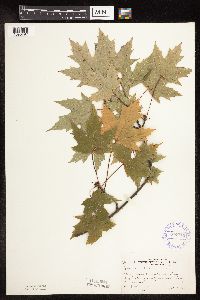 370715[1093797]Moore, John; et al. 137281940-10-01 United States, Minnesota, Isanti, E shore Green Lake, Wyanett Twp. Isanti County;;;;, 45.57909 -93.43323 |
MIN:Plants | 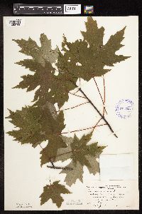 371523[1093799]Moore, John; et al. 149461941-08-07 United States, Minnesota, Kanabec, Snake River, 1/2 mi S of Mora, Kanabec Co.;;039N;24W;, 45.86068 -93.32753 |
MIN:Plants | 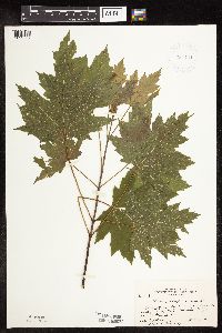 381444[1093787]Moore, John; et al. 154371942-06-20 United States, Minnesota, Dodge, Hwy 57, Zumbro River, 1 mi NE of Berne, Milton Twp;;108N;16W;, 44.15236 -92.73871 |
MIN:Plants | 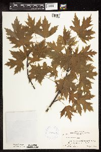 381559[1093838]Moore, John; Harden, P. 143161942-05-16 United States, Minnesota, Pine, Big Sand Creek, E of Hinckley, Pine Co.;;;;, 45.93417 -92.64 |
MIN:Plants |  381745[1093798]Moore, John; et al. 153141942-06-19 United States, Minnesota, Steele, Straight River bridge at N end of Medford, Medford Twp, NE1/4 S8;;108N;20W;08, 44.17506 -93.25668 |
MIN:Plants |  407288[1093810]Lakela, Olga 85801949-06-26 United States, Minnesota, Saint Louis, St. Louis Co.; White Iron Lake, E of Ely;Superior National Forest;062N;12W;, 47.84605 -91.86099 |
MIN:Plants |  407312[1093789]Lakela, Olga 95171949-08-28 United States, Minnesota, Saint Louis, St. Louis Co.; Lake Kabetogama near Park Point Resort;Voyageurs National Park;;;, 46.73167 -92.05556 |
MIN:Plants |  412152[1093782]Moore, John; et al. 112641939-07-28 United States, Minnesota, Lake of the Woods, Pine Creek 1/2 mi up from the mouth. Lake of the Woods County.;Northwest Angle;168N;34W;, 49.34462 -95.02889 |
MIN:Plants |  412888[1093755]Moore, John; et al. 119931939-08-22 United States, Minnesota, Lake of the Woods, mouth of Rapid River, Clementson. Lake of the Woods County;;160N;30W;, 48.66397 -94.49827 |
MIN:Plants |  419145[1093813]Ahlgren, Clifford 4751949-07-23 United States, Minnesota, Lake, Quetico-Superior Wilderness Research Center...Lake Co.; S9, T64N, R10W;Boundary Waters Canoe Area Wilderness / Superior National Forest;064N;10W;09, 48.03165 -91.61886 |
MIN:Plants |  419500[1093757]Lakela, Olga 116461950-08-23 United States, Minnesota, Saint Louis, St. Louis County...Iron Lake at the portage from Crooked Lake;Boundary Waters Canoe Area Wilderness / Superior National Forest;066N;12W;06, 48.23079 -91.91703 |
MIN:Plants |  419546[1093835]Lakela, Olga 115801950-08-21 United States, Minnesota, Saint Louis, Crooked Lake, near Curtain Falls;Boundary Waters Canoe Area Wilderness / Superior National Forest;060N;12W;, 47.67261 -91.86052 |
MIN:Plants |  420647[1093847]Lakela, Olga 120551950-09-06 United States, Minnesota, Saint Louis, Chisholm;;058N;20W;, 47.49867 -92.87046 |
MIN:Plants |  420697[1093837]Lakela, Olga 119191950-09-01 United States, Minnesota, Saint Louis, Floodwood River terrace, at Floodwood;;050N;20W;, 46.80928 -92.87068 |
MIN:Plants |  421667[1093784]Ahlgren, Clifford 11521950-08-22 United States, Minnesota, Saint Louis, bay 1/2 mi SW of Curtain Falls, Crooked Lake;Boundary Waters Canoe Area Wilderness / Superior National Forest;066N;12W;, 48.18679 -91.86997 |
MIN:Plants |  422638[1093845]Lakela, Olga 78691948-09-18 United States, Minnesota, Saint Louis, St. Louis County...St. Louis River near Floodwood;;051N;20W;, 46.89584 -92.86911 |
MIN:Plants |  429557[1093816]Smith, Welby 193681991-07-10 United States, Minnesota, Koochiching, Grand Mound Historical Site. Koochiching County...Grand Mound Historic Site, about 18 miles west of International Falls...floodplain of the River River...T 70N R 26W NW1/4 of NE1/4 of Sec 32. 070N 26W 32, 48.5158348 -93.7083359 |
MIN:Plants |  430668[1093817]Smith, Welby 192451991-07-08 United States, Minnesota, Koochiching, Franz Jevne State Park. Koochiching County...Franz Jevne State Park, in the Rainy River Valley, about 2 miles northeast of Birchdale... between the Rainy River and the adjacent alluvial forest...T 160N R 27W SW1/4 of SW1/4 of Sec 26. 160N 27W 26, 48.6427765 -94.078331 |
MIN:Plants |  439338[1093711]Smith, Welby 163591989-09-05 United States, Minnesota, Mille Lacs, Mille Lacs County ... About 11 miles north of Milaca; SW1/4 SE1/4 sec.26, T40N R27W;;040N;27W;26, 45.9249992 -93.6680527 |
MIN:Plants |  440753[1093774]Smith, Welby 149061988-08-17 United States, Minnesota, Meeker, Meeker County...About 3.5 mi W of Kingston...along the North Fork Crow River, near the Hwy 27 crossing...SW1/4 tc. NE1/4 sec.13, T120N R30W. 120N 30W 13, 45.2036095 -94.3880539 |
MIN:Plants |  441083[1093796]Nation, R. 94-2791994-07-18 United States, Minnesota, Mower, Lake Louise State Park. Mower Co.; Tract 1B; T101N R14W W1/2 SE1/4 of sec. 21;Lake Louise State Park;101N;14W;21, 43.53658 -92.51904 |
MIN:Plants |  445338[1093829]Boe, J.; et al. 950919021995-09-19 United States, Minnesota, Cass, Cass County...Ottertail Peninsula...T 143N R 30W NE1/4 of NE1/4 of Sec 11;Chippewa National Forest / Leech Lake Indian Reservation;143N;30W;11, 47.21448 -94.43535 |
MIN:Plants |  446403[1093833]Moore, John; Huff, N. 188301946-07-31 United States, Minnesota, Benton, Benton Co. Along Mayhew Creek, Mayhew Creek Valley NE of East St. Cloud;;;;, 45.58722 -94.04222 |
MIN:Plants |  446681[1093834]Moore, John; Huff, N. 178071945-07-23 United States, Minnesota, Morrison, Along the river at Little Falls;;;;, 45.97639 -94.36222 |
MIN:Plants |  448301[1093842]Moore, John; Huff, N. 189361946-08-02 United States, Minnesota, Benton, Benton Co. Along the banks of the Mississippi River at Sauk Rapids;;036N;31W;, 45.61114 -94.16239 |
MIN:Plants |  449120[1093803]Moore, John 169601945-05-30 United States, Minnesota, Watonwan, S fork of the Watonwan River, 5 mi E of St. James;;106N;31W;, 43.97858 -94.55427 |
MIN:Plants |  463400[1093764]Lakela, Olga 148721952-07-13 United States, Minnesota, Saint Louis, St. Louis Co.; Pine Island, Kabetogama Lake;Voyageurs National Park;070N;21W;, 48.5433 -93.02505 |
MIN:Plants |  463793[1093712]Smith, Welby 206291992-06-30 United States, Minnesota, Rice, About 6.5 miles north-northeast of Faribault ... on the floodplain of the Cannon River. NE1/4 of NE1/4 of Sec.;Cannon River Wilderness Park;110N;20W;04, 44.3708344 -93.223053 |
MIN:Plants |  466708[1093749]Schik, K. 95-1591995-08-29 United States, Minnesota, Yellow Medicine, Upper Sioux Agency State Park. Yellow Medicine Co.; T115N R38W SE1/4 of the NW1/4 of S28; at the edge of the Minnesota River at Upper Sioux Agency Stat Yellow Medicine Co.; T115N R38W SE1/4 of the NW1/4 of S28; at the edge of the Minnesota River at Upper Sioux Agency State Park. 115N 38W 28, 44.73556 -95.43358 |
MIN:Plants |  488517[1093742]Moore, John; Huff, N. 197541947-08-26 United States, Minnesota, Sibley, Minnesota River opposite Le Sueur;;112n;26W;, 44.50001 -93.949 |
MIN:Plants |  492921[1093765]Lakela, Olga 166891953-08-08 United States, Minnesota, Saint Louis, St. Louis Co.; Lac La Croix E of Lac La Croix Resort;Boundary Waters Canoe Area Wilderness / Superior National Forest;;;, 48.34361 -92.12278 |
MIN:Plants |  500763[1093770]Moore, John 205131950-05-26 United States, Minnesota, Freeborn, Along the N shore of Freeborn Lake at Freeborn;;;;, 43.76583 -93.56389 |
MIN:Plants |  505300[1093773]Schik, K. 95-1681985-08-31 United States, Minnesota, Le Sueur, Chamberlain Woods Scientific Natural Area. Le Sueur Co. T111N R26W SW1/4 of the SW1/4 of S22; 300 m from the edge of the Minnesota River at Chamberlain Woods Scien Le Sueur Co. T111N R26W SW1/4 of the SW1/4 of S22; 300 m from the edge of the Minnesota River at Chamberlain Woods Scientific and Natural Area.. 111N 26W 22, 44.40601 -93.93941 |
MIN:Plants |  507227[1093778]Moore, John 206631950-06-20 United States, Minnesota, Martin, Along the shore at the N end of Budd Lake at Fairmont;;;;, 43.64028 -94.46611 |
MIN:Plants |  515850[1093775]Myhre, K. 33691992-09-29 United States, Minnesota, Cass, Schoolcraft State Park. Cass Co.; Located between the campground and the group camp at Schoolcraft State Park; T 143N R 25W SW1/4 of SE1/4 of se Cass Co.; Located between the campground and the group camp at Schoolcraft State Park; T 143N R 25W SW1/4 of SE1/4 of sec 2. 143N 25W 2, 47.22967 -93.80645 |
MIN:Plants |  526086[1093821]Lakela, Olga 189561955-05-28 United States, Minnesota, Saint Louis, St. Louis Co.; Floodwood River bank, hwy 73, near Meadowlands Junction;;052N;20W;, 46.98261 -92.86869 |
MIN:Plants | 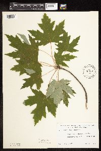 533066[1093792]Lakela, Olga 201821956-07-01 United States, Minnesota, Saint Louis, St. Louis Co.; south bank of Little Fork River, Hwy No. 5, at the bridge;;;;, 47.84081 -92.77542 |
MIN:Plants | 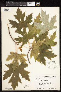 542721[1093785]Moore, John 216691952-06-03 United States, Minnesota, Brown, along creek, S17, Eden Twp;;;;, 44.42 -94.81528 |
MIN:Plants | 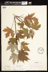 543037[1093795]Lakela, Olga 223151957-09-05 United States, Minnesota, Lake, Lake County...White Iron Lake at Silver Rapids;Superior National Forest;063N;11W;32, 47.8982 -91.76161 |
MIN:Plants | 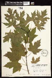 549968[1093788]Moore, John 220951954-09-15 United States, Minnesota, Sherburne, Mississippi River 3 mi SW of Clear Lake;;;;, 45.40098 -94.00847 |
MIN:Plants |  550221[1093780]Moore, John; et al. 222891954-09-22 United States, Minnesota, Lincoln, Lincoln County...1 mi S of Dead Coon Lake.;;;;, 44.34055 -96.09673 |
MIN:Plants |  553672[1093814]Mielke, Walter 651957-09-00 United States, Minnesota, Itasca, Local park and streets of Bovey;;;;, 47.29556 -93.41861 |
MIN:Plants |  554330[1093800]Moore, John 232841957-06-18 United States, Minnesota, Martin, 1/2 mi S of Dunnell;;;;, 43.53047 -94.77417 |
MIN:Plants |  558445[1093732]Moore, John; et al. 235481957-09-19 United States, Minnesota, Isanti, Old house site, Cedar Creek Forest; NW1/4 Sec. 16 Athens Twp.;Cedar Creek National History Area;034N;23W;16, 45.43572 -93.21482 |
MIN:Plants |  566651[1093841]Moore, John 239111958-06-14 United States, Minnesota, Kittson, Along the river at Hallock.;;161N;49W;, 48.76042 -96.99613 |
MIN:Plants |  572465[1093812]Moore, John 258311961-09-27 United States, Minnesota, Pipestone, Pipestone Co.; at Ruthton;;108N;44W;, 44.15331 -96.1241 |
MIN:Plants |  572719[1093779]Moore, John 253761961-06-06 United States, Minnesota, Houston, 2 mi W of Reno [most likely meant East];;;;, 43.6011 -91.31501 |
MIN:Plants |  583829[1093825]Gunderson, R. 21961-04-21 United States, Minnesota, Washington, Washington Co.; 2 mi N Stillwater on islands in the St. Croix River;;030N;20W;, 45.08498 -92.81735 |
MIN:Plants |  583874[1093766]Gunderson, R. 5041961-07-18 United States, Minnesota, Washington, Washington County ... St. Croix River, 3 mi N of Stillwater, N shore;Saint Croix National Riverway;030N;20W;, 45.08498 -92.81735 |
MIN:Plants |  590603[1093819]Lee, Michael MDL3121993-08-16 United States, Minnesota, Dakota, Dakota Co.; Lebanon Hills Regional Park, Jensen Lake; T 27N R 23W SW1/4 of SW1/4 of Sec 34;Lebanon Hills County Park;027N;23W;34, 44.7829 -93.15686 |
MIN:Plants |  592110[1093781]Moore, John 267061964-09-15 United States, Minnesota, Anoka, Near the house of the John Mickelson Farmsted, Cedar Creek Natural History Area;Cedar Creek National History Area;034N;23W;, 45.42806 -93.204 |
MIN:Plants |  603823[1093760]Moore, John; Dorn, Robert 270321967-05-26 United States, Minnesota, Wabasha, Along the Mississippi River bank; Greenfield Twp. Sec. 19 E;;110N;10W;19, 44.31557 -92.05942 |
MIN:Plants |  607248[1093824]Grafstrom, M. 931968-04-27 United States, Minnesota, Pine, Pine Co. T40N R18W NW1/4 Sec. 12;Saint Croix State Park;040N;18W;12, 45.97238 -92.54592 |
MIN:Plants |  670717[1093762]Heitlinger, M. 4541971-10-10 United States, Minnesota, McLeod, Schaefer Prairie, in NE portion of prairie; SE1/4 Sec. 34 T115N R29W;Schaefer Prairie, The Nature Conservancy;115N;29W;34, 44.72505 -94.30491 |
MIN:Plants |  681117[1093808]Swanson, Steven 9211975-06-25 United States, Minnesota, Houston, Mississippi River (Navigation Pool #8). Houston Co, Site 29;Upper Mississippi National Wildlife Refuge;;;, 43.68376 -91.29639 |
MIN:Plants |  681154[1093804]Swanson, Steven 4671975-06-13 United States, Minnesota, Houston, Mississippi River (Navigation Pool #8). Houston Co, Site 9, rr bank on W side of main channel;Upper Mississippi National Wildlife Refuge;;;, 43.70759 -91.27991 |
MIN:Plants |  681253[1093815]Swanson, Steven 8071975-06-23 United States, Minnesota, Houston, Mississippi River (Navigation Pool #8). Houston Co, Site 26, N tip of Pettibone island;Upper Mississippi National Wildlife Refuge;;;, 43.68376 -91.27991 |
MIN:Plants |  681301[1093806]Swanson, Steven 5261975-06-14 United States, Minnesota, Houston, Mississippi River (Navigation Pool #8). Houston Co, Site 11, rr bank on W side of main channel;Upper Mississippi National Wildlife Refuge;;;, 43.67185 -91.29089 |
MIN:Plants |  681415[1093802]Swanson, Steven 9941975-06-26 United States, Minnesota, Houston, Mississippi River (Navigation Pool #8). Houston Co, Site 37, delta of Root River;Upper Mississippi National Wildlife Refuge;;;, 43.76194 -91.25167 |
MIN:Plants |  681430[1093809]Swanson, Steven 9511975-06-25 United States, Minnesota, Houston, Mississippi River (Navigation Pool #8). Houston Co, Site 30, railroad levee;Upper Mississippi National Wildlife Refuge;;;, 43.67185 -91.2854 |
MIN:Plants |  681459[1093807]Swanson, Steven 8531975-06-23 United States, Minnesota, Houston, Mississippi River (Navigation Pool #8). Houston Co, Site 31;Upper Mississippi National Wildlife Refuge;;;, 43.67185 -91.29089 |
MIN:Plants |  681485[1093805]Swanson, Steven 5501975-06-16 United States, Minnesota, Houston, Mississippi River (Navigation Pool #8). Houston Co, Site 18, N end of forest;Upper Mississippi National Wildlife Refuge;;;, 43.67582 -91.29089 |
MIN:Plants |  685190[1093761]Stassen, Carol 651977-06-14 United States, Minnesota, Lyon, Camden State Park, N picnic grounds; T110N R42W Sec. 5;Camden State Park;110N;42W;5, 44.36318 -95.92744 |
MIN:Plants |  687586[1093776]Wheeler, Gerald; Glaser, Paul 20311977-07-12 United States, Minnesota, Itasca, Coll site no. 108; SE1/4 NW1/4 S26, T55N, R25W; ca 2 mi SE of Grand Rapids;;055N;25W;26, 47.21755 -93.48044 |
MIN:Plants | 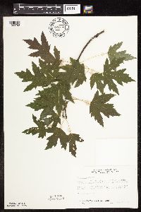 687826[1093783]Wheeler, Gerald; Glaser, Paul 22721977-07-26 United States, Minnesota, Itasca, coll. site no. 168; NE1/4 NW1/4 S4, T53N, R24W; ca 11 mi SSE of Grand Rapids; E side of Mississippi River;;053N;24W;4, 47.10478 -93.39317 |
MIN:Plants | 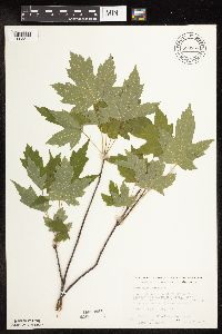 690868[1093844]Wheeler, Gerald 26501978-07-06 United States, Minnesota, Beltrami, adjacent to where Hwy 1 crosses the Blackduck River; ca 12 mi W of Shooks, T151N, R32W, S23;;151N;32W;23, 47.88254 -94.71055 |
MIN:Plants | 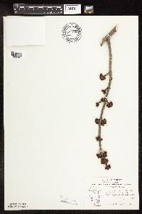 691052[1093828]Sperling, C. 11976-04-03 United States, Minnesota, Douglas, 2 1/2 mi W, 3 mi S of Holmes City;;;;, 45.79017 -95.58239 |
MIN:Plants | 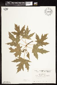 696748[1093801]Smith, Welby 8891978-06-11 United States, Minnesota, Wright, Wright Co. T122N, R25W, N1/2 S32, about 3 mi NW of Monticello, on bank of Mississippi River;;122N;25W;32, 45.33191 -93.86 |
MIN:Plants | 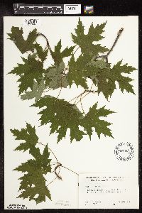 700481[1093848]Ownbey, Gerald 59891978-06-27 United States, Minnesota, Cass, Cass Co. T143N, R30W, W1/2 W1/2 S23; Otter Tail Point;Chippewa National Forest / Leech Lake Indian Reservation;143N;30W;23, 47.18591 -94.43511 |
MIN:Plants | 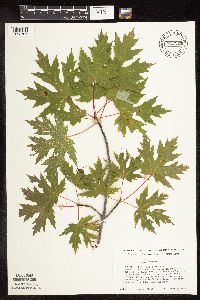 712123[1093767]Smith, Welby 18681979-09-02 United States, Minnesota, Wright, Wright Co. Between Crow River and co. hwy 19, 0.9 mi N of its jnc with st. 55 in Rockford, floodplain of Crow River; T11 Wright Co. Between Crow River and co. hwy 19, 0.9 mi N of its jnc with st. 55 in Rockford, floodplain of Crow River; T119N R24W SE1/4 Sec. 20. 119N 24W 20, 45.09608 -93.72842 |
MIN:Plants | 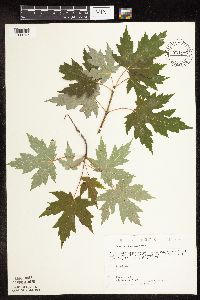 721175[1093763]Lustig, K. 8741979-07-11 United States, Minnesota, Sherburne, Sherburne Co. Clear Lake-Mississippi Scenic and Recreational River SNA, 12 mi SE of St. Cloud; Sec. 14, 22, 23 T34N R30W;Clear Lake Scientific Natural Area;034N;30W;, 45.44634 -94.04378 |
MIN:Plants | 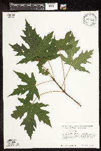 723795[1093733]Smith, Welby 36701980-09-08 United States, Minnesota, Wright, Wright Co. S bank of North Fork Crow River, 1/2 mi SW of jnc of st. hwy 25 and co. hwy 115; T119N R25 NE1/4 NE1/4 Sec. 3 Wright Co. S bank of North Fork Crow River, 1/2 mi SW of jnc of st. hwy 25 and co. hwy 115; T119N R25 NE1/4 NE1/4 Sec. 30. 119N 25W 30, 45.08652 -93.87987 |
MIN:Plants |  723799[1093836]Smith, Welby 36801980-09-09 United States, Minnesota, Wright, Wright Co. On E bank of North Fork Crow River at crossing of co. rd 3, ca. 1/2 mi S of French Lake; T120N R28W NE1/4 SW1 Wright Co. On E bank of North Fork Crow River at crossing of co. rd 3, ca. 1/2 mi S of French Lake; T120N R28W NE1/4 SW1/4 Sec. 22. 120N 28W 22, 45.18952 -94.18572 |
MIN:Plants |  723821[1093846]Smith, Welby 32541980-08-10 United States, Minnesota, Wright, Wright Co. About 2 mi E of St. Michael, on W bank of the Crow River; T120N R23W NW1/4 NW1/4 Sec. 18;;120N;23W;18, 45.20686 -93.63196 |
MIN:Plants |  723897[1093786]Smith, Welby 32901980-08-10 United States, Minnesota, Wright, Wright Co. On the N shore of Buffalo Lake, near the edge of the lake; T120N R26W SW1/4 NE1/4 Sec. 25;;120N;26W;25, 45.17256 -93.89992 |
MIN:Plants |  724097[1093734]Smith, Welby 29231980-07-20 United States, Minnesota, Wright, Wright Co. On W bank of the Mississippi River, about 1/2 mi W of Monticello; T121N R25W NE1/4 SE1/4 Sec. 3;;121N;25W;3, 45.31652 -93.81951 |
MIN:Plants |  727256[1093735]Smith, Welby 34891980-08-23 United States, Minnesota, Wright, Wright Co. On W bank of the Mississippi River, at its confluence with the Crow River, just W of Dayton; T121N R23W SE1/4 Wright Co. On W bank of the Mississippi River, at its confluence with the Crow River, just W of Dayton; T121N R23W SE1/4 NE1/4 Sec. 36. 121N 23W 36, 45.24467 -93.52105 |
MIN:Plants |  728719[1093823]Lustig, K. 3071979-05-31 United States, Minnesota, Sherburne, Mississippi River Islands Scientific Natural Area. Sherburne & Wright Cos. ...Mississippi Scenic and Recreational River Islands SNA, Mississippi River River Islands between Monticello and Elk River; sec. 2, 3, 4, T32N, R26, 27W; sec. 7, 9, 18, T121N R23, 24W. 032N 26W 3, 45.29348 -93.55625 |
MIN:Plants |  729060[1093737]Cutler, S. 551980-06-12 United States, Minnesota, Chisago, Chisago Co. Goose Creek Natural Area, 5 mi SE of Rush City; SW1/4 Sec. 19 T36N R20W;Wild River State Park;036N;20W;19, 45.59306 -92.89192 |
MIN:Plants |  729686[1093736]Converse, C. 1811980-06-06 United States, Minnesota, Pine, Pine Co. St. Croix Natural Area, 21 mi E of Hinckley; NW1/4 NW1/4 Sec. 5 T40N R17W;Saint Croix State Park;040N;17W;5, 45.98042 -92.49605 |
MIN:Plants |  730013[1093739]Converse, C. 1211980-06-04 United States, Minnesota, Pine, Pine Co. Kettle River Natural Area, 5.5 mi E of Hinckley; SE1/4 SW1/4 Sec. 23 T41N R20W;Kettle River Scientific Natural Area / Sandstone National Wildlife Refuge;041N;20W;23, 46.01861 -92.8358 |
MIN:Plants |  730168[1093726]Converse, C. 1101980-06-03 United States, Minnesota, Chisago, Rush Lake Island Natural Area, 7 mi WSW of Rush City; NE1/4 SW1/4 Sec. 21 T37N R22W;Rush Lake Island Scientific Natural Area;037N;22W;21, 45.6805 -93.09363 |
MIN:Plants |  747182[1093708]Galatowitsch, S. 8321982-09-15 United States, Minnesota, Wabasha, Wabasha County...Weaver Dunes: T109N, R09W, SE1/4 and E1/2 NE1/4 of Sec. 7; NW1/4 and W1/2 NE1/4 Sec. 8.;Kellogg-Weaver Dunes Scientific Natural Area / Kellogg-Weaver Dunes, The Nature Conservancy;109N;09W;00, 44.23311 -91.91725 |
MIN:Plants |  759041[1093740]Smith, Welby 69731982-07-30 United States, Minnesota, Mower, Brandt-Larson Wildlife Management Area. Mower Co.; Brandt-Larson State Wildlife Management Area, about 4 mi NE Lyle, along Otter Creek; NE1/4 SW1/4 Sec. 16 T 10 Mower Co.; Brandt-Larson State Wildlife Management Area, about 4 mi NE Lyle, along Otter Creek; NE1/4 SW1/4 Sec. 16 T 101N R 17W. 101N 17W 16, 43.55075 -92.87884 |
MIN:Plants |  766694[1093840]Haig, Vincent s.n.2000-09-12 United States, Minnesota, Blue Earth, Mankato;;;;, 44.16361 -93.99917 |
MIN:Plants |  772325[1093768]Boe, J. 17051980-07-16 United States, Minnesota, Lake of the Woods, Clementson. At the mouth of Rapid River. E1/2 Sec. 12, R30W, T160N.;;160N;30W;12, 48.6903 -94.43922 |
MIN:Plants |  772972[1093729]Boe, J. 17121980-07-22 United States, Minnesota, Lake of the Woods, Along South Fork of Rapid River;;157N;33W;14, 48.4172 -94.85246 |
MIN:Plants |  773886[1093730]Boe, J. 17111980-07-22 United States, Minnesota, Lake of the Woods, Along North Branch of Rapid River; Sec. 17 T158N R32W;;158N;32W;17, 48.50425 -94.78834 |
MIN:Plants |  774283[1093728]Monson, Paul 54181983-06-18 United States, Minnesota, Saint Louis, Voyageurs National Park, Lake Kabetogama, N shore, outcrop point, beach to W; T69N R20W SE1/4 Sec. 16;Voyageurs National Park;069N;20W;16, 48.46295 -92.90694 |
MIN:Plants |  781745[1093811]Smith, Welby 88971984-05-29 United States, Minnesota, Jackson, Kilen Woods State Park. Kilen Woods State Park, ca. 8 mi NNW of Jackson, bluff in the Des Moines River Valley, slope near the river; SW1/4 NE1/4 Kilen Woods State Park, ca. 8 mi NNW of Jackson, bluff in the Des Moines River Valley, slope near the river; SW1/4 NE1/4 Sec. 17 T103N R35W. 103N 35W 17, 43.72481 -95.06465 |
MIN:Plants |  782439[1093843]Tenney, M. 3411982-07-01 United States, Minnesota, Fillmore, Forestville State Park, Fillmore Co. T102N, 12W, 24N, S1/2 SE1/4 NW1/4;Forestville State Park;102N;12W;24, 43.62341 -92.21915 |
MIN:Plants |  787634[1093753]Smith, Welby 106841985-07-11 United States, Minnesota, Goodhue, On the banks of the Cannon River, ca. 2.5 mi E of Welch; SW1/4 SW1/4 Sec. 25 T113N R16W;;113N;16W;25, 44.56481 -92.68238 |
Google Map
Google Maps is a web mapping service provided by Google that features a map that users can pan (by dragging the mouse) and zoom (by using the mouse wheel). Collection points are displayed as colored markers that when clicked on, displays the full information for that collection. When multiple species are queried (separated by semi-colons), different colored markers denote each individual species.