University of Minnesota
http://www.umn.edu/
612-625-5000
http://www.umn.edu/
612-625-5000
Minnesota Biodiversity Atlas
Bell Museum
Dataset: MIN-Plants
Taxa: Sapindaceae
Search Criteria: excluding cultivated/captive occurrences
Bell Museum plants | |
 MIN:Plants | 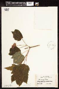 Acer spicatum Lamarck 442577[1094129]Lakela, Olga 131791951-07-13 United States, Minnesota, Saint Louis, Rainy Lake at Hilke's Point;Voyageurs National Park;;;, 48.625 -93 |
MIN:Plants | 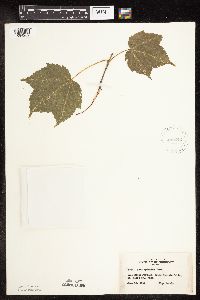 Acer spicatum Lamarck 442642[1094209]Lakela, Olga 123441951-06-18 United States, Minnesota, Saint Louis, St. Louis County...Iron River portage, below Curtain Falls;Boundary Waters Canoe Area Wilderness / Superior National Forest;066N;12W;06, 48.23079 -91.91703 |
MIN:Plants | 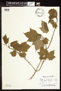 Acer spicatum Lamarck 445272[1094142]Myhre, K. 54301995-05-25 United States, Minnesota, Polk, Polk County...Located 2 miles southeast of the town of Lengby...T 147N R 39W SW1/4 of SW1/4 of sec 34;;147N;39W;34, 47.50699 -95.60622 |
MIN:Plants | 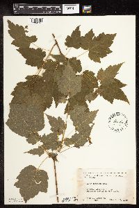 Acer spicatum Lamarck 445834[1094195]Moore, John; Huff, N. 179941945-07-25 United States, Minnesota, Morrison, Along r.r. right-of-way at Center Valley;;N;;, 45.9667 -94.3667 |
MIN:Plants |  Acer spicatum Lamarck 446505[1094042]Moore, John; Huff, N. 185371946-06-10 United States, Minnesota, Kanabec, Kanabec Co. 3 mi N of Mora;;040N;24W;, 45.94292 -93.32785 |
MIN:Plants |  Acer spicatum Lamarck 456894[1094024]Myhre, K. 48551994-05-27 United States, Minnesota, Itasca, Itasca Co.; located on the island in Rice Lake; T 148N R 27W NW1/4 of SW1/4 of Sec 1;Chippewa National Forest / Leech Lake Indian Reservation;148N;27W;1, 47.66524 -94.0464 |
MIN:Plants |  Acer spicatum Lamarck 457879[1094196]Garrison, O. 961880-07-30 United States, Minnesota, Upper Mississippi;;;;, 47.2181 -95.2072 |
MIN:Plants |  Acer spicatum Lamarck 459171[1094122]Smith, Welby 130081987-06-18 United States, Minnesota, Pine, Pine County ... in the St. Croix River Valley, about 7 miles SE of Pine City ... about 70 feet above the floodplain SW1/4 NE1/4 sec.21, T38N R20W. 038N 20W 21, 45.7666664 -92.8475037 |
MIN:Plants |  Acer spicatum Lamarck 459239[1094116]Lee, Michael MDL4311994-05-16 United States, Minnesota, Fillmore, Fillmore Co.; Shattuck Creek 2.5 mi SE of Highland; T102N R8W NE1/4 of NW1/4 of Sec 8;Dorer Memorial Hardwood State Forest;102N;08W;8, 43.65233 -91.81971 |
MIN:Plants |  Acer spicatum Lamarck 462515[1094080]Lakela, Olga 158111952-00-00 United States, Minnesota, Saint Louis, Sand Point Lake, W of Harrison's Narrows.;Voyageurs National Park;;;, 48.4 -92.45833 |
MIN:Plants |  Acer spicatum Lamarck 462617[1094054]Lakela, Olga 153581952-08-02 United States, Minnesota, Saint Louis, Isle of Pines, Vermilion Lake;;062N;16W;10, 47.86623 -92.36178 |
MIN:Plants |  Acer spicatum Lamarck 462774[1094079]Lakela, Olga 148341952-07-10 United States, Minnesota, Saint Louis, An island in Rainy Lake, next to Dryweed Island, NW corner of the county;Voyageurs National Park;;;, 48.617646 -93.085847 |
MIN:Plants | 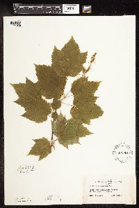 Acer spicatum Lamarck 462981[1094036]Lakela, Olga 141491952-06-17 United States, Minnesota, Saint Louis, Namakan Narrows;Voyageurs National Park;069N;17W;, 48.42824 -92.52702 |
MIN:Plants | 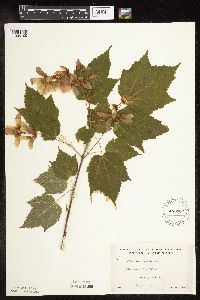 Acer spicatum Lamarck 463387[1094109]Lakela, Olga 149091952-07-13 United States, Minnesota, Saint Louis, Pine Island, Kabetogama Lake;Voyageurs National Park;069N;21W;, 48.45696 -93.02675 |
MIN:Plants | 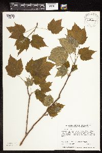 Acer spicatum Lamarck 464636[1094115]Harris, Fred 940221994-05-17 United States, Minnesota, Olmsted, Olmsted Co.; dolomite cliff along south side of Root river valley; SE1/4 of NE1/4 of SW1/4 Sect. 18 T105N R12W;Dorer Memorial Hardwood State Forest;105N;12W;18, 43.89855 -92.30845 |
MIN:Plants | 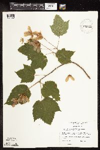 Acer spicatum Lamarck 475720[1094023]DeMink, L. 0011999-07-21 United States, Minnesota, Clearwater, Itasca State Park. Clearwater Co, Itasca State Park, Beaver Lake area T143N, R36W, SW 1/4 of NW 1/4 of S17. SW corner of Beaver Lake, 100 Clearwater Co, Itasca State Park, Beaver Lake area T143N, R36W, SW 1/4 of NW 1/4 of S17. SW corner of Beaver Lake, 100 ft. from Wilderness dRive, 75 ft. from lake near the bottom of a small hill.. 143N 36W 17, 47.20254 -95.2656 |
MIN:Plants |  Acer spicatum Lamarck 475723[1094022]Locke, M. 41999-07-29 United States, Minnesota, Clearwater, Clearwater Co, Itasca State Park, west side of Bud [sic] Lake, T143N R36W sec 36;Itasca State Park;143N;36W;36, 47.15985 -95.17988 |
MIN:Plants |  Acer spicatum Lamarck 475734[1094030]Roblek, K. 171996-06-23 United States, Minnesota, Clearwater, Clearwater County...Itasca State Park. Wilderness drive near Itasca's largest red pine.;Itasca State Park;143N;36W;16, 47.20267 -95.24436 |
MIN:Plants |  Acer spicatum Lamarck 481178[1094191]Lakela, Olga 159961953-06-08 United States, Minnesota, Saint Louis, Shorewoods of Vermilion Lake, Treasure Island Resort;;063N;18W;26, 47.9115 -92.60022 |
MIN:Plants |  Acer spicatum Lamarck 492947[1094206]Lakela, Olga 167001953-08-08 United States, Minnesota, Saint Louis, St. Louis Co.; Lac La Croix E of the Resort;Boundary Waters Canoe Area Wilderness / Superior National Forest;;;, 48.34361 -92.12278 |
MIN:Plants |  Acer spicatum Lamarck 504939[1094025]Smith, Welby 191951991-07-08 United States, Minnesota, Koochiching, Franz Jevne State Park. Koochiching County...Franz Jevne State Park, in the Rainy River Valley, about 2 mi NE of Birchdale... T160N R27W Sw1/4 of SW1/4 of Sec 26. 160N 27W 26, 48.6427765 -94.078331 |
MIN:Plants |  Acer spicatum Lamarck 508421[1094082]Lee, Michael MDL9331995-05-24 United States, Minnesota, Wabasha, Wabasha Co.; 420ft N-facing slope along the Mississippi River 1/2 mi W of Minneiska; T109N R9W NESW 34;Dorer Memorial Hardwood State Forest;109N;09W;34, 44.19973 -91.881 |
MIN:Plants |  Acer spicatum Lamarck 515453[1094028]Sather, Nancy s.n.1995-08-08 United States, Minnesota, Mahnomen, Mahnomen County...east of County Road 4 on northwest shore of South Twin Lake...T144 R39 NESW of Sec 32;White Earth Indian Reservation;144N;39W;32, 47.24412 -95.64772 |
MIN:Plants |  Acer spicatum Lamarck 518940[1094074]Smith, Welby 131051987-06-24 United States, Minnesota, Pine, Saint Croix State Park. Pine County ... St. Croix State Park; about 70 feet above the floodplain of the St. Croix River ... NE1/4 SW1/4 sec.31, T 41N R 17W. 041N 17W 31, 45.9897232 -92.5436096 |
MIN:Plants |  Acer spicatum Lamarck 519284[1094198]Monson, Paul 59431984-06-06 United States, Minnesota, Cook, Grand Portage National Monument; Cook Co.; R-5E, T-64N, S-25, Ca. 4 mi. NW of Visitor Center.;Grand Portage National Monument / North Shore;064N;05E;25, 47.99814 -89.74828 |
MIN:Plants |  Acer spicatum Lamarck 526138[1094067]Lakela, Olga 190971955-08-04 United States, Minnesota, Saint Louis, Road to Gold Mine Camp, Vermilion River forest, S of Crane Lake;;;;, 48.24022 -92.58419 |
MIN:Plants |  Acer spicatum Lamarck 527490[1094121]Lakela, Olga 179651954-07-24 United States, Minnesota, Saint Louis, St. Louis County...portage from Fairy Lake to Gun Lake, Superior National Forest, north of Ely;Boundary Waters Canoe Area Wilderness / Superior National Forest;065N;12W;14, 48.11477 -91.83202 |
MIN:Plants |  Acer spicatum Lamarck 532318[1094068]Lakela, Olga; et al. 204741956-07-14 United States, Minnesota, Lake, Lake County...West of Four-mile portage to Basswood Lake;Boundary Waters Canoe Area Wilderness / Superior National Forest;064N;11W;00, 48.01859 -91.73418 |
MIN:Plants |  Acer spicatum Lamarck 532464[1094170]Lakela, Olga 199161956-06-19 United States, Minnesota, Saint Louis, St. Louis River woods, S of the bridge, Ox-Bow Road W of Zim;;;;, 47.30903 -92.67174 |
MIN:Plants |  Acer spicatum Lamarck 532567[1094044]Lakela, Olga 197851956-06-16 United States, Minnesota, Saint Louis, Seven Beaver Bay, on the point facing the narrows;Superior National Forest;;;, 47.574369 -92.298787 |
MIN:Plants |  Acer spicatum Lamarck 532827[1094055]Lakela, Olga 203831956-07-10 United States, Minnesota, Saint Louis, Shore of Island Lake on Hwy. 73, S of Hibbing.;;055N;21W;, 47.23942 -93.00201 |
MIN:Plants |  Acer spicatum Lamarck 533067[1094164]Lakela, Olga 201881956-07-01 United States, Minnesota, Saint Louis, Little Fork River S of the bridge, Hwy No. 5;;;;, 48.12943 -92.87842 |
MIN:Plants | 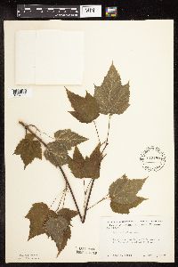 Acer spicatum Lamarck 542480[1094203]Moore, John 215821952-05-21 United States, Minnesota, Koochiching, Koochiching Co.; 1 mile south west of Northome;;151N;29W;, 47.88944 -94.35371 |
MIN:Plants | 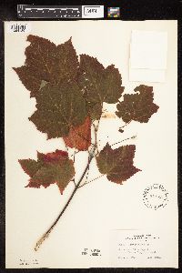 Acer spicatum Lamarck 543613[1094185]Lakela, Olga 225531957-09-22 United States, Minnesota, Lake, Lake Superior, SW of Beaver Bay;North Shore;055N;08W;15, 47.24932 -91.3358 |
MIN:Plants | 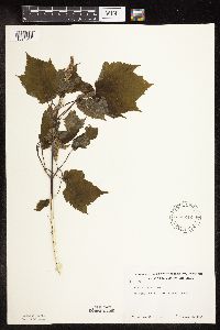 Acer spicatum Lamarck 583242[1094041]Kellner, H. 3761956-06-18 United States, Minnesota, Cook, Atop Mt. Maude, near Mineral Center;Grand Portage Indian Reservation / North Shore;063N;05E;1, 47.96877 -89.74823 |
MIN:Plants | 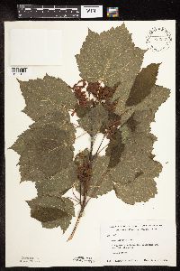 Acer spicatum Lamarck 583243[1094124]Kellner, H. 4661956-07-19 United States, Minnesota, Cook, Cook County...Along roadside below Mt. Josephine and near Lake Superior, Grand Portage.;Grand Portage Indian Reservation / North Shore;063N;06E;03, 47.9709 -89.662 |
MIN:Plants | 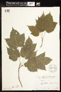 Acer spicatum Lamarck 590104[1094200]Meierotto, R. s.n.1962-07-28 United States, Minnesota, Becker, Becker Co. S5, T142N, R36W;Itasca State Park;142N;36W;5, 47.14493 -95.26537 |
MIN:Plants | 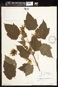 Acer spicatum Lamarck 590230[1094108]Voss, E. 100591961-07-16 United States, Minnesota, Lake, near S end of Cloquet Lake, S9-16, T57N, R9W, ca 14 mi W of Finland;Superior National Forest;057N;09W;09, 47.4371 -91.48128 |
MIN:Plants | 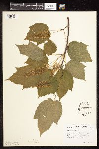 Acer spicatum Lamarck 594192[1094177]Thorne, Robert 303191962-06-11 United States, Minnesota, Clearwater, S of Campus of Univ of Minnesota Biol Sta, Itasca State Park;Itasca State Park;143N;36W;, 47.19557 -95.23322 |
MIN:Plants | 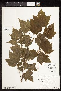 Acer spicatum Lamarck 616559[1094181]Moore, John; et al. 981969-06-03 United States, Minnesota, Crow Wing, Crow Wing Natural History Area. Crow Wing County...E of Chandler Lake, SW1/4 S22, Garrison Twp.;Crow Wing Natural Area;044N;28W;22, 46.27899 -93.86334 |
MIN:Plants | 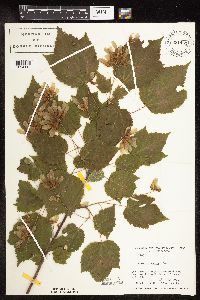 Acer spicatum Lamarck 631451[1094112]Richards, Donald; et al. 17451971-07-18 United States, Minnesota, Itasca, near woods on N shore of Deer Lake, 18 mi NW of Grand Rapids;;;;, 47.39167 -93.71333, 404m |
MIN:Plants | 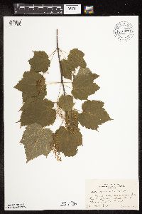 Acer spicatum Lamarck 676597[1094088]Gordon, William s.n.1939-06-19 United States, Minnesota, Clearwater, Bear Point, Itasca State Park;Itasca State Park;143N;36W;, 47.19557 -95.23322 |
MIN:Plants | 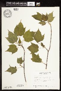 Acer spicatum Lamarck 686853[1094199]Wheeler, Gerald; Glaser, Paul 12791977-05-15 United States, Minnesota, Itasca, Site 6. NW1/4 SW1/4 Sec. 32, T55N, R26W; ca. 6 mi. SW of Grand Rapids.;;055N;26W;32, 47.20343 -93.6714 |
MIN:Plants | 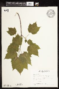 Acer spicatum Lamarck 686895[1094169]Wheeler, Gerald; Glaser, Paul 13211977-05-15 United States, Minnesota, Itasca, Site 9. NW1/4 NW1/4 Sec. 21, T55N, R26W; ca. 5 mi. W of Grand Rapids.;;055N;26W;21, 47.23238 -93.64948 |
MIN:Plants | 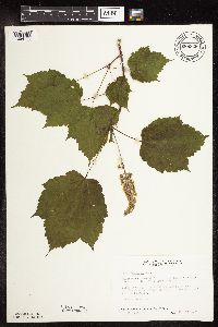 Acer spicatum Lamarck 686928[1094171]Wheeler, Gerald 13541977-05-21 United States, Minnesota, Itasca, Site 13. NE1/4 SW1/4 Sec. 1, T55N, R27W; ca. 8 mi. NW of Grand Rapids.;;055N;27W;1, 47.27517 -93.7133 |
MIN:Plants | 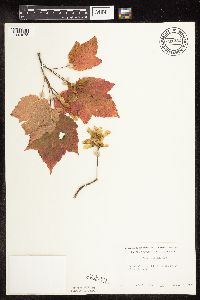 Acer spicatum Lamarck 691232[1094075]Lightfoot, J. s.n.1977-09-10 United States, Minnesota, Cook, Cook Co. NW1/4 of the NE1/4 of Sec. 32, T60N, R4W;North Shore / Superior National Forest;060N;04W;32, 47.63767 -90.86305 |
MIN:Plants | 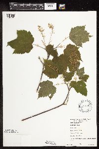 Acer spicatum Lamarck 698979[1094086]Sather, Nancy; et al. 771976-06-10 United States, Minnesota, Lake, Lake Co, NW1/4 Sec. 9, T60N, R11W.;Superior National Forest;060N;11W;09, 47.69847 -91.72883 |
MIN:Plants | 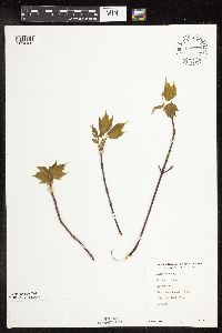 Acer spicatum Lamarck 698980[1094186]Sather, Nancy; et al. 161976-05-20 United States, Minnesota, Lake, Lake Co. Kawishiwi Field Lab. SW1/4 Sec. 34, T62N, R11W.;Superior National Forest;062N;11W;34, 47.81245 -91.71468 |
MIN:Plants | 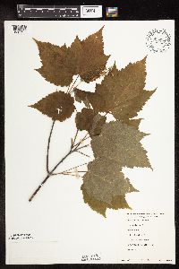 Acer spicatum Lamarck 698982[1094106]Sather, Nancy; et al. 3801977-06-14 United States, Minnesota, Lake, Lake Co, NW1/4 NE1/4 Sec. 35, T61N, R10W.;Superior National Forest;061N;10W;35, 47.72643 -91.56561 |
MIN:Plants | 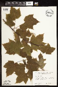 Acer spicatum Lamarck 700448[1094046]Ownbey, Gerald 58991978-06-16 United States, Minnesota, Cass, Cass Co. T143N, R30W, Sec. 1, NE1/4. Sucker Bay Rd. 10.3 mi. S of it's jct. with Rte. 2.;Chippewa National Forest / Leech Lake Indian Reservation;143N;30W;1, 47.22946 -94.41434 |
MIN:Plants | 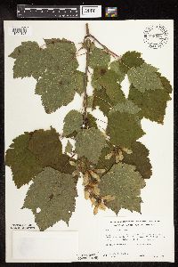 Acer spicatum Lamarck 708318[1094107]Ownbey, Gerald 63721979-08-11 United States, Minnesota, Houston, Dorer Memorial Hardwood State Forest. T103N, R6W, Sec. 27, SW1/4. Sheldon Twp. Minn. Mem. Hardw. St. For. Rte. 76, 5.5 mi. S of its jct. with Hwy. 16, 1 mi T103N, R6W, Sec. 27, SW1/4. Sheldon Twp. Minn. Mem. Hardw. St. For. Rte. 76, 5.5 mi. S of its jct. with Hwy. 16, 1 mi. E of Houston. Bluffs of Badger Creek.. 103N 06W 27, 43.6959 -91.54137 |
MIN:Plants | 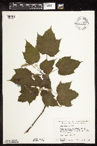 Acer spicatum Lamarck 708742[1094172]Wheeler, Gerald 37291979-06-08 United States, Minnesota, Pine, Pine Co. Approx. 2.25 mi W of Askov on Hwy. 23. On the W bank of the Kettle River. T43N, R20W, Sec. 23.;Banning State Park;043N;20W;23, 46.19413 -92.83499 |
MIN:Plants | 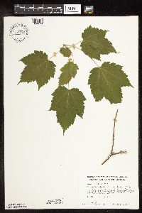 Acer spicatum Lamarck 709212[1094204]Wheeler, Gerald 42031979-07-05 United States, Minnesota, Houston, Ca. 9 mi. SW of Reno. On a wooded bluff overlooking Winnebago Creek. The woods ca, 0.25 mi. from Rte. 5. T101N, R5W, Ca. 9 mi. SW of Reno. On a wooded bluff overlooking Winnebago Creek. The woods ca, 0.25 mi. from Rte. 5. T101N, R5W, Sec. 15.. 101N 05W 15, 43.55136 -91.42203 |
MIN:Plants | 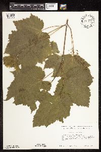 Acer spicatum Lamarck 711413[1094045]Smith, Welby 9891979-06-13 United States, Minnesota, Winona, Winona Co. T106N, R05W; NE1/4 NE1/4 Sec. 27. O.L. Kipp State Park. In woods at N side of Queen's Bluff.;Great River Bluffs State Park;106N;05W;27, 43.95529 -91.41082 |
MIN:Plants | 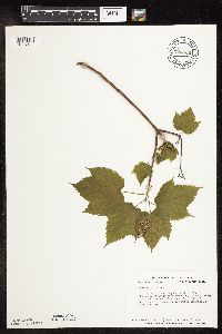 Acer spicatum Lamarck 724866[1094182]Smith, Welby 22681980-05-28 United States, Minnesota, Houston, Houston Co. T103N, R6W, SW1/4 SE1/4 SW1/4 Sec. 27. Ca. 200 ft, S of Hwy. 76, between Badger Creek and the top of a N-f Houston Co. T103N, R6W, SW1/4 SE1/4 SW1/4 Sec. 27. Ca. 200 ft, S of Hwy. 76, between Badger Creek and the top of a N-facing bluff.. 103N 06W 27, 43.6959 -91.54137 |
MIN:Plants | 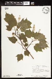 Acer spicatum Lamarck 727280[1094173]Smith, Welby 24651980-06-12 United States, Minnesota, Saint Louis, T51N, R18W, NW1/4 SW1/4 Sec. 4. On the N side of Co. Rd. 8, ca. 13 mi. due E of Floodwood.;;051N;18W;4, 46.9342 -92.62841 |
MIN:Plants | 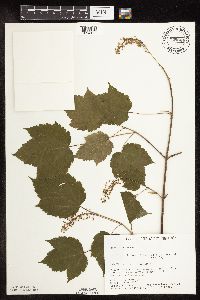 Acer spicatum Lamarck 729629[1094150]Converse, C. 1771980-06-06 United States, Minnesota, Pine, 21 mi E of Hinckley. NW1/4 NW1/4 Sec.;Saint Croix State Park;040N;17W;5, 45.98042 -92.49605 |
MIN:Plants | 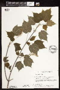 Acer spicatum Lamarck 729858[1094147]Converse, C. 1871980-06-05 United States, Minnesota, Pine, 5.5 mi E of Hinckley. SW1/4 NW1/4 of section;Kettle River Scientific Natural Area / Sandstone National Wildlife Refuge;041N;20W;23, 46.01861 -92.8358 |
MIN:Plants | 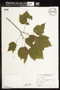 Acer spicatum Lamarck 749207[1094095]Wheeler, Gerald 55171981-05-30 United States, Minnesota, Pine, Banning State Park. Pine Co.; E-facing wooded slope adjacent to the Kettle River (W bank of the River and S of Rt. 123). T42N, R20W, Sec. 15 Pine Co.; E-facing wooded slope adjacent to the Kettle River (W bank of the River and S of Rt. 123). T42N, R20W, Sec. 15.. 042N 20W 15, 46.12157 -92.85579 |
MIN:Plants | 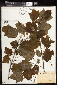 Acer spicatum Lamarck 763341[1094091]Gilbert, H. 1731923-06-08 United States, Minnesota, Saint Louis, Duluth;;N;;, 46.78333 -92.10639 |
MIN:Plants | 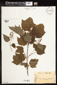 Acer spicatum Lamarck 763544[1094092]Lugger, O. s.n.1900-06-23 United States, Minnesota, Saint Louis, Lake Vermilion;;;;, 47.8579 -92.2996 |
MIN:Plants | 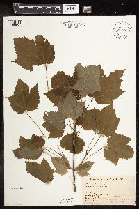 Acer spicatum Lamarck 763962[1094093]Lugger, O. s.n.1900-06-23 United States, Minnesota, Saint Louis, Lake Vermilion;;;;, 47.8579 -92.2996 |
MIN:Plants | 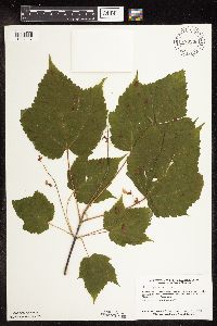 Acer spicatum Lamarck 770206[1094207]Smith, Welby 85361983-08-01 United States, Minnesota, Carlton, Hemlock Ravine State Scientific and Natural Area, ca. 2.5 mi. S of Esko. NW1/4 SE1/4 Sec. 3, T48N, R16W.;Hemlock Ravine Scientific Natural Area;048N;16W;3, 46.67056 -92.35393 |
MIN:Plants | 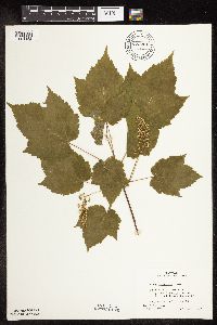 Acer spicatum Lamarck 772281[1094152]Boe, J. 3361979-06-22 United States, Minnesota, Lake of the Woods, Near Hwy. 1, N of Carp. On bank of the Baudette River, NW1/4 of sec.;;159N;31W;4, 48.62055 -94.63724 |
MIN:Plants |  Acer spicatum Lamarck 773765[1094090]Boe, J. 5701979-07-05 United States, Minnesota, Lake of the Woods, Near old Forestry House NE of Norris Camp. Sec. 4, R35W, T159N.;;159N;35W;4, 48.61971 -95.1592 |
MIN:Plants |  Acer spicatum Lamarck 774175[1094145]Monson, Paul 53341983-06-16 United States, Minnesota, Saint Louis, Voyageurs National Park. R21W, T70N, Sec. 34. Kabetogama Peninsula E of Camel Back Island.;Voyageurs National Park;070N;21W;34, 48.50713 -93.01521 |
MIN:Plants |  Acer spicatum Lamarck 795609[1094205]Wheeler, Gerald 62971982-08-10 United States, Minnesota, Mahnomen, Mahnomen Co.; at the jct. of Rt. 15 and Rt. 24. T146N, R39W, Sec. 3-4.;White Earth Indian Reservation;146N;39W;, 47.45525 -95.61444 |
MIN:Plants |  Acer spicatum Lamarck 824296[1094188]Marion, J. s.n.1982-00-00 United States, Minnesota, Cook, Cook Co, North Shore of Lake Superior, ca. 200 ft. from lakeshore.;North Shore;;;, 47.46396 -91.02551 |
MIN:Plants | 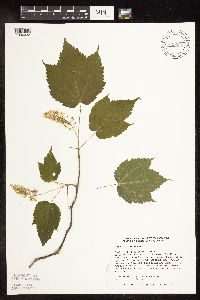 Acer spicatum Lamarck 829991[1094032]Townsend, D. 91-0301991-06-02 United States, Minnesota, Roseau, Roseau Co. Bemis Hill #1 Snowmobile Trail. Trail leading 290 deg. from N, base of hill below campground; SW1/4 SE1/4 Sec Roseau Co. Bemis Hill #1 Snowmobile Trail. Trail leading 290 deg. from N, base of hill below campground; SW1/4 SE1/4 Sec 31 T160N R37W. 160N 37W 31, 48.63422 -95.4623 |
MIN:Plants | 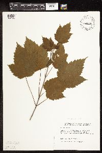 Acer spicatum Lamarck 830123[1094026]Wennerstrand, R. 141992-07-05 United States, Minnesota, Roseau, Roseau Co.; SW1/4 SW1/4 Sec 32 T161N R37W;Beltrami Island State Forest;161N;37W;32, 48.71996 -95.45064 |
MIN:Plants | 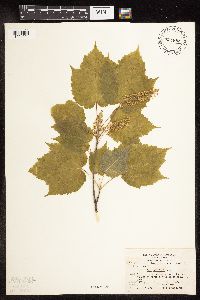 Acer spicatum Lamarck 831882[1094094]Gerhardt, F. s.n.1981-06-14 United States, Minnesota, Saint Louis, St. Louis Co.; above Low Lake. Elevation: 1380 ft. R-12W T-63N Sec.2;Superior National Forest;063N;12W;2, 47.9692 -91.83165 |
MIN:Plants | 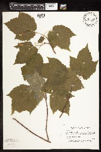 Acer spicatum Lamarck 832274[1094027]Myhre, K. 21381992-06-08 United States, Minnesota, Cass, Cass Co. Located 1.2 mi S of Moose Lake; T136N R31W SE1/4 of SE1/4 of Sec 21;;136N;31W;21, 46.57961 -94.59346 |
MIN:Plants | 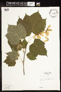 Acer spicatum Lamarck 835419[1094118]Monson, Paul 50321974-08-06 United States, Minnesota, Itasca, Itasca Co. R-26W, T-59N, S-4; E of Ethel Lake;Chippewa National Forest;059N;26W;04, 47.62391 -93.65112 |
MIN:Plants | 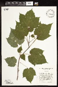 Acer spicatum Lamarck 836318[1094021]Cholewa, A. 24101995-08-10 United States, Minnesota, Aitkin, Savanna Portage State Park. Aitkin Co. Savanna Portage State Park, about 17 mi NE of McGregor, just downslope of snowmobile trail at SE end of ridge Aitkin Co. Savanna Portage State Park, about 17 mi NE of McGregor, just downslope of snowmobile trail at SE end of ridge NE of Savanna Lake, T51N R22W S31 SW1/4 of SW1/4.. 051N 22W 31, 46.86042 -93.17706 |
MIN:Plants | 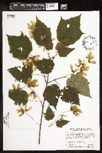 Acer spicatum Lamarck 459531[1094050]Smith, Welby 273251998-07-09 United States, Minnesota, Becker, Becker County...Smokey Hills State Forest, about 4 miles W-SW of Osage...T 140N R 37W SE1/4 of NW1/4 of Sec 35;Smokey Hills State Forest;140N;37W;35, 46.8994444 -95.3202778 |
MIN:Plants | 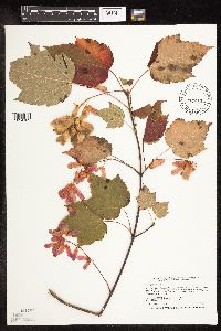 Acer spicatum Lamarck 429253[1094162]Smith, Welby 254641994-09-08 United States, Minnesota, Beltrami, At the Waskish Municipal Campground. SE1/4 of NE1/4 of sec;;154N;30W;08, 48.1722222 -94.5116667 |
MIN:Plants |  Acer spicatum Lamarck 493554[1094159]Smith, Welby 279431999-06-29 United States, Minnesota, Pine, about 3 miles SW of Askov. NE1/4 of SW1/4 of Sec;Banning State Park;043N;20W;35, 46.1630554 -92.8383331 |
MIN:Plants |  Acer spicatum Lamarck 428895[1094031]Myhre, K. 53871995-05-18 United States, Minnesota, Polk, Polk Co.; Located 6 miles northeast of the town of Fosston; T 148n R 39w SW1/4 of SE1/4 of Sec 34;Hagen Wildlife Management Area;148n;39W;34, 47.5935 -95.60704 |
MIN:Plants |  Acer spicatum Lamarck 476891[1094063]Smith, Welby 287262000-07-12 United States, Minnesota, Mille Lacs, Mille Lacs Kathio State Park. Mille Lacs County ... Mille Lacs Kathio State Park, about 8 miles northwest of Onamia ... T 42N R 27W SW1/4 of SE1/4 of Sec 5. 042N 27W 5, 46.1286125 -93.7724991 |
MIN:Plants |  Acer spicatum Lamarck 914538[1094051]Smith, Welby 251011994-08-16 United States, Minnesota, Itasca, Scenic State Park. Itasca County...In Scenic State Park; about 9 miles south-southeast of Effie...T 60N R 25W SW1/4 of SW 1/4 of Sec 6. 60N 25W 6, 47.7027778 -93.5733333 |
MIN:Plants | 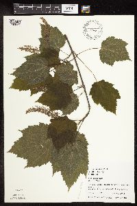 Acer spicatum Lamarck 461943[1094029]Juhnke, C. 240 CMJ FRO1999-05-18 United States, Minnesota, Goodhue, Frontenac State Park Goodhue County ... below east end of campground ... T112N R13W NW NW NW 2;Frontenac State Park;112N;13W;02, 44.53507 -92.33916 |
MIN:Plants | 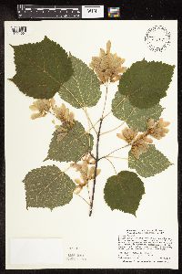 Acer spicatum Lamarck 429325[1094064]Smith, Welby 288302000-07-26 United States, Minnesota, Aitkin, Aitkin County ... Savanna Portage State Park; about one mile west of Shumway Lake ...T50N R22W SW1/4 of SE1/4 of Sec 7;Savanna Portage State Park;050N;22W;07, 46.8286095 -93.1744461 |
MIN:Plants | 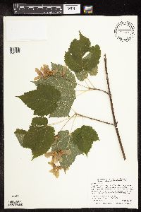 Acer spicatum Lamarck 509659[1094114]Smith, Welby 288672000-08-01 United States, Minnesota, Carlton, Carlton County ... Along the Willard Munger State Trail, about 1/4 mile east of Carlton (town) ... T 48N R 16W NW1/4 of NE1/4 of Sec 7. 048N 16W 7, 46.6622222 -92.4161111 |
MIN:Plants | 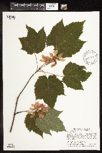 Acer spicatum Lamarck 915921[1094149]Smith, Welby; et al. 313972009-08-27 United States, Minnesota, Cook, Boundary Waters Canoe Area Wilderness / Superior National Forest. Cook County...Boundary Waters Canoe Area Wilderness, Superior National Forest. At the east end of Winchell Lake... T 64N R 2W SE1/4 of SE1/4 of Sec 26. 064N 02W 26, 47.9936111 -90.5369444 |
MIN:Plants |  Acer spicatum Lamarck 429232[1094117]Smith, Welby 271941998-06-03 United States, Minnesota, Cook, Cook County ... Temperance River State Park, abut 2 miles southwest of Tofte ... T 59N R 4W NW1/4 of NW1/4 of Sec 32;North Shore / Temperance River State Park;059N;04W;32, 47.5569458 -90.8713913 |
MIN:Plants |  Acer spicatum Lamarck 483668[1094060]Kaul, R.; et al. 69771991-06-24 United States, Minnesota, Cook, Cook County...Near the mouth of the Onion River gorge, Lutsen, where it opens to Lake Superior.;North Shore / Superior National Forest;059N;04W;, 47.59936 -90.84419 |
MIN:Plants |  Acer spicatum Lamarck 477490[1094146]Lee, Michael MDL11861996-05-28 United States, Minnesota, Winona, Winona County ... three miles north of Rushford ... T105N R8W NW1/4 SW1/4 Sec. 26;Dorer Memorial Hardwood State Forest;T105N R08W S26, 43.868387 -91.749752 |
MIN:Plants |  Acer spicatum Lamarck 483655[1094059]Kaul, R. 6584A1989-07-07 United States, Minnesota, Clearwater, Clearwater Co.; north boundary road of Itasca Park;Itasca State Park;143N;36W;, 47.19557 -95.23322 |
MIN:Plants | 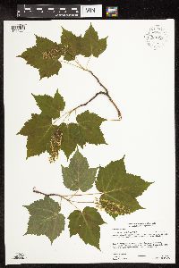 Acer spicatum Lamarck 930700[1094084]Gerdes, Lynden B. 60112010-06-15 United States, Minnesota, Cook, Brule Lake Trail area. Approximately 1.06 miles east of the Brule Lake Tower and 0.33 miles south of the hiking trail. NENWNWNW of section;Superior National Forest;063N;02W;29, 47.918611 -90.617222 |
MIN:Plants | 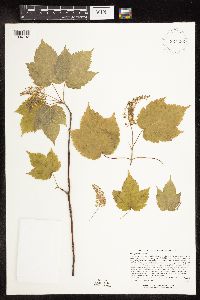 Acer spicatum Lamarck 924482[1094132]Lee, Michael MDL33682003-06-03 United States, Minnesota, Todd, Upper reaches of Swan River, 7 miles SW of Cushing, 10 miles E-SE of Browerville. NW1/4 of section;;130N;32W;24, 46.05692 -94.65825 |
MIN:Plants | 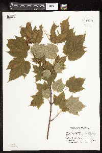 Acer spicatum Lamarck 931775[1094065]Smith, Welby R. 204521992-06-20 United States, Minnesota, Wadena, On the north side of a gravel road, about one mile west of Manahga SE of NE of section;;138N;35W;20, 46.7547222 -95.1216667 |
MIN:Plants | 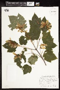 Acer spicatum Lamarck 935462[1094066]Smith, Welby R. 331402011-08-02 United States, Minnesota, Koochiching, About 10 miles E-NE of Craigville. SE of NE of section;Koochiching State Forest;063N;24W;16, 47.9450167 -93.4042833 |
MIN:Plants |  Acer spicatum Lamarck 939676[1283401]Smith, Welby R. 321692010-08-29 United States, Minnesota, Cook, On the north side of Bouder Lake, about 15 miles north of Lutsen. SW of NW of section;Superior National Forest;062N;03W;19, 47.8426741 -90.7621947 |
MIN:Plants |  Acer spicatum Lamarck 96613[1283400]Smith, Welby R. 320882010-08-28 United States, Minnesota, Cook, About 8 miles N-NW of Hovland. NE of SW of section;Grand Portage State Forest;063N;03E;11, 47.9530556 -90.0327778 |
MIN:Plants |  Acer spicatum Lamarck 942003[1283405]Smith, Welby R. 323242010-09-07 United States, Minnesota, Saint Louis, Just northeast of the junction of Highways 110 and 16 near Fairbanks. NW of SW of section;;0057;013;33, 47.3766808 -92.0004719 |
MIN:Plants |  Acer spicatum Lamarck 632193[1283396]KenKnight, Glenn 1950-07-25 United States, Minnesota, Clearwater, KenK's yard, Greenwood Township,, 47.577653 -95.379024 |
MIN:Plants | 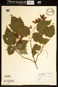 Acer spicatum Lamarck 632134[1283397]KenKnight, Glenn 1950-07-25 United States, Minnesota, Clearwater, Clearbrook Ken K's yard, 47.691901 -95.431123 |
MIN:Plants | 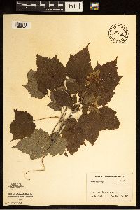 Acer spicatum Lamarck 650480[1283398]Stork, H.E. United States, Minnesota, Itasca, Bowstring [Chippewa National Forest], 47.537188 -93.905046 |
MIN:Plants | 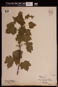 Acer spicatum Lamarck 952633[1292195]Stork, H. E. s.n.1927-05-14 United States, Minnesota, Goodhue, Welch, red wing, Lake City collection, 44.562468 -92.533801 |
MIN:Plants | 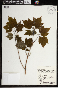 Acer spicatum Lamarck 967966[1368529]T. J. S. Whitfeld 21422019-06-16 United States, Minnesota, Lake, Boundary Waters Canoe Area Wilderness, 50 m from south shore of Insula Lake, in area burned in 2011 Pagami Creek Fire, 47.89895 -91.281958, 460m |
Google Map
Google Maps is a web mapping service provided by Google that features a map that users can pan (by dragging the mouse) and zoom (by using the mouse wheel). Collection points are displayed as colored markers that when clicked on, displays the full information for that collection. When multiple species are queried (separated by semi-colons), different colored markers denote each individual species.