University of Minnesota
http://www.umn.edu/
612-625-5000
http://www.umn.edu/
612-625-5000
Minnesota Biodiversity Atlas
Bell Museum
Dataset: MIN-Plants
Taxa: Sapindaceae
Search Criteria: excluding cultivated/captive occurrences
Bell Museum plants | |
 MIN:Plants |  Acer rubrum L. 690641[1093600]Smith, Welby R. 4461978-05-06 United States, Minnesota, Wright, [corrected locality per W.R. Smith, Dec 2017] T121N R26W SW1/4 NW1/4 section 10, 45.306991 -93.949448 |
MIN:Plants | 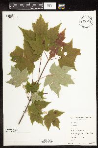 698981[1093687]Sather, Nancy; et al. 4801977-08-15 United States, Minnesota, Saint Louis, St. Louis Co. ... at the end of Skibo Vista Road, plot G42. NE1/4 NW1/4 Sec. 17, T57N, R13W.;Superior National Forest;057N;13W;17, 47.42263 -92.01562 |
MIN:Plants |  699500[1093685]Ziegler, S.; et al. 19301975-07-21 United States, Minnesota, Houston, Upper Mississippi National Wildlife Refuge. Mississippi River Navigation Pool 8...Houston Co, Island 19, Mississippi River mile #694.6, large island W side of main channel...S end of island...T104N R3W Sec. 31. 104N 03W 31, 43.76879 -91.25009 |
MIN:Plants | 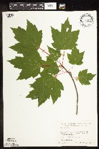 700896[1093671]Dorio, J. 8171977-08-29 United States, Minnesota, Morrison, Morrison Co.; Lake Alexander, ca. 7 mi N of Randall on co. rd 6 [co. #1?]; T131N R30W Sec. 6;Lake Alexander Preserve, The Nature Conservancy;131N;30W;6, 46.18707 -94.50623 |
MIN:Plants |  708826[1093676]Wheeler, Gerald 38141979-06-13 United States, Minnesota, Carlton, Ca. 6 mi. SSE of Wrenshall. Ca. 1 mi. E of Hwy. 23 and just S of the Soo Line R.R. tracks. T47N, R16W, Sec. 22 and 27.;;;;, 46.54755 -92.36291 |
MIN:Plants |  712084[1093635]Smith, Welby 18261979-08-14 United States, Minnesota, Wright, Wright Co. N side of st. hwy 55, 2.0 mi E of its jnc with co. rd 8 in Maple Lake; T120N R26W NE1/4 NW1/4 Sec. 9;;120N;26W;9, 45.21646 -93.96025 |
MIN:Plants |  715287[1093664]Farrell, P. 781979-07-12 United States, Minnesota, Beltrami, Lake Bemidji Bog SNA: 1 mi. NW of Lake Bemidji, N1/2 of NW1/4 of Sec. 24, T147N, R33W.;;;;, 47.53321 -94.81031 |
MIN:Plants |  715325[1093663]Farrell, P. 771979-07-12 United States, Minnesota, Beltrami, Lake Bemidji Bog SNA: 1 mi. NW of Lake Bemidji, N1/2 of NW1/4 of Sec. 24, T147N, R33W.;;147N;33W;24, 47.53321 -94.81031 |
MIN:Plants | 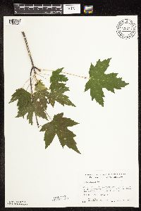 722244[1093645]Wheeler, Gerald 52951980-07-02 United States, Minnesota, Rice, On the W side of the Cannon River. ;Cannon River Wilderness Park;111N;20W;34, 44.37765 -93.21131 |
MIN:Plants | 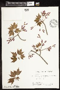 722473[1093596]Lustig, K. 3001979-05-24 United States, Minnesota, Anoka, Anoka County...Boot Lake SNA, 18 mi SE of Cambridge; Sec. 17, 18, 19, 20 T33N R22W;Boot Lake Scientific Natural Area;033N;22W;00, 45.34066 -93.08146 |
MIN:Plants | 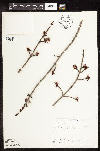 722531[1093623]Lustig, K. 2371979-05-03 United States, Minnesota, Anoka, Anoka County...Boot Lake SNA, 18 mi SE of Cambridge; Sec. 17, 18, 19, 20 T33N R22W;Boot Lake Scientific Natural Area;033N;22W;00, 45.34066 -93.08146 |
MIN:Plants | 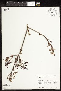 723648[1093627]Smith, Welby 19561980-04-28 United States, Minnesota, Wright, Wright Co. On S side of co. rd 30, ca. 3/4 mi E of its jnc with st. hwy 25; T118N R26W SE1/4 NE1/4 Sec. 24;;118N;26W;24, 45.01415 -93.90022 |
MIN:Plants |  723730[1093622]Smith, Welby 19501980-04-28 United States, Minnesota, Wright, Wright Co. 2 mi SE of Silver Creek and 1/4 mi E of Twp. rd; T121N R26W SE1/4 NE1/4 Sec. 16;;121N;26W;16, 45.28924 -93.96422 |
MIN:Plants |  723926[1093628]Smith, Welby 19401980-04-20 United States, Minnesota, Wright, M Schmidt Crawford Woods Scientific Natural Area. Wright Co. Near SW shore of Schmidt Lake, about 0.3 mi N of co. hwy 34, 4.5 mi E of its jnc with st. hwy 55 near Buffalo Wright Co. Near SW shore of Schmidt Lake, about 0.3 mi N of co. hwy 34, 4.5 mi E of its jnc with st. hwy 55 near Buffalo; T120N R25W NW1/4 SE1/4 Sec. 25. 120N 25W 25, 45.17276 -93.77599 |
MIN:Plants |  726351[1093636]Smith, Welby 24531980-06-12 United States, Minnesota, Saint Louis, On the N side of co. rd 8, ca. 13 mi due E of Floodwood; T51N R18W NW1/4 SW1/4 Sec. 4;;051N;18W;4, 46.9342 -92.62841 |
MIN:Plants |  729111[1093666]Converse, C. 741980-06-02 United States, Minnesota, Chisago, Chisago Co. Goose Creek Natural Area, 5 mi SE of Rush City; NW1/4 SW1/4 Sec. 6 T36N R20W;Wild River State Park;036N;20W;6, 45.63668 -92.89326 |
MIN:Plants | 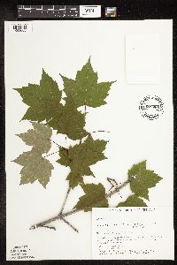 729688[1093665]Converse, C. 1841980-06-06 United States, Minnesota, Pine, Pine Co. St. Croix Natural Area, 21 mi E of Hinckley; NE1/4 SW1/4 Sec. 33 T41N R17W;Saint Croix State Park;041N;17W;33, 45.99052 -92.4984 |
MIN:Plants | 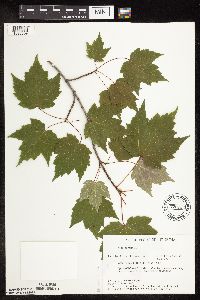 729734[1093609]Converse, C. 1601980-06-05 United States, Minnesota, Pine, Pine Co. Kettle River Natural Area, 5.5 mi E of Hinckley; SW1/4 NW1/4 Sec. 23 T41N R20W;Kettle River Scientific Natural Area / Sandstone National Wildlife Refuge;041N;20W;23, 46.01861 -92.8358 |
MIN:Plants | 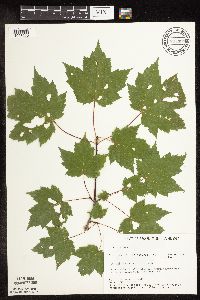 734388[1093690]Severson, M. 6151980-07-30 United States, Minnesota, Becker, Becker Co. Green Water Lake Natural Area, 5 mi W of Ponsford; NW1/4 SE1/4 Sec. 33 T141N R38W;Greenwater Lake Scientific Natural Area / White Earth Indian Reservation;141N;38W;33, 46.98389 -95.4977 |
MIN:Plants | 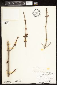 739414[1093621]Stackler, S. 10871976-04-20 United States, Minnesota, Carlton, Carlton Co. Along r.r. tracks, S from Duesler crosssing, about 8 mi. E, 1/4 mi. N of Barnum. T46N, R17W, Sec. 32.;;046N;17W;32, 46.42524 -92.51934 |
MIN:Plants | 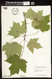 744900[1093667]Smith, Welby 41021981-06-06 United States, Minnesota, Wright, Wright Co. At the NE end of a small unnamed lake in Hanover. NW1/4 SE1/4 Sec. 35, T120N, R24W.;;120N;24W;35, 45.15983 -93.67626 |
MIN:Plants | 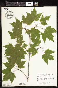 745022[1093679]Smith, Welby 42331981-06-13 United States, Minnesota, Wright, Wright Co. About 1 3/4 mi. SE of Silver Creek, and S of Hwy. 39. NW1/4 NW1/4 Sec. 15, T121N, R26W.;;121N;26W;15, 45.28941 -93.9432 |
MIN:Plants | 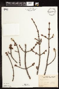 763128[1093598]Gilbert, H. 611923-05-12 United States, Minnesota, Saint Louis, Duluth;;;;, 46.78333 -92.10639 |
MIN:Plants | 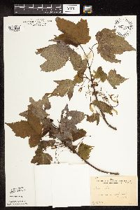 763129[1093585]Gilbert, H. 1741923-06-08 United States, Minnesota, Saint Louis, Duluth;;;;, 46.78333 -92.10639 |
MIN:Plants | 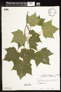 774131[1093616]Monson, Paul 55131983-06-20 United States, Minnesota, Saint Louis, Squaw Narrows, Lake Namakan. Island near number 4 marker. NE1/4 NE1/4 Sec. ;Voyageurs National Park;069N;19W;12, 48.47745 -92.71424 |
MIN:Plants | 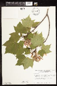 774321[1093584]Monson, Paul 53001983-06-14 United States, Minnesota, Saint Louis, Voyageurs National Park. R20W, T69N, SW1/4 NW1/4 Sec. 25. Kabetogama Narrows Ranger Station.;Voyageurs National Park;069N;20W;25, 48.43325 -92.84232 |
MIN:Plants | 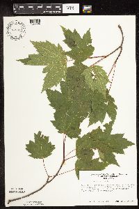 776310[1093694]Morley, T. 16371985-07-21 United States, Minnesota, Rice, Ca. 1/2 mi S of E side of Shields Lake; T110N R22W SE1/4 SW1/4 Sec. 2;;110N;22W;2, 44.36294 -93.43306 |
MIN:Plants | 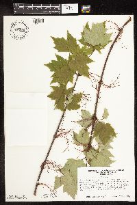 776353[1093577]Morley, T. 15981985-05-27 United States, Minnesota, Dakota, Murphy-Hanrahan County Park Reserve. Dakota Co. W of outermost cross-country ski trail in Hanrehan Park Reserve. Park is neat the easternmost trail, just S Dakota Co. W of outermost cross-country ski trail in Hanrehan Park Reserve. Park is neat the easternmost trail, just S of where the trail bends to the W. Ca. T115N, R21W, N1/2 NE1/4 Sec. 34.. 115N 21W 34, 44.72472 -93.33345 |
MIN:Plants |  776498[1093702]Wheeler, Gerald 89231985-07-23 United States, Minnesota, Itasca, Marcell Bog, ca. 18 mi N of Grand Rapids on rte 49, between Cutaway Lake and Spring Lake; T58N R25W Sec. 13;Chippewa National Forest;058N;25W;13, 47.50744 -93.45971 |
MIN:Plants |  824329[1093637]Marion, J. s.n.1982-00-00 United States, Minnesota, Cook, Cook Co, North Shore of Lake Superior, ca. 200 ft. from lakeshore.;North Shore;;;, 47.46396 -91.02551 |
MIN:Plants |  829331[1093608]Myhre, K. 20111992-06-01 United States, Minnesota, Cass, Cass County...Located 2 mi NE of the town of Pillager; T133N R30W SW1/4 of NW1/4 of Sec 10;;133N;20W;10, 46.34789 -94.44309 |
MIN:Plants |  829432[1093614]Myhre, K. 22961992-06-18 United States, Minnesota, Cass, Cass Co. Located 1/2 mi S of Inguadona Lake; T140N R27W SW1/4 of NW1/4 of Sec 17;;140N;27W;17, 46.94141 -94.12391 |
MIN:Plants | 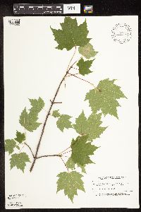 829758[1093682]Fuge, E. 581993-09-07 United States, Minnesota, Dakota, Dakota Co. Lebanon Hills Regional Park; T27N R23W SW1/4 of SW1/4 of Sec.34;Lebanon Hills County Park;027N;23W;34, 44.7829 -93.15686 |
MIN:Plants | 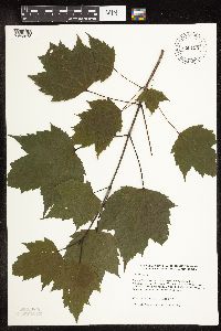 830124[1093573]Wennerstrand, R. 81992-07-03 United States, Minnesota, Roseau, Roseau Co.; SE1/4 SW1/4 Sec.27 T163N R37W;;163N;37W;27, 48.90826 -95.40759 |
MIN:Plants | 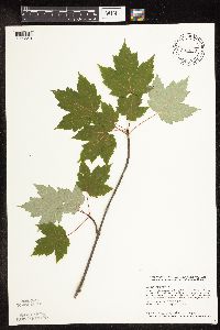 833657[1093649]Smith, Welby 142471988-06-17 United States, Minnesota, Washington, Washington County ... About 4.5 mi sSE of Forest Lake (town). S side of Halfbreed Lake. SE1/4 SE1/4 sec 24, T32N R21W;;032N;21W;24, 45.2425003 -92.9005585 |
MIN:Plants | 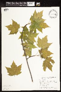 833794[1093670]Smith, Welby 140231988-05-14 United States, Minnesota, Benton, Benton County ... Wisneski State Wildlife Management Area, about 5 mi due east of Rice; SE1/4 SE1/4 Sec 30, T038N R30W;Wisneski Wildlife Area;038N;30W;30, 45.753334 -94.1166687 |
MIN:Plants |  836199[1093574]Cholewa, A. 24511995-08-25 United States, Minnesota, Aitkin, Aitkin Co. Savanna Portage State Park, about 17 mi NE of McGregor, Savanna Lake boat access, T50N R22W S6 SE1/4 of NW1/4;Savanna Portage State Park;050N;22W;6, 46.846 -93.17745 |
MIN:Plants |  836279[1093570]Smith, Welby 172981990-07-17 United States, Minnesota, Morrison, Camp Ripley Military Reservation. Camp Ripley Military Reservation. Morrison Co.; On the S side of Argonne Road, about 0.5 km S of Ferrell Lake; UTM: 3907 Camp Ripley Military Reservation. Morrison Co.; On the S side of Argonne Road, about 0.5 km S of Ferrell Lake; UTM: 390700E 5106500N T130N R30W NE1/4 of NE1/4 of Sec 2. 130N 30W 2, 46.10023 -94.4217 |
MIN:Plants |  841553[1093686]Smith, Welby 150991988-09-25 United States, Minnesota, Goodhue, Goodhue County...Hay Creek Recreation Area, about 2 mi S of Red Wing...NE1/4 NE1/4 sec.12, T112N R15W;Dorer Memorial Hardwood State Forest;112N;15W;12, 44.5247231 -92.5538864 |
MIN:Plants |  453104[1093648]Gonsoski, J. 11996-06-16 United States, Minnesota, Clearwater, NE NE Sec. 1 T143N R36W Clearwater Co. Along Shirley Rd. west of Hwy. 200 .3 km - south side of road;Itasca State Park;143N;36W;01, 47.23229 -95.18024 |
MIN:Plants | 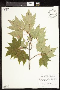 478274[1093684]Smith, Welby 289492000-08-09 United States, Minnesota, Koochiching, Koochiching County ... On the west side of Silverdale ... T 64N R 22W SW1/4 of NE1/4 of Sec 35;Koochiching State Forest;064N;22W;35, 47.9866676 -93.1188889 |
MIN:Plants |  492387[1093564]Smith, Welby 269221998-04-22 United States, Minnesota, Itasca, Itasca County ... About 2 miles northwest of Squaw Lake ... T 148N R 28W SW1/4 of SW1/4 of Sec 1;Chippewa National Forest / Leech Lake Indian Reservation;148N;28W;01, 47.6633339 -94.1741638 |
MIN:Plants |  900944[1093569]Smith, Welby 291242001-04-24 United States, Minnesota, Anoka, Lamprey Pass Wildlife Management Area. Anoka County...Lamprey Pass State Wildlife Management Area, about 2 miles SW of Forest Lake (town)...T32N R22W SW1/4 of NE1/4 of Sec 13. 032N 22W 13, 45.2630556 -93.0269444 |
MIN:Plants |  900941[1093565]Smith, Welby 291232001-04-24 United States, Minnesota, Anoka, Lamprey Pass Wildlife Management Area. Anoka County...Lamprey Pass State Wildlife Management Area, about 2 miles SW of Forest Lake (town)...T32N R22W SW1/4 of NE1/4 of Sec 13. 032N 22W 13, 45.2630556 -93.0269444 |
MIN:Plants |  491647[1093615]Smith, Welby 276001999-04-12 United States, Minnesota, Anoka, Carlos Avery Wildlife Management Area. Anoka County ... Carlos Avery State Wildlife Management Area; about 5 miles west of Wyoming (town) ...T33N R22W NE1/4 of NW1/4 of Sec. 20. 033N 22W 20, 45.3391685 -93.1149979 |
MIN:Plants |  508738[1093683]Smith, Welby 287362000-07-12 United States, Minnesota, Mille Lacs, Mille Lacs Kathio State Park. Mille Lacs County ... Mille Lacs Kathio State Park, about 8 miles northwest of Onamia ... T 42N R 27W SW1/4 of SE1/4 of Sec 5. 042N 27W 5, 46.1286111 -93.7725 |
MIN:Plants |  456141[1093593]Smith, Welby 286922000-07-11 United States, Minnesota, Aitkin, Aitkin County ... Rice Lake National Wildlife Refuge; about 5 mi SSW of McGregor ... T47N R24W SE1/4 of SW1/4 of Sec 23;Rice Lake National Wildlife Refuge;047N;24W;23, 46.538887 -93.3422241 |
MIN:Plants |  505464[1093619]Smith, Welby 291642001-05-31 United States, Minnesota, Pine, Pine County ... Banning State Park, about 2.5 miles north-northeast of Sandstone ... T43N R20W SW1/4 of NW1/4 of Sec 35;Banning State Park;043N;20W;35, 46.167778 -92.8419418 |
MIN:Plants | 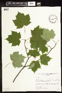 493371[1093572]Gerdes, Lynden; et al. 36411999-07-26 United States, Minnesota, Cook, Boundary Waters Canoe Area Wilderness / Superior National Forest. T65N R03E S30SENWNW. Cook County...Superior National Forest, East Pike Lake area, BWCAW. On top of an east-facing cliff feature approximately 0.5 mile north of lake.. 065N 03E 30, 48.08617 -90.11141 |
MIN:Plants | 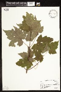 461729[1093680]Little Jr., Elbert 427861991-07-24 United States, Minnesota, Cook, Cook Co.; Eagle Mt, Superior National Forest [ca.] 10 mi N of Grand Marais.;Boundary Waters Canoe Area Wilderness / Superior National Forest;063N;02W;, 47.93319 -90.57404 |
MIN:Plants | 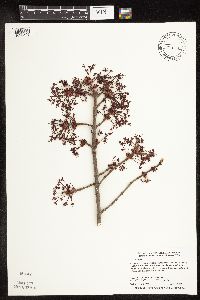 429025[1093592]Smith, Welby 269051998-04-17 United States, Minnesota, Anoka, Lamprey Pass Wildlife Management Area. Anoka County ... Lamprey Pass State Wildlife Management Area, about 2 miles southwest of Forest Lake (town) ...T32N R22W SW1/4 of NE1/4 of Sec 13. 032N 22W 13, 45.2619438 -93.0294418 |
MIN:Plants | 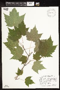 909297[1093567]Smith, Welby 312012008-08-19 United States, Minnesota, Beltrami, Red Lake State Forest. Beltrami County...Along the Tamarac River, near where it enters Upper Red Lake in Waskish...T 154N R 30W NW1/4 of NW1/4 of Sec 9. 154N 30W 9, 48.1755556 -94.5063889 |
MIN:Plants |  476844[1093576]Smith, Welby 283452000-04-05 United States, Minnesota, Kanabec, Ann Lake Wildlife Management Area. Kanabec County ... Near the north boundary of Ann Lake State Wildlife Management Area, about 5 miles NW of Mora ... T 40N R 24W NE1/4 of NE1/4 of Sec 30. 040N 24W 30, 45.9255556 -93.3763889 |
MIN:Plants |  439155[1093606]Smith, Welby 241361994-05-24 United States, Minnesota, Anoka, about two miles northeast of Coon Lake Beach. SW1/4 of SE1/4 of Sec;Boot Lake Scientific Natural Area;033N;22W;18, 45.3436127 -93.1266632 |
MIN:Plants |  438453[1093705]Smith, Welby 256051995-05-10 United States, Minnesota, Scott, Scott County...Murphy-Hanrahan Park Reserve, on the south side of Savage...T 115N R 21W NE1/4 of SE1/4 of Sec 33;Murphy-Hanrahan County Park Reserve;115N;21W;33, 44.7238889 -93.3416667 |
MIN:Plants |  476989[1093607]Smith, Welby 255951995-04-27 United States, Minnesota, Wright, Lake Maria State Park. Wright County ... In Lake Maria State Park, about one mile east of the town of Silver Creek ... T 121N R 26W SW1/4 of SW1/4 of Sec 3. 121N 26W 3, 45.3130569 -93.953331 |
MIN:Plants |  509071[1093681]Smith, Welby 283612000-04-09 United States, Minnesota, Washington, William O'Brien State Park. Washington County ... William O'Brien State Park, about 1.5 miles north of Marine on St. Croix ... T 32N R 19W NW1/4 of NE1/4 of Sec 31. 032N 19W 31, 45.2233333 -92.7613889 |
MIN:Plants |  921948[1093578]Smith, Welby 250001994-08-02 United States, Minnesota, Wadena, About 2 miles south of Sebeka.. NW1/4 of NE1/4 of Sec ;;136N;35W;15, 46.5994444 -95.0825 |
MIN:Plants | 921940[]Smith, Welby 250021994-08-02 United States, Minnesota, Wadena, About 2 miles south of Sebeka.. NW1/4 of NE1/4 of Sec ;;136N;35W;15, 46.5994444 -95.0825 |
MIN:Plants |  934826[1093563]Whitfeld, T. J. S.; et al. 8742012-09-05 United States, Minnesota, Houston, Crooked Creek Unit;Dorer Memorial Hardwood State Forest;;;, 43.63714 -91.2844647 |
MIN:Plants |  939673[1283404]Smith, Welby R. 321662010-08-29 United States, Minnesota, Cook, On the north side of Bouder Lake, about 15 miles north of Lutsen. SW of NW of section;Superior National Forest;062N;03W;19, 47.8426741 -90.7621947 |
MIN:Plants |  Acer rubrum L. 967863[1368472]Drew, L.A. s.n.1969-07-27 United States, Minnesota, Clearwater, Itasca State Park; T144W R36W sec. 35 NW 1/4 SW 1/4, 47.157085 -95.208916 |
MIN:Plants | Acer rubrum L. []Timothy J. S. Whitfeld 35442023-05-24 United States, Minnesota, Washington, Crystal Spring Scientific and Natural Area, 0.4 miles northeast of the intersection of Scandia Trail North and Hwy 95, 45.2584 -92.76598, 273m |
MIN:Plants |  Acer rubrum L. 975963[1373516]Smith, Welby R WRS36672 United States, Minnesota, Anoka, Carlos Avery State Wildlife Management Area, About 11.3 km (7 miles) NW of the approximate center of the town of Forest Lake., 45.32615 -93.11282 |
MIN:Plants |  Acer rubrum L. 975962[1373515]Smith, Welby R WRS366732020-05-19 United States, Minnesota, Mille Lacs, Mille Lacs State Wildlife Management, about 14.5 km (9 miles) S-SE of Onamia., 45.95279 -93.59167 |
MIN:Plants |  491540[1093561]Schimpf, D. DJS3462003-08-30 United States, Minnesota, Saint Louis, St. Louis County, Duluth. T50N R14W NW1/4 Sec 23 ... Chester Creek just downstream of 4th St. bridge.;;050N;14W;23, 46.80225 -92.08091 |
MIN:Plants |  923922[1093560]Moriarity, J. s.n.2011-06-11 United States, Minnesota, Dakota, Inver Grove Heights, Macalester College's Katherine Ordway Natural History Study Area.;;027N;22W;22, 44.81187 -93.03436 |
MIN:Plants |  933855[1093559]Schimpf, D. DJS6932012-07-27 United States, Minnesota, Saint Louis, Duluth;050N;14W;33, 46.772046 -92.12014 |
MIN:Plants |  968244[1368860]Morgan Florsheim 652017-10-13 United States, Rhode Island, Providence, East Bay Bike Path near Watchemoket Cove, off Veterans Memorial Parkway., 41.8026027778 -71.382875, 5m |
MIN:Plants |  Acer glabrum Torrey 230465[1095066]Congdon, J. s.n.1890-08-14 United States, California, Mariposa, Yosemite Cliffs, Glacier Point Trail, Mariposa County;Yosemite National Park;;;, 37.73083 -119.57278 |
MIN:Plants |  Acer glabrum Torrey 647372[1283394]Stork, H.E. 0000-00-00 United States, Yellowstone National Park, 44.426573 -110.467041 |
MIN:Plants |  Acer glabrum Torrey 953250[1291766]Knowlton, G. F. 15 United States, Utah, Cache |
MIN:Plants |  acer glabrum Torrey 0967766[1368322]F.W. Bieberdorf s.n.1939-00-00 United States, Montana |
MIN:Plants | Acer glabrum Torrey []Weiblen, G. D. GW16452002-07-26 United States, Colorado, Gunnison, trail to Virginia Basin, above Gothic townside, 38.95 -106.983333, 3110m |
MIN:Plants | Aesculus flava Aiton 511292[]US Nat. Arboretum staff 921975-00-00 United States, District of Columbia, USNA [Nat. Arboretum] |
MIN:Plants | Aesculus flava Aiton 511291[]US Nat. Arboretum staff 871974-00-00 United States, District of Columbia, USNA [Nat. Arboretum] |
MIN:Plants | Aesculus glabra Willdenow 511289[]US Nat. Arboretum staff 861974-00-00 United States, District of Columbia, USNA [Nat. Arboretum] |
MIN:Plants | Aesculus glabra Willdenow 511290[]US Nat. Arboretum staff 911975-00-00 United States, District of Columbia, USNA [Nat. Arboretum] |
MIN:Plants |  Aesculus glabra Willdenow 934827[1094211]Whitfeld, T. J. S.; et al. 8732012-07-17 United States, Minnesota, Goodhue, State Forest 2.5 miles south west of Frontenac. UTM: 15T054831, 4925881;Dorer Memorial Hardwood State Forest;;;, 44.484626 -92.3923942 |
MIN:Plants |  Aesculus glabra Willdenow 959815[1318119]Wible, Paul G. 1928-08-14 United States, Indiana, Lawrence |
MIN:Plants | Aesculus glabra Willdenow []Donna C. Amundson 221970-05-09 United States, Iowa, Marion, NW quarter Sec. 21 T75N, R19W, near English Creek |
MIN:Plants |  Aesculus glabra Willdenow 976374[1403134]Dunevitz, Hannah L. 3881991-06-20 United States, Minnesota, Winona, in Garvin Heights City Park in Winona. On a steep east-facing bluff on the south side of Highway 61, 44.03 -91.65 |
MIN:Plants | Aesculus glabra Willdenow []Donna C. Amundson 221970-05-09 United States, Iowa, Marion, NW quarter Sec. 21 T75N R19W, near English Creek, 41.288326 -93.057407 |
MIN:Plants |  899119[1093741]Smith, Welby 259011995-08-23 United States, Minnesota, Renville, Skalbakken County Park. Renville County...Skalbakken County park...Minnesota River, about 6 miles east of Granite Falls...T115N R38W SE1/4 of SW1/4 of Sec 27. 115N 38W 27, 44.7347222 -95.4169444 |
MIN:Plants |  479388[1093727]Lee, Michael; et al. MDL38572004-08-31 United States, Minnesota, Todd, TODD COUNTY ... Along the Long Prairie River, just downstream from the Hwy 71 bridge in the city limits of Long Prairie ... T129N R33W NE1/4 of SW1/4 of SE1/4 Sec.17. 129N 33W 17, 45.98365 -94.86602 |
MIN:Plants | 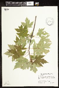 505410[1093744]Smith, Welby 273941998-07-16 United States, Minnesota, Rock, Rock County ... Blue Mounds State Park, about one mile north of Luverne ... T103N R45W SE1/4 of SE1/4 of Sec 26;Blue Mounds State Park;103N;45W;26, 43.6927778 -96.1958333 |
MIN:Plants | 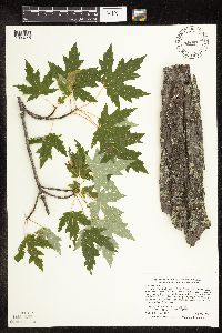 454967[1093745]Smith, Welby 287872000-07-21 United States, Minnesota, Pine, Pine County ... St. Croix State Park; where Sand Creek joins the St. Croix River ... T40N R18W SE1/4 of SW1/4 of Sec 19;Saint Croix State Park;040N;18W;19, 45.9322222 -92.64 |
MIN:Plants | 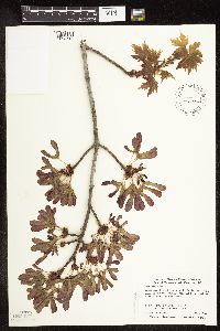 492693[1093710]Smith, Welby 283742000-04-23 United States, Minnesota, Wabasha, Dorer Memorial Hardwood State Forest. Wabasha County ... Kruger State Recreation Aera. In the Zumbro River Valley about 4 miles N-NW of Kellogg ... T 110N R 11W SE1/4 of SE1/4 of sec 12. 110N 11W 12, 44.3397222 -92.0763889 |
MIN:Plants | 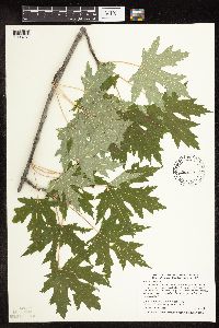 454470[1093751]Smith, Welby 286802000-07-09 United States, Minnesota, Ramsey, Ramsey County ... Swede's Hollow City Park, in St. Paul. Along a small stream ... T29N R22W SE1/4 of NW1/4 of Sec 32;;029N;22W;32, 44.9577789 -93.0763855 |
MIN:Plants | 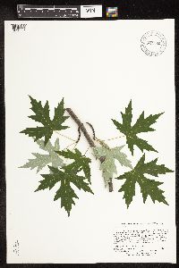 914150[1093725]Lee, Michael; et al. MDL44592007-07-25 United States, Minnesota, Hubbard, Crow Wing Chain Wildlife Management Area. Hubbard County ... Crow Wing Chain Wildlife Management Area. Along the west bank of the Crow Wing River just downstream from the mouth of the Shell River, two miles north of Huntersville ... T139N R33W W1/2 of SE1/4 of SW1/4 Sec.32 ... UTM: 5185418N 356060E. 134N 30W 16, 46.84797 -94.8494 |
MIN:Plants |  909895[1093790]Smith, Welby 252531994-08-23 United States, Minnesota, Carver, Minnesota Valley State Park. Carver County...Minnesota Valley State Park, about 1.5 miles north-northeast of Belle Plain...floodplain of the Minnesota River...T 114N R 24W SW1/4 of SE1/4 of Sec 30. 114N 24W 30, 44.6458333 -93.7541667 |
MIN:Plants |  920460[1093723]Smith, Welby 257591995-07-18 United States, Minnesota, Pipestone, Split Rock Creek State Park. Pipestone County ... Split Rock Creek State Park, about 7 miles south-southwest of Pipestone ... Split Rock Creek ... T105N R46W NW1/4 of SW1/4 of Sec 15. 105N 46W 15, 43.8986111 -96.3638889 |
MIN:Plants |  482167[1093748]Wheeler, Gerald 159851997-06-07 United States, Minnesota, Nicollet, Nicollet Co.; Ca. 4 mi. SE of Fort Ridgely State Park on Rte. 21; near small lake; SE1/4 SW1/4 Sec. 15 T111N R32W (Ridgely 15). 111N 32W 15, 44.411485 -94.673435 |
MIN:Plants |  473342[1093709]Lee, Michael MDL17021997-06-10 United States, Minnesota, Stearns, Spring Hill County Park. Stearns Co.; Spring Hill County Park 2-1/2 miles east of the town of Spring Hill; along the Sauk River; T124N R33W SE1/4 of SW1/4 Sec. 24. 124N 33W 24, 45.53551 -94.77222 |
MIN:Plants |  151099[1093820]Sandberg, John s.n.1886-04-00 United States, Minnesota, Goodhue, [no further data];;;;, 44.41 -92.72 |
MIN:Plants |  151115[1093791]Sheldon, Edmund S4681891-06-00 United States, Minnesota, Blue Earth, Madison Lake;;108N;25W;, 44.15249 -93.82835 |
MIN:Plants |  151116[1093777]Arthur, J.; et al. B1091886-07-17 United States, Minnesota, Saint Louis, Vermilion Lake;;;;, 47.89167 -92.36667 |
MIN:Plants |  151117[1093756]Holzinger, John s.n.1895-06-20 United States, Minnesota, Winona, Winona Co.;;;;, 43.96667 -91.76667 |
MIN:Plants |  151119[1093754]Aiton, G. s.n.1891-06-00 United States, Minnesota, Hennepin, Collected near Minneapolis;;;;, 44.98 -93.26361 |
MIN:Plants |  151120[1093818]G. & L. 29-21885-06-00 United States, Minnesota, Chippewa River;;;;, 45.58233 -95.69092 |
Google Map
Google Maps is a web mapping service provided by Google that features a map that users can pan (by dragging the mouse) and zoom (by using the mouse wheel). Collection points are displayed as colored markers that when clicked on, displays the full information for that collection. When multiple species are queried (separated by semi-colons), different colored markers denote each individual species.