University of Minnesota
http://www.umn.edu/
612-625-5000
http://www.umn.edu/
612-625-5000
Minnesota Biodiversity Atlas
Bell Museum
Dataset: MIN-Plants
Taxa: Sapindaceae
Search Criteria: excluding cultivated/captive occurrences
Bell Museum plants | |
 MIN:Plants |  803026[1093731]Smith, Welby 117851986-06-14 United States, Minnesota, Olmsted, Oxbow County Park. Olmsted County ... Oxbow County Park, about 3 mi N of Byron, on the banks of the Zumbro River; NW1/4 NW1/4 Sec. 17 T107N R15W. 107N 15W 17, 44.0769463 -92.6538925 |
MIN:Plants |  830100[1093714]Myhre, K. 17431992-05-11 United States, Minnesota, Cass, Cass Co. Located along the N bank of the Crow Wing River at the town of Pillager; T133N R30W SW1/4 of NW1/4 of Sec 21;;133N;30W;21, 46.32364 -94.47078 |
MIN:Plants |  830114[1093832]Wennerstrand, R. 31992-07-05 United States, Minnesota, Roseau, Roseau Co. West Branch of the Warroad River; SW1/4 SW1/4 Sec.6 T161N R36W;;161N;36W;6, 48.79257 -95.34139 |
MIN:Plants |  833793[1093713]Smith, Welby 140241988-05-14 United States, Minnesota, Benton, Benton County ... Wisneski State Wildlife Management Area, about 5 mi due E of Rice; SE1/4 SE1/4 Sec 30, T38N R30W;Wisneski Wildlife Area;038N;30W;30, 45.753334 -94.1166687 |
MIN:Plants |  833808[1093839]Smith, Welby 141281988-05-30 United States, Minnesota, Lac Qui Parle, Lac Qui Parle Co. About 5 mi W-NW of Montevideo; small stream draining into the Minnesota River. SW1/4 SE1/4 sec.5, T117 Lac Qui Parle Co. About 5 mi W-NW of Montevideo; small stream draining into the Minnesota River. SW1/4 SE1/4 sec.5, T117N R41W. 117N 41W 5, 44.97111 -95.83083 |
MIN:Plants |  836364[1093715]Smith, Welby 182141990-08-30 United States, Minnesota, Morrison, Camp Ripley Military Reservation. Camp Ripley Military Reservation Morrison Co. About 1 km E of the junction of Chorwan Road and East Boundary Road. UTM: Camp Ripley Military Reservation Morrison Co. About 1 km E of the junction of Chorwan Road and East Boundary Road. UTM: 396600E 5124800N T132N R29W SE1/4 of SW1/4 of Sec 4. 132N 29W 4, 46.27293 -94.3442 |
MIN:Plants |  840282[1093743]Myhre, K. 43961993-08-08 United States, Minnesota, Pine, Pine Co. Located 1 mi N of the town of Sandstone; T42N R20W SW1/4 of SW1/4 of Sec 3.;Banning State Park;042N;20W;3, 46.15073 -92.85555 |
MIN:Plants |  833927[1093717]Smith, Welby 140541988-05-20 United States, Minnesota, Kanabec, On the west side of the Snake River, just south of the Highway 3 crossing. NE1/4 NW1/4 of section;;041N;23W;22, 46.0238889 -93.2333333 |
MIN:Plants |  482395[1093747]Wheeler, Gerald 171431997-08-11 United States, Minnesota, Chippewa, Chippewa Co.; Ca. 3 mi. SE of Granite Falls, SW of Pete's Pt. Rd. SE; SW1/4 SW1/4 NE1/4 Sec. 13 T115N R39W (Granite Falls 13 'S'). 115N 39W 13, 44.76871 -95.48999 |
MIN:Plants |  913902[1093738]Smith, Welby 252291994-08-23 United States, Minnesota, Sibley, Vale Wildlife Management Area. Sibley County... Vale State Wildlife Management Area; about 3 miles northwest of Henderson...High Island Creek... T113N R26W SE1/4 of NW1/4 of Sec 27. 113N 26W 27, 44.5680556 -93.9413889 |
MIN:Plants |  473218[1093750]Lee, Michael MDL16281997-05-22 United States, Minnesota, Stearns, Stearns County...Mississippi River County Park along the Mississippi River six miles north of Sartell; T126N R28W NE1/4 of SE1/4 Sec. 16. 126N 28W 16, 45.72277 -94.21925 |
MIN:Plants |  477203[1093746]Smith, Welby 171081990-06-28 United States, Minnesota, Waseca, Waseca County ... At the north end of Buffalo Lake, about 3 miles south of Janesville ... T107N R24W NE1/4 of NE1/4 of Sec 20. 107N 24W 20, 44.065834 -93.7300034 |
MIN:Plants |  493658[1093772]Juhnke, C. 060 CMJ FRO1998-08-27 United States, Minnesota, Goodhue, Frontenac State Park. Goodhue County ... main park road ... T 112N R 13W NW NW SW 2;Frontenac State Park;112N;13W;02, 44.49871 -92.36985 |
MIN:Plants |  904717[1093849]Smith, Welby 280631999-07-22 United States, Minnesota, Cottonwood, Talcot Lake Wildlife Management Area. Cottonwood County...Talcot Lake State Wildlife Management Area, about 2 miles N-NE of Dundee...T105N R38W SW1/4 of NE1/4 of Sec 30. 105N 38W 30, 43.8722222 -95.4511111 |
MIN:Plants |  909139[1093771]Smith, Welby 245411994-07-02 United States, Minnesota, Scott, Scott County...In the Minnesota Valley, about 75 miles north of Jordan...on the floodplain...T 115N R 23W SE1/4 of NW1/4 of Sec 9. 115N 23W 9, 44.77986 -93.58992 |
MIN:Plants |  912136[1093752]Smith, Welby 253091994-08-26 United States, Minnesota, Wabasha, Dorer Memorial Hardwood State Forest. Wabasha County...In the Zumbro River Valley, about 2 miles south of Dumfries...floodplain of the Zumbro River... T 110N R 11W SE1/4 of SW1/4 of Sec 22. 110N 11W 22, 44.3113889 -92.1213889 |
MIN:Plants |  906424[1093831]Smith, Welby 275091998-08-11 United States, Minnesota, Koochiching, Pine Island State Forest. Koochiching County...Big Fork River, on the south side of Bigfork [actually town is Big Falls]...T155N R25W SE1/4 of SE1/4 of Sec 35. 155N 25W 35, 48.1972222 -93.8030556 |
MIN:Plants |  923861[1093724]Smith, Welby 203991992-06-12 United States, Minnesota, Le Sueur, About 4 miles SSW of Le Sueur in the Minnesota Valley. SW1/4 of SW1/4 of section.;Chamberlain Woods Scientific Natural Area;111N;26W;22, 44.4005556 -93.9477778 |
MIN:Plants |  921212[1093769]Smith, Welby 249801994-07-27 United States, Minnesota, Crow Wing, Crow Wing State Park. Crow Wing State Park, about 4 miles southwest of Barrows (town). On the bank of the Crow Wing River...T 44N R 32W NW1/4 of SE1/4 of Sec 23. 044N 32W 23, 46.2772222 -94.3391667 |
MIN:Plants |  937792[1283402]Triplett, Laura 102012-09-29 United States, Minnesota, Ramsey, Mounds View, North of County Rd I near trail parking area. 20 ft from trail. Rice Creek.;Rice Creek Trail Regional Park;;;, 45.1125 -93.1794444, 268m |
MIN:Plants | 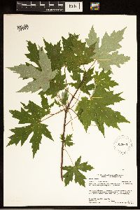 937663[1283403]Gerdes, Lynden B.; Gerdes, D. Lawson 66222012-07-13 United States, Minnesota, Lake, Bald Eagle Lake. Approximately 16.33 miles NW of Isabella, MN along the eastern shoreline.;Boundary Waters Canoe Area Wilderness / Superior National Forest;062N;09W;30, 47.819722 -91.531667 |
MIN:Plants | 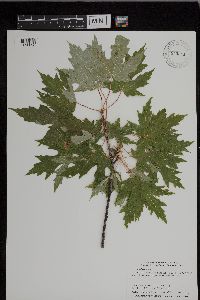 943511[1296626]Smith, Welby R. 34211 United States, Minnesota, Murray |
MIN:Plants | 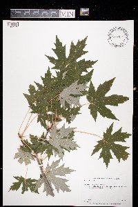 973619[1397173]Bezanson, Char A. 2781991-08-03 United States, Minnesota, Rice, in Sechler Park. In the city of Northfield, 44.449667 -93.170848 |
MIN:Plants | 511284[]US Nat. Arboretum staff 31976-00-00 United States, New York, Orange, Orange Co. |
MIN:Plants | Cupaniopsis curvidens Radlk. 935523[]Takeuchi, W.; Ama , D. 240252008-07-12 Papua New Guinea, Southern Highlands Province; Strickland drainage, Tualapa bivouac.;;;;, -5.285 142.495, 1120m |
MIN:Plants | Rhysotoechia applanata Etman 935515[]Takeuchi, W.; et al. 176362004-11-28 Papua New Guinea, East Sepik Province; Ambunti District, Waskuk Hills, foothill forest close to Garuka village.;;;;, -4.19 142.728, 70m |
MIN:Plants | Ganophyllum falcatum Blume 935510[]Takeuchi, W.; et al. 171992004-11-16 Papua New Guinea, East Sepik Province; Waskuk Hills, near Langu.;;;;, -4.1858333 142.7402778, 30m |
MIN:Plants |  Ganophyllum falcatum Blume 969794[1371383]Weiblen, G. D. & Binatang Research Center NP1A00562013-06-03 Papua New Guinea, Madang, Numba, -5.7222 145.2714, 1200m |
MIN:Plants |  Ganophyllum falcatum Blume 969969[1371548]Weiblen, G. D. & Binatang Research Center NP1A00072013-06-03 Papua New Guinea, Madang, Numba, -5.7222 145.2714, 1200m |
MIN:Plants |  508533[1094213]Lee, Michael MDL8491995-05-10 United States, Minnesota, Wabasha, Along Zumbro River 1/2 mi upstream from Hammond. SWSE of section;Dorer Memorial Hardwood State Forest;109N;14W;21, 44.23093 -92.50127 |
MIN:Plants | Allophylus racemosus NULL 939760[]P 742011-07-07 Costa Rica, Guanacaste, Liberia, , 10.84 -85.61, 320m |
MIN:Plants | 939761[]P 752011-07-07 Costa Rica, Guanacaste, Liberia, , 10.84 -85.61, 320m |
MIN:Plants |  Acer negundo var. interius (Britton) Sargent 919295[1093502]Cholewa, A. 27102010-04-24 United States, Minnesota, Anoka, City of Blaine, Aquatore city park, northeast of picnic area.;;031N;23W;29, 45.1375 -93.2377778 |
MIN:Plants | Acer negundo var. interius (Britton) Sargent 477540[]US Nat. Arboretum staff 61978-00-00 United States, Colorado, Larimer, Larimer Co. |
MIN:Plants |  Acer negundo var. interius (Britton) Sargent 430012[1093501]Smith, Welby 193581991-09-10 United States, Minnesota, Koochiching, Grand Mound Historical Site. Koochiching County...Grand Mound Historic Site, about 18 miles west of International Falls...floodplain of the Rainy River...T 70N R 26W NW1/4 of NE1/4 of sec 32. 070N 26W 32, 48.5158348 -93.7249985 |
MIN:Plants |  Acer negundo var. interius (Britton) Sargent 543079[1093507]Lakela, Olga 215051957-06-01 United States, Minnesota, Saint Louis, Savanna River bank at Floodwood;;051N;20W;, 46.89584 -92.86911 |
MIN:Plants |  Acer negundo var. interius (Britton) Sargent 829322[1093500]Myhre, K. 19521992-05-28 United States, Minnesota, Cass, Cass County...Located 1 mi NE of Battle Point in the Battleground State Forest...T143N R29W NW1/4 of SW1/4 of Sec 25.;Chippewa National Forest / Leech Lake Indian Reservation;143N;29W;25, 47.17589 -94.29655 |
MIN:Plants |  Acer negundo var. interius (Britton) Sargent 838409[1093499]Myhre, K. 43601993-08-07 United States, Minnesota, Pine, Pine County...campground on the Willow River near the town of Willow River...T44N R20W SE1/4 of NE1/4 of Sec 2.;General C C Andrews State Forest;044N;20W;02, 46.32431 -92.83477 |
MIN:Plants |  Acer negundo var. interius (Britton) Sargent 150983[1093505]Bergman, H. 28531913-07-10 United States, Minnesota, Otter Tail, Dent;;;;, 46.55361 -95.71611 |
MIN:Plants |  Acer negundo var. interius (Britton) Sargent 150984[1093506]Bergman, H. 28531913-07-10 United States, Minnesota, Otter Tail, Dent;;N;;, 46.55361 -95.71611 |
MIN:Plants |  Acer negundo var. interius (Britton) Sargent 150985[1093508]Bergman, H. s.n.1912-05-09 United States, Minnesota, Otter Tail, Big Pine Lake, Perham;;;;, 46.61667 -95.5 |
MIN:Plants |  Acer negundo var. interius (Britton) Sargent 456131[1093498]Smith, Welby 185471991-05-21 United States, Minnesota, Todd, About one mile southeast of Osakis, between CSAH 46 and the BN railroad tracks. SW1/4 of NE1/4 of Sec ;;128N;35W;31, 45.8549995 -95.1263885 |
MIN:Plants | Acer negundo var. interius (Britton) Sargent 520651[]US Nat. Arboretum staff s.n.1981-00-00 United States, Idaho, Franklin, [no further data] |
MIN:Plants |  Acer negundo var. interius (Britton) Sargent 480919[1093504]Smith, Welby 281461999-08-17 United States, Minnesota, Itasca, Itasca County ... At an old iron ore mine site about 1 mile southwest of Keewatin ... T 57N R 22W SW1/4 of NE1/4 of Sec 35. 057N 22W 35, 47.3816681 -93.0988922 |
MIN:Plants |  Acer negundo var. interius (Britton) Sargent 921072[1093503]Smith, Welby 248201994-07-14 United States, Minnesota, Koochiching, Sturgeon River Landing, on the south bank of the Sturgeon River about 4 miles west-northwest of Big Falls. SW1/4 of SW1/4 of section;Pine Island State Forest;155N;25W;29, 48.2116667 -93.8836111 |
MIN:Plants |  Acer glabrum var. douglasii (Hooker) Dippel 680302[1095067]Bright, R. 74-2021974-09-12 United States, Idaho, Franklin, Franklin Co, lower part of Hillyard Canyon, 12 miles E of Preston.;;;;, 42.13833 -111.63472, 2195m |
MIN:Plants | 151486[]Pringle, C. 27091889-06-17 Mexico, Nuevo Leon, Valley of Monterey. |
MIN:Plants |  385389[1299095]Degener, O.; et al. 110721937-03-06 United States, Hawaii, Oahu, Waimea Valley, Oahu |
MIN:Plants |  385374[1000852]Degener, O. 124911939-07-28 United States, Hawaii, Maui, Puu Lio northwest of Hopoi Camp, West Maui, 305m |
MIN:Plants |  920354[1093520]Smith, Welby 222811993-06-03 United States, Minnesota, Sibley, Vale Wildlife Management Area. Sibley County...Vale State Wildlife Management Area; in the valley of High Island Creek, about 2.5 miles southwest of its confluence with the Minnesota River...T 113N R 26W NE1/4 of SW1/4 of Sec 27. 113N 26W 27, 44.5625 -93.9427778 |
MIN:Plants |  429220[1093509]Smith, Welby 289852000-08-15 United States, Minnesota, Washington, Afton State Park. Washington County ... Afton State Park; about 7 miles NE of Hastings ... bluff overlooking the St. Croix River ... T 27N R 20W NE1/4 of NW1/4 of Sec 11. 027N 20W 11, 44.8466667 -92.7705556 |
MIN:Plants |  426757[1093512]Juhnke, C. 192 CMJ FRO1999-05-11 United States, Minnesota, Goodhue, Frontenac State Park Goodhue County ... along self-guided trail to quarry ... T112N R13W NE NW SE 2;Frontenac State Park;112N;13W;2, 44.53507 -92.33916 |
MIN:Plants |  420896[1093519]Lakela, Olga 104471950-06-14 United States, Minnesota, Saint Louis, Hunters Hill woods, Woodland Avenue, Duluth;;;;, 46.78333 -92.10639 |
MIN:Plants |  515140[1093515]Cholewa, A. 25521998-06-23 United States, Minnesota, Aitkin, Aitkin Co. Soo Line Trail and Co. Road 5, just south of Palisade, T49N, R25W S27, NE1/4.;;049N;25W;27, 46.70315 -93.49524 |
MIN:Plants |  519621[1093516]Smith, Welby 187721991-06-11 United States, Minnesota, Aitkin, Aitkin County ... on the N shore of Mille Lacs Lake, about 12 mi S of Aitken [sic] ... T45N R27 NE1/4 of SW1/4 of Sec 26;Wealthwood State Forest;045N;27W;26, 46.3508339 -93.7152786 |
MIN:Plants |  830098[1093514]Myhre, K. 17461992-05-11 United States, Minnesota, Cass, Cass County...along the N bank of the Crow Wing River at the town of Pillager...T133N R30W SW1/4 of NW1/4 of Sec.21;;133N;30W;21, 46.32364 -94.47078 |
MIN:Plants |  833124[1093513]Myhre, K. 19081992-05-25 United States, Minnesota, Cass, Cass County...Located 6 mi W of Pine River in the Foothills State Forest...T138N R31W SE1/4 of SE1/4 of Sec.36;Foothills State Forest;138N;31W;36, 46.72569 -94.546 |
MIN:Plants |  834198[1093511]Cholewa, A. 21451995-05-25 United States, Minnesota, Stearns, Stearns Co. Paynesville, Highgrove BioReserve, just S of Koronis Golf Course. T122N R32W S20.;;122N;32W;20, 45.36223 -94.73229 |
MIN:Plants |  670784[1093517]Heitlinger, M. 5711972-06-01 United States, Minnesota, McLeod, McLeod Co.; Schaefer Prairie, collected along E bank of Buffalo Creek; SE1/4 Sec. 34 T115N R29W;Schaefer Prairie, The Nature Conservancy;115N;29W;34, 44.72505 -94.30491 |
MIN:Plants |  511587[1093330]Smith, Welby 289962000-08-16 United States, Minnesota, Fillmore, Forestville State Park. Fillmore County ... Forestville State Park, about 3 miles SW of Carimona ... flood plain of the Root River ... T 102N R 11W SW1/4 of NW1/4 of Sec 18. 102N 11W 18, 43.6402779 -92.2074966 |
MIN:Plants |  439104[1093462]Smith, Welby 283772000-08-28 United States, Minnesota, Wright, Harry Larson County Forest. Wright County ... Harry Larson County Park, about 6 miles west-northwest of Monticello ... T122N R26W SW1/4 of NW1/4 of Sec 35. 122N 26W 35, 45.334446 -93.9277802 |
MIN:Plants |  455617[1093510]Smith, Welby 283722000-04-23 United States, Minnesota, Wabasha, Dorer Memorial Hardwood State Forest. Wabasha County ... Kruger State Recreation Area. In the Zumbro River Valley about 4 miles N-NW of Kellogg ... T 110N R 11W SE1/4 of SE1/4 of Sec 12. 110N 11W 12, 44.3397217 -92.0763855 |
MIN:Plants |  922975[1093518]Smith, Welby 238551993-09-03 United States, Minnesota, Scott, Lawrence Unit; about 4 miles west-southwest of Jordan. SW1/4 NE1/4 of section;Minnesota Valley State Park;114N;24W;28, 44.6547222 -93.7119444 |
MIN:Plants |  Aesculus glabra var. glabra Willdenow 509267[1094212]Kaul, R. 67411990-05-24 United States, Minnesota, Steele, Above the Straight River where Lemond Road approaches Bridge St, Owatonna.;;107N;20W;, 44.06611 -93.22607 |
MIN:Plants |  Dodonaea eriocarpa var. costulata Deg. & Sherff 590312[1000851]Degener, O. 287511964-01-24 United States, Hawaii, Maui, Lower slope of Puu Kole. Lanai, 701m |
MIN:Plants |  Dodonaea eriocarpa var. varians Deg. & Sherff 414758[1000853]Degener, O. 197501949-08-04 United States, Hawaii, Maui, Waiakeakua, Lanai, 610m |
MIN:Plants |  Urvillea biternata Weatherby 558900[1002720]Pringle, C.G. 103801907-07-24 Mexico, Guerrero, Iguala Canyon, 914m |
MIN:Plants |  Matayba boliviana Radlkofer 151441[1001791]Bang, M. 21710000-00-00 Bolivia, [no further data] |
MIN:Plants |  Cupania semidentata Radlk 151378[1000748]Rusby, H.H. 1771896-04-00 Venezuela, Lower Orinoco
Manoa |
MIN:Plants |  Cupaniopsis macropetala Radlk. 920710[]Whitfeld, T.J.S. PA1E00582008-08-13 Papua New Guinea, Madang, Wanang Village, -5.237483 145.115733, 129m |
MIN:Plants |  Cupaniopsis macropetala Radlk. 916767[]Weiblen, G.D. & Binatang Research Center WP3B05892007-06-25 Papua New Guinea, Madang, Wanang Village, -5.2373 145.177183, 115m |
MIN:Plants |  Cupaniopsis macropetala Radlk. 916722[]Weiblen, G.D. & Binatang Research Center WP4B09432007-08-10 Papua New Guinea, Madang, Wanang Village, -5.2373 145.177183, 115m |
MIN:Plants |  Cupaniopsis macropetala Radlk. 922105[]Ctvrtecka, R. 33162008-11-14 Papua New Guinea, Madang, Wanang Village, -5.23088 145.182, 115m |
MIN:Plants | Cupaniopsis stenopetala Radlk. 922104[]Ctvrtecka, R. 18642008-08-21 Papua New Guinea, Madang, Ohu Village, -5.21667 145.683, 100m |
MIN:Plants |  922726[]Ctvrtecka, R. 29802008-10-30 Papua New Guinea, Madang, Wanang Village, -5.23088 145.182, 115m |
MIN:Plants | 903498[] GW27342006-10-06 Papua New Guinea, Madang, Baisarek, -5.233333 145.433333, 283m |
MIN:Plants |  Alectryon ferrugineum Radlk. 922111[]Ctvrtecka, R. 29652008-10-29 Papua New Guinea, Madang, Wanang Village, -5.23088 145.182, 115m |
MIN:Plants |  Harpullia crustacea Radlk. 922123[]Ctvrtecka, R. 44412009-03-05 Papua New Guinea, Madang, Wanang Village, -5.23088 145.182, 115m |
MIN:Plants |  Harpullia longipetala Leenh. 921420[]Whitfeld, T.J.S. OA5B01942008-07-23 Papua New Guinea, Madang, Wanang Village, -5.233683 145.171867, 179m |
MIN:Plants |  Harpullia longipetala Leenh. 916751[]Weiblen, G.D. & Binatang Research Center WP2C03972006-06-16 Papua New Guinea, Madang, Wanang Village, -5.2373 145.177183, 115m |
MIN:Plants |  Harpullia longipetala Leenh. 916795[]Weiblen, G.D. & Binatang Research Center WP2C04652006-06-07 Papua New Guinea, Madang, Wanang Village, -5.2373 145.177183, 115m |
MIN:Plants |  Harpullia longipetala Leenh. 916754[]Weiblen, G.D. & Binatang Research Center WS4A21162006-05-09 Papua New Guinea, Madang, Wanang Village, -5.229583 145.178467, 115m |
MIN:Plants |  Harpullia longipetala Leenh. 922092[]Ctvrtecka, R. 44902009-03-06 Papua New Guinea, Madang, Wanang Village, -5.23088 145.182, 115m |
MIN:Plants |  Harpullia longipetala Leenh. 965843[1356599]Whitfeld, T. J. S. 2087b2019-02-16 Papua New Guinea, Madang, Wanang Conservation Area, inside the Wanang 50 hectare Forest Dynamics Plot, tree tag #502519, -5.232975 145.07455, 150m |
MIN:Plants |  Lepidopetalum micans K.Schum. & Lauterb. 922122[]Ctvrtecka, R. 43652009-03-03 Papua New Guinea, Madang, Wanang Village, -5.23088 145.182, 115m |
MIN:Plants |  Lepidopetalum xylocarpum Radlk. 920776[]Whitfeld, T.J.S. OC3C00962008-07-28 Papua New Guinea, Madang, Wanang Village, -5.2319 145.155767, 218m |
MIN:Plants | Lepidopetalum xylocarpum Radlk. 897269[]Weiblen, G.D. TP4811996-07-31 Papua New Guinea, Simbu, O-Pio 1 ha plot, block 20, Crater Mountain Wildlife Management Area, -6.788611 145.036667, 550m |
MIN:Plants | Lepidopetalum xylocarpum Radlk. 897573[]Weiblen, G.D. TP5791996-07-31 Papua New Guinea, Simbu, O-Pio 1 ha plot, block 24, Crater Mountain Wildlife Management Area, -6.788611 145.036667, 550m |
MIN:Plants | Lepidopetalum xylocarpum Radlk. 897852[]Weiblen, G.D. TP4741996-07-31 Papua New Guinea, Simbu, O-Pio 1 ha plot, block 20, Crater Mountain Wildlife Management Area, -6.788611 145.036667, 550m |
MIN:Plants | Pometia pinnata J.R.Forst. & G.Forst. 916139[]Weiblen, G.D. & Binatang Research Center WP1Z30502008-04-14 Papua New Guinea, Madang, Wanang Village, -5.2373 145.177183, 115m |
MIN:Plants |  Pometia pinnata J.R.Forst. & G.Forst. 916131[]Weiblen, G.D. & Binatang Research Center WP2C03862006-06-16 Papua New Guinea, Madang, Wanang Village, -5.2373 145.177183, 115m |
MIN:Plants |  Pometia pinnata J.R.Forst. & G.Forst. 916129[]Weiblen, G.D. & Binatang Research Center WP4A10452007-08-22 Papua New Guinea, Madang, Wanang Village, -5.2373 145.177183, 115m |
MIN:Plants |  Pometia pinnata J.R.Forst. & G.Forst. 916143[]Weiblen, G.D. & Binatang Research Center WP5A10592007-10-03 Papua New Guinea, Madang, Wanang Village, -5.2373 145.177183, 115m |
MIN:Plants |  Pometia pinnata J.R.Forst. & G.Forst. 916853[]Weiblen, G.D. & Binatang Research Center WP5A11072007-10-12 Papua New Guinea, Madang, Wanang Village, -5.2373 145.177183, 115m |
MIN:Plants |  Pometia pinnata J.R.Forst. & G.Forst. 922753[]Ctvrtecka, R. 31902008-11-11 Papua New Guinea, Madang, Wanang Village, -5.23088 145.182, 115m |
MIN:Plants | Pometia pinnata J.R.Forst. & G.Forst. 905863[]Dahl, C. FAM151999-08-14 Papua New Guinea, Madang, Nearest village: Ohu, -5.233333 145.683333, 200m |
MIN:Plants | Pometia pinnata J.R.Forst. & G.Forst. 897340[]Weiblen, G.D. TP3171996-07-31 Papua New Guinea, Simbu, O-Pio 1 ha plot, block 13, Crater Mountain Wildlife Management Area, -6.788611 145.036667, 550m |
MIN:Plants | Pometia pinnata J.R.Forst. & G.Forst. 897371[]Weiblen, G.D. TP2071996-07-31 Papua New Guinea, Simbu, O-Pio 1 ha plot, block 9, Crater Mountain Wildlife Management Area, -6.788611 145.036667, 550m |
MIN:Plants | Pometia pinnata J.R.Forst. & G.Forst. 897617[]Weiblen, G.D. TP4141996-07-31 Papua New Guinea, Simbu, O-Pio 1 ha plot, block 17, Crater Mountain Wildlife Management Area, -6.788611 145.036667, 550m |
MIN:Plants | Pometia pinnata J.R.Forst. & G.Forst. 899569[]Weiblen, G.D. TP5751996-07-31 Papua New Guinea, Simbu, O-Pio 1 ha plot, block 24, Crater Mountain Wildlife Management Area, -6.788611 145.036667, 550m |
Google Map
Google Maps is a web mapping service provided by Google that features a map that users can pan (by dragging the mouse) and zoom (by using the mouse wheel). Collection points are displayed as colored markers that when clicked on, displays the full information for that collection. When multiple species are queried (separated by semi-colons), different colored markers denote each individual species.