University of Minnesota
http://www.umn.edu/
612-625-5000
http://www.umn.edu/
612-625-5000
Minnesota Biodiversity Atlas
Bell Museum
Dataset: MIN-Plants
Taxa: Urticaceae
Search Criteria: excluding cultivated/captive occurrences
Bell Museum plants | |
 MIN:Plants | 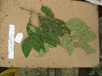 904007[]Weiblen, G.D. GW26682005-10-15 Papua New Guinea, Chimbu, Mu Village, near Kundiawa, -6.083333 145.033333, 2000m |
MIN:Plants | 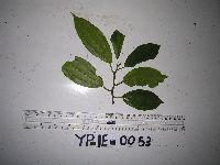 951578[1299048]Weiblen, G.D. YP1E00532012-05-11 Papua New Guinea, Morobe, Yawan Village, -6.164067 146.83985, 1719m |
MIN:Plants | 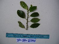 951579[1299047]Weiblen, G.D. YP3A23402010-10-26 Papua New Guinea, Morobe, Yawan Village, -6.162617 146.841967, 1777m |
MIN:Plants | 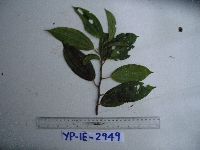 951580[1299046]Weiblen, G.D. YP1E29492012-05-10 Papua New Guinea, Morobe, Yawan Village, -6.164067 146.83985, 1719m |
MIN:Plants | 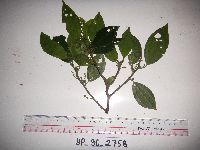 951590[1299036]Weiblen, G.D. YP3C27582012-04-04 Papua New Guinea, Morobe, Yawan Village, -6.163017 146.842983, 1732m |
MIN:Plants | 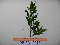 951600[1299027]Weiblen, G.D. YP2A00982010-10-07 Papua New Guinea, Morobe, Yawan Village, -6.162617 146.841967, 1777m |
MIN:Plants | 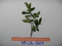 951601[1299026]Weiblen, G.D. YP2A01092010-10-07 Papua New Guinea, Morobe, Yawan Village, -6.162617 146.841967, 1777m |
MIN:Plants | 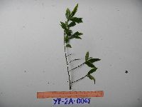 951612[1299016]Weiblen, G.D. YP2A00612010-10-13 Papua New Guinea, Morobe, Yawan Village, -6.162617 146.841967, 1777m |
MIN:Plants | 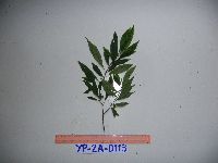 951613[1299015]Weiblen, G.D. YP2A01132010-10-15 Papua New Guinea, Morobe, Yawan Village, -6.162617 146.841967, 1777m |
MIN:Plants | 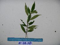 951616[1299012]Weiblen, G.D. YS2G01812010-11-29 Papua New Guinea, Morobe, Yawan Village, -6.1631 146.840217, 1752m |
MIN:Plants | 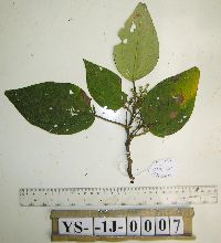 951737[1299288]Weiblen, G.D. YS1J00072012-06-20 Papua New Guinea, Morobe, Yawan Village, -6.164683 146.841717, 1855m |
MIN:Plants | 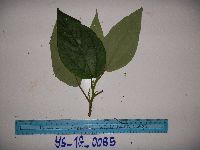 951738[1299287]Weiblen, G.D. YS1G00852010-11-23 Papua New Guinea, Morobe, Yawan Village, -6.1631 146.840217, 1752m |
MIN:Plants | 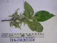 951739[1299286]Weiblen, G.D. YS4H01242012-09-24 Papua New Guinea, Morobe, Yawan Village, -6.1641 146.843567, 1851m |
MIN:Plants | 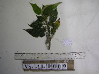 951750[1297950]Weiblen, G.D. YS1J00092012-06-18 Papua New Guinea, Morobe, Yawan Village, -6.164683 146.841717, 1855m |
MIN:Plants | 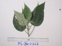 951751[1297949]Weiblen, G.D. YS3G03432011-01-19 Papua New Guinea, Morobe, Yawan Village, -6.1631 146.840217, 1752m |
MIN:Plants | 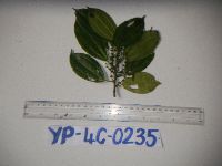 951840[1297893]Weiblen, G.D. YP4C02352012-04-23 Papua New Guinea, Morobe, Yawan Village, -6.163017 146.842983, 1732m |
MIN:Plants | Cecropia NULL 904139[] GW2794 Panama |
MIN:Plants | 927208[]Barriga, Paola 2009-0592009-00-00 Peru, Madre de Dios, Los Amigos Biological Station |
MIN:Plants | 927210[]Barriga, Paola 2009-1542009-02-14 Peru, Madre de Dios, Los Amigos Biological Station; airport; 100m from techo on the side of the airstrip with a trail, 20m off trail |
MIN:Plants | Cecropia peltata NULL 939730[]Perez, D. 792011-07-07 Costa Rica, Guanacaste, Liberia, Area de Conservacion Guanacaste, Sector Santa Rosa, Sendero Indio Desnudo, 10.84 -85.61, 320m |
MIN:Plants | Parietaria pensylvanica Muhlenberg ex Willdenow 492040[]Monson, Paul PHM65121992-07-10 United States, Minnesota, Lake, Lake County, Palisade Head. T56N R7W Sec 22. Ca. 5 mi NE of Silver Bay. Climbing theatre.;North Shore / Palisade Head;056N;07W;22, 47.32413 -91.213641 |
MIN:Plants | Parietaria pensylvanica Muhlenberg ex Willdenow 920618[]Smith, Welby 183871990-09-13 United States, Minnesota, Morrison, Camp Ripley Military Reservation. Camp Ripley Military Reservation. Morrison County...About 2 km NW of Crow Wing Lake...floodplain of the Mississippi River...UTM: 394500E 5122500N. T 132 R 29 SW1/4 of NW1/4 of Sec 17. 132N 29W 17, 46.2497222 -94.3686111 |
MIN:Plants | Parietaria pensylvanica Muhlenberg ex Willdenow 264333[]Holzinger, John s.n.1895-06-19 United States, Minnesota, Winona, Devils Cave, Winona Co.;;N;;, 44.049963 -91.639315 |
MIN:Plants | Parietaria pensylvanica Muhlenberg ex Willdenow 264334[]Holzinger, John s.n.1901-07-00 United States, Minnesota, Winona, Winona Co.;;N;;, 43.98685 -91.779129 |
MIN:Plants | Parietaria pensylvanica Muhlenberg ex Willdenow 454592[]Lee, Michael MDL27752000-06-22 United States, Minnesota, Stearns, Stearns County ... On the southeast shore of Big Birch Lake seven miles north-northeast of Melrose ... T127N R32W SE1/4 of SE1/4 Sec. 31, SW1/4 of SW1/4 Sec. 32. 127N 32W 31&32, 45.766774 -94.756998 |
MIN:Plants | Parietaria pensylvanica Muhlenberg ex Willdenow 903817[]Lee, Michael MDL40162005-07-01 United States, Minnesota, Todd, Todd County...On large peninsula into the eastern shore of McCarrahan Lake, 2.5 miles southwest of Long Prairie... western end of peninsula...T129N R34W SW1/4 of SW1/4 of NW1/4 Sec. 25. 129N 34W 25, 45.954492 -94.907707 |
MIN:Plants | Parietaria pensylvanica Muhlenberg ex Willdenow 264346[]Holzinger, John s.n.1901-07-00 United States, Minnesota, Winona, Winona Co.;;N;;, 43.98685 -91.779129 |
MIN:Plants | Parietaria pensylvanica Muhlenberg ex Willdenow 369393[]Moore, John; et al. 142021941-06-13 United States, Minnesota, Clay, Hwy 75, 3.5 mi N of Moorhead;;;;, 46.92452 -96.767581 |
MIN:Plants | Parietaria pensylvanica Muhlenberg ex Willdenow 370209[]Moore, John; et al. 142151941-06-13 United States, Minnesota, Norman, Red River, beside hwy 75, 1 mi W of Perley;;;;, 47.237588 -96.832946 |
MIN:Plants | Parietaria pensylvanica Muhlenberg ex Willdenow 370754[]Moore, John; et al. 133281940-06-27 United States, Minnesota, Redwood, Ca. 7 mi S of Sacred Heart, Redwood Co.;;114N;37W;, 44.315321 -95.2333 |
MIN:Plants | Parietaria pensylvanica Muhlenberg ex Willdenow 371057[]Moore, John 130811940-06-20 United States, Minnesota, Yellow Medicine, S side of Granite Falls;;N;;, 44.808253 -95.557591 |
MIN:Plants | Parietaria pensylvanica Muhlenberg ex Willdenow 381185[]Moore, John; et al. 153201942-06-19 United States, Minnesota, Steele, Straight River, bridge at N end of Medford, Medford Twp, NE 1/4, section. Steele Co.;;108N;20W;, 44.180211 -93.244574 |
MIN:Plants | Parietaria pensylvanica Muhlenberg ex Willdenow 381500[]Moore, John; et al. 153991942-06-20 United States, Minnesota, Olmsted, 1 mi N of Rochester on hwy 63. Olmsted Co.;;;;, 44.03615 -92.46972 |
MIN:Plants | Parietaria pensylvanica Muhlenberg ex Willdenow 383081[]Moore, John 157581943-06-18 United States, Minnesota, Dakota, N shore of Lake Rebecca, Hastings;;N;;, 44.75045 -92.869225 |
MIN:Plants | Parietaria pensylvanica Muhlenberg ex Willdenow 383542[]Moore, John 158731943-06-30 United States, Minnesota, Dakota, Chub Lake, Dakota Co.;;113N;20W;, 44.565114 -93.217816 |
MIN:Plants | Parietaria pensylvanica Muhlenberg ex Willdenow 386071[]Moyle, J. 39541945-07-27 United States, Minnesota, Chippewa, Chippewa Co. Watson;;118N;41W;, 45.00968 -95.801418 |
MIN:Plants | Parietaria pensylvanica Muhlenberg ex Willdenow 421378[]Jacobs, D. 5611948-08-13 United States, Minnesota, Nicollet, 4 mi W of Courtland, Nicollet co.;;110N;30W;, 44.315453 -94.417028 |
MIN:Plants | Parietaria pensylvanica Muhlenberg ex Willdenow 428291[]Dunevitz, H. 3351990-07-31 United States, Minnesota, Goodhue, Goodhue Co.; two miles west of Cannon Falls above south shore of Lake Byllesby Reservoir; T 112N R 18W NE1/4 of SW1/4 of Goodhue Co.; two miles west of Cannon Falls above south shore of Lake Byllesby Reservoir; T 112N R 18W NE1/4 of SW1/4 of Sec 14. 112N 18W 14, 44.505759 -92.951821 |
MIN:Plants | Parietaria pensylvanica Muhlenberg ex Willdenow 437383[]Moore, John; Moore, Marjorie 162111944-05-26 United States, Minnesota, Dakota, Four Corners, Dakota Co.;;113N;17W;9, 44.608261 -92.864268 |
MIN:Plants | Parietaria pensylvanica Muhlenberg ex Willdenow 444702[]Moore, John; Huff, N. 180021945-07-25 United States, Minnesota, Morrison, Along rr right of way at Center Valley;;N;;, 46.020807 -94.281229 |
MIN:Plants | Parietaria pensylvanica Muhlenberg ex Willdenow 444867[]Moore, John; Huff, N. 195951947-06-18 United States, Minnesota, Kandiyohi, N of lake, Sibley State Park;Sibley State Park;N;;, 45.319687 -95.02307 |
MIN:Plants | Parietaria pensylvanica Muhlenberg ex Willdenow 446120[]Moore, John; Huff, N. 196401947-06-19 United States, Minnesota, Swift, Monson Lake State Memorial Park, Swift Co.;Monson Lake State Park;121N;37W;, 45.3167 -95.2667 |
MIN:Plants | Parietaria pensylvanica Muhlenberg ex Willdenow 446313[]Moore, John; Huff, N. 187031946-06-20 United States, Minnesota, Pipestone, Pipestone Co.; near the stone quarry at Pipestone;Pipestone National Monument;106N;46W;, 44.013519 -96.324755 |
MIN:Plants | Parietaria pensylvanica Muhlenberg ex Willdenow 446567[]Moore, John; Huff, N. 184241946-06-07 United States, Minnesota, Le Sueur, Le Sueur Co. Along the N arm of Lake Elysian;;109N;24W;30, 44.198577 -93.673838 |
MIN:Plants | Parietaria pensylvanica Muhlenberg ex Willdenow 448387[]Moore, John; Huff, N. 189541946-08-03 United States, Minnesota, Benton, Along the S bank of May Hew Creek, 5 mi E of East St. Cloud;;N;;, 45.608364 -93.93811 |
MIN:Plants | Parietaria pensylvanica Muhlenberg ex Willdenow 448927[]Moore, John; Hall, Robert 163901944-06-10 United States, Minnesota, Pipestone, Pipestone Co.; Pipestone quarry;Pipestone National Monument;106N;46W;, 44.013519 -96.324755 |
MIN:Plants | Parietaria pensylvanica Muhlenberg ex Willdenow 449030[]Moore, John 166561944-06-30 United States, Minnesota, Washington, Washington Co.; 1 mi west of Marine;;031N;20W;, 45.200339 -92.771359 |
MIN:Plants | Parietaria pensylvanica Muhlenberg ex Willdenow 449113[]Moore, John 169541945-05-30 United States, Minnesota, Watonwan, S fork of the Watonwan River, 5 mi E of St. James;;106N;31W;, 44.052475 -94.515445 |
MIN:Plants | Parietaria pensylvanica Muhlenberg ex Willdenow 464303[]Gerdes, Lynden 26781998-06-11 United States, Minnesota, Cook, T65N R01W S33NWSW. Cook Co.; Superior National Forest. West facing cliff area overlooking the NE portion of Moss Lake.;Boundary Waters Canoe Area Wilderness / Superior National Forest;065N;01W;33, 48.069999 -90.459509 |
MIN:Plants | Parietaria pensylvanica Muhlenberg ex Willdenow 497434[]Moore, John 201511949-06-16 United States, Minnesota, Cottonwood, 13 mi S of Sanborn;;N;;, 44.021397 -95.128604 |
MIN:Plants | Parietaria pensylvanica Muhlenberg ex Willdenow 507273[]Moore, John 207231950-06-22 United States, Minnesota, Faribault, 2 mi NW of Blue Earth;;N;;, 43.657936 -94.130487 |
MIN:Plants | Parietaria pensylvanica Muhlenberg ex Willdenow 507305[]Moore, John 207571950-06-23 United States, Minnesota, Mower, Along the Red Cedar River 2.5 mi W of Lyle;;N;;, 43.503365 -93.001362 |
MIN:Plants | Parietaria pensylvanica Muhlenberg ex Willdenow 508364[]Smith, Welby 170761990-06-27 United States, Minnesota, Martin, Martin Co. Bright Lake County Park, about 2.5 mi NE of Ceylon; T101N R31W SW1/4 of NE1/4 of Sec 17;;101N;31W;17, 43.5533333 -94.7047195 |
MIN:Plants | Parietaria pensylvanica Muhlenberg ex Willdenow 514949[]Scott, P. 9141996-08-20 United States, Minnesota, Cook, Cook Co. Daniels Palisades at W end of Daniels Lake T65N R1W sec.27 SWSWSE.;Boundary Waters Canoe Area Wilderness / Superior National Forest;065N;01W;27, 48.084492 -90.442077 |
MIN:Plants | Parietaria pensylvanica Muhlenberg ex Willdenow 519348[]Scott, P. 10151997-08-13 United States, Minnesota, Cook, Cook Co. Ledges of WSW facing cliff by Moss Lake T65N R1W sec.33 NWNWSW.;Boundary Waters Canoe Area Wilderness / Superior National Forest;065N;01W;33, 48.069999 -90.459509 |
MIN:Plants | Parietaria pensylvanica Muhlenberg ex Willdenow 542525[]Moore, John 218281954-07-20 United States, Minnesota, Wilkin, 2 1/2 mi S of Breckenridge;;N;;, 46.227375 -96.588129 |
MIN:Plants | Parietaria pensylvanica Muhlenberg ex Willdenow 550202[]Moore, John; et al. 222821954-09-22 United States, Minnesota, Lincoln, Island at NE end of Lake Benton;;110N;45W;25, 44.302569 -96.218568 |
MIN:Plants | Parietaria pensylvanica Muhlenberg ex Willdenow 553848[]Moore, John 224671955-05-31 United States, Minnesota, Sibley, Along the W shore of High Island Lake at New Auburn;;114N;28W;, 44.6773 -94.2189 |
MIN:Plants | Parietaria pensylvanica Muhlenberg ex Willdenow 558191[]Moore, John 237711958-06-10 United States, Minnesota, Kittson, 5 mi W of Karlstad;;N;;, 48.577425 -96.629968 |
MIN:Plants | Parietaria pensylvanica Muhlenberg ex Willdenow 558398[]Moore, John; Hsi, Yu-tseng [Eugene] 233941957-08-07 United States, Minnesota, Blue Earth, Along the river at Mankato Springs; Sec. 29 SW1/4 Le Ray Twp.;;108N;25W;29, 44.130505 -93.978801 |
MIN:Plants | Parietaria pensylvanica Muhlenberg ex Willdenow 585439[]Moore, John 262891963-05-24 United States, Minnesota, Blue Earth, near top of N facing bluffs 1 1/2 mi W of Mankato;;N;;, 44.16233 -94.060637 |
MIN:Plants | Parietaria pensylvanica Muhlenberg ex Willdenow 585592[]Moore, John 263231963-06-06 United States, Minnesota, Houston, at Caledonia;;;;, 43.634691 -91.496808 |
MIN:Plants | Parietaria pensylvanica Muhlenberg ex Willdenow 592301[]Westkaemper, Remberta s.n.1964-07-00 United States, Minnesota, Stearns, Stearns Co. St. Joseph, St. Benedict College campus;;124N;29W;, 45.564772 -94.317966 |
MIN:Plants | Parietaria pensylvanica Muhlenberg ex Willdenow 602169[]Westkaemper, Remberta s.n.1965-07-00 United States, Minnesota, Stearns, Stearns Co. St. Cloud Hospital;;;;, 45.557693 -94.1603 |
MIN:Plants | Parietaria pensylvanica Muhlenberg ex Willdenow 645951[]Westkaemper, Remberta s.n.1968-07-00 United States, Minnesota, Stearns, Stearns Co. SBC [St. Benedict's College], St. Joseph;;124N;29W;, 45.564772 -94.317966 |
MIN:Plants | Parietaria pensylvanica Muhlenberg ex Willdenow 657158[]Scanlan, M. 0591973-06-13 United States, Minnesota, Swift, Swift Co. SW-104 (S12, T122N, R40W);;T122N R40W S12, 45.390752 -95.634201 |
MIN:Plants | Parietaria pensylvanica Muhlenberg ex Willdenow 707899[]Smith, Welby 12181979-08-02 United States, Minnesota, Redwood, Redwood Co. 6.5 mi NNE of Morgan, S of Wabasha Creek and N of co. hwy 10; T112N r34W NW1/4 SE1/4 Sec. 14;;112N;34W;14, 44.513365 -94.889882 |
MIN:Plants | Parietaria pensylvanica Muhlenberg ex Willdenow 711418[]Smith, Welby 9941979-06-26 United States, Minnesota, Nicollet, Nicollet Co. 3.2 mi W of Courtland, on S side of st. hwy 14; T110N R30W NE1/4 SE1/4 Sec. 35;;110N;30W;35, 44.290079 -94.401883 |
MIN:Plants | Parietaria pensylvanica Muhlenberg ex Willdenow 721319[]Lustig, K. 6761979-07-11 United States, Minnesota, Sherburne, Clear Lake-Mississippi Scenic and Recreational River SNA, 12 mi SE of St. Cloud; T34N R30W;Clear Lake Scientific Natural Area;034N;30W;, 45.429169 -94.042303 |
MIN:Plants | Parietaria pensylvanica Muhlenberg ex Willdenow 728605[]Lustig, K. 8231979-08-08 United States, Minnesota, Sherburne, Mississippi River Islands Scientific Natural Area. Sherburne & Wright Cos. ...Mississippi Scenic and Recreational River Islands SNA: Mississippi River Islands between Monticello and Elk River, Sec. 2, 3, 4, T32N, R26, 27W; Sec. 7, 9, 18, T121N, R23, 24W.. 032N 26W 3, 45.29348 -93.55625 |
MIN:Plants | Parietaria pensylvanica Muhlenberg ex Willdenow 728606[]Lustig, K. 7351979-07-12 United States, Minnesota, Sherburne, Mississippi River Islands Scientific Natural Area. Sherburne & Wright Cos. ...Mississippi Scenic and Recreational River Islands SNA: Mississippi River Islands between Monticello and Elk River, Sec. 2, 3, 4, T32N, R26, 27W; Sec. 7, 9, 18, T121N, R23, 24W.. 032N 26W 3, 45.29348 -93.55625 |
MIN:Plants | Parietaria pensylvanica Muhlenberg ex Willdenow 737261[]Kachman, R. 3361980-08-03 United States, Minnesota, Dodge, Tombstones at the eastern edge of Hillside Cemetery, cemetery ca. 1 mi S of Claremount;;N;;, 44.035764 -93.004974 |
MIN:Plants | Parietaria pensylvanica Muhlenberg ex Willdenow 739673[]Moyer, Lycurgus s.n.1895-08-13 United States, Minnesota, Pope, Lake Minnewaska;;N;;, 45.617836 -95.450645 |
MIN:Plants | Parietaria pensylvanica Muhlenberg ex Willdenow 741157[]Converse, C. 10441982-06-08 United States, Minnesota, Pope, Ordway Prairie; T123N R36W SE1/4 SE1/4 Sec. 19;Ordway Prairie, The Nature Conservancy;123N;36W;19, 45.434262 -95.245019 |
MIN:Plants | Parietaria pensylvanica Muhlenberg ex Willdenow 743929[]Ownbey, Gerald 66041980-08-23 United States, Minnesota, Winona, Winona Co. Queens Bluff, Rte 61, ca 12 mi SE of Winona, W side;Great River Bluffs State Park;106N;05W;, 43.946353 -91.399309 |
MIN:Plants | Parietaria pensylvanica Muhlenberg ex Willdenow 745480[]Smith, Welby 45381981-06-28 United States, Minnesota, Wright, Wright Co.; wayside park on the W side of Co Hwy 75 in Clearwater. SW1/4 NW1/4 S35, T123N, R27W;;123N;27W;35, 45.416899 -94.04856 |
MIN:Plants | Parietaria pensylvanica Muhlenberg ex Willdenow 750416[]Almendinger, J. 53081982-08-14 United States, Minnesota, Becker, Becker Co. 2.8 mi E of Pine Point, SW of NE of S2, T140N, R37W;;140N;37W;2, 46.972452 -95.317709 |
MIN:Plants | Parietaria pensylvanica Muhlenberg ex Willdenow 751017[]Galatowitsch, S. 8951983-08-13 United States, Minnesota, Wabasha, NE1/4 NE1/4 S6, T109N, R9W;;T109N R09W S6, 44.272608 -91.938982 |
MIN:Plants | Parietaria pensylvanica Muhlenberg ex Willdenow 758289[]Delaney, B. s.n.1982-07-14 United States, Minnesota, Isanti, along trail branching W off trail to Corniea's Cabin; SW1/4 S22;Cedar Creek National History Area;034N;23W;22, 45.417262 -93.198272 |
MIN:Plants | Parietaria pensylvanica Muhlenberg ex Willdenow 800348[]Cholewa, A. 16901989-06-21 United States, Minnesota, Washington, Carpenter Nature Center. Washington Co, T26N R20W Upper bluff trail, E of administration Building, just S of footbridge;Carpenter Nature Center;026N;20W;04, 44.768259 -92.812758 |
MIN:Plants | Parietaria pensylvanica Muhlenberg ex Willdenow 812670[]Wheeler, Gerald 121911988-09-11 United States, Minnesota, Big Stone, Barry Lake Wildlife Management Area. Big Stone Co.; Ca. 1.2 mi NW of Barry, ca. 0.7 mi E of rte 57, adjacent to Barry Lake; W1/2 SE1/4 NE1/4 Sec. 8 T124N R47W (Toqua Twp.). 124N 47W 8, 45.567133 -96.579895 |
MIN:Plants | Parietaria pensylvanica Muhlenberg ex Willdenow 834025[]Smith, Welby 159031989-07-25 United States, Minnesota, Freeborn, Freeborn County..In Arrowhead Point County Park, on Freeborn Lake, about 4 mi N of Alden. NE1/4 SW1/4 sec 11, T103N R23W;Arrowhead Point County Park;103N;23W;11, 43.738067 -93.558355 |
MIN:Plants | Parietaria pensylvanica Muhlenberg ex Willdenow 834034[]Smith, Welby 154951989-06-27 United States, Minnesota, Anoka, Anoka Co. About 2 mi SW of Linwood; N side of Devil Lake. SE1/4 SW1/4 sec.14, T33N R23W;;033N;23W;14, 45.3427773 -93.1772232 |
MIN:Plants | Parietaria pensylvanica Muhlenberg ex Willdenow 834356[]Smith, Welby 153901989-06-14 United States, Minnesota, Chisago, Chisago Co. In the St. Croix Valley, about 5 mi S-SW of Taylors Falls. NW1/4 NW1/4 sec 22 T33N R19W;;033N;19W;22, 45.3283348 -92.7125015 |
MIN:Plants | Parietaria pensylvanica Muhlenberg ex Willdenow 99810[]Rosendahl, C.; et al. 4016a1921-06-17 United States, Minnesota, Yellow Medicine, Granite Falls;;;;, 44.81 -95.54528 |
MIN:Plants | Parietaria pensylvanica Muhlenberg ex Willdenow 99869[]Holzinger, John s.n.1886-06-00 United States, Minnesota, Winona, Winona Co.;;N;;, 43.98685 -91.779129 |
MIN:Plants | Parietaria pensylvanica Muhlenberg ex Willdenow 99870[]Anonymous 25591885-08-00 United States, Minnesota, Winona, Winona Co.;;N;;, 43.98685 -91.779129 |
MIN:Plants | Parietaria pensylvanica Muhlenberg ex Willdenow 99871[]Lyon, H. 1911899-07-06 United States, Minnesota, Houston, Crooked Creek;Dorer Memorial Hardwood State Forest;;;, 43.592621 -91.284352 |
MIN:Plants | Parietaria pensylvanica Muhlenberg ex Willdenow 99872[]Sheldon, Edmund S7921891-07-00 United States, Minnesota, Brown, Sleepy Eye;;N;;, 44.297183 -94.72415 |
MIN:Plants | Parietaria pensylvanica Muhlenberg ex Willdenow 99873[]Taylor, B. T4131891-06-00 United States, Minnesota, Waseca, Buffalo Lake;;N;;, 44.057215 -93.721838 |
MIN:Plants | Parietaria pensylvanica Muhlenberg ex Willdenow 99875[]Herrick, C. s.n.1878-06-28 United States, Minnesota, Hennepin, Minneapolis;;;;, 44.979965 -93.263836 |
MIN:Plants | Parietaria pensylvanica Muhlenberg ex Willdenow 99876[]Sandberg, John s.n.1890-06-00 United States, Minnesota, Hennepin, [no further data];;;;, 45 -93.47 |
MIN:Plants | Parietaria pensylvanica Muhlenberg ex Willdenow 99877[]Sheldon, Edmund s.n.1895-05-00 United States, Minnesota, Ramsey, Ramsey Co.;;;;, 45.016016 -93.094318 |
MIN:Plants | Parietaria pensylvanica Muhlenberg ex Willdenow 99878[]Sheldon, Edmund s.n.1895-06-00 United States, Minnesota, Hennepin, Prospect Park, Minneapolis;;N;;, 44.979965 -93.263836 |
MIN:Plants | Parietaria pensylvanica Muhlenberg ex Willdenow 99879[]Ballard, C. B9851892-06-00 United States, Minnesota, Nicollet, Swan Lake, Nicollet Co.;;;;, 44.30887 -94.262002 |
MIN:Plants | Parietaria pensylvanica Muhlenberg ex Willdenow 99880[]Ballard, C. B9851892-06-00 United States, Minnesota, Nicollet, Nicollet;;109N;28W;, 44.276077 -94.187463 |
MIN:Plants | Parietaria pensylvanica Muhlenberg ex Willdenow 99881[]Rosendahl, C. 5321902-06-17 United States, Minnesota, Houston, Spring Grove;;101N;07W;, 43.543165 -91.672028 |
MIN:Plants | Parietaria pensylvanica Muhlenberg ex Willdenow 99882[]Skinner, S. 2111902-06-23 United States, Minnesota, Jackson, bluff along Des Moines R, Heron Lake Region;;;;, 43.794959 -95.320276 |
MIN:Plants | Parietaria pensylvanica Muhlenberg ex Willdenow 99883[]Skinner, S. 2201902-06-25 United States, Minnesota, Jackson, Heron Lake Region;;;;, 43.794959 -95.320276 |
MIN:Plants | Parietaria pensylvanica Muhlenberg ex Willdenow 99884[]Ballard, C. B4071891-07-00 United States, Minnesota, Scott, Jordan, Scott Co.;;114N;23W;, 44.66532 -93.627759 |
Google Map
Google Maps is a web mapping service provided by Google that features a map that users can pan (by dragging the mouse) and zoom (by using the mouse wheel). Collection points are displayed as colored markers that when clicked on, displays the full information for that collection. When multiple species are queried (separated by semi-colons), different colored markers denote each individual species.