University of Minnesota
http://www.umn.edu/
612-625-5000
http://www.umn.edu/
612-625-5000
Minnesota Biodiversity Atlas
Bell Museum
Dataset: MIN-Plants
Taxa: Astragalus
Search Criteria: excluding cultivated/captive occurrences
Bell Museum plants | |
 MIN:Plants |  539866[1074853]Tester, John s.n.1957-07-15 United States, Minnesota, Mahnomen, 3-4 miles w. and 1 mile s. of Waubun. ;Waubun Prairie Wildlife Management Area / White Earth Indian Reservation;143N;42W;33, 47.1589041 -96.0074302 |
MIN:Plants |  Astragalus neglectus (Torrey & A. Gray) E. Sheldon 910711[1075494]Rowe, Erika ERR2362007-08-08 United States, Minnesota, Hubbard, Hubbard County...Crow Wing River; 8 miles ESE of Park Rapids...T140N R33W NWNW S32;;140N;33W;32, 46.9027778 -94.8894444 |
MIN:Plants | 478976[1075371]Harris, Fred United States, Minnesota, Yellow Medicine, Detailed locality information protected. This is typically done to protect rare or threatened species localities. |
MIN:Plants |  Astragalus neglectus (Torrey & A. Gray) E. Sheldon 438343[1075492]Rowe, Erika ERR1482005-08-12 United States, Minnesota, Mahnomen, White Earth Indian Reservation / White Earth State Forest. Mahnomen County...1.2 miles west of Cty Hwy 4; 3.8 miles north of Becker/Mahnomen border...along north side of Spider Lake...1/4NE 1/4NE S18 T143N R39W. 143N 39W 18, 47.2013699 -95.6682158 |
MIN:Plants |  Astragalus whitneyi A. Gray 236041[1075545]Congdon, J. s.n.1894-08-21 United States, California, Tuolumne, Summit Mt. Warren;Yosemite National Park |
MIN:Plants |  Astragalus neglectus (Torrey & A. Gray) E. Sheldon 905653[1075475]Lee, Michael MDL40492005-07-27 United States, Minnesota, Becker, White Earth Indian Reservation / White Earth State Forest. Becker County...9.5 miles north-northwest of Ponsford...south-facing slope that forms shore of Back of the Moon Lake...T142N R38W SW1/4 of SW1/4 of SE1/4 Sec. 22; NE1/4 of NE1/4 Sec. 27...UTM's: 5218530N 312067E, 5318322N 312643E. 142N 38W 0, 47.0861101 -95.4769517 |
MIN:Plants |  912333[1074994]Smith, Welby 229181993-07-14 United States, Minnesota, Sibley, Sibley County ... Between TH 19 and the adjacent railroad tracks, about 4 miles west of Gaylord ... T112N R29W NE1/4 of NE1/4 of Sec 4. 112N 29W 4, 44.5427778 -94.3116667 |
MIN:Plants |  Astragalus purshii Douglas 491008[1122632]Schaaf, J. s.n.1983-07-04 United States, Nevada, Washoe, Steamboat Springs, Washoe Co., 1408m |
MIN:Plants |  Astragalus adsurgens var. robustior von Pallas 455734[1074692]Wheeler, Gerald 171991997-08-13 United States, Minnesota, Swift, Swift Co.; Ca. 11.5 mi. NNE of Appleton, E of Rte. 7; NE1/4 SW1/4 Sec. 21 T122N R42W (Fairfield 21);;122N;42W;21, 45.3622732 -95.9424291 |
MIN:Plants |  Astragalus bolanderi A. Gray 236039[1074851]Congdon, J. s.n.1890-08-21 United States, California, Mariposa, Mt. Hoffman, Mariposa County;Yosemite National Park;;;, 37.84691 -119.51054 |
MIN:Plants |  134252[1000365]Baker, C.; et al. 561898-06-22 United States, Colorado, Montezuma, Mancos |
MIN:Plants | 908340[]Smith, Welby 311232008-08-14 United States, Minnesota, Le Sueur, north end of Lake Pepin about 2 mi north-northwest of Montgomery...NW1/4 of NW1/4 of Sec;;112N;23W;33, 44.4691667 -93.6019444 |
MIN:Plants |  474327[1075048]Schimpf, D. DJS3192001-07-31 United States, Minnesota, Saint Louis, St. Louis County, Hoyt Lakes. T59n R14W SE1/4 of SE1/4 Sec. 20; mine haul roads where they intersect Hwy 666 at S edge of mine area N of Hoyt Lakes.. 059N 14W 20, 47.5750008 -92.1416702 |
MIN:Plants |  Astragalus agrestis Douglas ex G. Don 461971[1074822]Wheeler, Gerald 171711997-08-12 United States, Minnesota, Swift, Swift County ... Ca.10 mi.N of Appleton, NE margin of Rev Marsh ... N1/2 NE1/4 NE1/4 Sec.28 T122N R43W (Hegbert 28);;122N;43W;28, 45.3483129 -96.0667542 |
MIN:Plants |  435828[1074946]Judziewicz, E. 106631993-06-22 United States, Minnesota, Pine, Saint Croix State Park. Pine Co.; St. Croix State Park. T39N-R19W, Sec. 9, SW; at the campground at the first confluence of the Kettle and St. Croix Rivers.. 039N 19W 9, 45.8832437 -92.7273241 |
MIN:Plants |  482296[1075099]Wheeler, Gerald 159061997-06-06 United States, Minnesota, Brown, Brown Co.; Ca. 15 mi. NW of Sleepy Eye, 0.4 mi. NE of Rte. 10, Morgan Sportsman Club Recreation Area; SW1/4 NE1/4 SW1/4 Sec. 19 T112N R33W (Eden 19). 112N 33W 19, 44.4897701 -94.8570391 |
MIN:Plants |  910927[1074879]Smith, Welby 219811992-09-07 United States, Minnesota, Watonwan, Watline Wildlife Management Area. Watonwan County...Watline State Wildlife Management Area, about 2 miles southwest of S. James...T 106N R 32W NW1/4 of NE1/4 of Sec 34. 106N 32W 34, 43.9463889 -94.6686111 |
MIN:Plants |  561049[1074690]Kiefer, Gretel 661998-06-01 United States, Minnesota, Douglas, Douglas Co ... Kensington- 1 mile West of Roland Lake Rd. on Mellow Ln.; T127N R40W 19 SW4;;127N;40W;19, 45.7961897 -95.7480461 |
MIN:Plants |  490717[1074878]Cully, Anne; et al. s.n.1998-08-09 United States, Minnesota, Cottonwood, Cottonwood County ... Jeffers Petroglyphs Historical Site;Jeffers Petroglyphs Historical Site;107N;35W;09, 44.0864517 -95.0499662 |
MIN:Plants |  489043[1075182]Bosch, T. 102001-05-14 United States, Minnesota, Big Stone, Approx. 0.5 mile east of Hwy. 75 and 2 miles south of Hwy. 7.;;120N;45W;01, 45.2324999 -96.2365357 |
MIN:Plants |  509879[1075007]Wheeler, Gerald 169911997-08-07 United States, Minnesota, Swift, Swift County ... Ca. 8 mi. N of Kerkhoven , at the jct. of Rte. 35 and Rte. 18 ... N1/2 NW1/4 Sec. 10 T121N R37W;;121N;37W;10, 45.3037058 -95.3063695 |
MIN:Plants |  Astragalus bolanderi A. Gray 235881[1074850]Congdon, J. s.n.1890-08-10 United States, California, Mariposa, Crescent Lake, Mariposa County;Yosemite National Park;;;, 37.56466 -119.53348 |
MIN:Plants |  Astragalus congdonii S. Watson 235880[1075055]Congdon, J. s.n.1888-05-21 United States, California, Mariposa, Hite's Cove Trail, Mariposa County...Type locality;Yosemite National Park |
MIN:Plants |  Astragalus lotiflorus Hooker 454787[1075364]Biederman, L. 0771999-05-06 United States, Minnesota, Stevens, Stevens county ... Four miles SSW of Morris ... along the Pomme de Terre River ... T124N R42W SWSE13;;124N;42W;13, 45.5497998 -95.8814656 |
MIN:Plants |  Astragalus neglectus (Torrey & A. Gray) E. Sheldon 507988[1075491]Anderson, Craig 10042000-07-12 United States, Minnesota, Becker, White Earth Indian Reservation. Becker County ... county gravel road where some work had been done a couple of years previously ... T141N R41W: 1/4 of NE1/4 of NE1/4 of Sect. 5. 141N 41W 5, 47.0570195 -95.9014099 |
MIN:Plants |  477629[1074973]Smith, Welby 172431990-07-13 United States, Minnesota, Ramsey, Ramsey County ... At the southeast end of Snail Lake, in Shoreview ... T 30N R 23W SW1/4 of SW1/4 of Sec 24;Snail Lake Vadnais Lake County Park;030N;23W;24, 45.0683327 -93.1227798 |
MIN:Plants |  Astragalus lotiflorus Hooker 478957[1075362]Wheeler, Gerald 200841999-07-16 United States, Minnesota, Nicollet, Nicollet Co.; Ca. 1.2 mi. W of Rte. 15 on Rte. 21, E of road; SW1/4 NW1/4 NW1/4 Sec. 16 T110N R30W;;110N;30W;16, 44.3334899 -94.4420242 |
MIN:Plants |  477857[1075149]Wheeler, Gerald 202151999-08-02 United States, Minnesota, Sibley, Sibley County ... Ca. 2 mi. SW of Henderson; Rush River State Wayside Park ... E1/2 SE1/4 Sec. 15 T112N R26W;;112N;26W;15, 44.5074686 -93.939321 |
MIN:Plants |  Astragalus agrestis Douglas ex G. Don 539888[1074755]Tester, John s.n.1957-07-01 United States, Minnesota, Mahnomen, 3-4 miles w. and 1 mile s. of Waubun. ;Waubun Prairie Wildlife Management Area / White Earth Indian Reservation;143N;42W;33, 47.1589041 -96.0074302 |
MIN:Plants |  Astragalus lotiflorus Hooker 476112[1075370]Wheeler, Gerald 202681999-08-03 United States, Minnesota, Sibley, Sibley Co.; Ca. 2 mi. SW of Henderson, Rush River State Wayside Park; SE1/4 SE1/4 SE1/4 Sec. 15 T112N R26W (Henderson 15;;112N;26W;15, 44.5074686 -93.939321 |
MIN:Plants |  Astragalus lentiginosus var. salinus (Howell) Barneby 794903[1075287]Schaaf, J. 1911982-08-18 United States, Nevada, Humboldt, Humboldt Co. ... US 95 MP 7-8, 1341m |
MIN:Plants |  Astragalus neglectus (Torrey & A. Gray) E. Sheldon 915854[1075538]Rowe, Erika ERR1272005-08-12 United States, Minnesota, Becker, White Earth Indian Reservation. Becker County...2.3 miles NE of White Earth on Township Road 332nd near the intersection with Township Road 346th... 1/4SE 1/4NE S13 T142N R41W. 142N 41W 13, 47.0279882 -95.8173809 |
MIN:Plants |  540015[1075101]Tester, John s.n.1957-05-22 United States, Minnesota, Mahnomen, 3-4 miles w. and 1 mile s. of Waubun. ;Waubun Prairie Wildlife Management Area / White Earth Indian Reservation;143N;42W;33, 47.1589041 -96.0074302 |
MIN:Plants |  Astragalus adsurgens var. robustior von Pallas 509725[1074675]Wheeler, Gerald 176651997-09-04 United States, Minnesota, Chippewa, Chippewa County ... Ca. 3 mi. NW of Granite Fallson Palmer Creek road ... NW1/4 NE1/4 SE1/4 Sec. 20 T116N R39W;;116N;39W;20, 44.836485 -95.5769896 |
MIN:Plants |  919383[1075049]Chayka, K. KC-10172010-07-01 United States, Minnesota, Ramsey, Ramsey County...Vadnais/Snail Lake County Park; at Sucker Lake, west side of paved taril just north of the fen;Snail Lake Vadnais Lake County Park;;;, 45.0713889 -93.0997222 |
MIN:Plants |  Astragalus lentiginosus var. diphysus M.E. Jones 794885[1075286]Schaaf, J. 1781983-06-23 United States, Nevada, White Pine, White Pine Co. ... Along Alt. US 93, WP-MP 92-112, 1859m |
MIN:Plants |  428440[1074987]Anderson, Craig 7071999-08-18 United States, Minnesota, Stevens, Stevens Co.; Mud Creek WPA; T124N R42W: NW1/4 of NE1/4 of SW1/4 of sect. 17;Mud Creek Wildlife Management Area;124N;42W;17, 45.54982 -95.96367 |
MIN:Plants |  Astragalus congdonii S. Watson 236301[1075054]Congdon, J. s.n.1892-05-08 United States, California, Mariposa, Hite's Cove, Mariposa County...Type locality;Yosemite National Park |
MIN:Plants |  920810[1074948]Smith, Welby 175991990-08-01 United States, Minnesota, Morrison, Camp Ripley Military Reservation. Camp Ripley Military Reservation. Morrison County...About 200 meters NE of the junction of Normandy Road and... Luzon Road...UTM: 384700E 5113500N. T 131N R 30W SW1/4 of SW1/4 of Sec 8. 131N 30W 8, 46.1672222 -94.4936111 |
MIN:Plants |  455708[1075062]Wheeler, Gerald 156251997-05-22 United States, Minnesota, Nicollet, Nicollet Co.; Ca. 7 mi. SE of Fort Ridgely State Park, 0.2 mi. W of Rte. 59 on Rte. 21; SW1/4 SE1/4 NW1/4 Sec. 30 T111N R31W (West Newton 30). 111N 31W 30, 44.3845348 -94.6065383 |
MIN:Plants |  Astragalus neglectus (Torrey & A. Gray) E. Sheldon 915029[1075517]Lee, Michael MDL43342006-09-06 United States, Minnesota, Becker, Greenwater Lake Scientific Natural Area / White Earth Indian Reservation. Becker County ... Greenwater Lake State Scientific & Natural Area, six miles west-northwest of Ponsford .. Northwest side of Greenwater Lake ... T141N R38W SE1/4 of NE1/4 of NW1/4 Sec.33 ... UTM: 5206924N 309935E. 141N 38W 33, 46.9838935 -95.4976994 |
MIN:Plants |  833723[1074685]Smith, Welby 140851988-05-30 United States, Minnesota, Lac Qui Parle, Lac Qui Parle County...About 3 mi west of Montevideo...ravine that drains north into the Minnesota River. NE1/4 NE1/4 section 21, T 117N R 41W. 117N 41W 21, 44.9177778 -95.8 |
MIN:Plants |  Astragalus adsurgens var. robustior von Pallas 134165[1074717]Holzinger, John s.n.1886-00-00 United States, Minnesota, Stevens, Hancock;;N;;, 45.497461 -95.796714 |
MIN:Plants |  Astragalus adsurgens var. robustior von Pallas 134166[1074716]Skinner, S. 2511892-00-00 United States, Minnesota, Jackson, West of Heron Lake region;;N;;, 43.773463 -95.329021 |
MIN:Plants |  Astragalus adsurgens var. robustior von Pallas 134167[1074709]Moyer, Lycurgus s.n.1910-06-12 United States, Minnesota, Yellow Medicine, Granite Falls;;N;;, 44.809958 -95.545575 |
MIN:Plants |  Astragalus adsurgens var. robustior von Pallas 134168[1074712]Sheldon, Edmund S74911894-06-01 United States, Minnesota, Dakota, Lakeville Lake;;N;;, 44.662818 -93.280304 |
MIN:Plants | 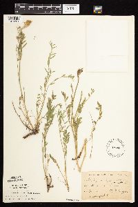 Astragalus adsurgens var. robustior von Pallas 134169[1074701]Moyer, Lycurgus s.n.1888-08-00 United States, Minnesota, Chippewa, Montevideo;;117N;40W;, 44.953148 -95.715397 |
MIN:Plants | 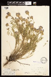 Astragalus adsurgens var. robustior von Pallas 134170[1122578]Moyer, Lycurgus s.n.1896-06-05 United States, Minnesota, Chippewa, Chippewa Co.;;N;;, 45.022344 -95.633978 |
MIN:Plants | 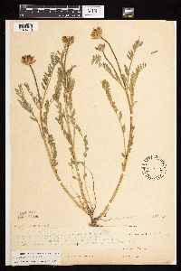 Astragalus adsurgens var. robustior von Pallas 134172[1074710]Moyer, Lycurgus 32-211886-06-04 United States, Minnesota, Chippewa, Chippewa Co.; near Magnus Peterson's; Minnesota River Bluffs, prairie throughout the greater part of Chippewa Co and Cla Chippewa Co.; near Magnus Peterson's; Minnesota River Bluffs, prairie throughout the greater part of Chippewa Co and Clara City in the E part of Co.. N , 44.769811 -95.494965 |
MIN:Plants | 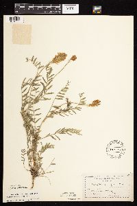 Astragalus adsurgens var. robustior von Pallas 134173[1074739]Moyer, Lycurgus 21311891-00-00 United States, Minnesota, Chippewa, Montevideo;;117N;40W;, 44.953148 -95.715397 |
MIN:Plants |  Astragalus adsurgens var. robustior von Pallas 134174[1122579]Moyer, Lycurgus s.n.1894-06-00 United States, Minnesota, Chippewa, Chippewa Co.;;N;;, 45.022344 -95.633978 |
MIN:Plants |  Astragalus adsurgens var. robustior von Pallas 134175[1074740]Sheldon, Edmund s.n.1894-06-00 United States, Minnesota, Dakota, Lakeville Lake.;;N;;, 44.662818 -93.280304 |
MIN:Plants |  Astragalus adsurgens var. robustior von Pallas 134176[1074705]Sheldon, Edmund S52781893-07-00 United States, Minnesota, Dakota, Lakeville Lake;;N;;, 44.662818 -93.280304 |
MIN:Plants |  Astragalus adsurgens var. robustior von Pallas 134177[1074737]Taylor, B. T8921891-07-00 United States, Minnesota, Pope, Glenwood;;N;;, 45.652639 -95.382892 |
MIN:Plants |  Astragalus adsurgens var. robustior von Pallas 134178[1074708]Sheldon, Edmund S34621892-08-00 United States, Minnesota, Douglas, Lake Christina;;N;;, 46.090549 -95.736412 |
MIN:Plants |  Astragalus adsurgens var. robustior von Pallas 135423[1074707]Moyer, Lycurgus s.n.1910-06-13 United States, Minnesota, Yellow Medicine, Granite Falls;;N;;, 44.809958 -95.545575 |
MIN:Plants |  Astragalus adsurgens var. robustior von Pallas 135425[1074706]Moyer, Lycurgus s.n.1910-06-12 United States, Minnesota, Yellow Medicine, Granite Falls;;N;;, 44.809958 -95.545575 |
MIN:Plants |  Astragalus adsurgens var. robustior von Pallas 159235[1074686]Puchalski, L. 2201993-06-22 United States, Minnesota, Polk, Polk Co.; Chicog WMA; S of the entrance to the WMA; T148N R45W NE1/4 of NE1/4 of Sec 33;Chicog Wildlife Management Area;148N;45W;33, 47.5937037 -96.3977888 |
MIN:Plants |  Astragalus adsurgens var. robustior von Pallas 226402[1074721]Sheldon, Edmund s.n.1892-08-01 United States, Minnesota, Douglas, Lake Christina;;N;;, 46.090549 -95.736412 |
MIN:Plants |  Astragalus adsurgens var. robustior von Pallas 278130[1074704]Roberts, Thomas s.n.1879-06-09 United States, Minnesota, Grant, Herman;;N;;, 45.809888 -96.139444 |
MIN:Plants |  Astragalus adsurgens var. robustior von Pallas 291865[1122580]Fryklund, P. s.n.1925-06-22 United States, Minnesota, Roseau, [no further data];;;;, 48.778502 -95.775574 |
MIN:Plants |  Astragalus adsurgens var. robustior von Pallas 298796[1074729]Chandonnet, Z. s.n.1912-06-17 United States, Minnesota, Becker, Detroit Lakes;;N;;, 46.805197 -95.831935 |
MIN:Plants |  Astragalus adsurgens var. robustior von Pallas 370810[1074724]Moore, John; et al. 133851940-06-28 United States, Minnesota, Nicollet, Fort Ridgely State Park. Nicollet Co.;Fort Ridgely State Park;111N;32W;, 44.443975 -94.7414917 |
MIN:Plants |  Astragalus adsurgens var. robustior von Pallas 371170[1074723]Moore, John 131581940-06-21 United States, Minnesota, Lac Qui Parle, 4 1/2 mi. N of Marietta.;;N;;, 45.073463 -96.417551 |
MIN:Plants |  Astragalus adsurgens var. robustior von Pallas 371333[1074713]Moore, John; et al. 146471941-07-06 United States, Minnesota, Pope, Pope Co. 1 mi. E of Glenwood.;;;;, 45.653598 -95.342952 |
MIN:Plants |  Astragalus adsurgens var. robustior von Pallas 371997[1074736]Moore, John; et al. 147261941-07-06 United States, Minnesota, Otter Tail, Inspiration Peak. Otter Tail Co.;Inspiration Peak Scenic Wayside Park;131N;39W;22, 46.1442542 -95.5735436 |
MIN:Plants |  Astragalus adsurgens var. robustior von Pallas 381248[1074711]Moore, John 155251942-06-27 United States, Minnesota, Clay, Campbell Beach, 6 1/2 mi. W of Hawley;;N;;, 46.880711 -96.454397 |
MIN:Plants |  Astragalus adsurgens var. robustior von Pallas 447166[1074676]Wheeler, Gerald 169631997-08-07 United States, Minnesota, Swift, Swift Co.; Ca. 12 mi. N of Murdock on rte. 33, W of road, on E-facing open hillside; SE1/4 NE1/4 Sec. 7 T122N R37W (Kerk Swift Co.; Ca. 12 mi. N of Murdock on rte. 33, W of road, on E-facing open hillside; SE1/4 NE1/4 Sec. 7 T122N R37W (Kerkhoven 7). 122N 37W 7, 45.390735 -95.3676872 |
MIN:Plants |  Astragalus adsurgens var. robustior von Pallas 458580[1074683]Puchalski, L. 1841993-05-28 United States, Minnesota, Red Lake, Red Lake Co.; on west side of county road; T 151N R 42W SE1/4 of SE1/4 of Sec 1;;151N;42W;1, 47.9277794 -95.9779827 |
MIN:Plants |  Astragalus adsurgens var. robustior von Pallas 459221[1074682]Puchalski, L. 2341993-06-23 United States, Minnesota, Polk, Polk Co.; T150N R40W SE1/4 of NE1/4 of sEc 35;;150N;40W;35, 47.7684838 -95.740675 |
MIN:Plants |  Astragalus adsurgens var. robustior von Pallas 459252[1074693]Puchalski, L. 2261993-06-23 United States, Minnesota, Polk, Polk Co.; T150N R40W NE1/4 of SE1/4 of Sec 35;;150N;40W;35, 47.7684838 -95.740675 |
MIN:Plants |  Astragalus adsurgens var. robustior von Pallas 466801[1074678]Lee, Michael MDL17351997-06-18 United States, Minnesota, Stearns, Stearns Co.; "Zimmerman Hill" two miles south-southeast of Roscoe; T122N R31W NW1/4 of NE1/4 of Sec. 6;;122N;31W;6, 45.4048553 -94.6241257 |
MIN:Plants |  Astragalus adsurgens var. robustior von Pallas 501154[1074727]Moore, John 203791949-06-29 United States, Minnesota, Roseau, 3 mi. E of Greenbush;;N;;, 48.700514 -96.1159 |
MIN:Plants |  Astragalus adsurgens var. robustior von Pallas 553959[1074728]Moore, John 225161955-06-02 United States, Minnesota, Renville, Renville Co.; Hawk Creek, 4 1/2 mi. W of Sacred Heart.;;115N;38W;, 44.791656 -95.453891 |
MIN:Plants |  Astragalus adsurgens var. robustior von Pallas 554474[1074715]Moore, John 232051957-06-14 United States, Minnesota, Pipestone, Pipestone Co.; Edge of sand pit 5 mi. northeast of Cazenovia.;;107N;46W;, 44.147582 -96.294076 |
MIN:Plants |  Astragalus adsurgens var. robustior von Pallas 560908[1074703]Ownbey, Gerald 28131959-07-10 United States, Minnesota, Norman, S18, T143N, R43W, Frenchman's Bluff ca 3.5 mi ENE of Syre;Frenchmans Bluff Scientific Natural Area;143N;43W;18, 47.2019677 -96.1838932 |
MIN:Plants |  Astragalus adsurgens var. robustior von Pallas 572595[1074731]Karol, George 255161961-06-20 United States, Minnesota, Kittson, Near Norland;;N;;, 48.776692 -96.791809 |
MIN:Plants |  Astragalus adsurgens var. robustior von Pallas 574504[1074697]Moore, John 246521959-06-18 United States, Minnesota, Pipestone, Pipestone Co.; 5 miles southeast of Ruthton;;108N;44W;, 44.109199 -96.071877 |
MIN:Plants |  Astragalus adsurgens var. robustior von Pallas 586392[1074722]Moore, John 263831963-06-20 United States, Minnesota, Pipestone, Pipestone Co.; 1 mi. east of Holland;;107N;46W;, 44.091633 -96.168476 |
MIN:Plants |  Astragalus adsurgens var. robustior von Pallas 590159[1074732]Meierotto, R. s.n.1962-08-02 United States, Minnesota, Mahnomen, Mahnomen Co. Waubun Prairie: Sec. 33, T143N, R42W;Waubun Prairie Wildlife Management Area / White Earth Indian Reservation;143N;42W;33, 47.1589041 -96.0074302 |
MIN:Plants |  Astragalus adsurgens var. robustior von Pallas 602341[1074741]Johnson, Albert s.n.1966-07-28 United States, Minnesota, McLeod, Sec. 34, SE1/4 Sumpter Twp.;;N;;, 44.778571 -94.315765 |
MIN:Plants |  Astragalus adsurgens var. robustior von Pallas 622294[1074719]Westkaemper, Remberta s.n.1971-07-01 United States, Minnesota, Stearns, Stearns Co. Lake Henry;;123N;33W;, 45.46052 -94.796398 |
MIN:Plants |  Astragalus adsurgens var. robustior von Pallas 678933[1074698]Ownbey, Gerald 49961975-07-18 United States, Minnesota, Mahnomen, Mahnomen Co. La Garde Twp, T144N, R40W, S6, NE1/4 Rte 200, 8 mi E of its jnc with Rte 59 at Mahnomen;White Earth Indian Reservation;144N;40W;6, 47.3170543 -95.7947325 |
MIN:Plants |  Astragalus adsurgens var. robustior von Pallas 720272[1074730]Heitlinger, M. 5991972-06-27 United States, Minnesota, McLeod, Schaefer Prairie, The Nature Conservancy. Schaefer Prairie: SE1/4 of Sec. 34, T115N, R29W (TNC). Along prominent N-S facing ridge on W-facing slope, near S end Schaefer Prairie: SE1/4 of Sec. 34, T115N, R29W (TNC). Along prominent N-S facing ridge on W-facing slope, near S end of the prairie.. 115N 29W 34, 44.7250496 -94.3049103 |
MIN:Plants |  Astragalus adsurgens var. robustior von Pallas 721526[1074700]Farrell, P. 631979-07-04 United States, Minnesota, Polk, Polk County...Pankratz Prairie North...7 mi SE of Crookston, S1/2 S8, T149, R45W;Pankratz Memorial Prairie, The Nature Conservancy;149N;45W;08, 47.7385174 -96.4487891 |
MIN:Plants |  Astragalus adsurgens var. robustior von Pallas 727348[1074702]Ottoson, S. 411979-06-27 United States, Minnesota, Clay, Clay County Bicentennial Prairie: Co owned, 4 mi SE of Felton, SW1/4 S5, T141N, R45W;Felton Prairie-Bicentennial Prairie Scientific Natural Area;141N;45W;5, 47.0567136 -96.4173556 |
MIN:Plants |  Astragalus adsurgens var. robustior von Pallas 729282[1074714]Heidel, B. 81-141981-06-09 United States, Minnesota, Lincoln, Hole-in-the-Mountain Preserve;Hole-in-the-Mountain Prairie, The Nature Conservancy;109N;45W;, 44.2337348 -96.291139 |
MIN:Plants |  Astragalus adsurgens var. robustior von Pallas 739601[1074735]Converse, C. 18441982-07-27 United States, Minnesota, Douglas, Staffanson Prairie: T127N, R40W, NW1/4 NE1/4 and NE1/4 NW1/4 of Sec. 18.;Staffanson Prairie, The Nature Conservancy;127N;40W;18, 45.810665 -95.7480052 |
MIN:Plants |  Astragalus adsurgens var. robustior von Pallas 739945[1074734]Converse, C. 12441982-06-22 United States, Minnesota, Douglas, Staffanson Prairie: T127N, R40W, NW1/4 NE1/4 and NE1/4 NW1/4 of Sec. 18.;Staffanson Prairie, The Nature Conservancy;127N;40W;18, 45.810665 -95.7480052 |
MIN:Plants |  Astragalus adsurgens var. robustior von Pallas 740091[1074733]Converse, C. 11501982-05-15 United States, Minnesota, Pope, Ordway Prairie: T123N, R36W, SW1/4 NW1/4 Sec. 30.;Ordway Prairie, The Nature Conservancy;123N;36W;30, 45.4342616 -95.2450181 |
MIN:Plants |  Astragalus adsurgens var. robustior von Pallas 746529[1074677]Smith, Welby 46331981-07-01 United States, Minnesota, Lac Qui Parle, Kibler Wildlife Management Area. Kibler State Wildlife Management Area, ca 2 mi WNW of the jnc of US Hwy 75 and Co Hwy 30 in Bellingham; SW1/4 NW1/4 S5, Kibler State Wildlife Management Area, ca 2 mi WNW of the jnc of US Hwy 75 and Co Hwy 30 in Bellingham; SW1/4 NW1/4 S5, T119N, R45W. 119N 45W 5, 45.1458508 -96.3181817 |
MIN:Plants |  Astragalus adsurgens var. robustior von Pallas 746533[1074725]Smith, Welby 46601981-07-02 United States, Minnesota, Clay, ca 3 mi ESE of the jnc of State Hwy 9 and Co Hwy 34 in Felton, NE1/4 SE1/4 S36, T142N, R46W;;142N;46W;36, 46.8110919 -96.4311729 |
MIN:Plants |  Astragalus adsurgens var. robustior von Pallas 746540[1074696]Smith, Welby 52201981-08-01 United States, Minnesota, Pope, Ordway Prairie, ca 1 1/2 mi N of the Pope-Kandiyohi co line, SW1/4 NE1/4 S30, T123N, R36W;Ordway Prairie, The Nature Conservancy;123N;36W;30, 45.4342616 -95.2450181 |
MIN:Plants |  Astragalus adsurgens var. robustior von Pallas 747508[1074699]Dana, R. s.n.1978-06-16 United States, Minnesota, Lincoln, Lincoln County...T109N, R45W, S19, Hole-in-the-Mountain Preserve, ca 1.5 mi S of Lake Benton;Hole-in-the-Mountain Prairie, The Nature Conservancy;109N;45W;19, 44.233753 -96.3121788 |
MIN:Plants |  Astragalus adsurgens var. robustior von Pallas 758267[1074695]Smith, Welby 74931982-08-24 United States, Minnesota, Jackson, Sangl Wildlife Management Area. Sangle State Wildlife Management Area, on the N side of Co Hwy 4, ca 1/2 mi E of its jnc with State Hwy 86; NE1/4 SW1/4 Sangle State Wildlife Management Area, on the N side of Co Hwy 4, ca 1/2 mi E of its jnc with State Hwy 86; NE1/4 SW1/4 S21, T101N, R36W. 101N 36W 21, 43.5373326 -95.1644274 |
MIN:Plants |  Astragalus adsurgens var. robustior von Pallas 758467[1074681]Smith, Welby 68461982-07-21 United States, Minnesota, Marshall, ca 9 mi NE of Middle River (town), SW1/4 S11, T158N, R42W;;158N;42W;11, 48.5218971 -96.0262242 |
MIN:Plants |  Astragalus adsurgens var. robustior von Pallas 781369[1074738]Smith, Welby 94971984-06-28 United States, Minnesota, Lyon, Prairie Marshes State Wildlife Management Area, ca. 4 mi. NNW of Russell. SE1/4 SW1/4 Sec. 36, T111N, R43W.;Prairie Marshes Wildlife Management Area;111N;43W;36, 44.3781193 -95.9681021 |
MIN:Plants |  Astragalus adsurgens var. robustior von Pallas 796004[1074694]Smith, Welby 108151985-07-19 United States, Minnesota, Mahnomen, Mahnomen Co. On the N side of Hwy. 200, about 12 mi E of Mahnomen. SE1/4 SW1/4 Sec. 35, T145N, R40W.;White Earth Indian Reservation;145N;40W;35, 47.3314314 -95.7104867 |
MIN:Plants |  Astragalus adsurgens var. robustior von Pallas 802994[1074679]Smith, Welby 117281986-06-12 United States, Minnesota, Lac Qui Parle, Lac Qui Parle County ... Antelope Hills, about 7.5 mi. due W of Providence, about 7.5 mi. due W of Providence ... SW1/4 NE1/4 Sec. 27, T116N, R45W. 116N 45W 27, 44.830555 -96.2616653 |
MIN:Plants |  Astragalus adsurgens var. robustior von Pallas 804776[1074718]Ordway, E. s.n.1976-06-29 United States, Minnesota, Pope, 4 mi. N of Starbuck, Minnewaska Twp. Sec. 6.;;N;;, 45.672324 -95.531151 |
Google Map
Google Maps is a web mapping service provided by Google that features a map that users can pan (by dragging the mouse) and zoom (by using the mouse wheel). Collection points are displayed as colored markers that when clicked on, displays the full information for that collection. When multiple species are queried (separated by semi-colons), different colored markers denote each individual species.