University of Minnesota
http://www.umn.edu/
612-625-5000
http://www.umn.edu/
612-625-5000
Minnesota Biodiversity Atlas
Bell Museum
Dataset: MIN-Plants
Taxa: Eleocharis
Search Criteria: excluding cultivated/captive occurrences
Bell Museum plants | |
 MIN:Plants | Eleocharis quinqueflora (Hartmann) O. Schwarz 453772[1020794]Schik, K. United States, Minnesota, Kittson, Detailed locality information protected. This is typically done to protect rare or threatened species localities. |
MIN:Plants | 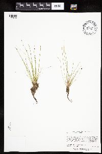 Eleocharis obtusa (Willdenow) Schultes 515502[1020426]Lee, Michael MDL38152004-08-20 United States, Minnesota, Stearns, STEARNS COUNTY ... St. John's University (Arboretum) Woods ...1 1/2 miles southwest of Collegeville ... Northeast of Sagatagan Lake ... T124N R29W NE1/4 of NE1/4 of SW1/4 Sec.6. 124N 29W 6, 45.579929 -94.373314 |
MIN:Plants | 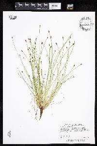 Eleocharis ovata (Roth) Roemer & Schultes 438247[1020557]Carlson, Bruce Wypt 7232005-08-02 United States, Minnesota, Saint Louis, St. Louis County ... 15.5km NE of Hoyt Lakes, 11.5km SW of Babbit, 1.4km SE of Mud Lake ...T59N R13W NENWNE 9;;059N;13W;09, 47.608137 -91.999419 |
MIN:Plants |  Eleocharis melanocarpa Torrey 251135[1020334]Umbach, L. s.n.1897-07-30 United States, Indiana, Porter, Dune Park;Indiana Dunes National Lakeshore;;;, 41.663093 -87.032128 |
MIN:Plants |  Eleocharis ovata (Roth) Roemer & Schultes 489152[1020515]Gerdes, Lynden 49522004-09-10 United States, Minnesota, Lake, Superior National Forest. T61N R08W S36SWSE. Lake County...Superior National Forest. Approximately 7.61 miles NNE of Isabella, MN. Northeast shores of Jack Lake.. 061N 08W 36, 47.721777 -91.287816 |
MIN:Plants | 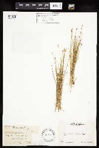 Eleocharis bolanderi A. Gray 234037[1019915]Congdon, J. s.n.1895-05-19 United States, California, Mariposa, Aqua Fria Canyon, Mariposa County;Yosemite National Park |
MIN:Plants | 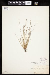 Eleocharis obtusa (Willdenow) Schultes 269128[1020455]Fassett, N.; et al. 43231927-08-24 United States, Wisconsin, Trempealeau, Trempealeau Co. ... Lakeside Park. Trempealeau;Upper Mississippi National Wildlife Refuge |
MIN:Plants | 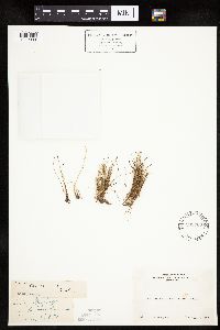 Eleocharis acicularis (Leiberg, J.B.) 233768[1019909]Congdon, J. s.n.1898-08-08 United States, California, Tuolumne, Soda Springs of the Tuolumne;Yosemite National Park |
MIN:Plants | 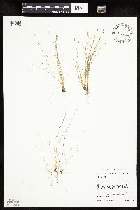 Eleocharis acicularis (Leiberg, J.B.) 480807[1019782]Schik, K. 95-3331995-08-16 United States, Minnesota, Polk, Polk Co, T151n R46W NW1/4 of the SE1/4 of S13; on CRP land.;;151N;46W;13, 47.898302 -96.493071 |
MIN:Plants | 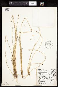 Eleocharis melanocarpa Torrey 528762[1020333]Umbach, L. 38171909-07-10 United States, Indiana, Porter, Northern Porter County ... Dune Park on Lake Michigan (7 mi. E. of Gary, Ind, SE of Chicago);Indiana Dunes National Lakeshore;;;, 41.663093 -87.032128 |
MIN:Plants |  Eleocharis obtusa (Willdenow) Schultes 510425[1020425]Wheeler, Gerald 177121997-09-05 United States, Minnesota, Renville, Renville County ... W side of Morton, Morton Outcrop complex ... SW1/4 NW1/4 NW1/4 Sec. 31 T113N R34W (Birch Cooley 31);;113N;34W;31, 44.543269 -94.990327 |
MIN:Plants |  Eleocharis ovata (Roth) Roemer & Schultes 461438[1020536]Gerdes, Lynden; et al. 26451998-06-08 United States, Minnesota, Cook, Approx. 3/4 mile NE of Mayhew Lake, beaver drainage north of the hhiking trail. NW1/4 SW1/4 of section;Boundary Waters Canoe Area Wilderness / Superior National Forest;065N;02W;26, 48.084268 -90.54412 |
MIN:Plants |  Eleocharis obtusa (Willdenow) Schultes 505389[1020421]Budelsky, R. RAB5121998-07-16 United States, Minnesota, Washington, [no further data];;030N;21W;22, 45.0722174 -92.9138983 |
MIN:Plants |  Eleocharis ovata (Roth) Roemer & Schultes 484087[1020533]Gerdes, Lynden 30011998-07-21 United States, Minnesota, Cook, Small pond, located west off Cty 47 approx. 0.25 mile southeast of it's junction with Gunflint Trail (Hwy 12). NW1/4 SE1/4 of section;Superior National Forest;065N;04W;27, 48.084242 -90.825443 |
MIN:Plants | 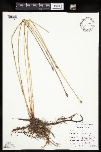 Eleocharis palustris (L.) Roemer & Schultes 461728[1020724]Mensing, D. 95-28001995-08-08 United States, Minnesota, Carlton, Carlton Co, T48N R17W NW1/4 of the SW1/4 of S35; Hay Lake.;;048N;17W;35, 46.598228 -92.459506 |
MIN:Plants |  Eleocharis acicularis (Leiberg, J.B.) 910997[1019808]Smith, Welby 245651994-07-09 United States, Minnesota, Benton, Bibles Wildlife Management Area. Benton County...Bibles State Wildlife Management Area; about 5 miles north of Santiago...T 36N R 28W SW1/4 of NW1/4 of Sec 15. 036N 28W 15, 45.6133333 -93.82 |
MIN:Plants |  Eleocharis elliptica Kunth 908466[1020040]Lee, Michael MDL43292006-08-22 United States, Minnesota, Becker, Two Inlets State Forest. Becker County...south of Two Inlets Lake, four miles south-southeast of Two Inlets...swamp northeast of One Acre Lake...T141N R36W W1/2 of NE1/4 of SE1/4 Sec. 26...UTM: 5207262N 333152E. 141N 36W 26, 46.99982 -95.201476 |
MIN:Plants | Eleocharis quinqueflora (Hartmann) O. Schwarz 908458[1020782]Myhre, K. United States, Minnesota, Cass, Detailed locality information protected. This is typically done to protect rare or threatened species localities. |
MIN:Plants | Eleocharis nitida Fernald 454435[1020341]Lee, Michael United States, Minnesota, Lake, Detailed locality information protected. This is typically done to protect rare or threatened species localities. |
MIN:Plants | Eleocharis wolfii (A. Gray) A. Gray ex Britton 476114[1020832]Harris, Fred United States, Minnesota, Renville, Detailed locality information protected. This is typically done to protect rare or threatened species localities. |
MIN:Plants |  Eleocharis palustris (L.) Roemer & Schultes 435788[1020715]Mensing, D. 95-27001995-08-16 United States, Minnesota, Carlton, Carlton Co, T46N R19W NE1/4 of the SW1/4 of S21; Moosehead Lake;;046N;19W;21, 46.45443 -92.751466 |
MIN:Plants | 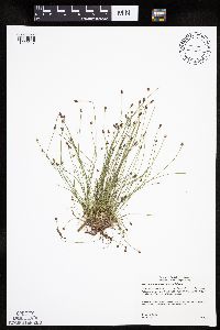 Eleocharis ovata (Roth) Roemer & Schultes 505501[1020517]Gerdes, Lynden 45042001-09-19 United States, Minnesota, Lake, North Shore / Tettegouche State Park. T57N R07W S31SENE Lake County ..Tettegouche State Park, Silver Bay, MN. Approximately 1.20 miles NNE of Nicado Lake West of creek / bridge crossing.. 057N 07W 31, 47.378845 -91.267523 |
MIN:Plants | 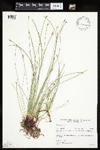 Eleocharis palustris (L.) Roemer & Schultes 483679[1020673]Gerdes, Lynden; et al. 31391998-08-11 United States, Minnesota, Cook, T65N R02W S21. Cook County; Superior National Forest. String of small islands in the southwestern portion of North Lake.;Superior National Forest;065N;02W;21, 48.100572 -90.586083 |
MIN:Plants |  Eleocharis erythropoda Steudel 489172[1020092]Lee, Michael MDL29772001-06-22 United States, Minnesota, Lake, Finland State Forest. Lake County...Along Ninemile Creek at junction of County Road 7 and the (Erie) Mining Railroad, 3/4 mile NNE of Cramer...gravel pit just east of railroad tunnel...T58N R6W SW1/4 of SE1/4 of NW1/4 Sec. 3. 058N 06W 3, 47.538429 -91.082123 |
MIN:Plants | Eleocharis quinqueflora (Hartmann) O. Schwarz 918648[1020786]Simmers, S. United States, Minnesota, Marshall, Detailed locality information protected. This is typically done to protect rare or threatened species localities. |
MIN:Plants |  Eleocharis ovata var. aphanactis John W. Moore 409177[1000904]Moore, John; Moore, Marjorie 112941939-07-29 United States, Minnesota, Lake of the Woods, Growing along the north shore of Magnuson Island;Northwest Angle;168N;34W;, 49.344621 -95.028893 |
MIN:Plants | Eleocharis nitida Fernald 914847[1020347]Walton, G. United States, Minnesota, Lake, Detailed locality information protected. This is typically done to protect rare or threatened species localities. |
MIN:Plants | Eleocharis nitida Fernald 437896[1020355]Lee, Michael United States, Minnesota, Cook, Detailed locality information protected. This is typically done to protect rare or threatened species localities. |
MIN:Plants | Eleocharis nitida Fernald 437918[1102627]Lee, Michael United States, Minnesota, Cook, Detailed locality information protected. This is typically done to protect rare or threatened species localities. |
MIN:Plants | 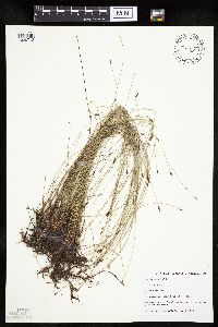 Eleocharis palustris (L.) Roemer & Schultes 499332[1020718]Capistrant, A. AMC0601998-07-22 United States, Minnesota, Carver, Carver Co, T116N R25W S16;;116N;25W;16, 44.855363 -93.838918 |
MIN:Plants |  Eleocharis elliptica Kunth 910632[1020039]Perry, Ethan 20060152006-08-18 United States, Minnesota, Itasca, Itasca County...2.8 miles NE of Scenic State Park office...T61N R25W SWSW27;George Washington State Forest;061N;25W;27, 47.7383333 -93.53 |
MIN:Plants |  Eleocharis compressa var. acutisquamata (Buckley) S.G. Smith 454446[1020007]Lee, Michael MDL28142000-07-14 United States, Minnesota, Lake, Finland State Forest. Lake County ... two miles north-northeast of Finland near the pump house for the old Air Force Base ... T57N R7W NW1/4 of SE1/4 of NW1/4 Sec. 9. 057N 07W 9, 47.436496 -91.225047 |
MIN:Plants | Eleocharis nitida Fernald 905113[1020350]Greenlee, Jack United States, Minnesota, Cook, Detailed locality information protected. This is typically done to protect rare or threatened species localities. |
MIN:Plants |  Eleocharis acicularis (Leiberg, J.B.) 585859[1019910]Porter, C.; et al. 94101963-07-19 United States, Wyoming, Teton, Teton County. Grand Teton National Park. Pond on Signal Mountain;Grand Teton National Park, 2073m |
MIN:Plants | 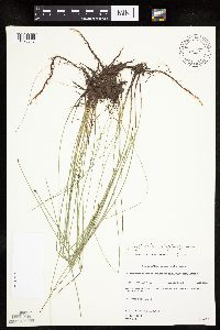 Eleocharis elliptica Kunth 488987[1020043]Gerdes, Lynden 32641998-07-24 United States, Minnesota, Lake, Superior National Forest. T61N R10W S32SWNW. Lake County...Superior National Forest. Old sand pit between Tony Lake and old segment of Tomahawk Road.. 061N 10W 32, 47.726203 -91.63027 |
MIN:Plants | Eleocharis flavescens var. olivacea (Torrey) Gleason 81843[1020267]Umbach, L. United States, Indiana, Porter, Detailed locality information protected. This is typically done to protect rare or threatened species localities. |
MIN:Plants | Eleocharis flavescens var. olivacea (Torrey) Gleason 459832[1020257]Gerdes, Lynden United States, Minnesota, Itasca, Detailed locality information protected. This is typically done to protect rare or threatened species localities. |
MIN:Plants | Eleocharis quinqueflora (Hartmann) O. Schwarz 476121[1020785]Wheeler, Gerald United States, Minnesota, Redwood, Detailed locality information protected. This is typically done to protect rare or threatened species localities. |
MIN:Plants |  Eleocharis palustris (L.) Roemer & Schultes 430998[1020745]Myhre, K. 55481995-06-13 United States, Minnesota, Aitkin, Aitkin Co.; Located 3 miles southeast of Big Sandy Lake; Camp Lake; T 49N R 23W SW1/4 of NW1/4 of Sec 13;Savanna State Forest;049N;23W;13, 46.731105 -93.202145 |
MIN:Plants |  Eleocharis obtusa (Willdenow) Schultes 589363[1020457]Abbe, E. s.n.1927-08-16 United States, North Carolina, near Smokemont ... up the road to Indian Gap along Mingus Creek, Great Smoky Mountains;Great Smoky Mountains National Park |
MIN:Plants |  Eleocharis ovata (Roth) Roemer & Schultes 910704[1020582]Rowe, Erika ERR2932007-09-13 United States, Minnesota, Hubbard, Hubbard County...0.6 miles north of Cty Hwy 33; 3.5 miles SW of Akeley; 2.8 miles south of State Hwy 34...unnamed lake...T140N R32W SWNE S08. 140N 32W 8, 46.9580556 -94.7508333 |
MIN:Plants | Eleocharis nitida Fernald 897415[1020351]Delaney, B. United States, Minnesota, Lake, Detailed locality information protected. This is typically done to protect rare or threatened species localities. |
MIN:Plants | 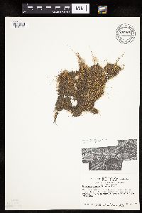 Eleocharis acicularis (Leiberg, J.B.) 680905[1019906]Swanson, Steven 4281975-06-12 United States, Wisconsin, La Crosse, Mississippi River (Navigation Pool #8) ... La Crosse Co, Site 7 ... S edge of I-90 levee;Upper Mississippi National Wildlife Refuge |
MIN:Plants |  Eleocharis obtusa (Willdenow) Schultes 505387[1102666]Budelsky, R. RAB5151998-07-16 United States, Minnesota, Washington, Washington Co, MN. T30N R21W S22;;030N;21W;22, 45.072217 -92.913898 |
MIN:Plants |  Eleocharis melanocarpa Torrey 81726[1020335]Umbach, L. s.n.1896-07-18 United States, Indiana, Porter, Dune Park;Indiana Dunes National Lakeshore;;;, 41.663093 -87.032128 |
MIN:Plants | Eleocharis nitida Fernald 491338[1020354]Perry, Ethan United States, Minnesota, Saint Louis, Detailed locality information protected. This is typically done to protect rare or threatened species localities. |
MIN:Plants |  Eleocharis acicularis (Leiberg, J.B.) 508927[1019819]Lee, Michael MDL22241998-07-02 United States, Minnesota, Stearns, Stearns County ... On west side of County Road 10 one mile north of Roscoe ... T123N R32W S1/2 of NE1/4 of SE1/4 Sec. 24;;123N;32W;24, 45.448285 -94.650389 |
MIN:Plants | Eleocharis robbinsii Oakes 480938[1020805]Scott, P. United States, Minnesota, Lake, Detailed locality information protected. This is typically done to protect rare or threatened species localities. |
MIN:Plants | 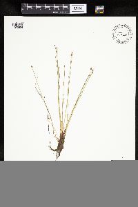 Eleocharis ovata (Roth) Roemer & Schultes 477794[1020534]Lee, Michael; et al. MDL22691998-07-21 United States, Minnesota, Stearns, Stearns County ... 1-1/2 miles east of Cold Spring ... T123N R30W SW1/4 of SW/14 [sic] of NE1/4 Sec. 24;;123N;30W;24, 45.449572 -94.394077 |
MIN:Plants | 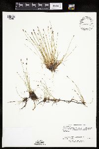 Eleocharis palustris (L.) Roemer & Schultes 508999[1020681]Lee, Michael MDL20441998-05-19 United States, Minnesota, Stearns, Stearns County ... Six miles south of St. Augusta ... T122N R28W SE1/4 of SE1/4 Sec. 12, NE1/4 of NE1/4 Sec. 13;;122N;28W;12 &13, 45.369929 -94.199706 |
MIN:Plants | Eleocharis nitida Fernald 493634[1020342]Lee, Michael United States, Minnesota, Lake, Detailed locality information protected. This is typically done to protect rare or threatened species localities. |
MIN:Plants | 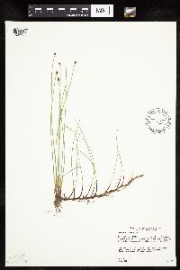 Eleocharis elliptica Kunth 493300[1020042]Gerdes, Lynden 49682004-08-12 United States, Minnesota, Lake, Superior National Forest. T61N R07W S14NESEN. Lake County...Superior National Forest. Approximately 13.17 miles NE of Isabella, MN and 0.77 mile SE of Sumpet Lake. Unnamed lake draining into Fool Hen Creek.. 061N 07W 14, 47.768865 -91.167778 |
MIN:Plants | 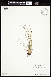 Eleocharis palustris (L.) Roemer & Schultes 454947[1020722]Biederman, L. 3561999-08-11 United States, Minnesota, Rock, Rock County ... in tire rut on Lower Mound Trail in Blue Mounds State Park ... T103N R45W 26;Blue Mounds State Park;103N;45W;26, 43.6961 -96.202618 |
MIN:Plants | Eleocharis nitida Fernald 435124[1020340]Anderson, Chel United States, Minnesota, Cook, Detailed locality information protected. This is typically done to protect rare or threatened species localities. |
MIN:Plants | 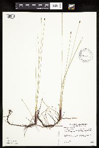 Eleocharis elliptica Kunth 488169[1020024]Gerdes, Lynden 47752003-07-18 United States, Minnesota, Lake, Superior National Forest. T58N R09W S22NENE Lake County ... Superior National Forest. Approximately 9.39 miles SW of Isabella, MN and 0.96 miles SSE of Spruce Lake; 0.27 mile S of the rail road.. 058N 09W 22, 47.49466 -91.458793 |
MIN:Plants |  Eleocharis palustris (L.) Roemer & Schultes 459964[1020725]Mensing, D. 96-951996-06-29 United States, Minnesota, Clearwater, Sucker Creek. SW1/4 of SW1/4 of section;;144N;36W;29, 47.260555 -95.265258 |
MIN:Plants | Eleocharis rostellata (Torrey) Torrey 505587[1020815]Harris, Fred United States, Minnesota, Le Sueur, Detailed locality information protected. This is typically done to protect rare or threatened species localities. |
MIN:Plants | Eleocharis nitida Fernald 897420[1020353]Delaney, B. United States, Minnesota, Lake, Detailed locality information protected. This is typically done to protect rare or threatened species localities. |
MIN:Plants |  Eleocharis acicularis (Leiberg, J.B.) 515050[1019749]Lee, Michael MDL37922004-08-13 United States, Minnesota, Todd, TODD COUNTY...6 1/2 miles southwest of Staples...(tributary to Moran Creek)...T132N R33W NE1/4 of SW1/.4 of NW1/4 Sec.6;;132N;33W;06, 46.274299 -94.886073 |
MIN:Plants |  Eleocharis erythropoda Steudel 69339[1020163]Smith, Welby 157111989-07-12 United States, Minnesota, Mille Lacs, Mille Lacs County ... On the south side of Silver Lake, about one mile east of Princeton ... SE1/4 NE1/4 section 34, T36N R26W. 036N 26W 34, 45.5680556 -93.5527778 |
MIN:Plants | 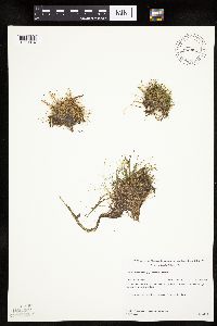 Eleocharis acicularis (Leiberg, J.B.) 490996[1019814]Gerdes, Lynden; et al. 36501999-07-27 United States, Minnesota, Cook, Boundary Waters Canoe Area Wilderness / Superior National Forest. T65N R03E S33SWNW. Cook County ... Superior National Forest, John Lake area, BWCAW. Beaver dammed drainage leaving the west end of lake.. 065N 03E 33, 48.071844 -90.06797 |
MIN:Plants |  Eleocharis palustris (L.) Roemer & Schultes 680317[1285224]Bright, R. 74-2281974-09-29 United States, Idaho, Franklin, Franklin Co. ... near old Del Rio Swimming Pool, 3 mile west of Preston., 1372m |
MIN:Plants |  Eleocharis ovata (Roth) Roemer & Schultes 438545[1020502]Whitfeld, T.J.S. 6292005-07-21 United States, Minnesota, Clearwater, Clearwater County...1/4 east [sic] of Waldee Trail; 3/4 west [sic] of Hwy 39. South end of small lake...T143N R37W SESW5;White Earth Indian Reservation;143N;37W;05, 47.230911 -95.39276 |
MIN:Plants |  Eleocharis macrostachya Britton 915027[1020315]Smith, Welby 225321993-06-22 United States, Minnesota, Stevens, Pepperton Wildlife Management Area. Stevens County...On a national waterfowl production area, about 4.5 miles south-southwest of Donnelly...T 125N R 43W SE1/4 of SW1/4 of Sec 15. 125N 43W 15, 45.636277 -96.05714 |
MIN:Plants | 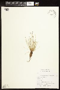 Eleocharis obtusa (Willdenow) Schultes 499321[1102665]Budelsky, R. RAB5421998-07-16 United States, Minnesota, Washington, Washington Co, T30N R21W S22;;030N;21W;22, 45.072217 -92.913898 |
MIN:Plants |  Eleocharis ovata (Roth) Roemer & Schultes 221981[1020586]Rosendahl, C. 4141b1921-08-31 United States, Wisconsin, Saint Croix, St. Croix River about 2-1/2 miles N. of Stillwater, St. Croix County;Saint Croix National Riverway;;;, 45.093688 -92.758563 |
MIN:Plants | Eleocharis rostellata (Torrey) Torrey 82029[1020826]Nelson, Aven; et al. United States, Wyoming, Park, Detailed locality information protected. This is typically done to protect rare or threatened species localities. |
MIN:Plants |  Eleocharis bella (Piper) Svenson 359546[1019911]Mason, Herbert 119301938-07-11 United States, California, Tuolumne, Miguel Meadow, west of Hetch Hetchy;Yosemite National Park, 1585m |
MIN:Plants | Eleocharis rostellata (Torrey) Torrey 283354[1020825]Moore, J.; et al. United States, Texas, Culberson, Detailed locality information protected. This is typically done to protect rare or threatened species localities. |
MIN:Plants | Eleocharis wolfii (A. Gray) A. Gray ex Britton 476224[1020831]Wheeler, Gerald United States, Minnesota, Scott, Detailed locality information protected. This is typically done to protect rare or threatened species localities. |
MIN:Plants | Eleocharis macrostachya Britton 444328[]Bright, R. 72-681972-00-00 United States, Idaho, Bannock, [no further data] |
MIN:Plants |  Eleocharis elliptica Kunth 498995[1020027]Carlson, Bruce; et al. Wypt 4742004-08-09 United States, Minnesota, Carlton, Fond du Lac State Forest. Carlton County ... 6.4 miles SE of Cromwell, 1.75 miles north of Carlton County Road 4, 0.6 miles south of Kettle Lake ... T048N R19W NWNW29 ... DNR Releve 3461. 048N 19W 29, 46.613686 -92.776128 |
MIN:Plants | 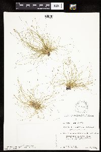 Eleocharis intermedia Schultes 616846[1020272]Moore, John; Moore, Marjorie 4371969-08-26 United States, Minnesota, Crow Wing, Crow Wing Natural History Area. Crow Wing County ... south east of Chandler Lake, S.W. 1/4, Sect. 22, Garrison Twp.;Crow Wing Natural Area;044N;28W;22, 46.27899 -93.863336 |
MIN:Plants | 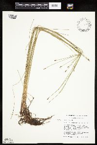 Eleocharis palustris (L.) Roemer & Schultes 471884[1020685]Mensing, D. 96-1461996-07-02 United States, Minnesota, Isanti, Anoka Co. T34N R23W SW1/4 of the SE1/4 of S21 [this is in Isanti Co. not Anoka]; floodplain of Cedar Creek;Cedar Creek National History Area;034N;23W;21, 45.421163 -93.214653 |
MIN:Plants | Eleocharis quinqueflora (Hartmann) O. Schwarz 499034[1020788]Lee, Michael United States, Minnesota, Lake, Detailed locality information protected. This is typically done to protect rare or threatened species localities. |
MIN:Plants | 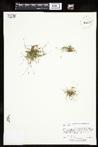 Eleocharis intermedia Schultes 909817[1020276]Lee, Michael MDL45692007-09-26 United States, Minnesota, Itasca, Itasca County ... Along the Mississippi River at Veterans Memorial Park in the city of Grand Rapids ... ~3/4 mile downstream from the dam ... T55N R25W NE1/4 of SE1/4 Sec. 21 ... UTM: 5230844N 460933E. 055N 25W 21, 47.231866 -93.522768 |
MIN:Plants | Eleocharis robbinsii Oakes 479581[1020804]Homoya, M.; Scott, P. United States, Minnesota, Saint Louis, Detailed locality information protected. This is typically done to protect rare or threatened species localities. |
MIN:Plants | 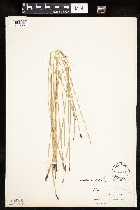 Eleocharis macrostachya Britton 81903[1020328]Rydberg, P.; Bessey, E. 38091897-08-12 United States, Wyoming, Park, Yellowstone Lake, Yellowstone Park;Yellowstone National Park, 2286m |
MIN:Plants | Eleocharis NULL 468254[]Shimek, B. s.n.1894-05-10 United States, Iowa, Johnson, Johnson Co. ... Newport Twp. |
MIN:Plants | 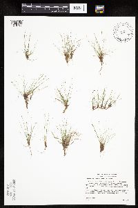 Eleocharis acicularis (Leiberg, J.B.) 438853[1019785]Gerdes, Lynden 50592005-08-04 United States, Minnesota, Saint Louis, Superior National Forest. T60N R12W S15NESWNE St. Louis County ... Superior National Forest. SE of Babbit ... Approximately 0.06 mile south down FR 112 from its junction with FR 424. East side of FR 112. 060N 12W 15, 47.679999 -91.84956 |
MIN:Plants | 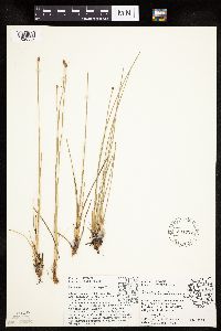 Eleocharis melanocarpa Torrey 531727[1020332]Umbach, L. 10811906-06-23 United States, Indiana, Porter, Northern Porter County ... Dune Park on Lake Michigan (7 mi. E. of Gary, Ind, SE of Chicago);Indiana Dunes National Lakeshore;;;, 41.663093 -87.032128 |
MIN:Plants | 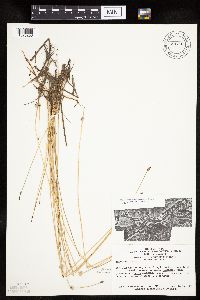 Eleocharis erythropoda Steudel 681291[1020253]Swanson, Steven 7191975-06-20 United States, Wisconsin, La Crosse, Mississippi River (Navigation Pool #8) ... La Crosse Co, Site 15, spit on the inside bend of a side channel;Upper Mississippi National Wildlife Refuge |
MIN:Plants | 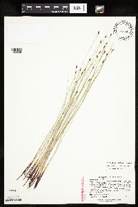 Eleocharis compressa var. acutisquamata (Buckley) S.G. Smith 477082[1020005]Lee, Michael MDL21321998-06-10 United States, Minnesota, Stearns, Stearns County ... Along Co. Rd. 137 in Waite Park ... T124N R28W NW1/4 of NW1/4 Sec. 30;;124N;28W;30, 45.522862 -94.250075 |
MIN:Plants | Eleocharis nitida Fernald 912170[1020349]Greenlee, Jack United States, Minnesota, Lake, Detailed locality information protected. This is typically done to protect rare or threatened species localities. |
MIN:Plants |  Eleocharis erythropoda Steudel 489595[1020114]Lee, Michael MDL26801999-08-05 United States, Minnesota, Lake, North Shore / Split Rock Lighthouse State Park. Lake County...Along the Lake Superior shore in Split Rock Lighthouse State Park, 7 1/2 miles southwest of Beaver Bay...1/4 mile east of the mouth of the Split Rock River...T54N R8W SW1/4 of NE1/4 of NW1/4 Sec. 7section). 054N 08W 7, 47.181842 -91.407951 |
MIN:Plants |  Eleocharis mamillata subsp. mamillata (H. Lindberg) H. Lindberg 482132[1020661]Gerdes, Lynden 27121998-06-15 United States, Minnesota, Cook, South Lake Hiking Trail, sedge meadow/open-drainage area southeast of East Otter Lake. NESW of section;Superior National Forest;065N;01W;31, 48.070172 -90.501305 |
MIN:Plants |  Eleocharis palustris (L.) Roemer & Schultes 476723[1020723]Lee, Michael MDL20981998-06-04 United States, Minnesota, Stearns, Stearns County ... 1 1/4 miles west of Clearwater. abundant along the shore of Fuller Lake ... T123N R27W SE1/4 of SW1/4 of NW1/4 Sec. 34. 123N 27W 34, 45.413724 -94.057956 |
MIN:Plants |  Eleocharis bolanderi A. Gray 233627[1019912]Congdon, J. s.n.1898-08-03 United States, California, Mariposa, Bridal Veil Trail, Mariposa County;Yosemite National Park |
MIN:Plants | 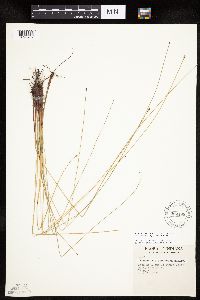 Eleocharis palustris (L.) Roemer & Schultes 599198[1020769]Tryon, R. 10001935-06-21 United States, Indiana, Porter, Road at E end of Dunes State Park, Porter Co.;Indiana Dunes National Lakeshore;;;, 41.663093 -87.032128 |
MIN:Plants |  Eleocharis palustris (L.) Roemer & Schultes 907096[1020701]Smith, Welby; et al. 310672008-08-05 United States, Minnesota, Saint Louis, Boundary Waters Canoe Area Wilderness / Superior National Forest. St. Louis County...Along the shore of Clark Lake in the Boundary Waters Canoe Area Wilderness, Superior National Forest...T 63N R 14W NE1/4 of SW1/4 of Sec 23. 063N 14W 23, 47.9213889 -92.0877778 |
MIN:Plants | Eleocharis rostellata (Torrey) Torrey 479220[1020809]Harris, Fred United States, Minnesota, Le Sueur, Detailed locality information protected. This is typically done to protect rare or threatened species localities. |
MIN:Plants |  Eleocharis ovata (Roth) Roemer & Schultes 454473[1020577]Lee, Michael MDL25321999-06-25 United States, Minnesota, Lake, Crosby Manitou State Park / North Shore. Lake County ... George H. Crosby-Manitou State Park six miles north of Little Marais ... fault line east of Manitou River ... T58N R6W SE1/4 of SE1/4 Sec. 21. 058N 06W 21, 47.493631 -91.097586 |
MIN:Plants | Eleocharis nitida Fernald 463544[1020363]Lee, Michael United States, Minnesota, Lake, Detailed locality information protected. This is typically done to protect rare or threatened species localities. |
MIN:Plants |  Eleocharis acicularis (Leiberg, J.B.) 479091[1019872]Wheeler, Gerald 168221997-07-24 United States, Minnesota, Benton, Benton Co.; Ca. 0.7 mi. SSW of Watab on Rte. 55; W1/2 NW1/4 SE1/4 Sec. 27 T37n R31W (Watab 27);;037N;31W;27, 45.668416 -94.184846 |
MIN:Plants | 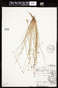 Eleocharis obtusa (Willdenow) Schultes 571597[1020454]Hartley, Thomas 13261956-07-19 United States, Wisconsin, La Crosse, Driftless Area...La Crosse County ... Lake Onalaska. (T. 16 N.; R. 7; Sect. 6);Upper Mississippi National Wildlife Refuge;016N;07W;06 |
MIN:Plants | Eleocharis nitida Fernald 488996[1020364]Gerdes, Lynden United States, Minnesota, Lake, Detailed locality information protected. This is typically done to protect rare or threatened species localities. |
MIN:Plants |  Eleocharis ovata (Roth) Roemer & Schultes 904773[1020263]Gerdes, Lynden 53282006-09-12 United States, Minnesota, Itasca, Bowstring State Forest. SE shores of Hale Lake. Approximately 7.05 miles SSW of Squaw Lake [town];Chippewa National Forest / Leech Lake Indian Reservation;147N;28W;24, 47.531191 -94.171262 |
MIN:Plants | Eleocharis quinqueflora (Hartmann) O. Schwarz 905571[1020777]Myhre, K. United States, Minnesota, Hubbard, Detailed locality information protected. This is typically done to protect rare or threatened species localities. |
MIN:Plants | Eleocharis rostellata (Torrey) Torrey 461350[1020822]Harris, Fred United States, Minnesota, Le Sueur, Detailed locality information protected. This is typically done to protect rare or threatened species localities. |
MIN:Plants |  Eleocharis intermedia Schultes 453769[1020285]Husveth, J. 95-3041995-08-21 United States, Minnesota, Ramsey, Ramsey Co, T30N R23W NW1/4 of the NW1/4 of S2;;030N;23W;2, 45.116108 -93.137483 |
Google Map
Google Maps is a web mapping service provided by Google that features a map that users can pan (by dragging the mouse) and zoom (by using the mouse wheel). Collection points are displayed as colored markers that when clicked on, displays the full information for that collection. When multiple species are queried (separated by semi-colons), different colored markers denote each individual species.