University of Minnesota
http://www.umn.edu/
612-625-5000
http://www.umn.edu/
612-625-5000
Minnesota Biodiversity Atlas
Bell Museum
Dataset: MIN-Plants
Taxa: Sapindaceae
Search Criteria: excluding cultivated/captive occurrences
Bell Museum plants | |
 MIN:Plants | 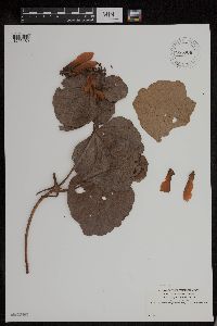 955906[1295459]Rusby, H. H. 1631896-00-00 Venezuela, Lower Orinoco [River] |
MIN:Plants | 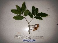 951502[1299328]Weiblen, G.D. YP4C02662012-04-12 Papua New Guinea, Morobe, Yawan Village, -6.163017 146.842983, 1732m |
MIN:Plants | 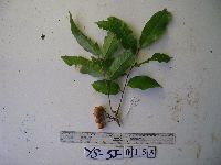 951503[1299327]Weiblen, G.D. YS3J01532012-11-23 Papua New Guinea, Morobe, Yawan Village, -6.164683 146.841717, 1855m |
MIN:Plants | 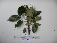 951522[1299309]Weiblen, G.D. YS2F01802010-07-23 Papua New Guinea, Morobe, Yawan Village, -6.16255 146.839933, 1721m |
MIN:Plants |  951650[1299237]Weiblen, G.D. YP1C00312011-02-09 Papua New Guinea, Morobe, Yawan Village, -6.163017 146.842983, 1732m |
MIN:Plants |  965923[1356682] 1947-11-22 United States, Texas |
MIN:Plants |  Cupaniopsis Radlk. 916749[]Weiblen, G. D. & Binatang Research Center WP4D08892007-03-23 Papua New Guinea, Madang, Wanang Village, -5.2373 145.177183, 115m |
MIN:Plants | Cupaniopsis Radlk. 896727[]Weiblen, G.D. TP1301996-07-31 Papua New Guinea, Simbu, O-Pio 1 ha plot, block 6, Crater Mountain Wildlife Management Area, -6.788611 145.036667, 550m |
MIN:Plants | Cupaniopsis Radlk. 897276[]Weiblen, G.D. TP4201996-07-31 Papua New Guinea, Simbu, O-Pio 1 ha plot, block 17, Crater Mountain Wildlife Management Area, -6.788611 145.036667, 550m |
MIN:Plants |  Acer saccharum var. saccharum Marshall 896982[1093913]Haferman, J. 1961996-05-18 United States, Minnesota, Scott, Approx. 0.1 miles NNE of intersection of State Highway 13 and County Road 44 on N side of highway. SW1/4 of SW1/4 of section.;;115N;22W;36, 44.72459 -93.40903 |
MIN:Plants |  Acer saccharum var. saccharum Marshall 438434[1093912]Smith, Welby 273581998-07-10 United States, Minnesota, Hubbard, Hubbard County...About 9 miles N-NW of Akeley...T 142N R 32W NW1/4 of NW1/4 of Sec 17;Paul Bunyan State Forest;142N;32W;17, 47.0125 -94.7416667 |
MIN:Plants |  Acer saccharum var. saccharum Marshall 910059[1093898]Smith, Welby 246741994-07-13 United States, Minnesota, Polk, Polk County ... About 5 miles southwest of Erskine ... T148N R43W NE1/4 of NW1/4 of Sec 25;;148N;43W;25, 47.6094444 -96.0797222 |
MIN:Plants |  Acer saccharum var. saccharum Marshall 462265[1093952]Smith, Welby 290412000-08-23 United States, Minnesota, Rice, Rice County ... At the I35 north-bound rest stop, about 4 miles west of Dundas ... T111N R21W SE1/4 of SW1/4 of Sec 12;;111N;21W;12, 44.4308333 -93.2938889 |
MIN:Plants |  Acer saccharum var. saccharum Marshall 454654[1093866]Juhnke, C. 180 CMJ FRO1999-05-05 United States, Minnesota, Goodhue, Frontenac State Park Goodhue County ... Bluff edge woods behind picnic shelter ... T112N R13W NW SW NW 2;Frontenac State Park;112N;13W;02, 44.53507 -92.33916 |
MIN:Plants |  Acer saccharum var. saccharum Marshall 489307[1093911]Smith, Welby 276861999-05-08 United States, Minnesota, Carlton, Carlton County ... Jay Cook State Park ... ca 500 m downstream from Oldenberg Pt ... T48N R16W SE1/4 of SE1/4 of Sec 10;Jay Cooke State Park;048N;16W;10, 46.6491667 -92.3491667 |
MIN:Plants | 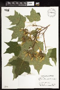 Acer saccharum var. saccharum Marshall 905269[1093966]Smith, Welby 294192003-07-17 United States, Minnesota, Martin, Martin County...Timberlane County Park, on the north side of Iowa Lake...T101N R30W SW1/4 of NW1/4 of Sec 32;Timberlane County Park;101N;30W;32, 43.5116667 -94.4633333 |
MIN:Plants | 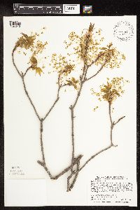 Acer saccharum var. saccharum Marshall 489021[1093942]Smith, Welby 276301999-04-30 United States, Minnesota, Washington, Afton State Park. Washington County ... Afton State Park; about 7 miles NE of Hastings ... bluff overlooking the St. Croix River ... T27N R20W NE1/4 of NW1/4 of Sec 11. 027N 20W 11, 44.8466682 -92.7705536 |
MIN:Plants | 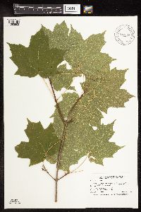 Acer saccharum var. saccharum Marshall 912458[1093863]Smith, Welby 254271994-09-07 United States, Minnesota, Cass, Cass County...On the west side of Beauty Lake...T 134N R 30W SW1/4 of SE1/4 of Sec 21;Pillsbury State Forest;134N;30W;21, 46.4008333 -94.4605556 |
MIN:Plants | 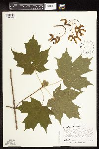 Acer saccharum var. saccharum Marshall 488218[1093853]Lee, Michael MDL27502000-06-22 United States, Minnesota, Lake, Superior National Forest. Lake County...east of Ninemile Creek and County Road 7 in the Superior National Forest 2-1/2 miles north-northeast of Cramer...ridge north of Paccini Lake...T59N R6W SW1/4 of SE1/4 Sec. 27. 059N 06W 27, 47.56589 -91.07577 |
MIN:Plants |  Acer saccharum var. saccharum Marshall 899541[1093967]Smith, Welby 292442001-08-01 United States, Minnesota, Washington, William O'Brien State Park. Washington County...William O'Brien State Park, about 1.5 miles north of Marine on St. Croix...T32N R19W NW1/4 of NE1/4 of Sec 31. 032N 19W 31, 45.2233333 -92.7613889 |
MIN:Plants |  Acer saccharum var. saccharum Marshall 499450[1093983]McNaughton, Lynn 1722003-10-14 United States, Minnesota, Waseca, Maplewood Park: Waseca County ... NE1/4 of SW1/4 of Sect.9, T107N, R22W.;Maplewood County Park;107N;22W;09, 44.08766 -93.47676 |
MIN:Plants |  Acer saccharum var. saccharum Marshall 920132[1093879]Smith, Welby 221781993-05-20 United States, Minnesota, Otter Tail, Otter Tail County...Maplewood State Park about 7 miles southeast of Pelican Rapids...T135N R42W NW1/4 of NW1/4 of Sec 11;Maplewood State Park;135N;42W;11, 46.5269444 -95.945 |
MIN:Plants |  Acer saccharum var. saccharum Marshall 488766[1093930]Smith, Welby 265711997-06-04 United States, Minnesota, Renville, Beaver Falls County Park. Renville County ... Beaver Falls County Park, about 4 miles northeast of Redwood Falls ...T113 N R 35W SW1/4 of NW1/4 of Sec 22. 113N 35W 22, 44.582222 -95.0533371 |
MIN:Plants |  Acer saccharum var. saccharum Marshall 498905[1093996]McNaughton, Lynn 1582003-09-23 United States, Minnesota, Waseca, Maplewood Park: Waseca County ... NE1/4 of SW1/4 of Sect. 9, T107N, R22W.;Maplewood County Park;107N;22W;09, 44.08766 -93.47676 |
MIN:Plants |  Acer saccharum var. saccharum Marshall 508078[1093881]Smith, Welby 166931990-05-29 United States, Minnesota, Dodge, Dodge County ... About 3 miles northwest of Byron ... overlooking the South Branch Middle Fork Zumbro River ... T 107N R 16W NE1/4 of SW1/4 of Sec 13. 107N 16W 13, 44.0708351 -92.6858368 |
MIN:Plants |  Acer saccharum var. saccharum Marshall 920173[1093877]Smith, Welby 222001993-05-25 United States, Minnesota, Meeker, Meeker County...On the south side of T.H. 12, about 2 miles southeast of Darwin...T119N R30W NW1/4 of SE1/4 of Sec 25;;119N;30W;25, 45.0872222 -94.3916667 |
MIN:Plants |  Acer saccharum var. saccharum Marshall 428916[1093854]Smith, Welby 287572000-07-18 United States, Minnesota, Ramsey, Ramsey County ... Battle Creek County Park, in St. Paul ... T 28N R 22W SE1/4 of SE1/4 of Sec 3;Battle Creek County Park;028N;22W;03, 44.9361115 -93.0280533 |
MIN:Plants |  Acer saccharum var. saccharum Marshall 461779[1093856]Little Jr., Elbert 427711991-07-22 United States, Minnesota, Cook, Cook Co.; Near Hovland fire tower, 5 mi N of Hovland;Grand Portage State Forest / North Shore;062N;03E;, 47.84984 -90.06495 |
MIN:Plants |  Acer saccharum var. saccharum Marshall 912472[1094018]Smith, Welby 228421993-07-14 United States, Minnesota, Sibley, Vale Wildlife Management Area. Sibley County...Vale State Wildlife Management Area, ca 2.5 miles N-NW of Henderson; in the valley of High Island Creek, ca 2.5 miles SW of its confluence with the Minn R...T 113N R 26W NE1/4 of SW1/4 of Sec 27. 113N 26W 27, 44.5625 -93.9427778 |
MIN:Plants |  Acer saccharum var. saccharum Marshall 916527[1093978]Smith, Welby 223031993-06-03 United States, Minnesota, Sibley, Vale Wildlife Management Area. Sibley County ... Vale State Wildlife Management Area; in the valley of High Island Creek, about 2.5 miles southwest its confluence with the Minnesota River ... T113N R26W NE1/4 of SW1/4 of Sec 27. 113N 26W 27, 44.5625 -93.9427778 |
MIN:Plants |  Acer saccharum var. saccharum Marshall 915752[1094019]Smith, Welby 251781994-08-18 United States, Minnesota, Beltrami, Lake Bemidji State Park. Beltrami County...On the northeast side of Lake Bemidji, in Lake Bemidji State Park...T147 N R 33W SW1/4 of NE1/4 of Sec 23. 147N 33W 23, 47.5347222 -94.8311111 |
MIN:Plants |  Acer saccharum var. saccharum Marshall 484257[1093984]Juhnke, C. 346 CMJ FRO1999-06-10 United States, Minnesota, Goodhue, Frontenac State Park Goodhue County ... NW facing slope from self-guided trail to Mississippi River...T112N R13W SWSENE2;Frontenac State Park;112N;13W;02, 44.53507 -92.33916 |
MIN:Plants |  Acer saccharum var. saccharum Marshall 788865[1093860]Smith, Welby 103141985-05-30 United States, Minnesota, Le Sueur, About 2 miles west of Montgomery. NW1/4 SE1/4 of section;Richter Woods County Park;111N;23W;08, 44.4333333 -93.6138889 |
MIN:Plants |  Acer saccharum var. saccharum Marshall 834868[1093859]Juhnke, C. 328CMJ1993-06-05 United States, Minnesota, Fillmore, Picnic ground at Mystery Cave I entrance. SE1/4 SE1/4 SE1/4 of section;Forestville State Park;102N;12W;19, 43.6236884 -92.3189836 |
MIN:Plants |  Acer saccharum var. saccharum Marshall 151003[1093993]Sheldon, Edmund s.n.1895-04-00 United States, Minnesota, Hennepin, Hennepin Co.;;;;, 45.01667 -93.45 |
MIN:Plants |  Acer saccharum var. saccharum Marshall 151010[1093862]Sandberg, John s.n.1890-05-00 United States, Minnesota, Hennepin, [no further data];;;;, 45 -93.47 |
MIN:Plants |  Acer saccharum var. saccharum Marshall 151011[1093974]Sandberg, John s.n.1886-05-00 United States, Minnesota, Goodhue, Vasa;Dorer Memorial Hardwood State Forest;112N;16W;15, 44.50708 -92.722 |
MIN:Plants |  Acer saccharum var. saccharum Marshall 151013[1093991]Ramaley, F. s.n.1894-05-00 United States, Minnesota, Ramsey, Ramsey Co.;;;;, 45.03333 -93.08333 |
MIN:Plants | 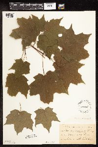 Acer saccharum var. saccharum Marshall 151014[1094009]Taylor, B. T15941891-06-00 United States, Minnesota, Waseca, Janesville;;N;;, 44.116078 -93.708004 |
MIN:Plants | 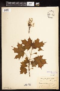 Acer saccharum var. saccharum Marshall 151129[1093995]Moore, W. s.n.1900-05-18 United States, Minnesota, Ramsey, Groveland Park [St. Paul neighborhood between Highland and Summit aves.];;028N;23W;00, 44.90516 -93.16646 |
MIN:Plants | 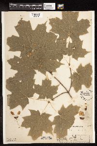 Acer saccharum var. saccharum Marshall 151142[1093870]Moyer, Lycurgus s.n.1894-08-28 United States, Minnesota, Pope, Lake Minnewaska;;125N;38W;, 45.62876 -95.44875 |
MIN:Plants | 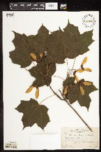 Acer saccharum var. saccharum Marshall 151143[1093716]Butters, F.; et al. 39551920-06-29 United States, Minnesota, Houston, About 1 1/2 mi NW of Spring Grove;;101N;07W;, 43.54392 -91.6707 |
MIN:Plants | 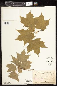 Acer saccharum var. saccharum Marshall 151146[1094003]Sheldon, Edmund s.n.1895-05-00 United States, Minnesota, Hennepin, Minneapolis;;;;, 44.98 -93.26361 |
MIN:Plants |  Acer saccharum var. saccharum Marshall 151148[1094011]Sheldon, Edmund S25421892-06-00 United States, Minnesota, Mille Lacs, Mille Lacs Reservation;Mille Lacs Indian Reservation;;;, 46.0967 -93.5039 |
MIN:Plants |  Acer saccharum var. saccharum Marshall 151149[1093869]Sheldon, Edmund s.n.1895-05-00 United States, Minnesota, Hennepin, Minneapolis;;;;, 44.98 -93.26361 |
MIN:Plants |  Acer saccharum var. saccharum Marshall 151150[1093873]Aiton, G. s.n.1890-08-00 United States, Minnesota, Hennepin, Excelsior;;N;;, 44.903296 -93.566346 |
MIN:Plants |  Acer saccharum var. saccharum Marshall 151151[1093975]Frost, W. F4921894-04-00 United States, Minnesota, Hennepin, Minnehaha Falls;Minnehaha Falls Park;028N;23W;17, 44.9118 -93.20343 |
MIN:Plants | 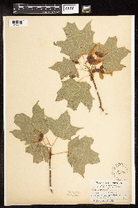 Acer saccharum var. saccharum Marshall 151153[1093880]Aiton, G. s.n.1890-08-00 United States, Minnesota, Hennepin, Minneapolis;;;;, 44.98 -93.26361 |
MIN:Plants | 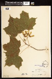 Acer saccharum var. saccharum Marshall 151155[1093868]Rosendahl, C. 4511902-06-10 United States, Minnesota, Houston, Spring Grove;;101N;07W;, 43.54392 -91.6707 |
MIN:Plants | 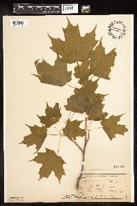 Acer saccharum var. saccharum Marshall 151156[1093947]Sheldon, Edmund S21941892-06-00 United States, Minnesota, Mille Lacs, Mille Lacs Lake;;N;;, 46.23333 -93.65 |
MIN:Plants | 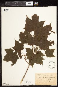 Acer saccharum var. saccharum Marshall 151157[1094007]Ballard, C. B1201891-06-00 United States, Minnesota, Carver, Chaska;;;;, 44.78944 -93.60194 |
MIN:Plants |  Acer saccharum var. saccharum Marshall 151158[1093959]Arthur, J.; et al. B2251886-07-22 United States, Minnesota, Saint Louis, Vermilion Lake;;;;, 47.89167 -92.36667 |
MIN:Plants |  Acer saccharum var. saccharum Marshall 151159[1093962]Aiton, G. s.n.1890-07-00 United States, Minnesota, Hennepin, [no further data];;;;, 45 -93.47 |
MIN:Plants |  Acer saccharum var. saccharum Marshall 151160[1093722]Manning, Sara; Moyer, Lycurgus s.n.1898-06-30 United States, Minnesota, Wabasha, Lake City;;111N;12W;04, 44.44702 -92.25898 |
MIN:Plants |  Acer saccharum var. saccharum Marshall 151161[1093986]Sheldon, Edmund s.n.1895-04-00 United States, Minnesota, Hennepin, Hennepin Co.;;;;, 45.01667 -93.45 |
MIN:Plants |  Acer saccharum var. saccharum Marshall 151162[1093885]Butters, F.; et al. 36511918-07-22 United States, Minnesota, Wabasha, Wabasha Co.;;;;, 44.28333 -92.21667 |
MIN:Plants |  Acer saccharum var. saccharum Marshall 151163[1093953]Burglehaus, F. s.n.1892-06-01 United States, Minnesota, Hennepin, Near Minneapolis;;029N;24W;, 44.99193 -93.28815 |
MIN:Plants |  Acer saccharum var. saccharum Marshall 158068[1093919]Sheldon, Edmund S2971891-06-00 United States, Minnesota, Blue Earth, Madison Lake;;108N;25W;, 44.15249 -93.82835 |
MIN:Plants |  Acer saccharum var. saccharum Marshall 224482[1093970]Butters, F.; et al. s.n.1924-07-05 United States, Minnesota, Cook, NE Cook Co.;;;;, 48.01198 -89.87915 |
MIN:Plants |  Acer saccharum var. saccharum Marshall 282073[1093990]Rosendahl, C. 24311910-04-13 United States, Minnesota, Hennepin, Ft. Snelling Reservation, Minneapolis [old regional park spanning junction of Minnesota and Mississippi rivers].;;028N;23W;, 44.90516 -93.16646 |
MIN:Plants |  Acer saccharum var. saccharum Marshall 282429[1093956]Buell, Murray 3171932-07-04 United States, Minnesota, Clearwater, Itasca Park. 1/2 mi. S of nursery on Jefferson Hwy. SE1/4 NW1/4 Sec. 12, T143N, R36W.;Itasca State Park;143N;36W;12, 47.21774 -95.18017 |
MIN:Plants |  Acer saccharum var. saccharum Marshall 284567[1093997]Cooper, William s.n.1930-08-00 United States, Minnesota, Pine, Sturgeon Lake [Pine Co. pencilled in later];;;;, 46.38111 -92.755 |
MIN:Plants |  Acer saccharum var. saccharum Marshall 284620[1093893]Rosendahl, C. 4681902-06-11 United States, Minnesota, Houston, Spring Grove;;101N;07W;, 43.54392 -91.6707 |
MIN:Plants |  Acer saccharum var. saccharum Marshall 288221[1093954]Anonymous s.n.1914-06-09 United States, Minnesota, Wright, Clearwater;;;;, 45.41944 -94.04861 |
MIN:Plants | 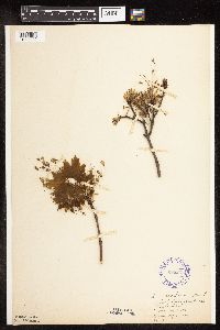 Acer saccharum var. saccharum Marshall 288233[1093988]Anonymous 81914-05-07 United States, Minnesota, Hennepin, East River Bank, near Lake Street., 45 -93.47 |
MIN:Plants | 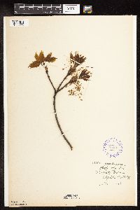 Acer saccharum var. saccharum Marshall 288295[1093992]Meck, Carlton s.n.1914-04-18 United States, Minnesota, Ramsey, University Farm. Ramsey Co.;;029N;23W;, 44.99208 -93.16639 |
MIN:Plants | 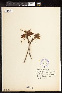 Acer saccharum var. saccharum Marshall 288363[1093987]Piruerisal, F. s.n.1914-04-07 United States, Minnesota, Ramsey, St. Anthony Park [St Paul neighborhood near U of M];;029N;23W;, 44.99208 -93.16639 |
MIN:Plants | 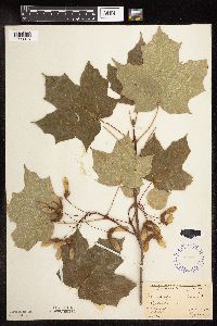 Acer saccharum var. saccharum Marshall 289397[1093875]Fassett, N.; Hotchkiss, N. 34461926-08-25 United States, Minnesota, Wabasha, Wabasha Co.; Minneiska;;;;, 44.195 -91.8719 |
MIN:Plants | 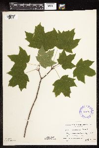 Acer saccharum var. saccharum Marshall 300284[1093933]Linnaean Club, U of M, 2611943-07-10 United States, Minnesota, Rice, Nerstrand Woods. Along wagon road running S from main road.;Nerstrand Woods State Park;110N;19W;, 44.32706 -93.10089 |
MIN:Plants | 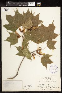 Acer saccharum var. saccharum Marshall 332601[1093876]Grant, Martin 67241935-09-02 United States, Minnesota, Clearwater, Itasca Park. S of campus. NW1/4 NW1/4 Sec. 12, T143N, R36W.;Itasca State Park;143N;36W;12, 47.21774 -95.18017 |
MIN:Plants | 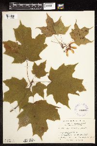 Acer saccharum var. saccharum Marshall 332626[1093955]Grant, Martin 66771935-08-22 United States, Minnesota, Clearwater, Itasca Park. "Fallen Log" trail. SW1/4 NE1/4 Sec. 10, T143N, R36W.;Itasca State Park;143N;36W;10, 47.21727 -95.22304 |
MIN:Plants | 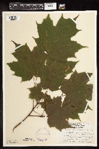 Acer saccharum var. saccharum Marshall 335571[1093969]Lakela, Olga 18721936-09-19 United States, Minnesota, Saint Louis, Bayside of the pine ridge, Sec. 19, Duluth [other collections indicates this is in T49N R13W, Minnesota Point];Minnesota Point;049N;13W;19, 46.72833 -92.04778 |
MIN:Plants | 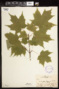 Acer saccharum var. saccharum Marshall 352790[1093944]Benner, F.; Benner, J. 6941929-08-22 United States, Minnesota, Cook, Ca. 1/2 mi. W of Hwy. 1 and 1 mi. N of Mineral Center and old Indiand sap boiling camp. Cook Co.;Grand Portage Indian Reservation / North Shore;063N;05E;, 47.93519 -89.80602 |
MIN:Plants | 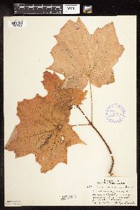 Acer saccharum var. saccharum Marshall 356650[1094002]Lakela, Olga 33911939-10-16 United States, Minnesota, Saint Louis, N-facing slope of Bardon's Peak, near Fond du Lac road, Duluth.;;048N;15W;, 46.65701 -92.25726 |
MIN:Plants | 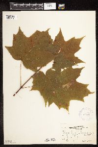 Acer saccharum var. saccharum Marshall 367204[1093721]Moore, John; Butters, F. 135061940-09-04 United States, Minnesota, Aitkin, Along Hwy. 210, 2 mi. E of Tamarack;;048N;22W;, 46.63658 -93.12692 |
MIN:Plants | 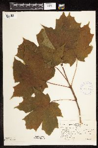 Acer saccharum var. saccharum Marshall 367301[1093720]Moore, John; Butters, F. 134381940-09-03 United States, Minnesota, Carlton, 8 mi. E of Barnum;;;;, 46.50294 -92.52007 |
MIN:Plants |  Acer saccharum var. saccharum Marshall 370107[1093918]Moore, John; et al. 141491941-05-25 United States, Minnesota, Pine, Beside Hwy. 23; 1 mi S of Nickerson, PiIne Co.;;045N;17W;, 46.37449 -92.4891 |
MIN:Plants |  Acer saccharum var. saccharum Marshall 372983[1093867]Moore, John; et al. 146101941-07-05 United States, Minnesota, Wright, 1 mi. NW of Annandale, Wright Co.;;121N;28W;, 45.28286 -94.19955 |
MIN:Plants |  Acer saccharum var. saccharum Marshall 373576[1093994]Lakela, Olga 48981942-05-08 United States, Minnesota, Saint Louis, On the grounds of Duluth Gun Club. Hwy. 4, Duluth.;;;;, 46.78333 -92.10639 |
MIN:Plants |  Acer saccharum var. saccharum Marshall 374073[1094014]Linnaean Club, U of M, 901939-05-21 United States, Minnesota, Rice, Nerstrand Woods. Near falls.;Nerstrand Woods State Park;110N;19W;, 44.32706 -93.10089 |
MIN:Plants |  Acer saccharum var. saccharum Marshall 375347[1093895]Lakela, Olga 49361942-06-07 United States, Minnesota, Carlton, Near Holyoke;;N;;, 46.4675 -92.38833 |
MIN:Plants |  Acer saccharum var. saccharum Marshall 381348[1093903]Moore, John; et al. 154851942-06-20 United States, Minnesota, Rice, Nerstrand Woods, 3 mi W of Nerstrand. Rice Co.;Nerstrand Woods State Park;110N;19W;09, 44.34887 -93.11108 |
MIN:Plants |  Acer saccharum var. saccharum Marshall 393878[1094013]Butters, F.; Abbe, E. 1901936-06-30 United States, Minnesota, Cook, Ca. 2 mi. NW of Mineral Center;Grand Portage Indian Reservation / North Shore;063N;05E;, 47.93519 -89.80602 |
MIN:Plants |  Acer saccharum var. saccharum Marshall 420786[1093934]Lakela, Olga 101511950-06-03 United States, Minnesota, Saint Louis, St. Louis Co.; Pioneer Road, E of Sucker River.;;051N;12W;, 46.9205299 -91.8805825 |
MIN:Plants | 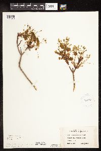 Acer saccharum var. saccharum Marshall 420950[1093973]Lakela, Olga 101321950-06-02 United States, Minnesota, Saint Louis, Forest Hill Cemetery woods, Duluth;;;;, 46.84472 -92.07111 |
MIN:Plants | 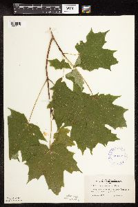 Acer saccharum var. saccharum Marshall 421070[1093940]Lakela, Olga 113151950-08-12 United States, Minnesota, Saint Louis, St. Louis Co.; Lieuna Lake, Pequaywan Lake Road, E St. Louis Co.;Cloquet Valley State Forest;053N;13W;, 47.06851 -91.98461 |
MIN:Plants | 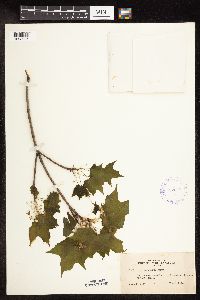 Acer saccharum var. saccharum Marshall 422648[1093985]Lakela, Olga 74611948-06-02 United States, Minnesota, Saint Louis, Arlington Ave, Duluth;;;;, 46.78333 -92.10639 |
MIN:Plants | 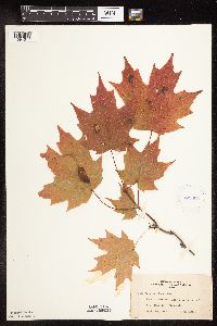 Acer saccharum var. saccharum Marshall 422690[1094017]Lakela, Olga 78841948-09-26 United States, Minnesota, Saint Louis, Bank of Prairie Lake.;;050N;20W;, 46.80928 -92.87068 |
MIN:Plants |  Acer saccharum var. saccharum Marshall 424130[1093936]Emanuel, J. 1481946-09-04 United States, Minnesota, Itasca, Nashwauk Township (Stevenson Road) ;;057N;22W;, 47.41438 -93.13223 |
MIN:Plants |  Acer saccharum var. saccharum Marshall 437038[1093894]Moore, John; Barnum, B. 161901944-05-22 United States, Minnesota, Washington, Washington Co.; 3 miles north west of Stillwater.;;030N;20W;, 45.08498 -92.81735 |
MIN:Plants |  Acer saccharum var. saccharum Marshall 441690[1093972]Lee, Michael MDL1001993-05-11 United States, Minnesota, Dakota, Dakota Co.; Hastings SNA; T 115N R 17W NW1/4 of NW1/4 of Sec 35;Hastings Scientific Natural Area;115N;17W;35, 44.72395 -92.82263 |
MIN:Plants |  Acer saccharum var. saccharum Marshall 445058[1093928]Moore, John; Huff, N. 195601947-06-13 United States, Minnesota, Itasca, 3 mi S of Swan Lake;;;;, 47.26129 -93.17944 |
MIN:Plants | 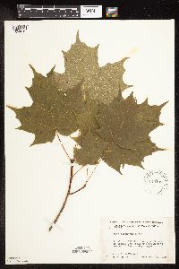 Acer saccharum var. saccharum Marshall 445198[1094010]Moore, John; Huff, N. 191181946-08-29 United States, Minnesota, Itasca, N arm of Spring Lake near the SW corner of Scenic State Park;Scenic State Park;;;, 47.71583 -93.56278 |
MIN:Plants | 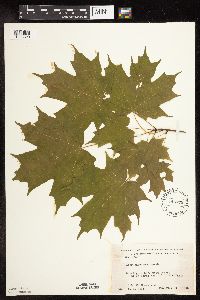 Acer saccharum var. saccharum Marshall 445776[1093890]Moore, John; Huff, N. 180171945-07-26 United States, Minnesota, Morrison, 13 mi. NW of Little Falls;;;;, 46.10932 -94.55374 |
MIN:Plants | 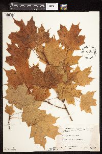 Acer saccharum var. saccharum Marshall 445789[1093916]Moore, John; Huff, N. 183361945-10-05 United States, Minnesota, Kanabec, Kanabec Co. Mora;;039N;24W;, 45.86068 -93.32753 |
MIN:Plants | 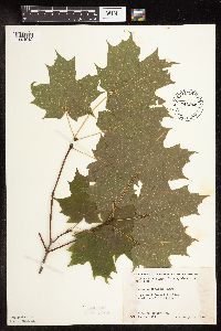 Acer saccharum var. saccharum Marshall 446243[1094012]Moore, John; Huff, N. 188921946-08-01 United States, Minnesota, Benton, Benton Co. 2 mi SW of Foley;;036N;29W;, 45.60368 -93.94558 |
MIN:Plants | 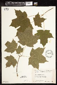 Acer saccharum var. saccharum Marshall 446255[1094005]Moore, John; Huff, N. 184751946-06-05 United States, Minnesota, Nicollet, 3 mi S of Klossner, Nicollet Co.;;110N;30W;, 44.32636 -94.4318 |
MIN:Plants | 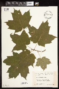 Acer saccharum var. saccharum Marshall 446399[1093948]Moore, John; Huff, N. 191571946-08-30 United States, Minnesota, Beltrami, 4 mi. NW of Ponemah;Red Lake Indian Reservation;;;, 48.06148 -94.97481 |
MIN:Plants | 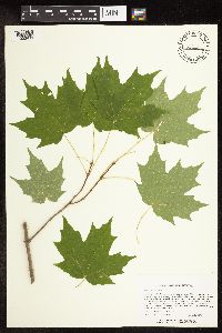 Acer saccharum var. saccharum Marshall 444632[1093899]Lee, Michael MDL15751996-09-18 United States, Minnesota, Todd, Oak Ridge Wildlife Management Area. Todd Co.; Oak Ridge Wildlife Management Area 3 miles southeastof Burtrum; on the east side of Stump Lake; T127N R32W SE1 Todd Co.; Oak Ridge Wildlife Management Area 3 miles southeastof Burtrum; on the east side of Stump Lake; T127N R32W SE1/4 NW1/4 Sec. 12. 127N 32W 12, 45.82427 -94.65419 |
MIN:Plants | 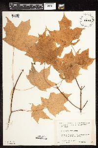 Acer saccharum var. saccharum Marshall 446501[1093998]Moore, John; Huff, N. 183621945-10-06 United States, Minnesota, Benton, Along St. Francis River 5 mi W of Oak Park, Benton Co.;;037N;28W;, 45.69185 -93.82275 |
Google Map
Google Maps is a web mapping service provided by Google that features a map that users can pan (by dragging the mouse) and zoom (by using the mouse wheel). Collection points are displayed as colored markers that when clicked on, displays the full information for that collection. When multiple species are queried (separated by semi-colons), different colored markers denote each individual species.